We didn’t have full Council meeting on this week, but instead dealt with a few things in an Afternoon Workshop format. We didn’t make any big decisions, but it is worth reporting out on what took place, as there were a few interesting topics discussed.
Stewardson Way Pedestrian/Bike Overpass
We received a presentation from the Ministry of Transportation on their plans to build a pedestrian overpass over Stewardson Way, as reported here. Several years back, the Ministry re-aligned the north entrance to the Queensborough Bridge to improve flow and once and for all solve traffic problems on 20th Street. At the time, this resulted in a shifting of the BC Parkway routing from the south side of Grimston Park to new pedestrian infrastructure at the bridgehead, the best part of the kilometer to the west. Seemingly ever since, people in the West End have wished for a return of the pedestrian connection at this location. The Ministry and TransLink are partnering to build it.
I raised a couple of concerns here, more in the category of things-we-need-to-do-now. The overpass will not actually connect to anything on the north side of the road. The all-but-abandoned section of the BC Parkway below Grimston Park merges into Mead Street, which dead-ends when it gets to 20th Street, and there is no other connection to any road or pathway in the West end, unless one wants to walk or ride their bike across a sloped grass field. So we need to figure out how to improve those connections. Also, there is still a user-friendliness “gap” on the Parkway down the hill on Stewardson between 5th Ave and 14th Street, like I talked about here. We will expect a report back from Staff on status of these gaps.
The bigger issue I have raised in the past about speeding on Stewardson and reclaiming the safety of our road space for active road users? Meh, no-one other than me seems interested in talking about that now. Goods Movement is still a bigger priority than livability of our neighbourhoods for pretty much everyone involved in transportation in BC. It is frustrating. But hey, free overpass.
Metro Vancouver Sewer Connection Project – Front St. between Columbia St. and Begbie St
Speaking of frustrating. We also received a presentation from Metro Vancouver engineering folks on a sewer line replacement project that is going to disrupt downtown traffic yet again, with a protracted closure of Front Street just west of Kelly O’Bryans. This is going to mean more truck traffic pushed to Royal Ave (the official alternate truck route), and more likely than not, a bunch of trucks illegally using Columbia, claiming no alternative.
The works are absolutely necessary to address sewer capacity needs for the entire northeast (Coquitlam, PoCo and Pt. Moody), and are the cost of living in a growing City with aging infrastructure. It sucks, but Metro is going to do its best to reduce the local impacts.
Queen’s Park Heritage Conservation Area Incentive Program: Economic Analysis Findings
As part of our ongoing implementation of the Queens Park Heritage Conservation Area, the City asked an external consultant to provide some economic analysis on some proposed incentive programs.
The City has already talked quite a bit about potential incentives to make the HCA more attractive, encourage conservation of heritage assets, and offset some actual or perceived costs related to the HCA. There has been quite a bit of stakeholder and public consultation around these incentives, but we also want better data about the actual financial value of different incentive programs. This report provided some of that background data, and creates some estimates of what, for example the value of allowing stratification of a laneway house or providing an extra 0.1FSR to a housing’s zoning entitlement may mean.
Because the value of any of these incentives is related to the assessed value of the land, there is also some analysis here of potential impacts on assessments that may result from different restrictions included in the HCA. If one thing is clear, it is that we simply cannot predict what those impacts will be in the medium timeframe, and it is too early to determine what the impacts on land values are in the short term.
There is, however, some interesting analysis of trends over the last few years in residential land values in Queens Park and comparison neighbourhoods in New West, which make for some interesting graphs: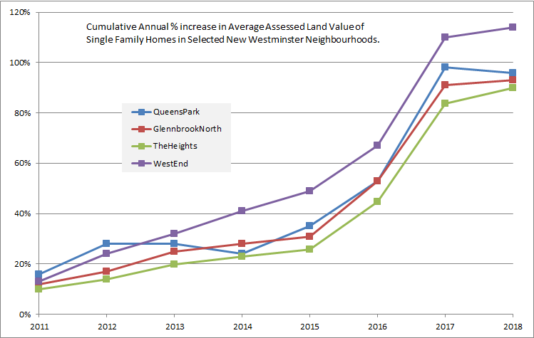
And they throw in some Vancouver neighbourhoods for comparison (probably because First Shaughnessy is the highest-profile Heritage Conservation Area in BC when it was introduced in 2015. Until Queens Park, of course)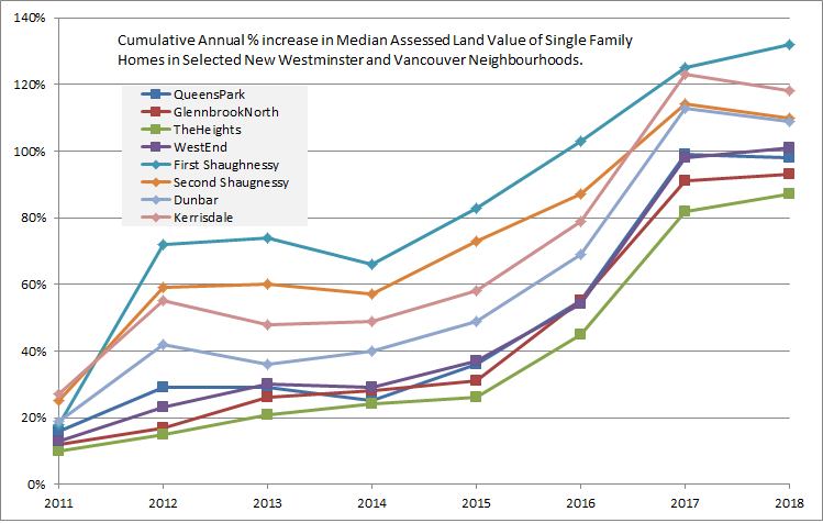
Request for Supplementary Information – 224 Sixth Avenue Heritage Revitalization Agreement (Statutory Right-of-Way for Potential Future Laneway)
This was a report we received for information, and it is a follow-up on questions raised by a resident last week as part of a Heritage Revitalization Agreement / Subdivision that will be going to Public Hearing on April 30.
Among the many long-term planning policies the City has is the principle that all residential properties should be serviced by a lane. This is because lanes make it easier to provide utility services, improve the streetscape, reduce the need for front driveways that impact traffic and the pedestrian realm in neighbourhoods, etc. Clearly, not all houses have lanes now, and there is no active program to build more lanes, but as a planning principle, the City want to move towards securing land for lane rights-of-way as development happens.
This property in Queens Park is one where there is no lane, and where the front of the house faces a collector road where we would prefer to not have driveways in the long term. As the City wants a Statutory Right of Way for a laneway here, the request for a Subdivision is the optimum time for the City to secure that SRW. Who knows, in a hundred years, we my put a lane there, but in the meantime, we have the SRW. One less thing to worry about for a future Council and future neighbourhood plans.