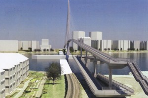
Amongst the great legendary structures of New Westminster, none has seen as much rumour and speculation as the mythical Bridge to Queensborough.
Not the Queensborough Bridge, but the allegedly announced, apparently planned for, and suspiciously funded but not-quite-yet-built fixed pedestrian crossing from the Quayside boardwalk to the east tip of Lulu Island, where the burgeoning neighbourhood of Port Royal is remaking the shape of Queensborough.
The reality of the bridge is that it is, indeed, “planned”. There is even a bit of money set aside for it. Any time I raise the issue with anyone at the City they assure me it will definitively be built. It is next on the list for DAC projects, done by 2016. Or 2017. Or 2019.
Now, for most people, a fixed piece of transportation infrastructure between the Quay an Queensborough seems like a great idea- who could be against it? It is like being against the Quayside Boardwalk, or the Central Valley Greenway, or the Seawall. The only people seemingly against it are those few familiar names who are against everything the City does. In a curious game of whack-a-mole problem-finding, they raised various complaints: it was too costly; it was an eyesore; it would destroy the “Submarine Park”.
These complaints were based on an early, and very preliminary, engineering assessment done on potential crossing options. This original plan was what you get when you give engineering consultants as free reign to build a bridge: it is big, expensive, and does the trick. A good starting point, but hardly the best of all possible solutions.
The reason we are even entertaining this idea to build a pedestrian bridge to Queensborough is due to DAC funding. The bridge is one of several identified projects that rose out of a slick deal cut between the City and the Provincial Government related to the old Riverboat Casino (which morphed onto the Starlight Casino). The background is complicated, but when the Province wanted to change the funding model for Casinos, New Westminster asked to be compensated for loss of potential income, and the Province agreed, but the money had to be earmarked for specific projects (could not be put into things like general revenue, or operating a ferry service, or paving Daniel Fontaine’s back alley). Amongst the earmarked projects were the newly-completed Queensborough Community Centre upgrades, other park amenities in Queensborough, and the Anvil Centre. Long version short, the City has a small pile of money from the Province they need to spend on building a pedestrian link to Queensborough.
This led to the 2009 report which provided early design ideas (including the drawing above), and led to a significant amount of whinging from the Quayside residents (although there is a general ambivalence about the project displayed in the Quayside Community Board minutes from 2009 when the project was announced).
That is not to say the original bridge plan was not without problems. The projected cost was much greater than the DAC funding available. A fixed crossing would need to be 22m above the water (~20m above the landings) due to requirements for maintaining a navigable channel for river traffic, which would potentially make for ungainly ramps of something like 400m length to accommodate pedestrians, wheelchairs, bikes, etc. Apparently, the Railway was not so chuffed about the idea of the City driving piles to support a 20-m-high bridge next to their 100-year-old pilings. The original landing spot for those ramps was where the current “Expo Submarine” park is located. Finally, the eyesore issue that if the City built the cheapest bridge possible, it was going to be ugly, and if they went for the grander vision, it might not be a vision shared by everyone (grandeur-wise, and cost-wise).
There were some creative alternatives floated. A ferry service, or a gondola. Maybe I will cover those in a future post, but extremely short version: show me the business case.
So it was exciting a couple of weeks ago when the City announced a new set of plans developed in partnership with the owners of the railway bridge: Southern Railway. The big difference this time around is the low elevation of the bridge, which makes life much easier to pedestrians and cyclists, but means the bridge must swing or draw to allow marine traffic to pass. A City Councillor I was chatting with last week even suggested it could be built to accommodate an ambulance for emergency use.
