Signs of Protest

I was driving along Highway 3 this past weekend, along one of my favourite roads. I have driven and cycled this road more than a hundred of times in my life, the 600km from my first Home to my adopted Home. It seems I know every curve, every hill, every summit (can name them off the top of my head, and picture each clearly: Allison, Sunday, Richter, Anarchist, Phoenix, Paulson), every place where the Police hand out tickets.

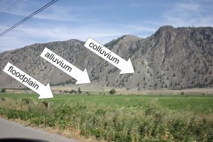
One of the spectacular stretches for a geologist is west of Richter Pass, as you drop into the wide, flat Similkameen Valley, bounded by the vertical wall of the Catherdal Range of the Okanagan Mountains. The valley floor has a classic underfit meandering river flanked by the shallow drapes of alluvial fans leading up to much steeper scree slopes of colluvium. Traditional ranching and hay fields on the slopes are increasingly being turned over to viniculture, while the orchards of Keremeos continue to pound out unreasonably good cherries, apples, and stone fruit.

Aside from the human uses, these grasslands represent a rare ecosystem in British Columbia: A sagebrush desert. With rapid development up the mountains in the adjacent Okanagan Valley, these ecosystems are under a lot of pressure. To call it a desert makes it sound, well, deserted, but this area has the highest concentration of threatened or endangered species of any similar-sized region in Canada; at least 23 different listed species, from Pacific rattlesnakes to Flammulated owls, and one-third of the red-listed species in the Province. Protection is spotty, development is encroaching, and the ecosystem is threatened.

With this in mind, the (Liberal) Federal Government signed a memorandum of understanding with the (Liberal) Provincial Government in 2003, to do the appropriate feasibility studies towards developing a National Park or National Reserve Lands (the first in the Okanagan). The MOU includes the statement:

“On February 11, 2003, the Government of British Columbia announced in its Speech from the Throne its interest in exploring the potential for establishing a new National Park Reserve in the Okanagan area, and its “Heartlands Economic Strategy” by which economic development plans will open up new opportunities for tourism, resort development and recreation, among other things, in the Province of British Columbia”
Sounds good; a Park plan which will balance out economic growth in an area of intense tourist interest and very unique geography and ecology (currently unprotected by any National Parks), to provide recreation opportunities while limiting impacts. In a region full of seasonal hotels, campsites, fruit stands, and tourists, who could possibly oppose?

People who like to shoot things and burn hydrocarbons for entertainment. That’s who.

A local “No National Park” movement began, led by a small but determined group of hunters and ATV enthusiasts out of Oliver, BC, who were offended that their chosen recreation activities may be even slightly encroached upon in the name of protecting ecological lands or endangered species.

Long story short, after 9 years of consultation, the Province caved. With her characteristic ability to solve problems, bring people together, and provide leadership you can believe in, our Premier was unable to voice support for a Park that had broad local and First Nations support, with backing from a broad range of people and groups across the country. Apparently recreational lead-shooters and gasoline-burners have a lot of voice in one of the last remaining BCLiberal strongholds in the Province. The Federal Conservative Government, citing a lack of interest on the part of the BC Liberals announced this spring that they would no longer explore the Park. Even while they announce a big park up North that will apparently feature spectacular mining expanses.

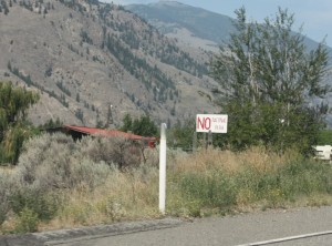
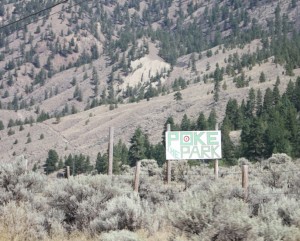
The fight may be over (or not…), but the signs are still up all through the Similkameen Valley. To me, this entire story has been about a 9-year sign war played out across the Cawston countryside. That small, organized group did a good job plastering Highway 3 with red-on-white signs, stating “No National Park”, confusing the hell out of thousands of RVs from Alberta and Germans in rental cars every year. Really, it does not present the most inviting message to passing drivers: “Wer ist gegen einen Nationalpark?!?”

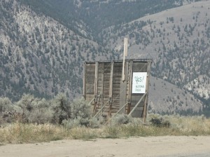
It has only been the last year or so that a counter-protest sign campaign has started, using much more positive, if derivative, imagery:

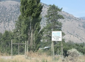
And even some more creative approaches:

And now, with the entire thing in limbo, maybe the time was right for the ultimate modern slacktivist movement:

Now there is a protest I can believe in.

?

Where I been

I’ve got excuses.

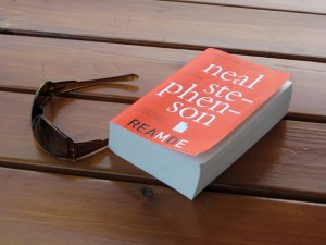
I haven’t written much in the last two weeks, but I have been on vacation, pulling Scotch Broom, digging a km of Mountain Bike trail, sawing down trees without a chainsaw, drinking beer to stave off the heat, and, most time-eating of all, I picked up the latest Neal Stephenson novel, REAMDE.

This was an impulse purchase the way off to vacation, but I knew what I was getting into. I still remember where I was (on a school bus in the Nevada Desert) the first time I read chapter 1 of Snow Crash and met The Deliverator.  I love the stuff Stephenson writes, and I had held off until the new one came out in Paperback, partly to reduce the size of the damn thing to less than a curling rock, and partly because I don’t have time for fiction right now.

Alas, it is pretty engrossing. It reads like an action movie (much like his break-out novel Snow Crash), and large swathsof it take part in my old neighbourhood – the Kootenays. So far, it is less intellectually satisfying than some of his other books. I think this is because it is Stephenson’s first book where he has fetishizes guns. Much like he fetishized nanotechnology in Diamond Age or Science-as-Religion in Anathem, this is a book not about guns, but where guns are the locus of most plot advancement from the opening scene of a family reunion shoot-off. And unlike other topics he has fetishized in the past (radical environmentalism in Zodiac, code-making and code-breaking in Cryptonomicon), I am just not all that interested in guns as a topic.

Still, the guy can write some compelling characters and his level of detail makes me want to have a copy of Google Earth open while I read, just so I can scan the streets he is describing in Xiamen, China or Georgetown, Washington. (he also has an early humourous tip-of-the-hat to the legend that the original idea for Google Earth itself was cribbed from his novel Snow Crash)

I’m only 700 pages in, so bug off, I’m reading. Its Summertime.

Starting 2012 Off-line

As has become custom, I have been using the year-end holiday season to recharge my batteries, chill out, relax, etc. This means a lot of reading, a lot of new learning, and very little writing. Along with the increasingly-frustrating ravings of Dr. Moore, I have been reading Master Transportation Plans, found a couple of interesting new on-line sources of better science around environmental issues, and have even been reading a bit of fiction: a rare luxury for me. So I have not been writing much.

However, once again, the News Leader asked me to contribute to the year-ending Looking Back / Looking Forward feature, on the topic of local environmental issues. I can’t help but feel 2011 was a good year locally for the environment, just as giant steps backwards were taken nationally and internationally. 

I’m not one prone to New Years Resolutions – my life is full enough of half-realized aspirations – but I do have some plans for 2012. Obviously, the Master Transportation Plan and Pattullo Bridge public consultations will be meaningful and interesting. There are a couple of big captial projects at the Royal City Curling Club that have been on the back burner too long, and I will relish being the “Past President” of the NWEP, seeing what exciting new directions the group takes under the refreshed Board and crazy-smart and outspoken new President. I also need to take a little more analytical approach to my gardening, the shotgun approach is getting frustrating. Oh, and finish the basement renos, and ride my bike more, and replace the back fence, and spend more time on Saturna, and stop using the car to commute so often, and get a day of curling practice in every week to work on my draw weight,  and… what was I saying about half-realized aspirations?

Hare Krishmas!

There will be a serious reduction in blogging for the next week or two. It’s the holidays, days are short, and you really should be talking to your family, friends, and neighbors, not checking on on a grumpy blogger. I should be talking to mine, instead of being a grumpy blogger.
If you really can’t get enough of reading my diatribes, be sure to check out the Year End edition of the News Leader, where I will be answering a few questions about the year in review and the year to come, along with some other New West rabble. 
In the mean time, I will be reading transportation plans, checking out my copy of Dr. Patrick Moore’s Ph.D. thesis, sipping scotch, and generally enjoying life. 
And, early in the New Year, I will resume starting sentences – or whole paragraphs – with conjunctions, and will pull out a whole new quiver of prepositions to end sentences with. 
Oh, and I think I am going to finally change the name of this Blog – the  “Green” thing is so 2010. 
Finally, can I show off my present?
Happy 2012 everyone.

Place holder post while I get some things done

It seems I am slacking on the posting, so we’ll do a quick catch-up.

I am actually trying to put a post out regularly at my other Blog, seeing as how we had a short but reportable vacation the weekend before last, and it was travel blogging that got me into this entire blog thing in the first place.

The big news around these bits is, of course, the Election. On the 19th, I hung out at City Hall with the 10th to the Fraser brain trust, and it was fun to watch the results come in while a couple fo them tweeted, and we all shared general hilarity at the absurdity of our own presumed predictive skills (although the room was remarkably bereft of beer). When the advance poll came in, only 1,400 or so votes, and the Mayor had a lead of 66% to James Crosty’s 29%, I did a bit of mental math and said: “It’s over”. I’ve taken just enough statistics to be dangerous, and recognized that, assuming there wasn’t something wildly skewing the data, a 30-point lead from 10% of the votes is statistically significant. Even the early results from Council were pretty close to the end result. It was only the School board numbers that shifted towards the end, with Mortensen and Goring trading spaces “on the bubble” for most of the night.

Overall, I am satisfied with the results. I am happy Mayor Wright will get one more term, and hope he will bow out gracefully and pass the torch in three years. I am ecstatic that Jonathan Cote and Jaimie McEvoy got so many votes, and have solidified themselves as the real leaders of this Council Chamber. Of the “Old Guard”: Betty, Lorrie and Bill are all hard workers with their hearts in the right place, even if I disagree with where their heads are sometimes! I think Chuck will add some vigor to the board, will always be good for a quote, and will be able to develop the City’s relationships with senior governments (especially after the upcoming Provincial election).

On the School Board, I am equally happy to have two new and very bright lights (Dave and Jonina) leading the polls. After having a few conversations with her, I am sure Mary Ann Mortensen will more than make up for the sparks created by Lori Watt; they may not be sharing the same space on the political spectrum, but they seem to share similar approaches to a political discussion.

So enough with the politics, back to the peaceful and orderly operation of the City. Master Transportation Plan anyone?

Oh, and back to the subject of beer at City Council meetings. Let me solemnly declare I am for it. A keg in the lobby, sell $4 drafts, much better than watching on TV at home. That is the kind of revenue-generating activity I can get behind.

Old Glory

Last weekend, my Mom had one of those birthdays ending in “0”, bringing the Johnstone Clan together in the Kootenays to do the presents, cake and singing thing that is obligatory for such events.

Born in Castlegar, I don’t get back there very often; home is very much New Westminster now. Any idea I used to entertain of moving back to the Koots is usually pushed aside pretty quickly by thinking about everything I would need to give up: my City Girl wife (whom I am still rather fond of), my job (that I also quite like), my funky little house (that I can almost afford), my curling team (who are just good enough), riding a bike in the winter (without snow tires), and this great New West community into which I have somehow become immersed.

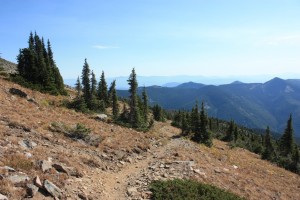
That said, I think the hike up the Plewman trail to Old Glory Mountain is my favourite place on earth.

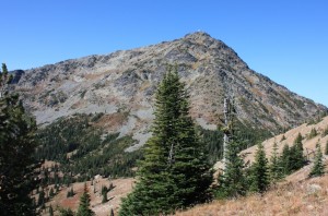
Old Glory is a 7,800-foot peak in the Rossland Range, part of the Monashee Mountains in the West Kootenay. It is the highest peak in the range, but not as tall as the highest peaks in the Valhalla Range, which is clearly visible from the top. What makes Old Glory so great is it’s 3,400-foot prominence, the fact most of that prominence is above the tree line, making for spectacular sights much of the way up, and the accessibility of the peak by a relatively easy 2-hour hike.

The first time I went up Old Glory, Mt. St Helens was erupting, so it was probably summer 1980. I remember this distinctly, as I thought every cloud passing over head was ash from St. Helens, and when I found out the rocks that make up Old Glory were “volcanic”, I turned that into pre-teen angst that it would erupt when we were there. Of course, Old Glory is made up of Jurassic volcanic rock that erupted in an oceanic island arc something like 180million years ago, long before this part of the world had accreted to the North American continent. So eruption risk was pretty low.
Last time I was up there was a year ago at the Seven Summits Poker Ride. That day it was windy enough at the summit on a cloudy day that hoar frost was forming. I had to provide proof to the Seven Summit organizers that I had made it to the top of Old Glory with my bike in order to get a “Bonus Card” in the Poker run competition, so here is the i-Pod video I used for proof (also providing proof I am not Stephen Speilberg… or even Kevin Smith).

It was damn cold up there for Labour Day, but at least we didn’t get snowed out like the previous year.

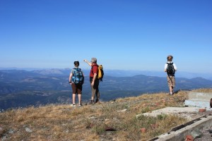
This trip, I walked up Old Glory with my brother and two of my nephews, both a couple of years older than I was the first time I climbed this hill, and they soldiered up there like solders (totally resigned to their fate and no doubt cursing the names of their commanders for leading them into certain death and discomfort), and this time the sky was blue and the view was spectacular.

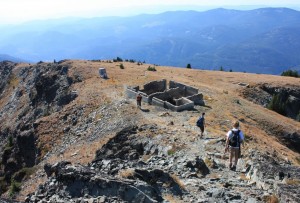
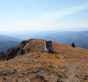
One of the great features of Old Glory is the mini-ghost town on top. This was once the location of Canada’s highest elevation weather station, and a forestry fire protection lookout. The lookout shack is still there, kept up as a hiker’s shelter, but all that remains of the homestead is foundations and scrap metal.

And a very windy outhouse.

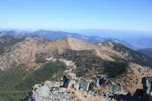
But for me, the best thing is the view from the top: the rolling hills of the Rossland Range, all just touching the tree line, with the Valhalla and higher Monashee ranges in the distance, landmarks all around that I can just barely recognize from my growing up climbing mountains, skiing, and riding bikes. This landscape is my favourite place in the world.

Probably made more so by the fact I only get to go out there once in a while to visit. And that’s OK.

Grand Canyon Part 2: The Kaibab Limestone

The top of the Grand Canyon, and much of the rubbly plain surrounding it, are made up of rocks of the Kaibab Formation. The Kaibab is a limestone unit, somewhere around 270 million years old, which puts it in the middle of the Permian Period of the Paleozoic Era.

The world was a different place in the Permian. This is a time before there were birds or mammals, even the dinosaurs had yet to develop. The dominant land animals were synapsids, which look rather like modern lizards but were more mammal-like than reptilian (with differentiated teeth and quite possibly fur). They were almost completely wiped out in the Great Permian Extinction (lucky for you they weren’t, as one of your ancestors was a Permian synapsid).

There were no flowering plants in the Permian, but cycads, ginkgoes, and ferns were common. In the sea, 300 million years of Trilobite domination was about to come to an end, and echinoderms and mollusks were rising, especially a new-fangled cephalopod mollusk, the Ammonite, which was starting it’s impressive 200 million-year reign as king of the Sea.

The Permian was also the last time that all major continental land masses were collected together through Plate Tectonics into one “supercontinent”- Pangaea, leading to bad T-shirt ideas ever since (people calling for Pangaea’s reunion rarely consider that the supercontinents correlate very well with massive declines in biodiversity, but I digress). In the part of Pangaea that is now northern Arizona, there was a shallow sea facing to the west, with the shoreline shifting around somewhat, as they are apt to do on million-year time spans, which brings us to the limestone.

Limestone is generally deposited in shallow ocean water as a result of biological precipitation of carbon dioxide and calcium out of the water column – which is a fancy way of saying: it is all shells. Not just shells of bivalves like clams and oysters, but structural parts of corals, echinoderms, sponges, and perhaps most importantly, microscopic plankton. As this pile of dead and discarded shell material is compressed, heated and dewatered, it cements together into a very hard rock: limestone. Well, it is actually kind of soft by rock standards, and it is easily dissolved (on a geologic timescale) when exposed to meteoric water. However, it often forms large, homogeneous blocks that can be very resistant to erosion in arid place, like the Colorado Plateau into which the Grand Canyon has incised.

In places west of the Grand Canyon, younger rocks are piled on top of the Kaibab, but around the canyon, these younger rocks have been eroded away at some point in between the 270 Million years since it’s deposition in the shallow ocean and it’s current exposure more than two Kilometres above sea level.

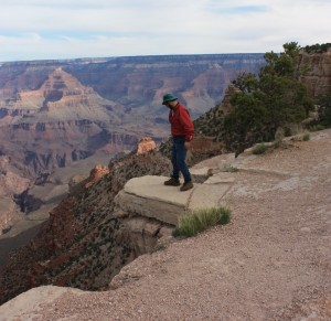
Did I mention my fear of respect for heights?

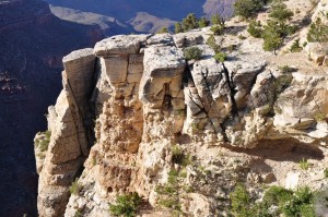
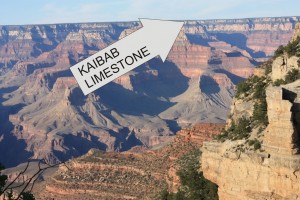
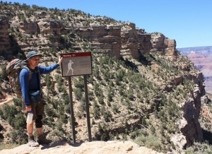
The Kaibab is hard enough to form vertical walls at the Canyon rim, some more than 300 feet high. It is also distinctly grey in colour, making a visible band around the canyon rim, and is easy to differentiate from the reddish sandstones and shales below. The underlying Toroweap formation is not as resistant, and forms rubbly slopes below the Kaibab cliffs.

Kaibab – you can recognize it from 10 miles away.

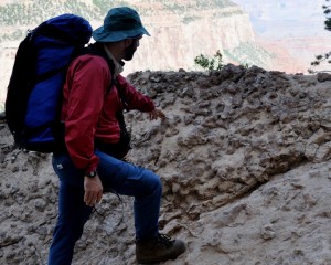
Close up, the Kaibab is grey in colour, and is variously massive (showing little internal structure) or mottled with chert nodules and fossils. It is also variously mixed with relatively thin shale or sandstones beds, just enough to give a sense of bedding.

This poor, suffering bastard could use a bed. Fortunately, there is
beautifully expressed bedding in the Kaibab Limestone outcrops behind him!
Chert nodules weathering out of Kaibab limestone. Note pointing doofus for scale.

“Chert” is a micro-crystalline form of quartz (more or less pure silica) that is much harder and less soluble than the limestone so it really stands out from the limestone surface. These nodules formed in the limestone when it was buried and hot groundwater with silica dissolved in it percolated through the limestone depositing crystals. These look like fossils, and indeed some of them do form around incongruities in the limestone caused by fossil structures, or in tunnels bored through the sediments on the ocean floor by various animals who might be grazing through the sediment looking for food (like worms do in soil) or making tunnels or tubes to live in (like some types of shrimp or clams might do). These are “trace fossils”, and I will go on at length about them in later posts.

I like trace fossils.

East Point Geology

As I have noted before, in one of the earlier lives I was a geologist. Like most people who are once geologists, I am always thinking like a geologist, in that I can never walk by a rock without looking sideways at it, and making up stories in my head as to its origin.
A summer long weekend on the Gulf Islands (the Canada Day Lamb Roast on Saturna Island is a family tradition, going on long enough now that I have an assigned volunteer role) gets me looking at rocks again, and rocks I know well and love.
I actually did my Master’s Thesis looking at rocks of the Nanaimo Group on the Gulf Islands, so I have a particular affinity to Upper Cretaceous sedimentary rocks, and always see the sandstones, conglomerates and mudstones of the Gulf Islands as “my rocks”.
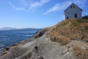
On Saturna, I spend most of my time out on East Point, where the exposures of the Geoffrey Formation are dominant. This is a very late Cretaceous set of rocks, probably 75 million years old. For context, 75 Million years ago there were dinosaurs walking about, all the mammals in the world were shrew-sized or smaller, and the dominant form of sea life was various hard-shelled cephalopods we call ammonites. The Coast mountains were actively building up, as were the Rockies, and the coast was much more like the west coast of Chile is now, with the mountains the size and scale of the Andes, and a deep subduction trench off the coast. Vancouver Island was, for all intents and purposes, not there.

There is some debate about where these Nanaimo Group rocks were, geography-wise, when they were deposited. There is no doubt they were deposited into an ocean, facing west, near a coast open enough that they were subjected to large hurricane-force storms on a regular basis. Most of the geology and the palaeontology suggest they formed in the temperate Proto-Pacific (just a little south of where they are now), but there is a pretty interesting body of geophysical data suggesting they were much further south in the tropics, around present-day Baja Mexico, when they were formed. The “Baja-BC Hypothesis”. I for one side with the geologists over the geophysicists, purely on a weight-of-evidence argument, but that is neither here nor there.

The Geoffrey Formation rocks of Saturna were deposited as part of a submarine fan complex. They were deposited in the ocean, deep enough that surface waves, even during the biggest storms, did not effect the sediments on the ocean floor. They were influenced, however, by large submarine “turbidity flows”, or large landslide-like events that occur occasionally in the ocean. Walking along the shores of Saturna, the evidence of these events is written large on the rocks.
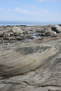
In the ocean, sediments are deposited fairly slowly. As the currents away from the shore are pretty gentle, it is only fine materials like silt and clay that get out there to be deposited. The sand and coarser material is washed around on the beaches and near the shore, and is constantly re-worked by wind and wave and bugs in the soils, but there just isn’t enough wave energy to move them our very far out into the ocean. The exceptions are big storms, which can ramp up enough of the wave energy to move much of the sand and gravel built up on the beaches further out to sea, or big flood events along deltas, when there is a big migration of river sand out to the delta front. For the most part, however, the coarser sediments get to the shore (or just offshore) and basically stay there, building up over time into big, unstable, shelves of loose material.

To quote Thom Yorke: gravity always wins. When these shelves build up large enough, they eventually begin to fail along submarine canyons. When large amounts of water-saturated sand and silt, with a little gravel mixed in, begin to move under water and flow down these submarine canyons, they do so in the form of “turbidity currents”. These high-speed flows of are a lot like the “mudslide” that just buried Highway 1, but because they are underwater and are water-saturated, they behave very differently. The turbidity of their flow keeps them suspended on a laminar base, and they can therefore move very far along a shallow slope with little energy loss. Most remarkable is what happens when friction rises to a critical point and overwhelms the forces keeping the flow moving: the sediments almost instantly “freeze” in place. This makes them very distinctive from river sands or beach sands or even dunes in a desert, where the constant working by currents result in complex structures like cross beds and dunes and ripples.

Fancy as this may sound, I’m not making this shit up. We know these things happen because we can go to places like the modern Indus Fan or even the Mendocino Trench and see these things operating today. Geology is great that way: uniformitarianism rules all.

Even more fun with the submarine fans is that the material they transport can include the fine gravel or coarse sand moved out to the shelf by floods or storms, along with the layers of fine mud deposited in the calm deep ocean, and fossils from boththe shallow water and from the deep water, and even pieces of terrestrial plants like logs and leaves, flushed into the shallow ocean, all mixed together in a chaotic matrix. At East Point on Saturna Island, we can see the deposits of all this.
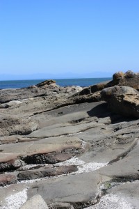
Mostly, the Geoffrey Formation sandstones at East Point are thick and massive, with only minor interbeds of pebble to cobble conglomerate, and only widely dispersed silty mudstone layers. The sandstone represents the bulk of the material stored along the shoreline (not too dissimilar to the sand built up off the coast of Vancouver Island now, to hundreds of metres of depth), and the bulk of the material that filled those submarine channels when there were turbidity flows, and they are the material that sometimes “froze in place”. These massive sandstone beds (“massive” in geology does not mean it is really big, it means that the entire bed is homogenous, without cross beds or ripple marks or bedding planes) are the beds that tend to erode in a pattern known as “taphoni” or honeycomb weathering, one of the most distinctive features of the sandstone of the Gulf Islands.
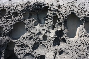
“taphony” weathering

There are also a few conglomerate beds mixed in with these sandstones, where material from closer to shore was swept out though one of these long canyons. This material is more dense than sandstone, so it concentrates along the bottom of the flow, where it erodes into the underlying sand material and creates a sharp contact on the bottom of the bed. Sometimes other material is mixed in with the gravel, especially shell material, now fossilized.
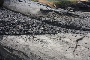
Gravel bed, note “sharp” contact at bottom where gravel eroded into soft sand, and more gradual shift to sand on top.
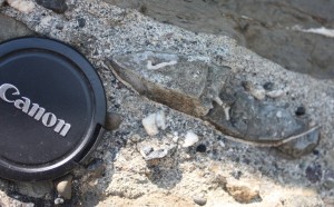
That big oval to the right of the lens cap is actually a section through a bivalve shell, which got broken up as it moved along with the graveland sand, but preserved finer mud material from where it was living within it’s hollow. I’m not a paleontologist, but that there is a ~70 Million year old clam of some sort.

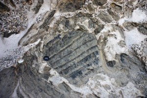
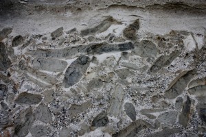
But on the south edge of East point, down by the water is a really special bed. Collected along the bottom of a bed are polygonal hunks of mudstone. These chunks often have bedding structures within them, showing the mud was laid down gently over time, with only the faintest traces of currents in thin silty interbeds. Often, there are trace fossils, showing that some type or animal eked out some meagre existence within those mud beds.
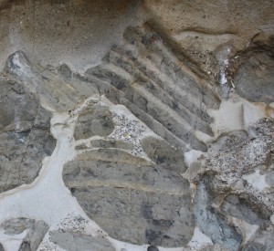
Note the bedding is only within the chunk of mud, which is oriented chaotically compared to the sandstone beds, and compared to the bedding in other chunks of mud. Also, the edges of the mud chunk are broken up, or even bent. These big mud balls are colloquially called “rip-up clasts”. They are literally hunks of soft sediment deposited on calm water then ripped up by the turbidity current and swept along in the flow. We know they were pretty firm and compacted, because they didn’t completely break up in the flow but remained cohesive and moved along like a wet pile of cardboard. We know they were soft sediment and not “rock” because they were easily folded, bent and had their edges eroded by the flow. They are mud, so they are denser than the saturated sand, and collect towards the bottom of the flows, and are mixed in with gravels and fossil fragments. When the flow stopped, they were “frozen in place”, without the ability to fall into a layers. The result is some pretty amazing patterns:
So there I was, on a Gulf Island long weekend, looking at a rock sideways and making up stories of their origin. Drives the iCandy crazy.
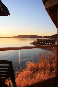
Ubiquitous Gulf-Island-sunset-from-the-pub shot.

I’m a Eco Geek

At work, I’m an environmental coordinator; as a volunteer, I help run a grassroots environmental non-profit. On vacation: I tour recycling plants in far-off locales.

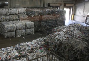
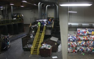
OK, it might have been a one-off. An old friend I was visiting in Illinois happened to be teaching and Environmental Science course, and invited me to tag along on a field trip she had organized for her class. The destination was the Scott Area Recycling Centre and associated Electronic Demanufacturing Facility:

Scott County and the City of Davenport, Iowa, are trying to reduce the amount of waste going to landfill (for all the environmental and economic reasons one would expect), and their curbside blue box materials come here. In Davenport, they do “commingled” recycling, and this facility is where the waste is separated and compressed for shipping to whoever will buy the recycled materials. They receive mixed paper, newsprint, plastics #1 and #2, and metal and glass containers. There are a series of magnets, air-blown density sorters and other equipment, but the majority of the actual sort is done by hand.

The facility runs as a non-profit, but is reliant on near-by markets for the recycled materials. In this case, that means at least three solid markets within a 300-mile radius, or the economics just don’t work out. They closely track the commodity value of their incoming products, just to break even. $150/ton for aluminium cans, $75/ton for first-use plastic #1, $12/ton for mixed paper. Since there is no break-even market nearby for plastics other than the first two, they are not accepted. Glass is a real money loser at $2/ton, but they receive it for two reasons: it is heavy, and therefore boosts diversion numbers, and as a marketing tool for recycling, it would be silly to not collect the one material (beer and other bottles) that people associate most with recycling. Perception matters with Community Based Social Marketing.

The results? A County-wide diversion rate approaching 25%. This is good compared to no diversion at all, and adds to the lifespan of the local landfill, but pales in comparison to areas with aggressive diversion targets, such as Metro Vancouver (Currently 55%, aiming for 70%). Scott County is not aiming for a specific number when it comes to diversion, only “continuous improvement”. Still, for semi-rural Iowa, any diversion is a success.

One interesting difference between here and there is tipping fees, what garbage collecting companies or municipalities pay to dump materials at the recycling yard and the landfill. At the Scott County landfill, mixed household waste is $24/Tonne. At the recycling centre, it is $23/Tonne. I’m sure the small difference is significant to large-scale waste collectors, but compare the numbers in MetroVancouver : $82/Tonne for mixed garbage, $59/Tonne for “Green Waste” that can be made into compost. Before you think this is another example of the Government Screwing you becasue you are Canadian, the tipping fee does not reflect the $130/Tonne it costs to manage Vancouver’s waste. The fact our recycling programs generate a modest profit creates the incentive that has led to our >50% diversion rate. and the reason we are aiming to improve it:

Which leads me to a conversation I had last month with one of our esteemed members of Council. During a discussion on waste diversion goals and incentives, I suggested that the cost differential between landfill and recycling (resulting in part from our choice to export our garbage more than 300 kilometres), is the main reasons we have achieved such remarkable diversion rates. He called me “cynical”.

I don’t think that suggesting regional governments make decisions based on economics, and the sound fiscal management of the Taxpayer’s assets is “cynical”. I would think it is “responsible”. We don’t divert because it is the right thing to do, we do it because we simply cannot afford not to.

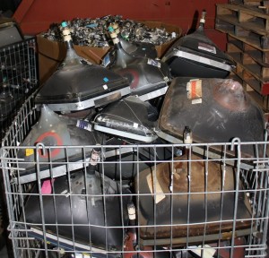
More later on how Scott County manages e-waste, and the death of the CRT display.

A day in the life of plastic bags.

I guess if you are in an airport, mother nature got screwed anyway, but everything about the airport experience tells me to never fly again.

You can’t put so much more than a car key in your carry-on, for fear you will use it to commandeer an aircraft (let us not mention the axe in the cockpit), so we are forced to check baggage or just buy all new stuff at your destination. All US carriers now charge an extra $25 pre bag for luggage when flying in from Canada. Apparently Air Canada does as well. No warning ahead of time, only when the electronic kiosk that replaced a person in the airport asks for your credit card. Of course, at that point, what can you do, complain?

Then there is the theatre of airport security. Every three steps someone checks your boarding pass, you must fill out this form here, carry it through three checkpoints, picking up another form there, remove your shoes, belts, dignity or anything else with mass, drop off the first form, give your life history and vacation plan, drop another form there. Does anyone actually think there rituals make us safer?

Figuring it would be nice to bring some BC produce to our hosts in Illinois, we decided to pick up a couple of bottles of BC wine at the Duty Free. The middle aged lady at the Duty Free shop proceeded to pull out two separate plastic bags and put a bottle in each. We asked for only one bag. She paused, processed, and then grabbed a third plastic bag, wrapped a bottle in it, stuffed it into one bag then stuffed it all into the second bag with the other bottle. Was she trying to spite us? Was this some sort of reaction to our provocation?

No, it was a misunderstanding. We had to explain to her the idea was that we only wanted one bag, you know, the environment and all… completely baffled her. It was like we were asking her to do vector calculus. She froze. Confused. Needed a reboot. No-one in 40 years of work or personal life had ever introduced to her the idea that one may want to reduce the amount of free plastic they get. Zero Waste has a long way to go.

The only saving grace of airports is they have airport bars. This one was out of beer.

Vacation on.