Price Talk

I was fortunate to be able to attend the taping of a Price Talks podcast. It was a real transportation policy geek fest (and, alas, a real sausage fest). Jarrett Walker is a transit planning consultant, an author, and an academic with an incredibly cosmopolitan view of urban transportation systems. He has worked on 4 continents, and can see the universal truths expressed in the great variety of built forms in cities around the world. The conversation was wide reaching, from Coriolanus to Elon Musk, from the inescapable geometric truths of urban transportation to aesthetic as a guiding principle in urban planning. There were dozens of quotable nuggets in the talk, some I will be chewing on for a long time as I think about how to apply them to my neighbourhood and community

My favourite nugget, however, was the 4-minute summary of ride hailing and its impact on communities. You can skip to 1:09 to hear this as part of the Q&A at the end of the evening, but to fully appreciate his answer, you need to hear his earlier discourses on the phenomenon of Elite Projection, and how it is the scourge of most North American transit planning.

Walker is much more profound on this topic than I can ever be, but the short definition of Elite Projection is the tendency for the most wealthiest and most influential minority in a population to think what is good or attractive to them is best for everyone. It exists throughout hierarchical decision-making, and once you open your eyes to it, it is everywhere. In urban transportation, it is manifest in Musk’s The Boring Company and in “cute streetcar stuck in traffic” approaches to urban transit world-wide. There may be a few local examples: here, here, or even here.

The heart of his argument about ride hailing is best summed up in this quote (based on his observed experience in American cities where it has rolled out):

…it has been a great way to draw out the worst aspects of elite projection, because people who can afford it have become addicted to it, [and] expect as a matter of course that it will be available… [but] like anything to do with cars, it only works as long as not many people use it.

Part of the problem is that providing mass transportation in an urban area is not a profitable business. It never has been, and never will be. Uber and Lyft are losing billions of dollars a year, their underpants-gnome business plans being propped up by venture capital silliness, while they can’t even pay living wages or provide basic workplace protections to the people doing the labour (we aren’t allowed to call them “employees”). At the same time, they cut into public transit revenues while increasing traffic congestion making those transit systems less reliable, pushing customers over to the ride-hailing industry, exacerbating the impacts. He doesn’t even touch on how ride hailing demonstrably correlates with less safe roads for people in cars, pedestrians and cyclists, but he doesn’t need to.

The warning for Vancouver is that the introduction of ride hailing could be “really terrible” for our traffic systems and our livability, for obvious reasons. The promise of ride hailing is that it reduces parking demand by increasing traffic congestion – this is not conjecture, but the demonstrated experience around North America. That is no win at all.

For you Uber fans out there, Walker does provide a clear policy recommendation about how we can make ride hailing work in our jurisdiction without externalizing these real impacts, but I guarantee Francesco Aquilini and Andrew Wilkinson ain’t going to like it…

Give it a listen, it is a great conversation:

A Night with Jarrett Walker: Building Human Transit with Shakespeare, String & Elephants in Wine Glasses

Miner improvements?

I went on a bit of a rant last week in Council on pedestrian crossings, and it is worth following up a bit here to expand sometimes on the things I rant about. In this case the subject was something we can all agree on – making pedestrian spaces safer in the City – but the details of the discussion outline how difficult it can sometimes be, even when everyone is on the same page. The hill on Richmond Street provides a great case in point about how we want to do things differently, but are stuck with a bad legacy to clean up. And that costs.

The Fraserview neighbourhood is somewhat unique in New Westminster. Most of our community is based on a well established and dense street grid that reflects how humans move around their communities – a layout that is “human scaled”. The Fraserview neighbourhood was developed out of the abandoned BC Pen site in the 1980s, which was the Canadian peak of auto-oriented suburb design. This is not the fault of the council or staff of the time, or of the people who live there now, but a result of where we were and how we valued space as a society in the 1980s.

The buildings on this map are coloured by the decade they were built. See Sapperton and Queens Park with a blend of ages and traditional dense street grids, Fraser View with 1980s houses (red) and 1990s condos (blue) with the suburban road scheme so sexy at the time.

At the time, New Westminster built this strange little auto-oriented suburb in the gap between two dense urban community centres. Since the primary built form was “house with a garage facing the street and a private yard in the back” (note this is a generally unusual built form in New West!), the streets were designed with the same exact mindset – they will be used to move cars between garages, and not much else.

This resulted in some road design ideas that were the opposite of current thinking. Instead of straight lines and a dense grid to connect pedestrians, we build a meandering “arterial” road connecting capillaries of culs-de-sac. Of course these are ostensibly “family neighbourhoods”, so we kept the speed down to 50km/h by putting up a sign, and left plenty of road space for road-side parking and car passage. The curvy hill part of Richmond has wide 20m right-of-way between property lines, but the road profile part (travel lanes and sidewalk) are a pretty typical 14.5m. This feels wider partly because the sidewalks are less than the 1.8-2m wide we would shoot for in 2019, there is no buffer space between the sidewalk and the road, and the parking spots along the road are unmarked and not very heavily used. Add this up, and you have no visual “friction” giving drivers cues to slow down. Wide roads tell people to drive fast, it is human nature.

This is how the road was built in the late 1980s:

I like to think if we were building the road today, it would more like this:

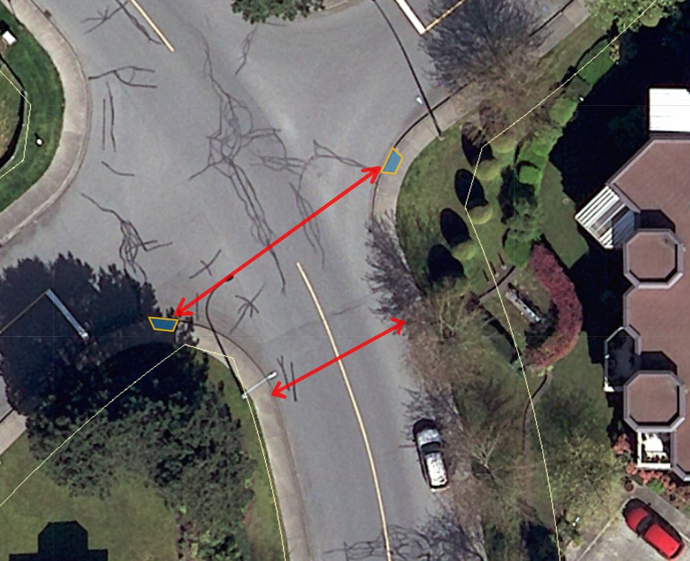
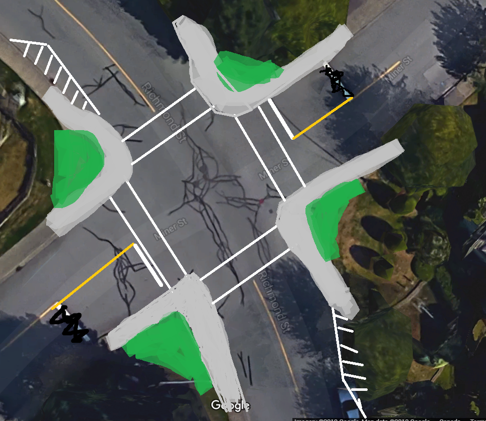
But that is just a representative cross section. There is another issue that makes the pedestrian experience even more uncomfortable. If you look at the intersection of Richmond and Miner, where staff were asked to evaluate placing a crosswalk, you see the corners are rounded off to facilitate higher turning speeds:

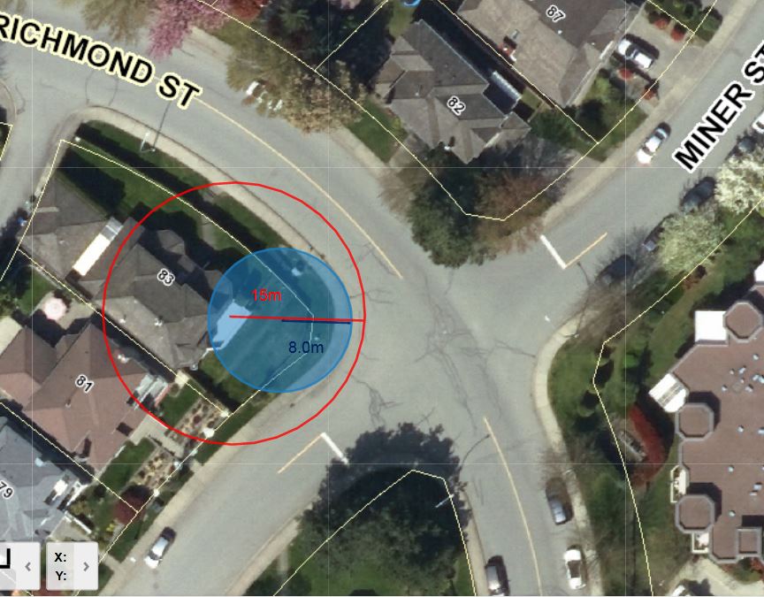
The technical term for this shape is “Corner Radius”. In this diagram you can see the curb follows a curve with a radius (blue) of about 8m, and the effective turning radius (tracing the track a vehicle would actually use for a right turn) is closer to 15m. By modern standards, this is a crazy wide corner, more suited for a race track than an urban area. Reading up on modern urban streets standards, curb radii smaller than 1m are not uncommon, and radii bigger than 5m (15 feet) fall under the category of “should be avoided”.

The impact of such a wide radius is bigger than just facilitating faster turns, it also creates a variety of sightline problems. See how far back the stop line is on this corner? How far around the corner can a driver practically see? This results in the confusing stop, creep forward, peek, make aggressive move intersection action that opens up opportunity for driver error. This is made worse when there is no clear demarcation of where the parking zone ends near the intersection. Our Street and Parking Bylaw says you can’t park within 6m of the nearest edge of an intersecting sidewalk or crosswalk, but it is less clear where that 6m buffer is when the sidewalk geometry is like this. moving the stop line further forward creates a conflict with pedestrians trying to cross the street at a rational place – where the curbs are closer.

For pedestrians, these big radius corners increase the crossing distances, expanding the time that someone (especially a young child or senior citizen, who travel slower) is exposed to traffic. Crossing Richmond Street at this intersection, the distance between curb cuts is almost 20m, where the sidewalks are only 11m apart a few meters outside of the intersection:

So what do we do? There are lots of useful guides like these great NATCO manuals that show how an intersection like this can be made safer for pedestrians. We can narrow the road at the intersection, paint new crosswalks, and reduce the turning radius through curb bulges:

But my bad painting skills here represent couple of hundred thousand dollars in concrete, road paint, asphalt, curbs, soil, planting and storm drain realignment (never mind a complete re-design of Richmond Street to pull it into the 2000s as I showed in the cross sections above; that would cost millions). And this is one intersection in a City with more than 1,000 intersections, some better designed than others, some more used than others, some with worse safety records than others. I want to change this specific intersection tomorrow, but who is going to come to Council and ask us to raise property taxes by 0.3% to do it? And why do it here and not at the intersection that bugs you in front of your house?

All this to say that some changes are going to be made to Richmond to improve pedestrian safety, and three other intersections (8th Street at 3rd Avenue, 12th Street at Queens, 6th Avenue at 11th Street) that have been prioritized for this year’s Pedestrian Crossing Improvement program, totaling about $200,000 in work. The work is, necessarily, incremental, and because of that it is never enough, and never fast enough.

Be safe out there folks.

Active Transportation

I know I haven’t blogged about this week’s Council meeting yet, I haven’t had time to edit and get the post up. It’s coming, I swear. In the meantime, I want to get this out, because it has been in my outbox for a little while and it has suddenly become time sensitive.

The Provincial Government is asking the public about active transportation. I have been known to criticize the Ministry of Transportation in the past about their approach to “cycling infrastructure”, but I am going to hope that this is the start of a new approach. You have until Monday to answer their questions!

If you are too busy to write your own thing, you can go to HUB and fill in their form letter, but as an elected person, I like to receive input that brings something new – a 1000-person petition is not as powerful as 100 personal letters that each bring different nuance. So I encourage you to take a few minutes and fill in the answers yourself. If you want some inspiration, here are my answers I will submit this weekend:

Question 1: What does active transportation mean to you and how does it fit into your life?
Active transportation means healthier, safer, happier communities where youth are safe to ride a bike to school and the elderly are comfortable walking to the grocery store. It is about replacing fossil fuel dependence with transportation independence. When we build the infrastructure to support active transportation, we give more people the freedom of choice in how they move around their community, reduce their reliance on volatile international oil markets, keep more of their money in the local economy, build resiliency in our communities and connections between neighbors.

Question 2: What are some of the challenges in your every day life that prevent you from moving towards using active transportation modes? What are some of your concerns about active transportation?
As an active transportation user, and a local government decision maker, the biggest challenge I face is addressing the “gaps” in our systems that make active transportation less safe and less comfortable. I am lucky to live in a compact, dense community where most services are a short walk or bike ride away, but so many of my neighbours still feel it is unsafe to make the journey unless surrounded by two tonnes of steel, which in turn reduces the perceived safety for other community members.

Too much of our active transportation infrastructure is developed as baubles attached to the side of new automobile infrastructure. Sidewalks, crosswalks, overpasses, cycling lanes, and transit supports are evaluated in how they support or hinder adequate “Levels of Service” for automobiles, while the high LOS goals (fast, uninterrupted vehicle travel) acts to make active transportation space less safe and less comfortable. An overpass over a busy road is seen as a pedestrian amenity, when it actually serves to provide more space for automobiles to have unrestricted travel. The trade-off is usually a longer more difficult journey for a pedestrian and introduction of a new barrier for people with mobility challenges. We need to see active transportation alternatives as a solution to community livability, not as a hindrance to the flow of traffic.

Even the language of “transportation” vs. “active transportation” reinforces the idea that using your feet and your own body to move around is somehow lesser than – a secondary consideration to – using an automobile. I have to explain to people that I use transit to get to work, I use a bike to run errands, I walk to City Hall, like that is some sort of radical action instead of a rational and normal way for a person to live in on a modern urban city. Let’s switch that default, for the good of our communities, the good of our budgets, and the good of our planet.

Question 3: What is the most important action that government could take to promote active transportation? What is unique in your community or region that needs to be considered?
Of course, funding. Local governments are straining to provide services as our infrastructure ages. We receive 8% of the tax revenue in Canada, yet own more than 50% of the infrastructure. This inequity is sharpest when it comes to transportation infrastructure. Billions flow for highways and bridges that direct automobiles into our communities (with, admittedly, the requisite active transportation baubles attached), but the local improvements to help us move around within our communities are tied to expectations about “Level of Service” for those automobiles. The cycle is vicious.

My community has one of the highest active transportation mode shares in the province. New Westminster is a transit city, it is an easy city to walk in and the revolution in electric assist bicycles means that residents no longer need to be athletes to manage our hills. We have some of the lowest car ownership rates in Canada. This is not an accident, the City has a dense urban fabric that puts most services near where people live, we are concentrating our growth around these transit hubs and working to make our pedestrian spaces safer and fully accessible. Yet we are choked by through-traffic that makes all of our active transportation spaces less safe and comfortable. This load means we need to spend millions of dollars every year in maintaining our asphalt to provide the level of service through-traffic expects, while struggling to find the thousands of dollars to build better cycling, pedestrian, and transit-supporting infrastructure.

We need help making our transportation system work better for our community, but as long as that transportation funding is tied to our ability to get cars moving, to provide high automobile “levels of service”, we are putting out fires with gasoline.

Bullies

I’m on vacation, I’ll be back next week. However, this letter to the editor of the Burnaby Now entered my social media feed, and much to MsNWimby’s lament, I had to take a few minutes to pen a retort. I thought of sending it to the Burnaby Now, but I thought it would look weird for a New West City Councillor to get something like this published in a Burnaby newspaper, so instead I’ll just post it here.

Letter: Why can’t bullied kids just get with the program?

Editor: Last weeks’s Burnaby NOW had a letter from Diane Gillis raising important questions about why pedestrians don’t work harder to protect themselves from getting hit by cars. I think it provides a great platform to offer similar safety tips for youth suffering from another well-identified danger in today’s society: schoolyard bullying.

It does not matter who is right and who is wrong in schoolyard bullying – it is the bullied child who is at greatest risk of injury or psychological trauma.

Sadly, there are too many children who do not understand or know of what they can do to avoid bullying. I chair the communications subcommittee of my local Concerned Parents of Athletic and Cool Children chapter, and we coordinate anti-bullying messaging for our children, and those who do not qualify. At the November CPACC meeting, we discussed ways to reduce bullying.

All children should consider these anti-bullying safety tips.

  • Wear more attractive / fashionable clothing so the cool kids will not notice your lack of flair. If wearing professional-sports-team-branded clothing, be especially aware of the sports franchises preferred by the local cool kids.
  • Don’t go to places where bullies hang out, like malls, schools, or outside.
    If you have to go to those places, look out for bullies.
  • If you see a bully, run away really fast.
  • Don’t make eye contact with bullies.
  • Don’t use your phone and/or headphones, or carry anything of value while walking where bullies might spot you.
  • If a bully approaches you, hand them your lunch money and beg for mercy.
  • Wear a helmet.

Something I think is telling. Yesterday afternoon at about 3:30 p.m. – just after school gets out and when most kids were playing sports or hitting the Mall – as I was driving past a schoolyard in Burnaby, I saw a skinny, nerdy kid getting taunted by a group of pretty cool-looking kids.

When I saw his Minnesota Wild t-shirt, his last-year’s Walmart Nikes, wire-rim glasses and his clarinet case, it was all I could do to stop from yelling “Hey Nerd!” and slapping the little loser myself.

There is a lot more to the concerns of many of us regarding keeping all kids safe from bullying. And as long as we can continue to blame the victim, none of us will ever have to recognize our own personal responsibility to keep our community safe for all, or even acknowledge what the real dangers are.

ASK PAT: Small trees and Beg Buttons

neil21 asks—

Howdy. Two questions having just moved here from Vancouver’s West End.

1. Why are the street trees so short? Is it just time (but I thought this city was older) or the species? The streets are really hot without that shade.

2. At 6th and Carnarvon, pedestrians don’t get to cross without pressing the button. Even if pedestrians are crossing the same way on the other side.
2b. Also why aren’t your beg buttons those buttonless ones like you have for the bikes? Those are better.
2c. Also why does 6th and C have beg buttons at all? Just let peds cross with green cars always.

Welcome to New West. I would love to hear more about your decision to move here from our western suburb, and your experiences since making the shift. The theme of my answers to the above will be “A City is always a work in progress”. We are now headed the right direction, but have more work to do.

1: (caveat: I’m not an arbourist, but I have a couple of suppositions) First, the trees may be younger than you are used to. The City of New Westminster, with the exception of Queens Park (the neighbourhood) and a few parts of Glenbrooke North and Sapperton, really lost the plot on street trees a few decades ago. It may have been the fashion of the time, the cost of development, a mandate by the electrical utility, or just short-term thinking, but our urban forest was cut back in a devastating way. Our canopy cover City-wide is less than 18%, which is similar to Vancouver, but low compared to much of North America. It was only a few years ago when New Westminster introduced a new Urban Forest Management Strategy, and started to a) proactively protect the trees we have; and b) ramp up plans to plant trees and bring back more canopy cover. Unfortunately, the ultimate results of this will not be seen for another decade or two. That said, although the best time to plant a tree is 20 years ago, the second best time is today, and we are getting on it.

That said, it is also possible that trees are smaller above ground because they are smaller underground. Trees need healthy root systems to prosper, and our 150-year-old streets and sidewalks and utility corridors mean that the area of healthy nutrient-rich and porous soil around many of our newer trees is limited. This may mean staff decided to plant diminutive tree species to respect the available growing area, or it may be that the lack of soil is keeping the tree from meeting its ultimate size. There is a bunch of new engineering practice around creating “soil cells” as part of new street tree installations, but see last paragraph about 20 years.

2: (Mostly) because the City is old, doesn’t have endless money, and until recently, it wasn’t a priority.

Beg Buttons (the pejorative name given by pedestrian advocates to buttons that must be pushed by pedestrians in order for the red hand to become the white man at light-controlled intersections when the cars get a green light) were all the rage at one time, because everybody important drove, and pedestrians were just another thing that needed to be managed within car spaces to get traffic moving.

Our new Master Transportation Plan, however, prioritizes pedestrians for the first time, so we are working on changing these things. That said, Beg Buttons can still serve a purpose for system-wide traffic management in more pedestrian-oriented urban areas. They can assure that crossing times for wider roads are adequate for slower pedestrians when they are present, and not too long when they are not. They also make the audible crossing signal for the hearing impaired work better. As always, the devil is in the details.

In some places, we still have older Beg Buttons (even old-style small-button ones in place of the larger panel-type ones) in places where more modern treatments would be appropriate. These are being replaced as budgets allow on a priority basis. Every year, Transportation staff do a review of all  identified crossing improvement needs, place some draft priorities on them based on safety, potential to dovetail with bigger projects or adjacent development, and other factors. They pass that priority list through the Advisory Committee for Transit, Bicycles and Pedestrians, the Access Ability Advisory Committee, and the Neighbourhood Transportation Advisory Committee, then spend their budget making the changes. Sometimes that means curb bulges, marked cross walks, lighting changes or updating the signal operations. All of these things are ridiculously expensive, hence the need to set priorities.

In some places, the Beg Buttons will remain (although I hope we will eventually migrate all to the more accessible panel-type ones) because they are a useful tool. If well applied, they make crossing safer for pedestrians, especially in lower-pedestrian-traffic areas. However, when they are not well applied (as you point out a 6th and Carnarvon, and I can point out a few more in the City), they create an impression to pedestrians that are not a priority in our public spaces, and sometimes go so far as to create inconvenient barriers to pedestrians. Perhaps a good example is all of the crossings along Columbia Street in Downtown, where there is an almost constant east-west flow of pedestrians, and pedestrians should see the white walking guy every time cars get a green light.

Trucks in the City

Douglas College has been running an interesting talk series this year under the banner of “Urban Challenges Forum”. The final episode of this semester occurred on Wednesday night, and deserved a better turnout than it received, considering the amount of social media bits and watercooler shatter we have in New Westminster around the topic: the livability impacts of truck routes and goods movement in our community.

Fortunately, they recorded video of the event, and will (hopefully?) be posting it on line. It is worth the time to see how the four panelists speak about trucks from different viewpoints: an urban systems geographer, a representative of the trucking industry, a representative of the Port Authority, and the CAO of New Westminster, a City that is (arguably) impacted most by the negative externalities of “goods movement” in the region.

I want to give a quick summary of my take-away points before raising the question I never got to raise at the event, partly because of the time constraints, partly because no-on needs to hear from a Politician when actual thinking people are speaking, and partially because I wasn’t sure how to phrase my question in the form of a question*.

Peter Hall (the geographer) reminded us that transportation, by its very nature, makes us selfish, and makes us act in shamefully selfish ways (speeding, tailgating, yelling at others). This is at least partly because it isn’t an ends, but a means, and its hassles are preventing us from meeting these ends. Add to this our general ignorance about freight, and we get a selfish ignorance about goods movement – we all want the benefits, none of us understand why we need to tolerate the costs. Trucking also has many benefits and externalities, and they are not evenly distributed. Altogether, this makes it a vicious political problem, not made easier by jurisdictional overlap.

Matthew May from BST Transport and Peter Xotta from the Port of Vancouver gave similar messages about their respective industries: they need to keep the goods moving in the National Interest. You ask for tomatoes in the store, you need to deal with trucks. You want a vibrant economy, you need trucks and ports. You live in a Gateway, and we will accommodate your community as best we can (even want to make you happy!), but the mandate is to drive the economy.

Lisa Spitale gave a concise summary of some of the interface issues New Westminster has dealt with over the last few decades. With rail and roads encircling the community and a Regional Growth Strategy mandate to be a dense Urban Centre supported by (and supporting) transit, we are a hot spot for the externalities of goods movement, by rail and truck.

If I had a point to make at this event (again, I could not put this in the form of a question), it is that we have *chosen* to accept the level of negative externalities that come with a large number of diesel trucks in our neighbourhoods.

To frame this point, we need to put aside the local-goods-delivery for a moment and talk about the larger getting-stuff-from-Port-to-hinterland-through-logistics-hubs part of this equation. This is what separates us as a “Gateway” city from most other regions, and is the foundation of both the Port’s arguments on this issue and the emphasis of the Gateway Council model that has commonly dominated our regional transportation conversation. But what kind of Gateway have we built?

Here in New Westminster, we host one end of a 114-year-old single-track swing bridge that is the only rail link crossing the Fraser River west of Mission. The City of New Westminster has something like 14km of river shoreline under Port of Vancouver jurisdiction, with about a third of that backed by industrial land, much of it under the Port’s direct control. Much of this land is used for logistics, cross-shipping, container storage, and other aspects of that all-important gateway-to-the-hinterland business. Yet over all of that space there are (2) conveyors moving aggregates and chips on/off barges, and one (1) pier occasionally used to move breakbulk lumber. These are the only location in New Westminster’s extensive port lands where anything is taken on or off of a boat.

The only contribution our Port lands make to the Gateway is providing space to move and store trucks, and facilitate the movement of goods in and out of trucks. Unfortunately, New Westminster is not alone in this.

How we move goods through the region is a choice we make, not a foregone conclusion. For these hinterland goods in containers, we have chosen to use trucks to move a large portion of them intra-regionally. A cynic would suggest that is because building waterfront infrastructure to make better use of short sea shipping and barges is expensive. Upgrading rail infrastructure so a single swing bridge isn’t the only vital link across a river that has seen 30 lanes of highway built across since that single track was installed, is expensive. Relying on roads and bridges is comparatively cheap from the view of the person who has to pay for the initial capital, because taxpayers will often pony up for “congestion reduction” investment, and the other costs (noise, pollution, public safety) are completely externalized, at least partially in the form of decreased livability of our communities.

I’ve made this rant before.

Since 1808 when Simon Fraser first tasted salt in the Sto:lo, there have been strains resulting from the needs of the Gateway to the Hinterland and the needs of the people living on the river’s shores. We can, however, find a better balance between these forces. It must include acknowledging that externalized costs of fueling the Gateway need to be accounted. Trucks are part of a functioning modern society, but their true role cannot be understood as long as we subsidize them over other options.

*I was once at a forum-type event where the request for “question from the floor” was prefaced by this proviso: Your first sentence must be in the form of a question; there should not be a second sentence. I thought that was brilliant.

ASK PAT: Road Closures.

JF asked—

Pat, what are the City of New Westminster’s policies regarding road closures that impact cycling routes? Is there a requirement for the company requesting the road closure to identify and provision safe detours for people walking and bicycling through construction zones.

This past fall and winter has seen a large number of road closures in the Sapperton area for combined sewer separation and RCH related projects, and another sewer separation project on 7th Avenue near Moody Park. The Crosstown Greenway passes through both of these areas.

Many, many times over the past few months I have encountered road closures on the Crosstown greenway or connecting streets that I utilize. Most of these closures have little in the way of advanced warning and any detours in place don’t have cycling or walking in mind – ie being detoured down an alley onto Braid Street – FUN!

I’m a daily bicycle commuter passing through New West to/from my place of work in Burnaby and easily fall into the capable/confident category of rider. I don’t have any problem being detoured onto Braid or 8th Avenue and cycling alongside traffic moving at 50+km/h, but for a new or less confident rider I could easily picture them saying “forget it. I’m taking the car.” Not exactly the goal for any Active Transportation minded community.

To answer your first question, the City’s policy is that road closures caused by road/utility works are required to be well signed, and that safe alternate routes for all users including cyclists and pedestrians are to be maintained at all times. What you have discovered is that the policy sometimes fall short in practice. This is something I have spent much time ranting about in the past. It is a perennial problem, one that is (hopefully) getting better, but is (admittedly) a work in progress.

There is a *lot* of roadwork going on right now in New West. As you surmised, much of it is related to a sewer separation program accelerated somewhat by winning a federal grant to help pay for some of it. The situation in lower Sapperton has been especially intrusive, as that is where the sewer separation work is most intense along with utility works related to the expansion of the Hospital.

Almost all of this work is done by contractors (a city the size of New West doesn’t really have staff to do works at this scale anymore), and requirements to maintain rights of way and accommodate all types of road users are written right into the tender documents. They hire road flagging crews, do traffic plans, our engineers sign off on those plans, and our engineers sometimes drop by the site to see how things are going. However, these jobs are complicated and worksites are dynamic, so maintaining 100% access is difficult, and traffic plans necessarily shift as the project requires. This is often when the best laid plans get set aside for a bit, and people are inconvenienced. Sometimes, of course, they simply don’t care. Either way, the City needs to be let know.

Often, it results in a call to the Engineering Department or a SeeClickFix entry, an e-mail to a Councillor, or my better half bending my ear over dinner (if it impacted her riding route to work, like it did on 13th Ave last month). This usually means one of our engineering staff goes out there, sees what the situation is, and the contractor (if they haven’t already) are told to make it right.

This is, unfortunately, the reality of this type of work. I simply don’t know how to make it better.

I say that as someone who rides bikes around this city all the time, but I also say it as someone who at one point in his life got paid to stand with a hardhat next to an excavator or drill rig with flagging crews protecting me from traffic and vice versa. Any time you are interacting with heavy equipment, public streets and underground utilities, there are unpredictable conditions you encounter, and you need to make adjustments to plans on the fly, and the impact on traffic is but one (important) aspect of your contingency plans.

I was actually compelled early in the year to drop by the upper Sapperton project when I received two separate compliments from cyclists I know about how well the flagging personnel managed two different conflict situations with a bike route. This seriously never happens – I never get people pointing out when something goes good – so I had to check it out and let the Director of Engineering know. That said, I have also gone through lower Sapperton in the last couple of weeks, and have found through-signage lacking at times.

This is all to say I think we are doing better that we used to on this, as we have updated our policies. Our Engineering Department requires that cycling access or alternate routes must be part of the traffic plan, and that safe pedestrian access routes must be considered prior to starting work. At the same time, it still happens that I run into road works with no warning, and little indication of how I am supposed to route around them.

My best advice, when this happens, is to contact our engineering operations desk (604-526-4691  or engops@newwestcity.ca) and tell them about your experiences. We don’t have engineers on site every moment of the project, and if they don’t know there is a problem, they cannot address it. You can contact me as well, but I’m just going to contact Engineering Operations anyway, so you can cut out the middle man.

If you are into filling out web forms (you got here, didn’t you?) you can also use the SeeClickFix App to report these issues, with the bonus of being able to track how staff respond to them.

Making a complaint to Engineering may help in the short term, but it also helps longer-term. There are a limited number of contractors who do this type of work in the region, and a contractor that receives complaints about their inability to manage our traffic and access requirements is one we are less likely to hire for future contracts. Their ability to address traffic access is part of the quality assessment staff need to do at the end of every contract. That is, ultimately, the only way we will get better compliance.

I just want to say one more thing. This situation is frustrating at the time, but please try to be kind to the persons holding the Stop/Slow paddles at the worksite. Their job is surprisingly difficult and stressful. They often work in terrible conditions (noise, dust, weather, silly hours), and have to deal with irate drivers, angry neighbours and demanding construction managers, while carrying the responsibility of keeping the public and the workers on the site safe – often by putting themselves in dangerous situations. They know you are frustrated, they have little control over the hazards they are protecting you from, they honestly want to get you on your way as quickly and safely as they can.

Innovation! Transportation!

Next week is Innovation Week in New West. It actually starts with an Opening Reception at City Hall this Friday night which should be off-the-hook (with free music and video presentations and a special Steel & Oak release!) If you are in the #NewWest #Twitterati, you probably know this already, but some of you may wonder: “What is Innovation Week? And what can it do for Me?”

Let. Me. Tell. You.

As part of New West’s Intelligent City initiatives, Innovation week is a showcase of how technology, innovation, and sharing information can make our City work better, can make us a stronger community, can make businesses more prosperous and residents happier. It is about strategically leveraging innovative ideas like the City’s award-winning Open Data portal with hardware like the BridgeNet fibre network to build a better and more equitable future.

Now I read that last paragraph, and it is all true, but it doesn’t really tell you what Innovation Week is, does it? Let me try again.

Innovation Week is a series of panel discussions, hands-on workshops, networking sessions, tours and activities all open to the public, and inclusive of all ages, experiences, and interests. There will be classes to teach kids about coding, a Hack-a-Thon for teams of coders to develop new tech, forum discussions about new ideas, chances for Tech start-ups and businesses of all sizes to connect with Private and Public funding sources to bring ideas to reality. All wrapped up in fun enough with arts and music to keep your mind fresh. Through the week, you will be given reasons to dream, and information and resources to make that dream work.

I will probably write again about more events (if I get time, or else I will live tweet from there!), but I want to call attention to two events in particular, as they are interesting (I think) to the entire region:

Metro Conversations is a talk series I have been helping to organize with council colleagues from other municipalities. Out Fifth Conversation will be on Tuesday the 27th in the evening on the topic of The Promise of Innovations in Transportation. But instead of just dreaming of autonomous vehicles and hyperloops and Tunnels, we are going to ask whether the technological promises addresses what we actually want from our Cities – safe streets, livable neighbourhoods, sustainable communities, social connections and equity. This will be a fast-paced hour-long conversation, free to attend, but you might want to register as we don’t have the biggest room.

As a bit of a primer: watch this video form 1958, and ask yourself, is this the community we want? And how does this differ from Elon Musk’s vision of tunnels and hyperloops “connecting” our community.

The second event I with broad regional appeal for people like me who care about Sustainable Transportation and how it interacts with City Planning will be the Transportation Forums on March 1st. I’d suggest you book the time off work and enjoy the entire day, but you really don’t want to miss the evening event, as Mobility Pricing is sure to be the hottest political topic in the Lower Mainland through the fall elections and into 2019.

The evening forum will feature the Chair of the Mobility Pricing Independent Commission, one of the most respected and outspoken Urban Planners in Canada, and an Economist who can unpack the idea of what “fairness” is when it comes to paying for our regional transportation infrastructure. The Mayor of New Westminster will moderate the discussion, and it is free to attend.

If you are like me, you may be interested but apprehensive about Mobility Pricing. I have engaged in TransLink’s “Its Time” consultations, and understand how Mobility Pricing works in Singpore and London and Helsinki, but am cognizant of the challenge we have in Vancouver setting up a system that fits our region, and can be politically supported by the broad interests of the region. I’m hoping this forum will answer some of the questions I have, and allow me to better engage with the proponents and critics of road pricing.

There is a tonne of other great stuff happening between February 23 and March 3. Please come out and support these events, and thanks the many sponsors who help lead these conversations in New West. That link again.

Ask Pat: Stormont redux?

CH of Burnaby asks—

Have you changed your views on the Stormont Connector now that there is an opportunity to revamp the access to the new Pattullo Bridge? You were against the connector a few years ago. Do you still want all that traffic meandering through your residential areas? 

To your first question: No. And your second question sets up a false premise.

The Stormont Connector is a really expensive solution to a poorly defined problem, as I wrote about at length six (!) years ago. Nothing has substantially changed since I wrote that, except that the plans for Pattullo replacement have shifted from a 6-lane bridge to a 4-lane bridge, and the Port Mann now provides 10 toll-free lanes shifting even more regional traffic to that bridge. If anything, we have less reason to spend billions of dollars building a freeway through the middle of our city, and asking Burnaby to do the same.

Do I want rush hour traffic meandering through New West neighbourhoods? Not really, but I also don’t want a freeway running through the centre of the City, and there is no reason to believe that adding the latter will take away the former.  It simply doesn’t work like that.

So TransLink and the Ministry of Transportation are going to replace the Pattullo with a similar-capacity bridge, and there will be some minor increases in vehicle through-put, mostly related to better designed intersections at each end of the bridge. I think the opportunities New West has through this process are to improve the east-west connections through our City. We can make it safer and easier for Victoria Hill residents to walk and cycle to Downtown or to QayQayt. We can safely connect the Central Valley Greenway across McBride (finally) with enhanced connections to the proposed Agnes Street Greenway. We can vastly improve the public realm around Albert Crescent Park. There are many potential wins here for the City of New West, I just don’t see how a Stormont connector is one of them.

This topic also gives me a chance to give props to North Vancouver MLA Bowinn Ma, whom I was able to chat with at the Pattullo press event on Friday, and who continues to impress with her straightforward smarts and ability to engage on technical topics. It is refreshing to have an MLA speak so clearly and knowledgeably about urban transportation issues as Ma did on twitter last night:

Yep, She gets it.

Whither a plan?

It appears the Mayor’s Council are once again on the hot seat.

For the best part of a decade, the Council has demonstrated apparent amity, likely due to recognition that they were going to need to work together to get a disinterested Provincial Government to support any kind of transit funding stability as the region’s growth exploded. Alas, they recently seem ready to take a step back into parochial foot-shooting. With a federal government hot to spend money on urban infrastructure renewal and low-carbon transportation and a provincial government equally willing to prioritize sustainable transportation investments, the 10 year plan developed by a consensus of Mayors is suddenly being questioned by the very Mayors that put the plan together.

The first shot in this apparent internal battle was the vote to make Mayor Corrigan of Burnaby (the one Mayor who questioned the 10-year vision all along, leading random bloggers to suggest he was “transit regressive”) the new Chair of the Mayors Council, giving him more power to set the agenda and negotiate with the province over the terms of transit investment. He did this (presumably, because the voting was secret ballot), only through a one-mayor one-vote system that provides the Mayors of Anmore and Lions Bay equal voices to those of Vancouver and Surrey. However, most votes at the Mayor’s Council have a weighted vote system in an effort to closer approximate the population differences across the region and the relative sources of the budgets that TransLink spends.

The Agenda for Thursday’s Mayors Council meeting is out, and it suggests this tenuous situation will be tested right away. The only substantive agenda item is a motion put forward by Mayor Greg Moore of Port Coquitlam:

…that the Mayors Council supports the implementation of the Phase Two Plan in early-2018 as planned, including construction of the Surrey-Newton-Guildford LRT, Millennium Line Broadway Extension, the SkyTrain Upgrade Strategy and the replacement of the Pattullo Bridge, along with increases to bus and HandyDART service and funding for walking, cycling and Major Road Network infrastructure across the region;

There is more there (you can read the Agenda and resolution, with all its whereases and nuanced language, here), but the message is clear. At least one member of the Mayors Council (the one who happens to be the Chair of Metro Vancouver) wants the plan forward to be made clear to Translink planning staff, the Provincial and Federal Governments, and to all of the regional partners involved in planning our transportation system. It is clear that at least some of the mayors on the Council still believe in the vision, see its urgency, and are willing to speak up to the pall of suspicion that has resulted from Mayor Corrigan’s election (not the least by semi-informed bloggers, like me)

This is the vote to watch to see who is on-side with well-developed and integrated sustainable transportation investments, and who is willing to delay solutions to our regional transportation challenges for yet another decade.