BTWW 2019

My ride to work for Bike To Work Week yesterday was pretty typical. Nice weather for a 20km ride, and 4 people attempted to murder me.

One was a person in an SUV blowing through a stop sign into my path on a residential Vancouver street, which was easy to forgive because she gave me that ubiquitous “oops” wave. One person pulled a bone-headed u-turn right in front of me as I am going down a hill on another designated bike route in Vancouver, causing me to lock up both wheels on slick streets. No “oops” wave this time, but he did give me a dismissive spin of his tires as he shot away from the scene, which I guess is acknowledgement. One was an attempted dooring on a traffic-calmed bike route, followed a few hundred metres later by a guy in a CLK brush-passing me at 50km/h when I try to stay out of the door zone on another traffic calmed bike route. I foiled them all.

There were also two places where City works crews (one in Burnaby, one in Vancouver) chose to completely close off a relatively safe bike route with no warning and no indications of alternative routes in order to do horticulture work, which is kinda a nice nod to Bike to Work Week.

There were also three places where I was forced to make sketchy moves on the bike because of horrid cycling infrastructure failures. One infrastructure failure in Burnaby is a long-standing grievance at Royal Oak station that will get someone killed eventually. Another is the relatively new one in Burnaby I have already lamented, that the City of Burnaby has now made even worse with the addition of a pedestrian fence. The third one is related to recent construction at the Nanaimo Skytrain Station in Vancouver that has been there for a few months, and seems like it may continue to be there for a very long time. All three of them are adjacent to or near transit stations, so perhaps I should be complaining to TransLink? But not one of them would be acceptable, or last this long, if it was cars forced to make the sketchy move. If drivers were forced to even lighten up slightly on the gas pedal for a brief moment, there would be signs and flagging people and traffic studies. Because even where cycling routes meet transit stations in pedestrian-heavy areas adjacent to popular parks, it is cars that are accommodated first, and the rest of us can fuck right off and get killed. In the context of a ride where several people in cars did actually try to kill me, these little grievances and seemingly minor inconveniences start to grind your gears.

But I’m tired of complaining. And I’m tired of hearing that “scofflaw cyclists” are the bane of urban areas. I’m tired of reading study after study showing that pedestrians and cyclists are getting killed by cars at increasing rates at the same time that driver fatalities are going down. I am tired of Police and ICBC telling me to make eye contact and dress up like a Christmas tree or I had it coming when some asshole left hooks me. I am tired of the profound gap between the lack of responsibility that the people who choose to use cars feel, and their absolute righteousness around their use of cars. I am tired of arguing for basic cycling infrastructure against the societal priority of (preferably free) storage of cars in all public space. I am tired of meetings at City Hall where the only time we discuss cycling infrastructure, it is in the context of how we can maybe afford some half-measure some time off in the future if it doesn’t irritate too many people, but we certainly can’t afford to build something that is safe, connected, and integrated. I’m tired of ceding so much space and energy and money and atmosphere to cars. I’m tired of us treating this City-destroying and planet-killing addiction like it is untreatable, or even beneficial. I’m sick and tired of car culture, of Motordom.

Cycling is making me tired. But it isn’t my legs that hurt, its my heart. I’m afraid that this weariness has taken away the joy I used to get from riding a bicycle.

Trip Diary 2

In my recent post about the TransLink Trip Diary data release, I talked about how the use of cars in New Westminster is going down. Even as our population grows, the number of people using cars to get around is stable, and the actual number of car trips generated by New West residents on the average day is going down.

I also wrote this does not mean there are fewer cars on the road, or that traffic is getting better, because New Westminster is in the centre of a connected region, and that region is growing. Unfortunately, New Westminster’s decrease in car use is not being seen across the region, and our roads and livability are being  impacted by those trips generated mostly from the south and east of us.

All but three municipalities in the Trip Diary data had an increase in car trips, and the combined number of regional trip increased by more than half a million trips a day between 2011 and 2017. This is only slightly offset by the combined decrease in trips seen in New West, West Van and White Rock:

There are a couple of other ways to look at this data, using percentages instead of raw numbers. If there are 520,000 new car trips across the region, this pie shows the percentage of that total traffic load that is generated by each municipality:

So no surprise Surrey and Vancouver lead the way in new car trips, as they are the largest municipalities, nor is it surprising that 50% of the new trips are generated South of the Fraser, and most trips are generated in areas where the region has spent billions of dollars building new freeway infrastructure and new river crossings.

But what about population growth? The South of Fraser an northeast communities are growing fastest, so it makes sense that their car trips will increase in correlation with this, right? More people = more trips is the meme I challenged last post, and it clearly is not the case for New West, but how true is that across the region? The blue bars here represent the percentage increase in car tips between 2011 and 2017, and the red bars represent the population increases over the same time period (2011 – 2017) from the BC Government stats page:

Note that in almost every municipality, car trip numbers are increasing at a faster rate than population. In Port Moody and North Vancouver District – two communities where the councils are using increased traffic congestion as a reason to slow or halt new housing – actual population did not significantly increase over that 6-year period (the fact they show a slight decrease in population is quirk in how BC Population stats are estimated between census years), yet this did not prevent car trips increasing. The short point:

Car trips and resultant congestion do not correlate with local population changes.

I leave you to speculate about what is happening in White Rock and West Vancouver, two municipalities where population has been stagnant or decreasing for a decade, and neither specifically transit-oriented relative to those of us sprinkled along the Rapid Transit spines, but both seeing much reduced car use. Each has its own tale to tell as West Vancouver had a significant increases in walking and transit use to balance out to about the same number of total trips, while the entire trip count for White Rock across all modes went down significantly. This graph shows the percentage increase or decease in each mode for all Cities, and you can’t help but wonder what people in White Rock are doing at home all the time: 

Also note the latest data was collected not long after the opening of the Evergreen Line, but before the changes that have come with the Mayor’s 10-year Plan investments, which has brought more and more reliable bus service across the region, both in undeserved and overcrowded areas. It is also worth noting that the 2011 data was before the opening of the expanded Port Mann Bridge, and the 2017 data was from the very time when tolls on that bridge were being removed, so the longer term impact on transportation patterns related to toll removal are muted here. Like all surveys, this represents a snapshot in time, and only by collecting this type of data over a longer period can we see the long-term trends our transportation policy is creating.

Trip Diary

The venn diagram overlap of transportation geeks and data geeks shines brightest when Trip Diary numbers are released. So despite the zillion other things I have to do, I sat down for some Excel Spreadsheet fun this weekend to look at what the Trip Diary data release tells us about New Westminster.

The Translink Trip Diary is a survey-based analysis of how people in Greater Vancouver get around. Unlike the Canada Census that asks simply “How do you usually get to work?” and “How long does that take you?”, the Trip Diary digs down into details about how people get around. What types of trips do they take, where do they go, how far, and how often? The difference matters because many people, especially those who use active transportation modes, use more than one way to get to work and travel for non-commuting reasons as well. I have two jobs, one I either walk or cycle to, the other I either cycle or ride transit (after a 5-minute walk on one end). My “usual” could be transit or cycling or walking, depending on the week. I usually walk to shopping, but sometimes drive. I sometimes drive to recreation, sometimes I bike or walk. For most of us living in a modern urban area, our modes are mixed, and understanding that mix is more important to how we plan our transportation system than the simplistic census question.

I’m going to skip over some of the regional stuff (maybe a later post when I find time because there is some fascinating data in here) to concentrate on New Westminster. All of the numbers below that I refer to as “New Westminster trips” are trips by people who call New West their city of residence – whether their trips start and/or end in New West or elsewhere in the region, every trip made by a New West resident is considered a New West trip.

The last Trip Diary provided data from 2011, and at the time, New West was doing OK as far as “mode share”, which is transportation geek speak for “what percentage of people are travelling by X mode.”

As might be expected for a compact city with 5 Skytrain stations, New West has high transit mode share at 17% of all trips. In 2011 we used transit at a higher rate per trip than any other City in the Lower Mainland except the City of Vancouver itself (at 20%). We also had higher walking mode share than most cities (11% of all trips, which is only behind Vancouver, North Van City and White Rock). Our 2011 cycling mode share was a dismal 0.4%, which was, even more dismally, close to the regional average. Add these up, and we had one of the lowest automobile mode shares in the region. 59% of trips were drivers, 13% were passengers, totalling 72% of trips, which was lowest in the region except (natch) Vancouver. Contrast that with the traffic we need to deal with and the amount of space we have given over to that traffic. But more on that later.

The 2017 Trip Diary data shows how our mode share has shifted over a 6-year span:

As you can see, the shift is subtle, but in a positive direction if you hate traffic. Our transit rode share went up to 20% and is now the highest in the region (Vancouver’s dropped a bit to 18%) New Westminster is now the City in BC with the highest transit mode share! Our walk share went up to 15% and is still 4th in the region, and our bike mode share doubled from dismal to still pretty bad. Or car mode share, however, dropped from 72% of all trips to 64.5%, and “passengers” went up a little bit in share, suggesting that single occupancy vehicle trips went down. Going from 59% to 51% of driving trips in 6 years is (a 14% decrease) is a really positive sign for the livability of our community.

All of those numbers are percentages of trips, but they mask that New Westminster is a growing city. Based on BC Government population estimates (BC Gov’t Local Government Statistics Schedule 201), our population went from 67,880 to 73,928 over that 6-year span, an 8.9% population increase. The trip diary raw numbers show that our number of trips went up at a higher rate: a 12% increase from 194,000 individual trips on the average day to 217,000 trips. We are moving around more. And this is where things get interesting:

With a modest increase in cycling (around 1,000), and significant increases in walk trips (11,000) and transit trips (10,000), there was no increase in trips taken by car – the increase in passengers almost exactly offset the reduced trips by drivers. I need to emphasize this, in bold, italics and in colour, because this is the big story in all of these numbers:

All of the new trips taken by New Westminster residents, as our population grew by 8.9% and our travelling around grew by 12%, resulted in no increase in car use by residents of the City. All of the extra trips were counted as transit, walking, or cycling. Simply put, this logical connection perpetuated by people who oppose the transit-oriented development model, is not supported by the data:

Admittedly, this does not necessarily mean traffic is getting better; That a smaller proportion of people are driving and that driving is becoming less convenient, are not contradictory ideas. Other parts of the region have not seen the same shift, and growth to the south and east of us especially is increasing demand on our local roads. This also means there are more pedestrians and cyclists about, so crosswalks are fuller and taking more time to clear, meaning some tiny amount of through-capacity from cars is lost to accommodate the mode shift and keep vulnerable road users safe. The City shifting resources to serve the growing proportion of our residents that don’t rely on a car every day also makes sense from a planning principle. If I am car-reliant (and some in our City definitely are) I can rest assured that a huge proportion of our public land space is still dedicated to moving and storing cars, and a large portion of our budget to accommodating the expectations of drivers.

But the writing is on the wall, and we need to continue to adapt our practices and resources to reflect the success that is starting to show in our regional transportation numbers.

Ask Pat: The CVG Gap

Zack asks—

When will there be a proper cycling connection between Cumberland and Brunette along E Columbia? Almost everyone rides on the sidewalk there.

I have no idea.

I’m not happy about that answer, that piece of terrible planning turned into infrastructure failure is one of the biggest active transportation pet peeves I have in the City. Now, I could blow smoke up your ass and say we are working on it, but I don’t actually think we are. And to understand why not is to understand what is currently frustrating me most about my job.

The Central Valley Greenway is a great piece of regional transportation infrastructure. After only the BC Parkway (which has its own frustrations), the CVG is the best integrated inter-community cycling and active transportation route in Greater Vancouver. Tracing pretty much the flattest and most direct route between Downtown Vancouver and the triple-point of Burnaby New West and Coquitlam, with a significant side-spur connecting to Downtown New West, the CVG is 24 km of relatively safe, pretty comfortable and pretty attractive cycling infrastructure opened to some fanfare in 2009.

It is definitely not perfect, and much of it falls far short of what we would consider “All Ages and Abilities” AAA bike routes. That in Burnaby they built a really great multi-use overpass at Winston and Sperling to cross the road and railroad tracks almost makes be forgive the adjacent 4 km where the route is a too-narrow, poorly-maintained and debris-strewn paint-demarked lane adjacent to a truck route where 4+ m lane widths assure the 50km/h speed limit is treated as a minimum. But I’m not here to complain about Burnaby, I’m here to complain about New Westminster.

At the time of the CVG opening in 2009, it was noted that some parts had “interim” treatments, and would be brought up to proper design in the near future. One of those is the section you mention, where the separated Multi Use Path (“MUP”) along East Columbia simply runs out of road room, and for 150m, cyclists are either expected to share sidewalk space with pedestrians (which is actually legal in this space, but that’s another Ask Pat) on a 6 foot wide sidewalk immediately adjacent to heavy truck traffic coming off on Brunette, or take a 360-m detour up a steep (13% grade!) hill to Sapper Street, then back down an equally steep hill a block later. It is a fudge, but tolerable as a temporary measure as we get this great $24 Million piece of region-defining infrastructure completed.

A decade later, the fudge is still there, and it is way less tolerable.

I have asked about this for pretty much a decade, and the answer seems to be that this fudge will get fixed when the intersection of Columbia and Brunette gets fixed. If you look at the traffic plan for Sapperton and the “Great Streets” section of our master transportation plan, you see that there is some notion that the Brunette/East Columbia intersection will work better if Brunette is made the through-route, and East Columbia is turned into a light-controlled T-intersection. This vision appears at times when discussing Braid and Brunette changes, or potential “solutions” to the United Braid Extension conundrum, or dreams of re-aligning the Brunette offramp from Highway 1 or the building of 6- or 8-lane Pattullo Bridges. When one or all of these things happens (so goes the story) then re-aligning this intersection will be an important part of “keeping things moving”, and then we will have the money/excuse/desire to fix the fudge in the CVG.

But none of those things have happened over the last decade, and there is really no sign that any of them are going to happen any time soon. There certainly isn’t any money in the City’s Capital plan to do this work, no senior government is offering money to do this work, and there is very little political will by anyone (for good reason) to spend tens or hundreds of millions of dollars shifting choke points for drivers around in New West around. So all this to say my answer to your first question is No, there is no foreseeable timeline to fix this piece of the CVG.

But my frustration is this being just one more example of how the City of New Westminster is has still not adopted the principles of our Master Transportation Plan and it’s clear prioritization of active modes. This is still not the culture of the organization. If the improvement of this keystone regional active mode route is contingent on us spending 10x the amount it would cost on some “getting cars moving” project that we can slip this in with, it is clear where our priories lie. As long as making an active transportation route work is still accessory to motordom, we are failing our own vision.

Climate Emergency

One of the big topics we discussed at Council last week was a report from staff entitled “Response to Climate Emergency”. This policy-rich, wonky, but still preliminary report had its profile raised by a variety of delegates coming to speak to Council, urging aggressive climate action. That many of the delegates represented generations of people who will be around and most impacted by the climate crisis was not lost to anyone in the room.

If you want to read the report, it is here (because of the way our Council agendas work, you need to scroll down to page 81 of that big, ugly agenda package). I want to summarize some of what is in there, and talk a little about what I see as the risks and opportunities ahead. When we declared a Climate Emergency, we were asking our staff to show us the tools we could apply if we want to act like it is an emergency and shift our emissions towards the Paris targets. Now it is up to Council to give them the authorization and resources to use those tools.

When New Westminster (or any local government) talks about greenhouse gas emissions, we talk about two types of emissions. “Corporate” emissions are those created by the City of New Westminster as a corporation – the diesel in our garbage trucks, the gasoline in our police cars, and the fossil gas used to heat water in the Canada Games Pool or City Hall. This is managed through a Corporate Energy and Emissions Reduction Strategy or CEERS. For the sake of shorthand, that is currently about 4,000 Tonnes (CO2equivilent) per year. “Community” emissions are all of the other emissions created in our community – the gas you burn in your car, the gas you use to heat your house, the emissions from the garbage that you and your neighbors toss out, etc. These are managed through a Community Energy and Emissions Plan or CEEP. And again in shorthand they amount to more than 200,000 Tonnes (CO2equivelent) per year.

When Council supported the Climate Emergency resolution, it included the targets we want to hit for emissions reductions to align with the commitments that Canada made in Paris, and with the global objective of keeping anthropogenic climate change under 1.5C. This means reducing our emissions by 45% by 2030, 60% by 2040, and 100% by 2050. These targets are for both our Corporate and Community emissions.

Clearly, the City has more control over its corporate emissions. The two biggest changes will be in re-imagining our fleet and renovating our buildings. We can accelerate the shift to low- and zero-emission vehicles as technology advances. Passenger vehicles are easy, but electric backhoes are an emergent technology, and the various energy demands of fire trucks are probably going to require some form of low-carbon liquid fuels for some time. The limits on us here are both the significant up-front capital cost of cutting-edge low-emission technology, and the ability to build charging infrastructure. Rapidly adopting low- and zero-carbon building standards for our new buildings (including the replacement for the Canada Games Pool) will be vital here, but retro-fitting some of our older building stock is something that needs to be approached in consideration of the life cycles of the buildings – when do we renovate and when do we replace?

Addressing these big two aggressively will allow us some time to deal with the category of “others”. This work will require us to challenge some service delivery assumptions through an emissions and climate justice lens. Are the aesthetic values of our (admittedly spectacular) annual gardens and groomed green grass lawns something we can continue to afford, or will we move to more perennial, native and xeriscaped natural areas? How will we provide emergency power to flood control pumps without diesel generators? Can we plant enough trees to offset embedded carbon in our concrete sidewalks?

Those longer-term details aside, corporate emissions are mostly fleet and buildings, where the only thing slowing progress is our willingness to commit budget to it, and the public tolerance for tax increases or debt spending in the short term to save money in the long term.

Community emissions are a much harder nut to crack. Part of this is because the measurement of community emissions, by their diffuse nature, are more difficult. Another part is that a local government has no legal authority to (for example) start taking away Major Road Network capacity for cars and trucks, or to regulate the type of fuel regional delivery vehicles use.

We do have a lot of control over how new buildings are built, through powers given by the Provincial “Step Code” provisions in the Building Code. A City can require that more energy efficient building be built, recognizing that this may somewhat increase the upfront cost of construction. We can also relax the energy efficiency part in exchange for requiring that space and water heating and cooking appliances be zero carbon, which may actually offset the cost increase and still achieve the emissions reductions goals. The retrofit of existing buildings will rely somewhat on Provincial and Federal incentives (that pretty much every political party is promising this election), but we may want to look at the City of Vancouver model and ask ourselves at what point should we regulate that no more new fossil gas appliances are allowed?

Shifting our transportation realm will be the hard one. The future of personal mobility is clearly electric vehicles, autonomous vehicles, and shared vehicles. Somehow the Techno-optimists selling this dream fail to see what those words add up to: clean, reliable public transit. Yes, we are going to have to look at electrification of our private vehicle fleets, and getting chargers for electric vehicles into existing multi-family buildings is an economic and logistical barrier to complete adoption, but ultimately we need to reduce the number of motorized private vehicles moving through our City, because that is the only way we can make the use of alternatives safer, more comfortable, and more efficient.

Denser housing, more green spaces, better waste management built on the foundation of reducing wasteful products, and distributed energy systems linked by a smarter electricity grid – these are things we can build in the City that will get us to near-zero carbon. We can layer on resiliency of our systems and food security decoupled from fossil-fuel powered transglobal supply chains, but that is another couple of blog posts. If you are not getting the hint here, we are talking about transforming much of how we live our lives, because how we have lived our lives up to now is how we ended up in this emergency despite decades of seeing it coming.

The barrier to community emissions reductions is less about money and more about community drive / tolerance for change. Every time we (for example) take away 5 parking spots on 8th Street to provide a transit queue-jumping lane, it will be described by automobile reliant neighbours as the greatest indignity this Council ever imposed on residents. Building a separated bike lane network so our residents can safely and securely use emerging zero-carbon transportation technology like e-assist bikes and electric scooters will be vilified as causing “traffic chaos”, and opponents will somehow forget that “traffic chaos” has been the operating mode of New Westminster roads for 50+ years.

The questions will be: Do we have the political will to do what must be done? Will our residents and businesses, who overwhelmingly believe that climate action is necessary, be there to support the actions that may cause them some personal inconvenience, or challenge their assumptions about how their current practice impacts the community’s emissions profile?

The delegates who came to Council asked us to act, and I threw it back at them: they need to act. As helpful as constant reminders of the need to do this work are, we need to bring the rest of the community on board as well. We passed the Climate Emergency declaration, and now we have a toolbox we are ready to open. To some in our community still mired in denial, that toolbox looks like the Ark of the Covenant from the first Indiana Jones movie. How will we shift that perception?

Shit is about to get real. We need climate champions in this community to turn their attention towards educating and motivating their neighbours – the residents, business and voters of this community – that these actions are necessary and good. Political courage only takes us to the next election, real leadership needs to come from the community. Let’s get to work.

Pedestrian Cages

I’m going to pick one specific part of the new pedestrian overpass on Stewardson that bugs me. I dropped by to look at the near-completed project (which, I hasten to note, was paid for by the Province and Feds, not the City), and have a bunch of negative feelings about it for a variety of reasons I mentioned here, and concerns I raised here, but it is this picture shows what currently bugs me the most:

Why the hell do pedestrians need to be kept in cages?

A quick Google Map tour of the overpasses rebuilt as part of the recently-expanded Highway 1 through Burnaby and Surrey provides these images of overpasses for cars that have sidewalks on them for pedestrians:

Willingdon Ave
Sprott Street
Kensington Ave.
Cariboo Road
160th Street

Now compare these to overpasses build specifically for pedestrians:112th Ave.

Tynehead Park

Notice the difference?

This isn’t limited to Highway 1, or even to Ministry of Transportation infrastructure. Go to your favourite road-overpass-with-a-sidewalk-over-another-road anywhere, and you see a normal elbow-to-shoulder height fence to keep pedestrians from falling off the edge:

Winston Street, Burnaby.

Gaglardi Way, Burnaby.

But look at any pedestrian-only-overpass, and you have the perimeter fence from San Quentin:

Winston Street, Burnaby.

Gaglardi Way, Burnaby.

Can anyone explain this to me? Presumably, this is to protect the underflowing traffic from nefarious activity of suspicious non-car-having people. But if that is so, why not also put a cage up at the overpass where non-car-having people are walking beside car-having people? Is simply the presence of car-having people enough to keep non-car-having people from doing nefarious activity? Is not having a car such a suspicious activity that even when non-having, being proximal to those who are currently having is enough to mitigate the suspicious activity so the cage isn’t necessary?

Of course, I don’t  think is the actual thought process that creates this strange discrepancy, but I think it is a window in the cultural bias of transportation engineering. Building a pedestrian overpass? Need a cage to protect the drivers. Building a car overpass? Sure, we’ll throw a sidewalk on it (not like anyone is going to use it!). Pedestrians (and cyclists to a lesser extent) are accessories to transportation at best, impediments to efficient transportation at worst. They are something that needs to be accommodated as we decide the best way to move the real road users – cars and trucks – around in the City. Look around at how our transportation systems are built, even today, and you see this bias built in, even in the most walkable urban neighbourhoods like New Westminster.

It is this bias that decided spending $5.2 Million to get pedestrians out of the way was a better solution than spending a fraction of this to slow trucks and cars down to the posted speed limit to make Stewardson safe for pedestrians and cyclists. This expensive intervention is the exact opposite of Active Transportation infrastructure, because it gives up on the idea of slowing cars and trucks down to the posted speed limit before they get to the crosswalks at 5th Ave or 3rd Ave so those pedestrian spaces don’t feel so terrifying.

I hope, but am not confident, that the provincial Active Transportation Strategy will include a cultural shift in the Ministry of Transportation to one where active transportation will be found to be equal to, or even emphasized over, the dangerously rapid movement of cars and trucks. I also hope that the City New Westminster can make this cultural shift across the organization, because without this commitment our Master Transportation Plan is just lines on maps in a book on a shelf.

Bikeways now

We have had a couple of presentations to Council by the reinvigorated HUB Chapter for New Westminster. I have been a long-time supporter of HUB (through membership and donations), used to serve as a community representative on the Advisory Committee for Bicycles, Pedestrians and Transit (ACTBiPed), am now Chair of that committee, and even have my name attached to the city’s Master Transportation Plan as a community member of the Master Transportation Plan Advisory Committee, so I feel pretty close to this issue. I thought it was time to write a bit of an essay on where I think we are, and where we need to be going as a City when it comes to transportation. And it isn’t all good.

I need to start this by interject one of my usual caveats about how everything you read here is my opinion, coming out of my brain (or other internal organs, commonly spleen) and not official communication from the City. I am one member of a Council of 7, and they may or may not share my opinions on this stuff. There are staff in the City doing their jobs with much more engineering and planning expertise than me who may cringe in reading my relatively uninformed take. So nothing here should be taken to represent the thoughts, feelings or ideas of anyone or any organization other than myself.

The same goes for my random tweets that sometimes get picked up by the media. I was recently critical on-line of a change in the BC Parkway along my regular-job commuting route that made cycling along the parkway less safe for cyclists and pedestrians. After getting re-printed, I felt the need to state that I recognize New West has some work to do on this front as well, but I like to hope that despite our being slow at improvement, we are not actively making things worse. It is the pace of improvement that I want to lament now.

I am a little frustrated by our lack of progress on building a safe and connected cycling network in New Westminster. I understand a little more now in my role about why we have been slower to act than I like, but I think it is time for us to stop looking at lines on maps and start building some shit.

Up to now, work on the Master Transportation Plan implementation has emphasized things that I think needed to be emphasized in our transportation space – curb cuts, making transit stops accessible, and accelerated improvement of pedestrian crossings. these are good things that deserved investment to remove some of the barriers in our community that represented some obvious low-hanging fruit. We have also staffed up a real Transportation department for the first time, so we have engineers and planners dedicated to doing this work, and they have been doing some really great work.

We have built some stuff! There are areas we have improved, and though they are better than what was there previously, I cannot believe anyone would look at some of this infrastructure and see it as truly prioritizing cycling, and (more to the point) few of them meet the mark that we should be striving for – All Ages and Abilities (AAA) bike routes that an 8 year old or an 80 year old would find safe, comfortable and useable. As I am learning in this role, each project has its own legacy of challenges – resistant neighbours, limited funding, tight timelines to meet grant windows, unexpected soil conditions. Every seemingly bad decision was made with the best intentions as the least-bad-of-many-bad-options. But we need to do better, and that means spending more on better. 

So, much to HUB’s points, there are a few projects I think the City needs to get done soon, and I hope we can find the capital to make happen, even if they are not as sexy as some region-defining transportation links, they are fundamental if New Westminster is going to take the next steps towards being a proper 21st century urban centre:

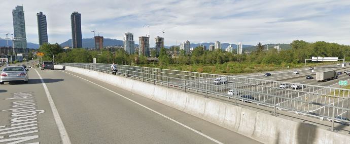
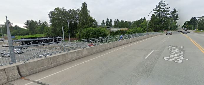
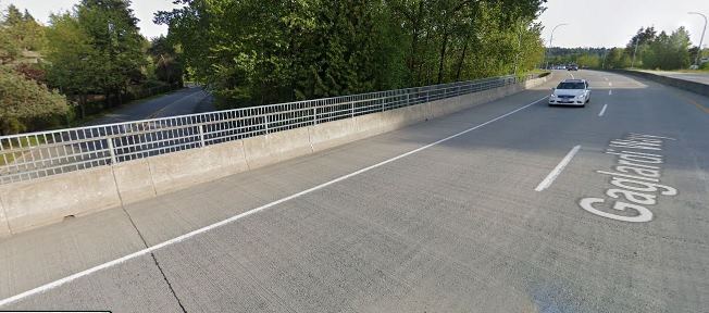
7th Ave upgrades The existing temporary protected bike lanes on 7th Ave between Moody Park and 5th Street are getting torn up right now as scheduled water main and service works are happening under that street. I am adamant that permanent protected AAA bike lanes need to replace them. This is the part of the established Crosstown Greenway that sees the most non-active traffic, and is probably the least comfortable part as it also sees its fair share of rush hour “rat runners”. The rest of the Crosstown Greenway could use some enhanced traffic calming, pavement re-allocation, and cyclist priority in some intersections, but it is this 300m section where true separated lanes are the only way all users will feel safe.

Connection to the High School Related to this, the new High School will be ready for students a year from now, and we have not done anything to assure that students of the school can safely connect to Crosstown Greenway and the adjacent neighbourhoods. The sidewalks along 6th and 8th are barely adequate now for the mass of students that pour out of the school when a bell rings, and the new site is going to be more constrained for parent drop-off and pickup, so the City needs to build safe connections. In my mind, that means separated bike route along 8th Street to Moody Park and widened sidewalks along 6th Street to 7th Ave, but I’ll leave the engineers and transportation planners to opine on what we need to build – I just want to get it built so that the new school is one that encourages students to walk, roll, bike, or scoot there.

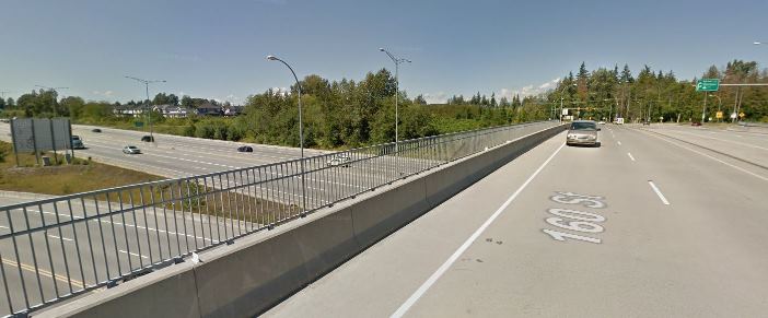
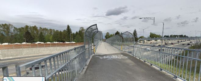
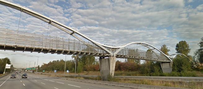
Agnes Greenway Bikeway Another major construction project in town will be starting the fall (hopefully), and is scheduled to be completed in 2023. At that time, the Pattullo, which is the second-worst crossing of a river in the Lower Mainland for bikes (Knight Street is worse, and the tunnel doesn’t count) will be replaced with what could be the best active transportation crossing in  the entire region – and it will see a concomitant increase in use. There is a lot of work being done in the City with the Ministry of Transportation to assure people landing in New West by bike or scooter have decent connections to the existing network. At the same time, we need to fix the crappy connections people trying to move east-west past the bridge now have to deal with. Agnes Street should be that connection for most of our Downtown, should provide proper AAA connections for all downtown residents to QayQayt Elementary, and can be the foundation for the much-needed-and-never-quite-done Downtown-to-Uptown grade-reduced route. This is as key to New Westminster’s Active Transportation future as the Burrard Street Bridge and Hornby Street bikeways were to Vancouver a decade ago. We need to see that vision, do it right, and make this the one gold-plated piece of bikeway infrastructure to hang all of our other dreams upon.

Uptown/Downtown connection Much like the Burrard Bridge example, the connections to the Agnes Bikeway are as important as the Bikeway itself. The Agnes Bikeway will only be transformational if it connects safely to the “heart” of downtown, which is and will continue to be the corner of Eighth Street and Columbia. It also needs to connect to a proper AAA route across Royal. HUB and ACTBiPed have talked at length about potential lower-grade routes from Columbia to Royal using the same thinking as “The Wiggle” in San Francisco, and a preferred route has been identified. However, the solution above and below Agnes are both going to require difficult engineering choices and potentially more difficult political ones.

Priorities set, that brings us to the bad part. Roads are expensive, and completely re-configuring how a road works is really expensive. Moving curbs, adjusting drainage, digging up the road, bringing in proper fill materials, asphalt, concrete, street lights, power poles, moving trees, epoxy paint – it all adds up. Right now cities like Vancouver budget about $10 Million per kilometre of separated bike route installation on existing roads. Long-term maintenance costs are likely lower than the driving-lanes-and-free-car-storage we have now on these routes, but there is no getting around that up-front ding to the budget.

Using the thumbnail estimate from Vancouver, the priorities above could total up to $20 Million, and my dream is to see this happen within the timeframe of our current $409 Million 5-year capital plan. About $155 Million of that is utility upgrades (water, sewer, and electrical), and another ~$100 Million is for the replacement of the Canada Games Pool and Centennial Community Centre. Somewhere in the remaining $150 Million we need to think about the cost of reducing the fossil fuel requirements of our fleet, pay for the current City Hall upgrades and the completion of the animal care facility in Q’Boro, among other projects. We have serious costs coming up – those $150 Million are already committed. And everyone who doesn’t love bikeways is going to hate them more when I suggest $20 Million over 5 years is about a 1% tax increase. I already get grief from some cohort in the City because I “talk too much about bikes”.

Fortunately, we are not alone. TransLink is investing in Active Transportation like never before, both in its role as the regional Transportation Authority, but also in recognizing that people are more likely to buy a ticket for SkyTrain if their 15-minute walk to SkyTrain is replaced with a safe and comfortable 5-minute bike ride. The Province recently released their Active Transportation Strategy, and at least one Federal Party in the upcoming election is hoping to see more federal money pointed at more sustainable transportation options as a campaign plank. Time to strike while the irons are hot.

In New Westminster, I’m going to be making the case that in the year 2019, the creation of safe AAA-standard active transportation infrastructure is not a “nice to have”, but is an essential part of our Climate Emergency response and the most notable missing piece of infrastructure in New Westminster’s quest to be the most accessible and livable city in the Lower Mainland.
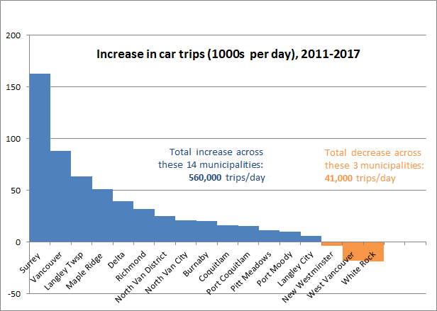
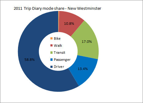
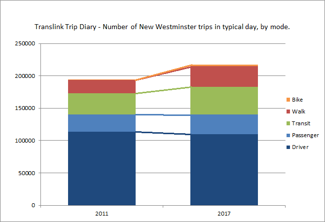
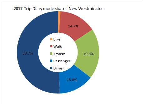
Ask Pat: Columbia & McBride

C D asks—

Just wondering if anything can be done to keep vehicles from running the red right turn light at Columbia Street and McBride. I walk this way everyday from Columbia Stn to Victoria Hill and it’s an enjoyable walk until I get there. Today a vehicle stopped only to be passed on the left by a vehicle that was behind the stopped vehicle. This is a daily occurrence just on my walk but I know this happens to other pedestrians and cyclists. Someone is going to be killed. Perhaps we can have a railway crossing arm that can come down?

I hate this crossing. I have railed about it in the past, and even wrote a blog post about it here back before I was elected and when I was little more sassy than I am now (there is a funny story in here about how an outgoing city councillor tried to use that blog post to scupper my first election campaign – but that’s a long digression). Even since then, there have been suggestions to fix the crossing and the signage and lighting has been changed to better address the confusion drivers seem to have. I do not think there will ever be a physical barrier installed in that spot and we (vulnerable road users) are just going to have to keep acting with an overabundance of caution until the entire thing is torn up and replaced along with the Pattullo Bridge replacement, which will be starting in the next year or so.

But why wait and not do something sooner? Because there is no obvious engineering solution that meets the current design code and is remotely affordable to do. People often suggest “what cost can you put on saving a life!?” when I say something like that, but I need to point out that this is one of more than a thousand intersections in the City, and by technical evaluation and statistical analysis it is not the most dangerous one for pedestrians by far. Those analyses are the way that staff decide which intersections to prioritize the (necessarily) limited budget of time and money into pedestrian improvements.

For example, the unmarked pedestrian crossing at 11th Street and Royal Avenue is current Pedestrian Enemy #1, so that block of Royal is currently being reconfigured to make it safer. There are a few other priority crossings, and staff are constantly updating the priority list and figuring out what interventions provide the best cost/benefit ratio. I’m not a transportation engineer, so I have to rely on their analysis when it comes to determining relative risk and how to prioritize to most effectively reduce pedestrian risk. Either that, or rely on anecdotal feelings about different intersections, but I think the former serves the community better.

I hate to say it, but “someone is going to get killed” is not a characteristic that separates McBride and Columbia from most urban intersections. Although New Westminster has been fortunate in the last couple of years and have not suffered a pedestrian fatality, the reality is that the ongoing trend towards improved driver and passenger safety is not reflected in the pedestrian realm. In Morissettian Irony, it is getting more dangerous to be a pedestrian around “safer” cars. There are several alleged reasons for this, but the most likely one being the increased size, mass, and power of vehicles with which vulnerable road users are meant to share the road. The only logical response to that is slower speed limits (working on it) and better design of intersections. But with 1,000+ intersections in a little City like New West, and many that need expensive interventions, that is not a quick fix.

I am more convinced every day that the real fix is more than engineering, though. This intersection is one where there is signage, lighting, a painted crosswalk, and yet some significant percentage of drivers just don’t follow the rules. Are they unaware, inattentive, or do they just not care? Likely, there is a Venn diagram where these three factors overlap, and no amount of engineering can fix all of these.

This has me more frustrated every day, and more wondering how we are going to get the real culture change we need to make our pedestrian spaces safe. We need to change the culture of drivers, of law enforcement, and of the entire community to address the fact people in cars are killing people who are not in cars, and that threat is making our cities less livable. We need to educate people about the actual risk they are posing to others every time they step into a car. And we need more active enforcement of the specific traffic laws that serve to protect vulnerable road users, because you apparently cannot engineer negligence and stupidity out of road users.

And worse, every time a City tries to build engineering to protect vulnerable road users, such as better crossings, longer cross signals, separated cycling infrastructure or curb bump-outs, we are bombarded by entitled drivers whinging about how pedestrians and cyclists don’t follow the rules (just read the comments). This despite clear evidence that the vast majority of pedestrian deaths are a result of the *driver* breaking the rules. This is a cultural problem rooted in entitlement, and I don’t know how to fix it.

To be clear: we need to acknowledge that the automobile is the single most dangerous technology we use in our everyday life, and stop being so blasé about the real risk and damage it causes. We also need to stop telling ourselves lies like automated electric cars are going to make life better – they demonstrably are not. But that is another entire blog post.

Intersections

I’m disappointed we didn’t get some of these stepped-up intersection speed cameras in New West. Speed cameras in intersections that can automatically ticket speeders are a good idea, one that can only be opposed by those who like to speed through intersections at illegal speeds, selfishly endangering everyone around them.

Why not New Wet? Apparently the intersections where these cameras were activated were those ranked highest in accident history and  speed issues. Perhaps the silver lining here is that this suggests our intersections are relatively safe by those measures compared to other areas in the Lower Mainland. Though I recognize just by saying that I am going to see comments on social media with people listing their least-favourite intersection. Mine is shown in the picture above.

But hopefully this is the just the first phase of the program, and we may see more cameras in the future. I would also hope that the next phases look not only at raw speed or 85th percentile or accident history, but we may expand the warrant analysis to emphasize intersections where vulnerable road users are more common. Yes, Accidents between speeding cars can be expensive, and often leads to injury or death. but a speeding car hitting a pedestrian is almost always fatal. While injuries and deaths of people inside cars is going down, injuries and deaths of pedestrians is going up. Technology like this can correct that trend.

On the good news side, New West has begun to make changes that were suggested by the Walkers Caucus last year, and are implementing a program of standardizing (and lengthening) the timing of pedestrian crossing light signals. Starting with the pedestrian-activated signals such as the one on Sixth Ave at 14th Street, which have already been adjusted to allow sufficient time for more people to cross safely. The ACTBiPed is also spending some time this year looking at the use of “Beg Buttons” in the City. Despite some lengthy critiques of these in Urbanist circles, there are places where pedestrian-controlled signals serve to make the pedestrian experience safer and more convenient, and there are places where they definitely prioritize car movement over pedestrian movement, in direct contrast to the priorities set out in our Master Transportation Plan. Teasing out these differences, and howto fix it, is an interesting topic, and one we hope to review and create some policy recommendations to Council.

But as you can see above, making our intersections safer and more comfortable for pedestrians is going to take more than signal timing and activation timing. This is why I support intersection camera, and further suggest we need to step up enforcement in the good old fashioned cop-with-a-ticketbook format if we are going to change drivers behaviour.

Jane’s Walk 2019

I’m leading a Jane’s Walk on Friday afternoon.

Apologies it needs to be on a Friday evening and not in the weekend true, but I have to be out of town Saturday/Sunday, and promised a certain Mary I would put a walk on, so here we go.

For those not in the know, Jane’s Walks are a series of walks held on the first weekend in May in places around the world in celebration of Jane Jacobs’ contributions to making Cities more livable. There are probably a dozen walks in New West this weekend, and I highly recommend you pick a few and meet some neighbours.

My walk is going to start at 5:30pm on Friday at Moody Park pool, and we will wander east along the path through Moody Park and then 7th Ave towards Glenbrook Middle School. I’m not sure how far we will get, but depending on the conversation, we will walk for 60 or 90 minutes before our perambulations lead some of us, inevitably, to a pub.

The topic of the conversation I want to have with whoever shows up will be framed by the contentious (?) temporary bike lane installations on 7th Ave between Moody Park and 6th Street. There is a lot to say about that particular stretch (I’ve said some of it here and here), but the bigger question is – What does a true AAA (“All Ages and Abilities”) bike route look like in New West? What compromises are we willing to make in regards to loss of green space, loss of traffic space, loss of parking, to see a AAA route built? Can a AAA bike route ever be one where bikes share space with cars, or is total separation needed? How do those needs shift between – a trail through a park, a route along a busy street, and a quiet residential street?

I need to emphasize, I don’t have a lot of answers here, other than what is informed by my “gut feeling” (which is no better than anyone else’s) about what is safe for cyclists. I would love if people discuss and think about these questions along the way, and try to discover for themselves what the friction points are that prevent rapid shift towards a full integrated and safe bike network. If you read my blog regularly (Hi Mom!), you may be interested in coming along. After all, what better way to spend a sunny evening walking through your neighbourhood, meeting some neighbours, and talking about ways to make your community safer and more livable?

C’mon out, bend a Councillor’s ear. Meet a neighbour. Take a walk. Love your City.