Connecting QB to the Quay

Amongst the great legendary structures of New Westminster, none has seen as much rumour and speculation as the mythical Bridge to Queensborough.

Not the Queensborough Bridge, but the allegedly announced, apparently planned for, and suspiciously funded but not-quite-yet-built fixed pedestrian crossing from the Quayside boardwalk to the east tip of Lulu Island, where the burgeoning neighbourhood of Port Royal is remaking the shape of Queensborough.

The reality of the bridge is that it is, indeed, “planned”. There is even a bit of money set aside for it. Any time I raise the issue with anyone at the City they assure me it will definitively be built. It is next on the list for DAC projects, done by 2016. Or 2017. Or 2019.

Now, for most people, a fixed piece of transportation infrastructure between the Quay an Queensborough seems like a great idea- who could be against it? It is like being against the Quayside Boardwalk, or the Central Valley Greenway, or the Seawall. The only people seemingly against it are those few familiar names who are against everything the City does. In a curious game of whack-a-mole problem-finding, they raised various complaints: it was too costly; it was an eyesore; it would destroy the “Submarine Park”.

These complaints were based on an early, and very preliminary, engineering assessment done on potential crossing options. This original plan was what you get when you give engineering consultants as free reign to build a bridge: it is big, expensive, and does the trick. A good starting point, but hardly the best of all possible solutions.

The reason we are even entertaining this idea to build a pedestrian bridge to Queensborough is due to DAC funding. The bridge is one of several identified projects that rose out of a slick deal cut between the City and the Provincial Government related to the old Riverboat Casino (which morphed onto the Starlight Casino). The background is complicated, but when the Province wanted to change the funding model for Casinos, New Westminster asked to be compensated for loss of potential income, and the Province agreed, but the money had to be earmarked for specific projects (could not be put into things like general revenue, or operating a ferry service, or paving Daniel Fontaine’s back alley). Amongst the earmarked projects were the newly-completed Queensborough Community Centre upgrades, other park amenities in Queensborough, and the Anvil Centre. Long version short, the City has a small pile of money from the Province they need to spend on building a pedestrian link to Queensborough.

This led to the 2009 report which provided early design ideas (including the drawing above), and led to a significant amount of whinging from the Quayside residents (although there is a general ambivalence about the project displayed in the Quayside Community Board minutes from 2009 when the project was announced).

That is not to say the original bridge plan was not without problems. The projected cost was much greater than the DAC funding available. A fixed crossing would need to be 22m above the water (~20m above the landings) due to requirements for maintaining a navigable channel for river traffic, which would potentially make for ungainly ramps of something like 400m length to accommodate pedestrians, wheelchairs, bikes, etc. Apparently, the Railway was not so chuffed about the idea of the City driving piles to support a 20-m-high bridge next to their 100-year-old pilings. The original landing spot for those ramps was where the current “Expo Submarine” park is located. Finally, the eyesore issue that if the City built the cheapest bridge possible, it was going to be ugly, and if they went for the grander vision, it might not be a vision shared by everyone (grandeur-wise, and cost-wise).

There were some creative alternatives floated. A ferry service, or a gondola. Maybe I will cover those in a future post, but extremely short version: show me the business case.

So it was exciting a couple of weeks ago when the City announced a new set of plans developed in partnership with the owners of the railway bridge: Southern Railway. The big difference this time around is the low elevation of the bridge, which makes life much easier to pedestrians and cyclists, but means the bridge must swing or draw to allow marine traffic to pass. A City Councillor I was chatting with last week even suggested it could be built to accommodate an ambulance for emergency use.

The problem? Who is going to open and close the bridge? The current train swing bridge stays “open” to marine traffic and is swung closed only when a train needs to pass. This would make a pedestrian crossing pretty much useless, so there is discussion of making the default “closed” to marine traffic, opened only when a boat has top pass. The Port would need to agree, as would the owners of the rail bridge. And someone would have to be on staff to flip the switch.
These are not minor details. SRY currently staffs the swing bridge and the one that connects Queensborough to Annacis Island adjacent to Derwent Way. That second bridge has the default position of “closed”, but that is just a minor channel approachable from both ends, not the entire North Arm of the Fraser River. If the City will be required to staff, or compensate SRY for the staffing, of a swing bridge, then the economics of this “less expensive” option may go away fairly quick.
Ultimately, I only hope the crossing will be reliable – one you can count on being there when you need it, and not unexpectedly opened for a hour at random times – because I see this bridge primarily as a transportation link, not a tourist draw or a nice place for a walk on the weekend (although it will be both of those, if done well!). Then it will be the link we have been missing up to now. 

Pattullo Consultation 2 – the options.

Now that the public consultation events have come to a close, and we have a week left to give TransLink our comments, I want to follow up my discussion of the Consultation Process with my reactions to the options provided.
So as to not bury the lede, and to allow for great summarizing and generalization, I am going to list the options provided by TransLink in the consultation documents grouped into four categories based completely on my own (as informed as possible) opinions: Optimal, Sub-optimal, Bad, and Untenable.
Optimal: If I was voting, this is where I would cast my ballot.
Options #4 and #5.
Fixing the bridge we have seems the simplest, most cost-effective solution, and it can easily be financed through a moderate toll, similar to the cost premium for crossing a “Zone” on any other TransLink infrastructure.These options (and I prefer the three-lane counterflow to provide better comfort and lower wear for road users) meets all of the listed objectives. It fixes the core problem (an old bridge) while respecting local and regional planning goals and existing transportation networks. Meanwhile, the historically significant structure can be preserved to grace our skyline for another generation, and safety for cyclists and pedestrians can be improved.
The bonus in these “difficult economic times” is that this is the least expensive option, and can easily be funded through modest tolls. Back-of-the-envelope estimates suggest that the $3 tolls of Port Mann are not necessary here, but a toll pegged to the zone-crossing premium of the adjacent SkyBridge (currently $1.25) would be more than enough to cover the repair and maintenance costs. The toll would be enough to disincentivize avoiding the Port Mann, but not so high as to be a burden to regular users. It may even help encourage the use of the alternative next door.
Sub-optimal: Not ideal, but I could probably live with it and not whinge too much. 
Options #2, #3, #19.

All pictures zoom if ya click them!

All of these options keep the Pattullo standing, and that satisfies one of my major criteria: protecting the heritage of the structure. Each is less perfect than the optimal choices in different ways.

The first two don’t seem to provide any real benefit over the Optimal choices. I cannot imagine this region spending $300 Million on a single piece of bicycle and pedestrian infrastructure these days, when a bike lane in Vancouver that costs less to install than a single left-turn bay for cars on an adjacent street is used as evidence for a “war on cars”. This is politically untenable, and probably just disruptive enough to transportation systems already established that it doesn’t really serve the purpose. There is nothing a 2-lane Pattullo provides us better than three-lane Pattullo, so these are just lesser versions of a good idea.
Option #19 has been the source of much talk, speculation, dreaming, and idolation since the consultations began. I have never been a big fan of the Sapperton Bar crossing (for reasons outlined below), but have to admit, when I saw this option presented by TransLink, I started to reconsider, mostly because the speculated cost of $1.5 Billion is much, much lower than I anticipated for a crossing on one of the wider parts of the River. This makes the cost recoverable from tolls on the two bridges (the new one, and the refurbished 2-lane Pattullo).
The obvious upside is that his option may facilitate the closing of the Pattullo to trucks, and provide the most cost-effective solution to the problem that the “Stormont Solution” purports to solve: getting vehicles from Surrey to Highway 1 ASAP, at a fraction of the cost of a 4-km tunnel through New Westminster.
My problems with this option (besides suspicion around the projected cost) are built around the fear that this is really a “NIMBY” solution that, once again, adds to road capacity when that is not the problem we are trying to solve. Nothing in the problem set for the Pattullo supports building another bridge to the east. We also don’t know if the residents of Bridgeview or Coquitlam want this new Highway connection in their neighbourhoods. The connections on the north side are especially problematic- are we envisioning a road through the Brunette Industrial Area connecting at Braid (spanning the rail yard), or something over by the King Edward Overpass (which would be impossible to connect to Highway 1)? It was suggested that the projected cost of this option would only take the new bridge to United Boulevard, which is actually no-where, except a congested narrow 4-lane with access to Lee Valley.
Mark me down as intrigued, but not informed enough to actually feel positive about this one.
Bad: Just a bad idea, and hard to see how to make it good. 
Options #1, #6, #14, #15, #16, #17, #18, #20.

The first option here – the removal of the bridge – is a bit of a dream for some in New Westminster, but I think fails to acknowledge both the importance of the established transportation networks, and the importance of the Pattullo as a heritage structure. I like the bridge on our skyline, I like crossing it on foot and on my bike and even, occasionally, by car. I would be sad to see it go.

Option #6 is for a new 4-lane bridge, which has the unique combination of making the situation no better than it is now traffic- and transportation-wise, but losing the heritage structure at a much higher cost than the refurbishment option. So not individually terrible; just a combination of so many sub-optimals that the sum is bad.
#14, #15, #16 and #20 all rely on the Sapperton Bar crossing being built, which is actually a pretty crappy idea. It takes the Surrey-Coquitlam version (with all of it’s uncertainties) and adds a road connecting to a tunnel under Sapperton – for no apparent reason or understanding of the neighbourhoods it is launching into – to presumably access a non-existent (and un-budgeted) Stormont connection, yet still doubles the cost. I cannot imagine why.
#17 is lesser than #19, for not much less cost, except that we no longer have a Pattullo at all. Meh. Meanwhile #18 has the same critical flaw as #2 in that no-one is going to spend something like $300 million to refurbish the Pattullo for bicycles and pedestrians only in MetroVancouver in 2013 when we cannot even scrape together a couple of million to fix the BC Parkway. Give me $300 Million for bike infrastructure, I can spend it much better than this.
Untenable: They just threw these in here to see if we were paying attention.
Options #7, #8, #9, #10, #11, #12, #13, #21, #22, #23, #24, and #25.

The first three options bring progressively bigger bridges into the location of the Pattullo Bridge. It was these ideas that brought us all out to last year’s consultations, and no defensible case was made for them last year, which is why we are all here a year later reviewing better ideas. This idea has not improved with age.

The four sub-river tunnel options are dead on arrival. Without the “branch”, and with no specific idea about what happens along McBride, it provides no advantage over the bigger Bridge options, but at 2-3 times the cost. With the “branch” along Royal, the cost rises well over $4 Billion (an unlikely sum for TransLink to cobble together), all to move one inevitable traffic pinch point from the South end of McBride to the North end of McBride, and to increase the congestion on Stewardson. It is a road-builders dream that spends a lot of taxpayers money but makes worse most of the problems it claims to solve. I’ve said it before: tunnels are for trains, not cars and trucks. 
#21 and #22 have all the bad parts of #14 through #20, but with increased traffic and cost.

The final 3 options are all related to a new crossing way over by “Tree Island” – a misnomer peninsula that currently hosts a steel wire factory and will soon be home to a TransLink bus parking facility – to connect Richmond to Burnaby. Richmond has been clear that they are opposed to this idea, and no-one at TransLink was really clear how this in any way related to the Pattullo Bridge – it surely does not replace any capacity needs at Pattullo, doesn’t directly address the “old bridge problem”, nor does it cross most of the Fraser River. This is so off topic, it is just a distraction not worth discussion.   

That’s it folks, this is what we have to work with. You have another week or so to get your opinions to TransLink by going to this site. Just for the fun of it, you can also tell Surrey what you think by going to this site.
Good luck.

Pattullo Consultations & Cautious Optimism

Call me cautiously optimistic.

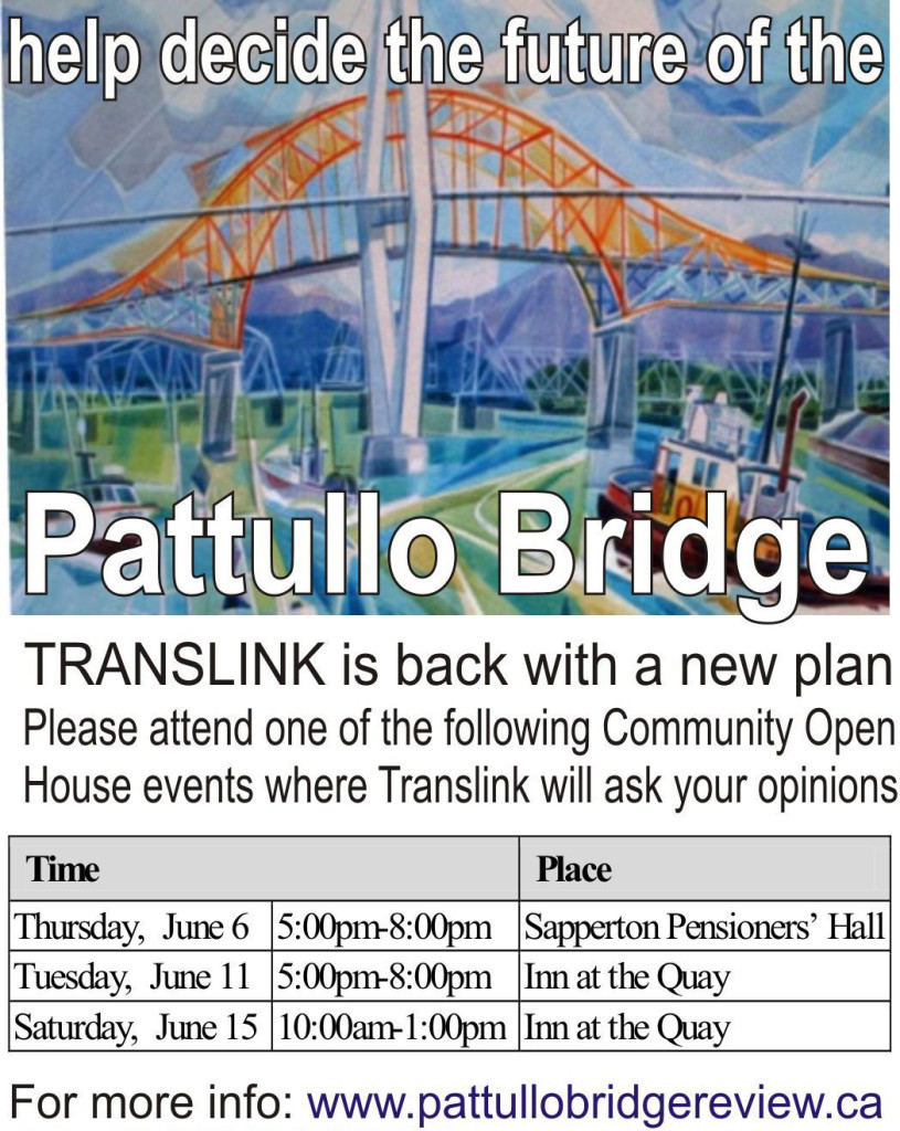
As promised, TransLink is back in town, talking Pattullo. I have attended a small-group talk on June 4th, and dropped into the open house on the 6th to hear the public feedback part of the event. I have also poured through the presentation materials.

Interesting that this new round of consultation is starting in New Westminster only a week after TransLink moved their office to the Brewery District, not two blocks from the Sapperton Pensioners Hall where the meetings were being held. This is no doubt a coincidence, but damn convenient for staff.

What is not a coincidence is that much of what we are seeing at this consultation looks very much like what the New Westminster community was asking for a year ago when the first attempt at consultation took place in New Westminster. At the time, New West was clearly not happy with the several iterations of 6-lane Pattullo offered, or with the lack of discussion of higher-level policy directives that were pushing us towards placing a bigger bridge within an already-constricted road system.

There is a lot of information provided in the consultation materials this time around, and I want to give some of it time to breathe, so this will be a multi-stage blog as I try to wrap my head around the various topics and options. Classify everything that follows as “first impressions”.

Without getting too deep into the options, there is much in the consultation documentation that should make New Westminster happy.

First look at Page 5 of the booklet where TransLink presents the problem statement:

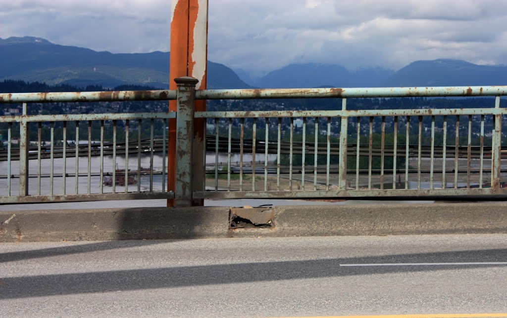
“The Pattullo Bridge may not survive a moderate earthquake or ship collision, the piers are at risk of being undermined by river scour and many bridge components have surpassed their useful life”

Right up front, this is a vast improvement from the earlier consultation, because (as I suggested last year) TransLink is no longer talking about solving a traffic capacity problem, they are talking about solving an old bridge problem. This is the biggest reason why there is a much broader range of solutions being presented to deal with the problem, including the fundamental idea that fixing the bridge we have is viable.

Beyond the problem statement, there is a list of other issues that are to be considered while seeking an approach to solve the old bridge problem:

1. The Pattullo Bridge does not meet current roadway design guidelines, including for lane widths and curvature, potentially contributing to collisions.
2. Pattullo Bridge facilities, such as sidewalks and barriers, and connections for pedestrians and cyclists, are inadequate and do not provide sufficient protection from traffic.
3. During rush hours, travel demand on the roads leading to the Pattullo Bridge results in queuing and unreliable travel times for the movement of people, goods and services.
4. Current traffic (including truck) volumes affect the liveability of adjacent communities due to air quality, noise and resulting health impacts, as well as due to neighbourhood traffic infiltration.

Again these messages are very different than last year. Only point 3 acknowledges current traffic volumes, and point 4 correctly characterizes the biggest issue with traffic volumes is their negative impact on livability.

This problem set simply does not add up to adding lanes within the Pattullo Bridge corridor.

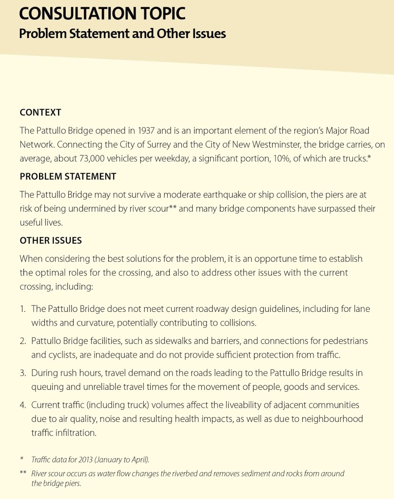
Looking at the traffic discussion on Page 7 provides some interesting context to the recent changes in traffic patterns. Notably, traffic on the Pattullo is not, as most would contend, worse than it was a decade ago, or even 20 years ago.

TransLink graphic, click to zoom in. 

Perhaps more interesting is the preliminary traffic data showing the impact of the new Port Mann tolls and connection to the South Fraser Perimeter Road. Anecdotally, traffic has been worse in New West since those changes in December, and data does support a slight increase in numbers. Although the data is preliminary, there has been a 4% increase in traffic of all types (both on weekdays and the weekend). Truck traffic has only increased 3% on weekdays and is apparently unchanged on the weekend.

This doesn’t seem like much, but 200 extra trucks a day might be noticeable if they are all going the same way after crossing the bridge (you have to think during business hours that is about one extra truck every 5 minutes).

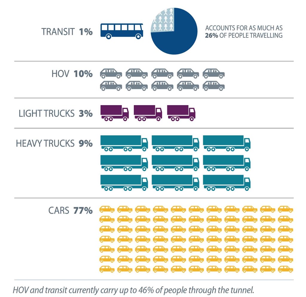
Still, the numbers reinforce what the real traffic load on the Pattullo is: not trucks carrying lettuce and cheese to New Westminster stores, but cars moving people though town. 92% of weekday traffic and 96% of weekend traffic is cars. Keep those numbers in mind when anyone talks about alleviating traffic congestion by building truck-only lanes.

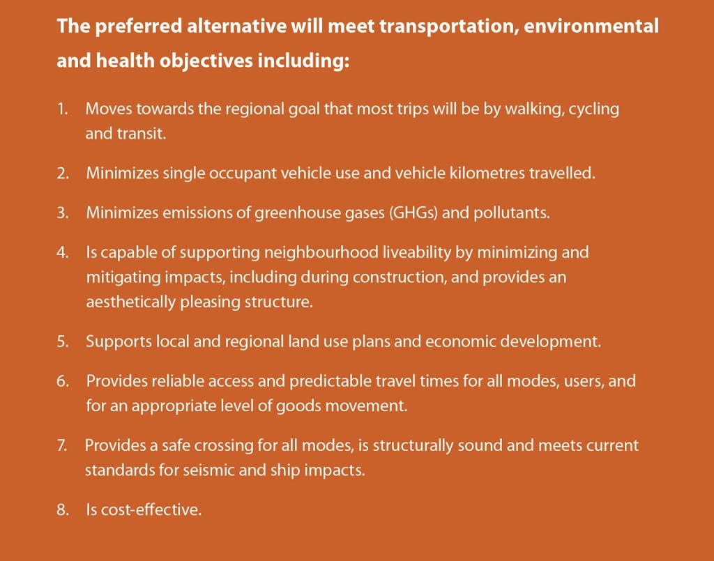
Probably the most important new info in this package is on page 11- the statement of Objectives for the review, because these will be the measuring stick used to measure the various options. The option that best fits these eight objectives should be the one chosen, if the evaluation is a good one.

So let’s look at them in turn:

1. Moves towards the regional goal that most trips will be by walking, cycling
and transit.

This objective is straight out of the Regional Growth Strategy, TransLink’s Transport 2040 long-term planning document, and the goals of the draft City of New Westminster Master Transportation Plan. It also coincides with several Surrey long-term policy documents (Cycling Plan, Walking Plan, Sustainability Charter) and the Provincial Cycling Policy and Climate Action Plan. So easy to see where this is coming from.

2. Minimizes single occupant vehicle use and vehicle kilometres travelled.

Again, this objective fits all of the above plans, and speaks directly against any plan of expanded road capacity for the Pattullo.

3. Minimizes emissions of greenhouse gases (GHGs) and pollutants.

Interesting. People taking transit, cycling, or walking produce much less GHG and pollutants than drivers, including trucks. Moving freight by rail instead of truck reduces GHG and pollutants. Building transit infrastructure South of the Fraser will reduce GHG and pollutants much more than any road-building project crossing the River will. Keeping the old bridge will produce less pollutants and GHG than building a new one, just in relation to the amount concrete that would be saved.

4. Is capable of supporting neighbourhood liveability by minimizing and
mitigating impacts, including during construction, and provides an aesthetically pleasing structure.

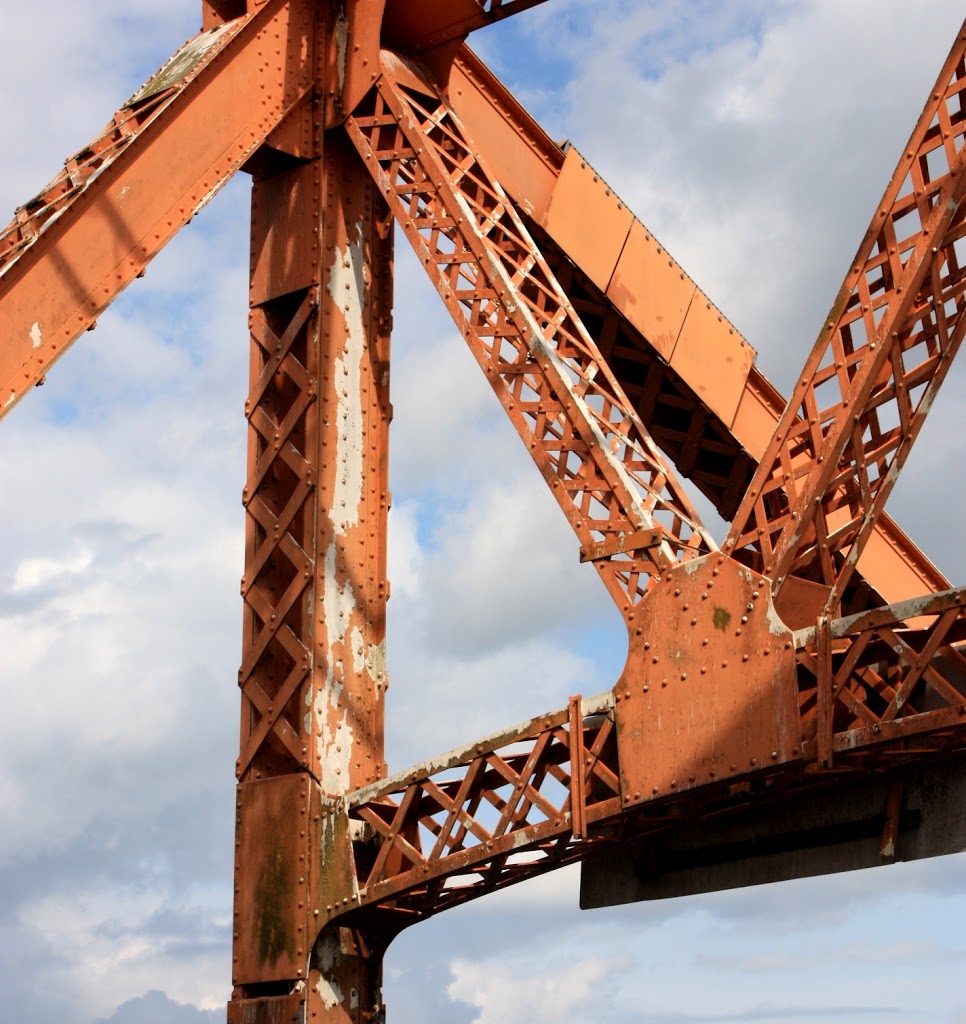
Here is a big one that should make New Westminster happy. Livability of the surrounding community is taken into account. Another strike against bigger road capacity. Unless all of that traffic goes into the mythical McBride-Stormont Tunnel, but we will address that later. Aesthetically pleasing might be a challenge- I think the existing bridge looks great, but needs a coat of paint. “Pleasing” is pretty subjective, though.

5. Supports local and regional land use plans and economic development.

Once again, the regional landuse plan and local community plans for New Westminster and the portion of Surrey right across the bridge, are for compact, dense, urban centres where alternative transportation modes dominate.

6. Provides reliable access and predictable travel times for all modes, users, and
for an appropriate level of goods movement.

Some interesting wiggle words here. “Predictable” travel times don’t mean reduced travel times. A fully congested bridge is predictable, a bridge where traffic moves at 50km/h is predictable. A closed bridge is predictable. A bridge where traffic sometimes goes 50km/h and sometimes goes 80km/h, and is subject to accidents and poor visibility and crumbling bad pavement produces unpredictability. Transit and bicycles? Super predictable.

7. Provides a safe crossing for all modes, is structurally sound and meets current
standards for seismic and ship impacts.

No-one can argue against that.

8. Is cost-effective.

No-one can argue against that, except that there is no description of what they mean by the term. As TransLink has no money, one has to presume they are going to have to toll this bridge to pay for it. At the consultation I attended, it was strongly implied that tolls were the most likely option to finance the bridge, but they were not discounting the potential for contributions from senior governments.

For some reason, I doubt there will be a referendum to decide how to pay for this bridge (like was floated during the election as a proposal to find funding sources for TransLink operations). However, the question of Tolls is not secondary to this consultation, many of the goals around GHGs, improved livability, and predictability of travel times can be effectively addressed through Transportation Demand Management, including road pricing. The needs of this crossing, and other crossings in the region, will depend on whether they are tolled or not.

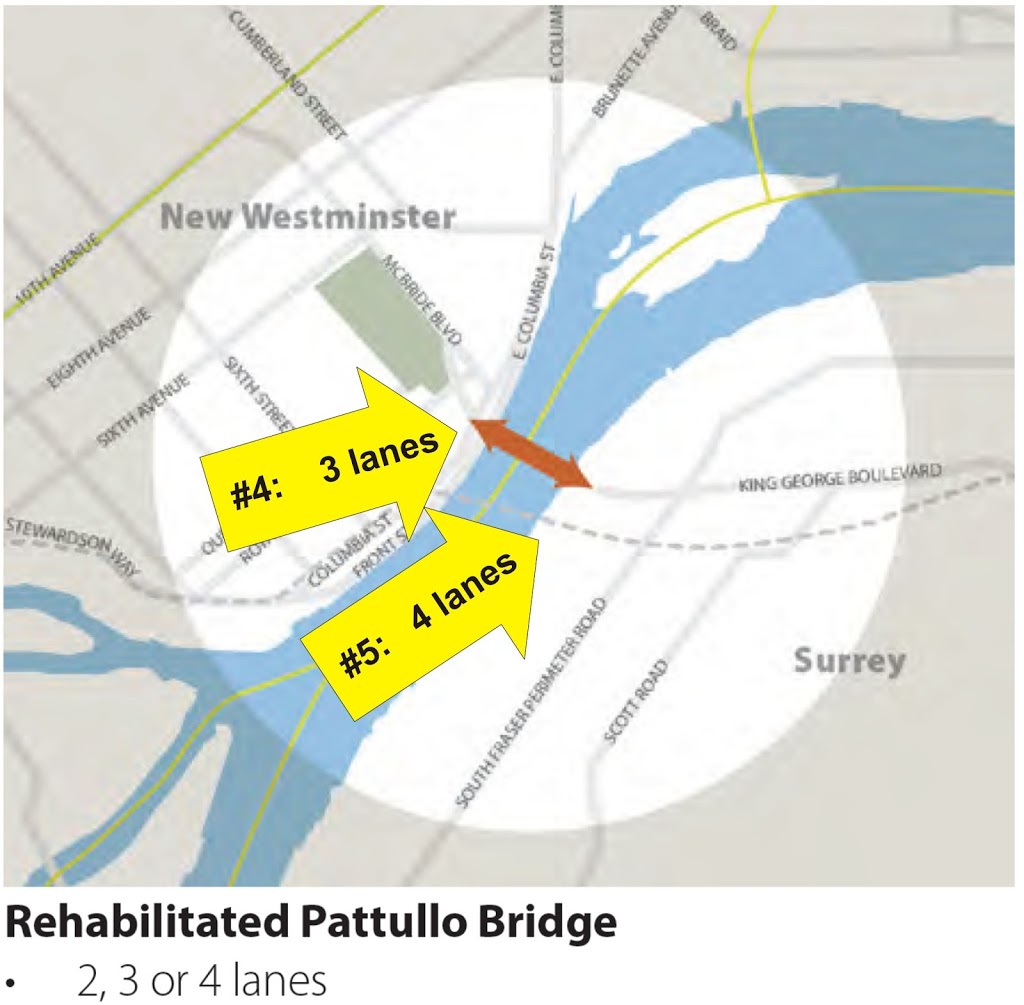
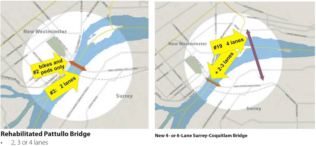
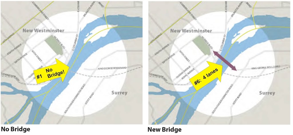
Ultimately, I am for the least-expensive option that maintains a link while improving alternative transportation access. Clearly, fixing the existing bridge is a viable and affordable option. At the other end of the spectrum cost-wise are the various tunnel modes. As I’ve said before, tunnels are great for trains, but for cars full of people, they are monumentally expensive. But I will save a complicated options analysis until another post.

Short version: This is what we asked for, folks. Last year when New Westminster showed up in force at the consultations and asked TransLink to go away and come back with something better, this is what that something better looked like. We are early in the process this time around, but looking at the problem formulation and evaluation criteria being applied, it is hard to see how anything larger than a 4-lane Pattullo (refurbished or new) could be accepted as the best approach.

If you have questions or opinions, your last chance to take them to TransLink in person is on Saturday at the Inn at the Quay. The on-line parts of the consultation will be running for a couple of weeks yet, and there have been reports of phone polls happening in New Westminster. There are lots of opportunities for you to take part here.

Is there enough shame in being the “Second Worst Road”?

It didn’t start last month. I have lamented the BC Parkway for quite some time.

There was a time, back in the late 1980’s when I lived on Royal Avenue and worked in a warehouse just off Royal Oak, and I would ride my bike along the Parkway to get to work. Back then, it was great – an actual road just for bikes and pedestrians! In hindsight, the connections and some of the route choices were a little sketchy, but that is only with the benefit of hindsight. For ca. 1988, it was a kick-ass bikeway.

Twenty-five years later, I live two blocks from that crappy apartment I shared with my brother on Royal, and the lovely Ms.NWimby has a new job in Downtown Vancouver. A fair-weather bike commuter (the Skytrain ride is only 20 minutes!), we pulled out a bike map and tried to figure the route to her new job for those sunny days when the bike is calling.

We both immediately ignore the BC Parkway and look for alternates: CVG? (stays at low elevation, but seems a long way around New West). Cariboo to Adanac? (nice, but a little out of the way- and killer hill on the way home) Tenth to London to Griffiths to Rumble to Patterson to Moscrop to Smith to 22nd to Slocan to Charles to…(ugh).

Nope, the near-straight line, on a gentle slope (as it used to be a rail grade) that makes the most sense is the BC Parkway. If only it was safe or lived up to its promise. Instead, 28 years of local re-development, new roads, and failing pavement (along with a few original design elements that look hysterically outdated now) have made the route one to avoid for most cyclists.

So now that my little campaign to get the BC Parkway noticed is having its little media push– the whinging has gone as far as it can- so what to do?

First off: Jurisdictions. The BC Parkway is almost completely on TransLink property, and is ostensibly TransLink’s responsibility. Portions of it, however, are clearly on the property of and subject to the decision-making of, the three municipalities through which it passes. Any comprehensive refurbishment will require partnership between TransLink and the Transportation Departments in those Cities.

It’s not like TransLink doesn’t know the Parkway needs help. Back in 2008 there was an assessment report prepared for TransLink. I quote from that report:

Over the years, the dual trail design has proven to be less popular with BC Parkway users while land use adjacent to the trail has intensified, resulting in the paved portion of the BC Parkway becoming a heavily used, mixed-use facility that is generally narrower than the Transportation Association of Canada’s guideline of 4.0 metres for a shared, bi-directional urban path. Intense use of this inadequate facility and lack of proper maintenance has lead to its physical deterioration. The route is indirect in some locations and wayfinding is poor, making navigation difficult, particularly where the route transitions between the off-street pathway and urban streets. Efforts to upgrade sections of the Parkway have resulted in disjointed designs and application of the TAC standards that are not contiguous with other sections of the Parkway.

Yeah, that’s what I said!

Stakeholder meetings and concept plans were drawn up to fix the problems in 2009. Then what happened? Two things come to mind: the Canada Line, and the entire TransLink funding crisis.

The Canada Line Bridge is a great piece of cycling infrastructure (worthy of its own blog post, which I will do at some point soon), but few know it wasn’t actually part of the original Canada Line plan. Canada Line was not, strictly speaking, built by TransLink, but was a PPP dedicated to getting the damn thing in the ground before the Olympics started. The idea of putting a pedestrian-bicycle path on the side of the bridge came from strong lobbying by cycling groups in the City, and concomitant support from Richmond and Vancouver Councils. However, strapping the path to the side of the bridge was not part of the original plan, so the concessionaire building the Canada Line was certainly not going to pay for it, leaving TransLink holding the bag. The only solution was for TransLink to take it out of the bicycle infrastructure budget.

Notably, the cost of attaching the pathway to the Bridge (about $10 Million) was only 0.6% of the Canada Line budget, but represented 200% of TransLink’s annual bicycle infrastructure budget. So for two years, little other bicycle infrastructure got built by TransLink.

After the happy glow from their massive success moving people during the Olympics wore off, TransLink somehow became the whipping boy of the media and most levels of Government – for reasons poorly understood by anyone. I have gone on at length about this in the past, but short version: everyone has decided it is time to stop paying for the transit system at the same time other sources of revenue have been failing (some the fault of TransLink’s own success). The bicycle program budget is alternating between deep cuts and complete defunding. In this financial climate – when TransLink is actually cutting bus service as the region continues to grow – it appears the BC Parkway was simply not high enough on the priority list to see the plans realized.

I recognize I am only pointing out the problem, not what to do about it. I wish I knew.

The first obvious answer is to fund TransLink. There seemed some real promise that this was going to happen before the last election, but the surprise winner seems to think tax collected for Public Transit is the one type of tax that requires a referendum! There is no doubt, based on TransLink’s plans and policies, that they want to have safe, accessible bike routes as part of the integrated regional transportation system, especially ones that connect to their stations and bike lockers. People who ride bikes to SkyTrain stations buy tickets on SkyTrain, the business case is obvious. They just can’t afford to prioritize this right now.

So that leaves the Cities, Vancouver, Burnaby and New West all have budgets for cycling and pedestrian infrastructure, and all are challenged in setting priorities when transfers from senior Governments increasingly come in the form of responsibility, not compensation. For the BC Parkway to be improved, the Cities will need to take them on as a “Pet Project”, and through direct infrastructure spending or finding innovative funding strategies (remember, 7-11 and Molson paid for the first iteration of the Parkway) they will need to come to TransLink with some kind of matching fund. Given an opportunity to “share the cost” will be the only way that TransLink is likely to push this route to the top of the priority list when so strapped for funds.

Ultimately, the BCAA “Worst Roads” campaign is about shaming whomever owns the “Worst Road” (Municipality, Regional Government, or Ministry of Transportation) into in prioritizing the identified roads in their medium-term planning. Note that last year’s #1 finisher also finished first again this year- despite the $19 Million this particular “Pet Project” has recently received. Finisher #3 this year is also in the middle of a multi-million dollar planning process to find what will no doubt be a billion dollar solution. So maybe shame works.

But I don’t want to shame TransLink – I think they know the problem, and they wish they could do something about it. The shame here should go back to the multiple levels of government who have consistently failed to fund alternative transportation programs with the fervour used to provide smooth driving surfaces for cars.

Fix it.

Not sure how you haven’t heard- but TransLink is back in New Westminster to talk about the Pattullo Bridge. Consultation meetings start this week, and go on for most of June. You really should think about attending one. Or more.

This got me thinking that it was this time last year that Pattullo Consultation Part 1 occurred. It was 13 months ago that I wrote this long Blog Post about how the Pattullo was showing signs of neglect. Short version: the Pattullo is an old steel structure, and like all old steel structures from the Eiffel Tower to my Honda, they will last nearly forever if properly maintained, but will turn to dust in a flash if neglected. In that post, I showed some pictures of the bridge, demonstrating that TransLink is leaning towards the dust-making approach to maintenance.

So it being a year on, I went by the Pattullo Bridge today to see if there was any sign of the alleged $3 Million a year TransLink once claimed they spent on maintaining the Pattullo. Just for fun, I tried, as best I could, to repeat the photos I took a year ago. So here are the before-and-after photos:

No change here. 
Pretty much the same rust
Paint continuing to peel
This catch basin still jammed, with some of the same debris!
I guess wheel-damaging potholes are a bigger priority than failing bridge structures
Admittedly, it looks like a couple of the more potentially tetanus-causing pillars had
their jagged metal sawed off, and a bit of new paint applied to them. 
It’s been a slow year for Plaque-taggers.
…and for those concerned, the plants in the trusswork are still doing fine!

I took a few more pictures this time, just for the fun of it:

There is still a healthy mix of rusted-through railings and pillars, even if a few have been painted.
Along with new potholes, this one demonstrating what happens when a catchbasin
is blocked for too long, and the water needs somewhere to go.

The point I want to make here is not that the bridge is rusty and unsafe; it is certainly rusty, but TransLink assures us it is safe (but ominously won’t be for long). The point is that TransLink is, for whatever reason, still failing to do the maintenance that might keep it safe.

The Pattullo is an historic structure, the most iconic structure on New Westminster’s skyline for 75 years. It is every bit as historically significant as its contemporaries at the First Narrows of Burrard Inlet and Sydney Harbour. Allowing this historic structure and vital transportation link to degrade to its current state is shameful, and an irresponsible way to manage public infrastructure. It is time to fix it.

That is the position I am taking into TransLink’s consultations, one that can be summed up in two words: “Fix it”

Fix it: We don’t want or need a new bridge, or a wider bridge, or more bridge or the bridge to be moved or removed. The bridge serves a purpose, and can continue to for the next generation, but it needs to be fixed.

Fix it: The bridge is iconic, historic, and an important part of the heritage of the City and the region. It must be preserved, protected, and celebrated.

Fix it: The bridge can serve its users by replacing the sidewalk with a lighter, wider structure (similar to the approach on the Queensborough), and by reducing the driving lanes to 3 with a central counter-flow, much like the Lions Gate.

Fix it: The bridge suffers (like most of TransLink’s infrastructure) from a profound lack of funding for a transportation authority in a rapidly-growing region. The funding model for TransLink needs to be fixed.

Fix it: Transit in Surrey is woefully underdeveloped and underfunded, forcing residents to be overly dependant on this bridge to get places. The region’s transportation options are broken – fix it!

Fix it: yes, TransLink has provided us a compelling list of the current bridge’s problems, but they have not talked about how they will fix them. Time to get started.

C’mon TransLink, we are all in the same camp here. Let’s agree on a plan, let’s lobby the senior governments to get you the funds you need, and let’s fix the damn bridge.

Pattullo Consultation Redux

Some were wondering what I was doing on Saturday, walking the sidewalks during Uptown Live and the Hyack Parade dressed as a bridge.

I was handing these out:

Yes, TransLink is coming back to New Westminster to talk some more about the future of the Pattullo Bridge. This is a new phase of consultation, no doubt timed to come right on the heels of the Provincial Election. This is actually good news, not something to lament.

Last time TransLink came around these parts talking about the Pattullo to the public, there were two reactions: Almost complete indifference from Surrey, and vociferous concern from New Westminster. The plan presented at that time were for a bridge that both increased the traffic load on New Westminster, while failing to acknowledge the importance of the existing structure to New Westminster’s historical and cultural landscape. The good news is that TransLink got the message, and decided to step back and re-evaluate its approach to the aging Pattullo.

Some people have asked the NWEP members if we are going to hold a “rally” related to these consultations, as we did last time. I cannot speak for the NWEP (Although there is a members meeting tomorrow night where this will no doubt be discussed), but I suspect that the answer will be no. At the successful rally last year, the NWEP and the citizens of New Westminster were asking for better idea: for TransLink to come back with a more comprehensive review of the options for the bridge, everything from replacement to moving it to refurbishing it to just removing it altogether. It appears that is what TransLink has done. Now is time for us, New Westminster, to show up at one or more of the Open House events being held in June and first listen – then think – then provide comment. Right now TransLink is listening, so there is no reason to shout. With this in mind, all I was doing on Saturday was telling people there will be meetings in June on the future of the Pattullo, and we want people to show up.

More information on the Meeting times and locations is available here.

Mark your calendars, there are actually 6 meetings (3 in New West, 3 in Surrey), and if the Surrey ones work better for you- attend those! Last time we did this, the Surrey meetings were sparsely attended, so it might be easier to bend some ears there than in New West. The most important thing is that you get out to one or more of the meetings and get your comments to TransLink. I’ve said it before, I’ll say it again, Participatory Democracy is those that show up.

My Nominee for the Worst Road in BC

MORE UPDATES BELOW (May 22)

Every year, BC’s Car Nobbling Council the BC Automobile Association has a little campaign to shame municipalities into giving more money to the BC Road Builders. This “news” is dutifully lapped up by the popular media, and many fingers are wagged at Cities for not maintaining their infrastructure.

It is good media, good advertising for the BCAA, and after the rush of the contest cools down, AM radio goes back to complaining about high taxes and the evils of socialism. No-one ever mentions that roads are, de facto, a socialist enterprise. Government pooling money from taxpayers and spending it building something for the common good – roads are the very model of socialism. But I digress.

This year, I want to nominate a candidate. There is one route that I have been lamenting for a few years, and it never seems to get the attention it needs. It is 9 kilometres of undulating, root-cracked, potholed, uneven, poorly marked, inconsistent, horribly maintained, and (IMHO) unsafe pavement connecting the New Westminster Quayside boardwalk to Burnaby’s Central Park. It sees a lot of traffic, provides an important arterial corridor connecting numerous other routes, and it has seen little more than a few asphalt patches in 27 years.

Yes, I am talking about the BC Parkway, or to give credit to sponsors from 27 years ago, the combined “John Molson Way” walking path and “7-Eleven Bike Route”.

Let me take you back to the heady days of Expo86. The theme was “World in Motion” and transportation was central to most exhibits. When the SkyTrain was built out to New Westminster to bring Vancouver into the 70’s, transportation-wise, the entire line was paralleled by the BC Parkway. I’m not sure why Molson decided to sponsor a walking path, but for a decade around that time 7-Eleven sponsored a major international cycling team. In fact, the only Canadians to ever wear the Yellow Jersey in the Tour de France did it for Team 7-Eleven: Alex Stieda in 1986 and Steve Bauer in 1990. (Bauer also wore yellow in 1988, riding for Weinmann – La Suisse the year Greg Lemond was busy being shot, but I’m geeking out now). At the time, they also provided me countless post-ride Slurpees. No-one has to convince me of 7-Eleven’s credibility when it comes to support for cycling.

The BC Parkway represented Greater Vancouver’s first multi-community-connecting active transport route – our first “Greenway” that didn’t wrap around Stanley Park – but time has not been good to it.

In the intervening 27 years, the BC Parkway through Burnaby and New Westminster has seen a lot of development. Metrotown, Edmonds, Downtown New Westminster and the Quayside have all blown up since 1986. With all the change, some connections on the BC Parkway have been improved, some have been severed. The pavement has degraded, the crossings have become hazardous, the sight lines destroyed and the route chopped up. The asphalt in place is so bad that tree roots have pushed right through- and are being eroded by bike tires! What other road in the province features tree roots being held back by tires? This is a shameful state for our region’s first real integrated municipality-spanning Greenway!

So, please, I implore you – go to the BCAA website and vote for “BC Parkway, Vancouver ” for being “Unsafe for Cyclists and Pedestrians“. You cannot select it with the map, but enter “BC Parkway” in the search, and if it doesn’t find it, choose the highlighted “following form” text to the left. It takes 30 seconds to use the pull-down menus, and if we enter it enough, they may need to acknowledge us. They have acknowledged us! We are now in the top 10 list of worst roads, so you can enter “BC Parkway” in the search and vote with one push of the button! Tell your friends, tell your neighbours, tell your mom, tell cyclists you see rattling their teeth or getting lost on the BC Parkway, tell pedestrians tired of being treated like pylons on the BC Parkway! If you only vote once this month, do it at the BCAA website!

May 22 UPDATE: You can now Choose “BC Parkway Burnaby” or “BC Parkway Vancouver” – and at this point, I don’t care which you choose, as they are both in the Top 10! All the pictures below are form the Burnaby and New Westminster portion, but applies as well to much of the Vancouver portion. Oh, and the BCAA has subtley changed their marketing around this, to make it apparent that they are OK with a bikeway winning! So get one more vote in – only 3 days to go!

In case you need more convincing, here are some highlights of my tour yesterday from Central Park to New Westminster along the Parkway:

The new parts through Central Park are actually quite pleasant!
First problem at Patterson Station. No traffic controls. Do I dodge pedestrians
on the narrow sidewalk / bus stop / newspaper kiosk, or do I go against
 the Do Not Enter sign through the bus lane? 
Sometimes I’m separated from the sidewalk, sometimes not. What is
a pedestrian to think? 
I guess I could go through the bollards onto the narrow sidewalk to avoid
the pedestrians, but there are signs and bus stops. 
Completely nonsensical intersection, no bicycle controls at all,
high pedestrian traffic, blind approaches. Alas, I dismount.
Hard to get contrast, but this root lump is better than a foot high. 
Yes, tree roots. Yes, they are exposed, and the bark rubbed
off of them by wheels and feet. They have been exposed that long.
Suspension at work. 
Bad pavement, blind intersections, forced to go to the sidewalk,
and unclear way-finding. This picture is the full BC Parkway experience.  
I hope it is legal to ride a bike on the sidewalk in Burnaby, because the
Parkway has completely disappeared.  
Oh! There it is, a few hundred feet down the road. 
I like surfing as much as the next guy, but prefer my waves more watery.
Regular way-finding signs remind you where now-destroyed portions
of the BC Parkway used to be. Memories of EXPO86. 
Interesting fact: much of the Parkway follows the old BC Inter-Urban
electric rail bed. No point removing the tracks, I guess.  
More crumbling pavement…
…and another terrible blind crossing with no accommodation
for bicycles, high traffic, and few options!
Speaking of options, the way-making sign to the right has no
relation whatsoever to the multiple junctions within view. 
There is a sign, there must a Parkway around here somewhere. 
There are my bollards! All I have to do is cross 20th street
with no traffic light, no crosswalk, and terrible visibility. 
This is where the trail takes me in New West – to a narrow sidewalk on the wrong side
of 6th Ave., with no access to the rest of the parkway for several kilometres. 
Insider tip – the Parkway continues on the south side of Stewardson, you just
need to cross the Queensborough Bridge. Please dismount. 
See? Queensborough bridge makes the obvious connection!
(I ranted two years ago about this little way-making fiasco
Unfortunately, the trail over here does not have better pavement…
…or safer crossings.
Our journey ends at Stewardson and Third Ave- where you can choose two roads
with no cycling infrastructure, or an overpass to some unknown place,
there being no way- finding around here. Thanks for joining me! Now go vote! 

sunday! Sunday! SUNDAY!

I wrote a bit about this Surrey Fraser Docks coal issue a couple of months ago, but the issue (mostly, I think, due to the badger-like political ferocity of one James Crosty) keeps on rolling.

Several Municipalities up and down the Fraser have now taken, or are exploring, positions on this project, and even the Metro Vancouver Parks and Environment Committee discussed the issue at their last meeting. Coal terminals seem to be in the spotlight right now, with Port Metro Vancouver once again serving as whipping boy in the political discussion.

The Port might be getting concerned, as I was one of those randomly selected folk to take part in a phone survey “to determine local opinions about transportation issues in your community”. The survey was a short one, but had a couple of themes (with a short version of my answers):

What is the most important issue in your community? (Transportation)

Do you know much about Port Metro Vancouver? (yes, more than any healthy person should)

Do you believe international trade is important to your community? (a question so ambiguous, it is hard to answer)

Do you trust communications you receive from the Port? (This was an interesting one. I had to answer “yes”, as I don’t think the Port management are dishonest or secretive – I think they are misguided and irresponsible. They have not made it a secret that they want to turn ALR land into industrial land, or that they will continue to profit from an expanding hydrocarbon export business and will consider Climate Change impacts as somebody else’s problem)

Do you know about the Surrey Fraser Docks plan to move coal? (yes, see above)

Do you agree with moving commodities like coal and oil through our ports? (problem here’s is the use of the phrase “commodities like”. I support the moving of grain through our ports, grain is a commodity, is moved in bulk, and comprises mostly hydrocarbons – is that “like” Coal? I do not support the moving of coal for the reasons I outlined in my February post, and I determined this is really a question about coal, and answered no)

Be sure to look out for the results of this survey, as I have heard through Twitter that many people who have strong opinions on this project were asked to respond.

And if you were NOT called, but want to voice your opinion about the Coal Terminal proposal in Surrey, or even about the ethics of British Columbia ramping up coal production and export at the same time that atmospheric carbon dioxide is approaching 400ppm, you have an opportunity this Sunday.

I encourage you to drop by and learn where the conversation is going on this topic:

Tunnel to Nowhere

Last week a few friends and I dropped by the Ministry of Transportation’s open house on the future of the Massey Tunnel.

MoT is currently doing “public consultations” on which flavour of tunnel fix/replacement the people like best, following the announcement by soon-to-no-longer-be-Minister-of-Transportation Mary Polak announcement that the tunnel replacement is the next critical piece of transportation infrastructure that needs to be built. Or, to translate roughly: screw you Surrey and UBC/Broadway, we are doubling down on dumb road building ideas from the last century.

At the consultation meetings we were told there would be 5 options for the future of the tunnel:

Option 1:

 Fix the Tunnel we have: Upgrade the lights, air-moving, emergency, and other mechanical systems (which are archaic, being built at about the same time as Sputnik, and hardly upgraded since). This would also involve a seismic upgrade of the tunnel to modern standards (and a young engineer in the room assured me this was very feasible, but would not provide a cost), and upgrades to the adjacent intersections at Steveston Hwy and Highway 17.

Option 2:

Replace with a Bridge: This would involve placing a bridge essentially on top of the existing tunnel footprint (again, I was assured they could do this, and who am I to doubt Engineers?). The suggestion was a cable-stayed bridge of similar design to the Port Mann 2, and make no mistake: this bridge will “provide increased capacity for all users”, although no specific lane count was provided.

Option 3:

Replace with a new Tunnel: This would presumably mean digging a new tube adjacent to the exiting one, and one again no lane counts were provided, but “increased capacity” is offered. Tunnels are generally considered to be much more expensive to engineer than a bridge, especially in loose substrates (and this substrate is as loose as they get), so I’m going to go ahead and say this idea is dead in the water (excuse the pun).

Option 4:

Twin it: This would involve doing both Option 1 upgrades to the existing tube, and building another bridge or tunnel next to it to achieve “capacity increase” goals. This is the literal lipstick on the pig option that will not satisfy anyone, as the cost savings in building a 4-lane bridge over an 8-lane (note- my numbers, not theirs! They won’t talk about lane counts!) cannot possibly be more than the cost saved by upgrading the existing tunnel. If they are feeling flush, they will take Option 2, if they are frugal, they will take Option 1, this compromise is unlikely to be Goldilocks’ choice. Dead in the water.

Option 5:

Far-off Sibling: As opposed to twinning in the same spot, this option would keep the tunnel and build another crossing elsewhere: not twins, just siblings. No way Richmond is going to go for this, and the same cost argument for Option 4 exists. Dead in the water.

The other argument for the bridge is, of course, removing a perceived impediment to harbour travel in the Lower Fraser River. Currently, the River is dredged to 11.5m depth (at considerable expense) to allow Panamax ships to pass during most river/tide stages. This won’t be quite enough for fully laden liquid bulk carriers that want to bring Jet Fuel to South Richmond (they will need to be only 80% laden to pass safely).

Suggestions that the River will soon be dredged to “New Panamax” depth of 18m are foolishly optimistic, considering the cost, engineering and environmental challenges that would face anyone attempting to modify the Fraser River that way. Six extra metres of sand for a 250-m-wide path over 30km is what is technically called one hell of a shitload of sand. It would move the saline wedge of the river tens of kilometres upstream, well past where Delta and Richmond farmers draw water to irrigate and harvest crops. I can’t thin of what it would do to fragile salmon stocks or endangered sturgeon. This is a crazy pipe dream. Besides, the Port’s business model is no longer taking things on and off of ships, it is developing real estate for truck warehouses. Why would the Port be interested in spending their own money in dredging rivers when they can enjoy the subsidy of asphalt roads.

The missing point during these consultations was raised several times during the Q&A session: there were no costs mentioned. Not even order-of-magnitude estimates were provided, or “high-medium-low” scaling of costs related to each alternative. Which makes the whole consultation thing a little premature. How can we (the taxpaying road-using public) meaningfully respond to which is best if we don’t have the price?

“Would you rather eat Kobe Beef or a Stouffers Salisbury Steak? Don’t worry about the price, we’ll tell you later which you chose.”

I’m sure the people of Tsawwassen (especially those planning monumental but short-sighted car-oriented retail development) want the biggest, widest bridge they can get (and no tolls, of course), but if you ask the average British Columbian Taxpayer if they want to spend $250 Million fixing the tunnel or $2.5Billion replacing it, you might get a very different answer! (That said, letter writers to the Delta Newspaper are more nuanced in their positions that a smug North-of-Fraser know-it-all like me might have expected)

A final problem with the entire rush-to-consultation before election production is that they are not being straight-up about the “need”. If the tunnel is old and needs repairs: fix the damn thing. If the river draft is a problem: tell us that and make the Port pay for replacement. However, MoT is suggesting that growing congestion is the real driver, but this is not only untrue, they are using the wrong tool to fix it.

First off, Massey Tunnel traffic is going down, and has been for a while. Part of this is less people are driving and more are moving to the alternatives, another part is that the tunnel only avails you to traffic chaos further north. Traffic can only get so congested before the traffic stops arriving. Before anyone replies with “stunting economic growth” argument – this drop in traffic has happened during a time of unprecedented growth in population, industry, and land value on both sides of the tunnel! I’m not sure Delta or Richmond could have tolerated growth faster than it has arrived in the last decade or two.

Secondly, as was pointed out at the consultation meetings by MoT representatives themselves, the real congestion problem at the tunnel is that the vast majority of the vehicles in it are not moving “goods”, or even more than one person. Single Occupant Vehicles represent 77% of the traffic. By comparison, transit represents 1% of the traffic, but moves 26% of the people going through the tunnel:

…all images courtesy Ministry of Transportation’s glossy
consultation materials, which  I didn’t ask permission to use,
but hey, I’m a taxpayer, so I paid for them. 

The MoT representative even shared the “surprising” point that of people travelling though the tunnel to get to Vancouver proper, more than 50% were on Transit, not driving. I was only surprised that he was surprised. To anyone who pays any attention to transportation trends in the Lower Mainland, this seems obvious. And it isn’t the result of some fluke of statistics, because This is what Vancouver planned! This is the model set out in the Regional Growth Strategy, in TransLink’s long–term planning documents, in the Livable Region Strategy: this is the model for the region! I find it shocking that an MoT representative would be surprised to find alternative transportation planning works in the Province, and there is data to demonstrate that.

Or maybe I shouldn’t, as we still have a Ministry of Transportation that sees the world through the windshield of their car (or their yellow trucks), and the only transportation plan they understand if roadbuilding. This is why the Minister is sitting in her office off of the Langley Bypass (“best idea for a road ever”), making the Mayors of Surrey and Vancouver fight for the few transit crumbs she may feint to toss their way, while boldly announcing billions for roads to nowhere. This is how she feels no shame in proudly declaring the 10-year-delayed Evergreen Line as “on track”, while making up glossy consultation brochures for the next freeway and while failing to provide basic operating expenses to keep TransLink running busses at the level of service they provided 5 years ago…

So go to the MOT site and fill out the survey they have running until April 2.

Tell them to build the alternatives (light rail or other transit South of Fraser, restoring funding to TransLink, replacing the real goods movement choke point in Greater Vancouver: The 104-year old one-lane Westminster Train Bridge) and they might see the need for this tunnel replacement go away.

Let’s fix the tube we have, and move on to solving real problems.

Damn

UPDATE: I was just informed there will be a brief memorial at 2:00pm on Tuesday at the Queens Park bandshell, moving to the Rose Garden. My work commitments keep me from attending, but I do hope some New Westminster folks who care babout pedestrian safety will show up. It’s not about politics, or blame, it is about showing Gemma’s family that we as a community recognize the tragedy and want to do better…

This sucks.

I hate reading about this kind of thing. It makes me sad, it makes me angry, it frustrates me.

Putting a face to the name, recognizing Gemma Snowball as a young Australian woman who worked for a couple of local businesses makes it a little more personal. It’s not like I knew her name or shared any relationship more than being two people living in the same community, but just having interacted with her, recognizing her as a human being, and not just another nameless accident victim, it hits you a little harder.

It shouldn’t, though. Every person killed in what Newz Radio euphemistically calls an “incident involving a pedestrian” is a person, they were humans with families and jobs and futures and stories. Even if we didn’t have a chance to know them. Instincts deeply rooted in our evolution as tribal animals make deaths in our community more important than ones farther away, deaths of people we share a language and skin colour with more important than those whose cultures we don’t understand, people we have met more important than those we haven’t. One of those vestigial bits of human nature we would be best to get past.

My connection to this also comes from another direction, though. Serving on the City’s Advisory Committee on Transit, Bicycles and Pedestrians and the Master Transportation Committee, and being an outspoken advocate for improving pedestrian safety in New Westminster, I spend a lot of time talking with other (better informed and more effective) advocates for safe pedestrian environments, like Mary Wilson and Marion Orser and Bruce Warren. When we discuss the need for better traffic control, reduced speed limits, better lighting and pedestrian protection, better crosswalks, we often feel we are in our little bubble speaking to the wall.

We aren’t speaking to the wall, though. The City is making positive changes. We have a Pedestrian Charter, although fulfilling its vision seems a glacially slow process at times. Small changes are happening all the time: improved lighting or signals here, a new crosswalk there. Planning at every level in the City is doing a better job acknowledging the needs of pedestrians instead of just suffering their existence. The movement is slow, but those of us who spend our free time working on this stuff can see that we moving in the right direction, otherwise, why would we bother?.

Then something like this happens, and you shake your head and wonder if we are moving fast enough. In the priorities of “needs” a City strapped for resources has: firefighters and keeping the sewers running, plugging potholes and aiding the homeless, maintaining a vibrant community spirit and protecting people from crime, where do we stick “Pedestrian Safety” on the list?

The good news is that the pedestrian space in New Westminster is relatively safe. For a City with 400,000+ cars and trucks a day driving through, pedestrian deaths are uncommon: one in each of 2009 and 2010, none at all in 2011 or 2012. Maybe we have been lucky, dodging bullets, as MetroVancouver averages just under 20 pedestrian deaths a year. Even more depressing, the majority of automobile-related deaths in Vancouver are pedestrians – not cyclists, not drivers or passengers, certainly not Transit users, but people on foot.

The reality is that accidents happen. We don’t yet know the details of this incident. We know it was dark and rainy and the media reported the driver was making a left turn, which is clearly illegal at that intersection. Maybe it was an honest mistake by the driver; maybe it was intentional… a “victimless crime” if there was no cross traffic. But this time there was cross traffic. Maybe Gemma wasn’t as cautious as she could have been crossing the street at night, rushing to catch the bus on a rainy night after a long shift at work.

We may never know the combination of bad decisions made in a split second that resulted in one dead woman, and a driver whose life has now been tragically altered.

We don’t know the details, and I don’t know the solution. Maybe the built infrastructure had nothing to do with it – a freak combination of events that could not be avoided. But like many others, I can’t see an event like this and ignore it. Gemma was too close to my tribe and died in my back yard, I can’t let it pass unnoticed. Some have set up a vigil at 6th and 6th, and that is good for a time. Some others are holding an event on this upcoming Tuesday at the Dublin Castle to remember Gemma and raise a little support for her family. I am going to plan to go and help out in that little way.

More important, I am going to continue to advocate for pedestrian safety, to make our streets safe to cross. Gemma (and Christian Mesa) will stick in my mind, even if they were not friends. They are the reason we are working to make our urban areas better by making our streets safer for humans; so a momentary lack of attention doesn’t result in the tragically premature end of a life full of promise and hope.

If you are an advocate for pedestrians, a person who has felt that more needs to be done to make our crosswalks and sidewalks safe for the people of our City, maybe you might want to show up on Tuesday at the Dublin Castle and show some support. This isn’t a political issue (I don’t know any politician who wants streets to be less safe!), just a reminder of why we should be listening to advocates like Mary Wilson and keep fighting the good fight.