T2 or not T2?

You have to be a real transportation/Port/Environment geek to know that this is going on, but I thought it might be interesting to call attention to one of Port Metro Vancouver’s current projects. The Port plans to expand DeltaPort- the big island created out next to the Tsawwassen Ferry terminal – to double the capacity for the movement of containers.

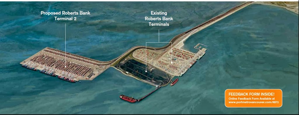
PMV graphic, click to zoom in.

They have just applied for an environmental assessment for the so-called Roberts Bank T2 Project, but are doing their own outreach to ask the community a few questions about the current project.

By “community”, I mean people South of the Fraser, because the pubic open houses are all being held south of the middle arm, but there is lots of opportunity for on-line comments, and with a comprehensive EA very likely, there should be more opportunity to talk over the next year or so.

My initial impressions are surprisingly (for some) not all that negative. However, before I present them, I need to do one of my every-so-often caveat things:

Although the footprint of this project is well outside of the City than employs me, my employer has been identified as a potential stakeholder in the project. I am in the department of the City that would theoretically be providing technical assistance to the City’s correspondence on the matter. That said, I have no pony in this race, nor have I any decision-making power in how EA or the Port plans advance, or how my employer approaches the EA. I am not privy to any behind-the scenes information, all I know about the project comes from the publicly-available records. Everything I say here is my opinion, not that of my employer or anyone else who may work for my employer, or any rational person, for that matter. 

With that out of the way, I’ll give a quick description of the project. PMV wants to expand the container facility at DeltaPort. This is part of on-going expansion plans out there on Roberts Bank. To put the expansion in perspective, cast you mind way back to 2009, when Hannah Montana was still a thing, and the Roberts Bank Container facility had an annual capacity of 1.2 Million TEU per year (“TEU” is twenty-foot equivalent units, essentially a 20-foot long standard container. The ones you typically see on the back of trucks on Royal Ave are 40-foots, equivalent to 2 TEUs, although the 2.6 TEU 53-footers at are increasingly common).

In 2010 a third berth was opened, which boosted capacity 50%, to 1.8 Million TEU. Since then, an ongoing project to improve the rail and road connections and off-ship container handling is aiming to boost capacity by 2015 to 2.4 Million TEU. If approved and completed, the current project will boost capacity yet again, to 4.8 Million TEU. As full build-out of this project will not arrive until about 2024, the net result would be a quadrupling of container capacity over 14 years.

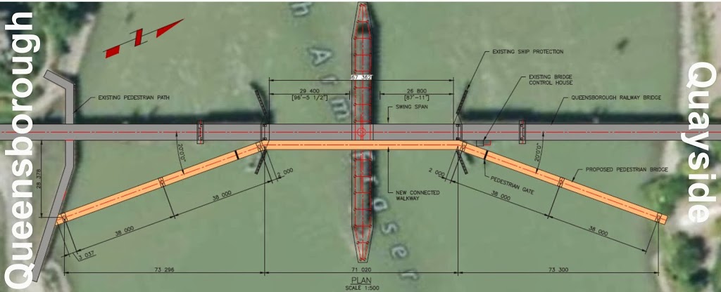
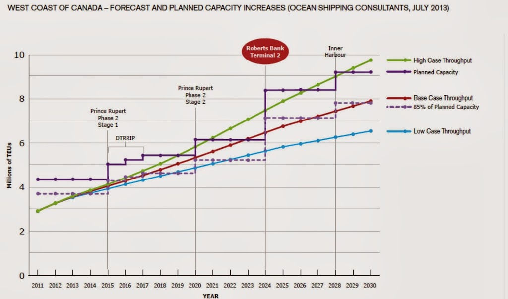
PMV’s own graphics Click to make bigger

Clearly, the Port is bullish on containers.

There is much to be discussed here, as the projected growth will impact every bit of our City and region. I want to concentrate on two specific issues at this early stage, both close to my heart. Transportation and the Agricultural Land Reserve.

Transportation
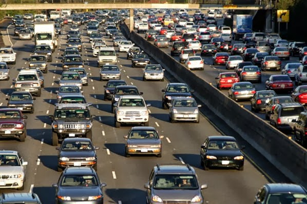
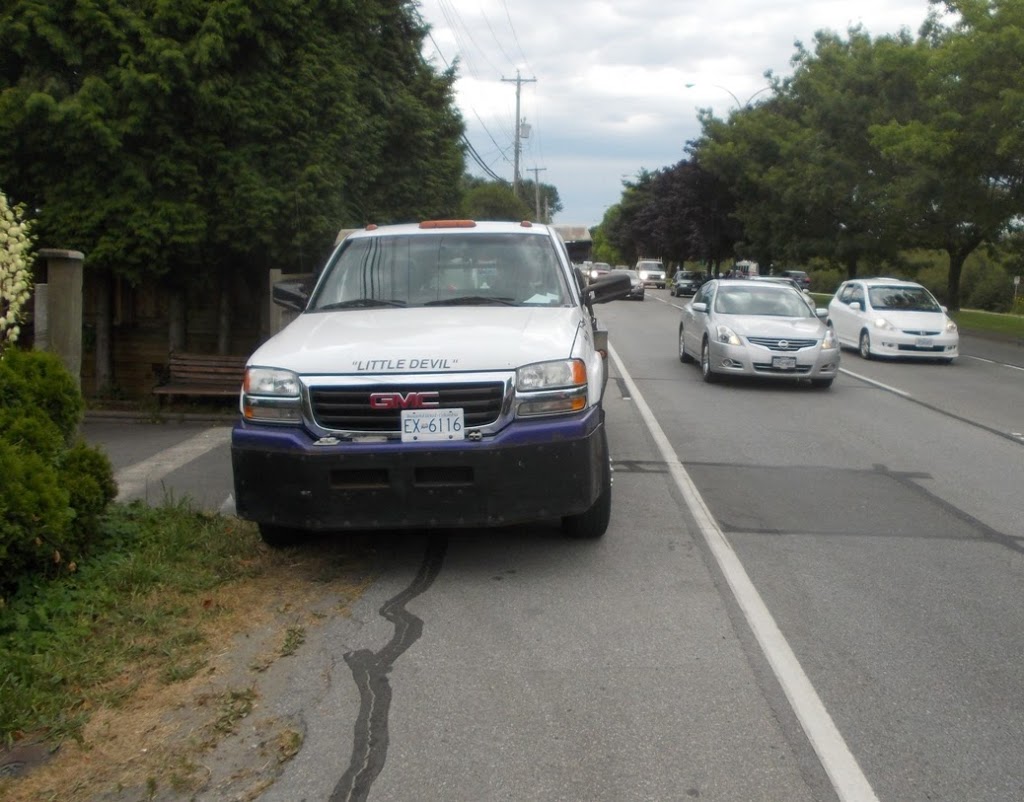
If you think there are too many container trucks on Royal Avenue now, what will it be like when container throughput is increased three-fold? Where are all these containers going to go?

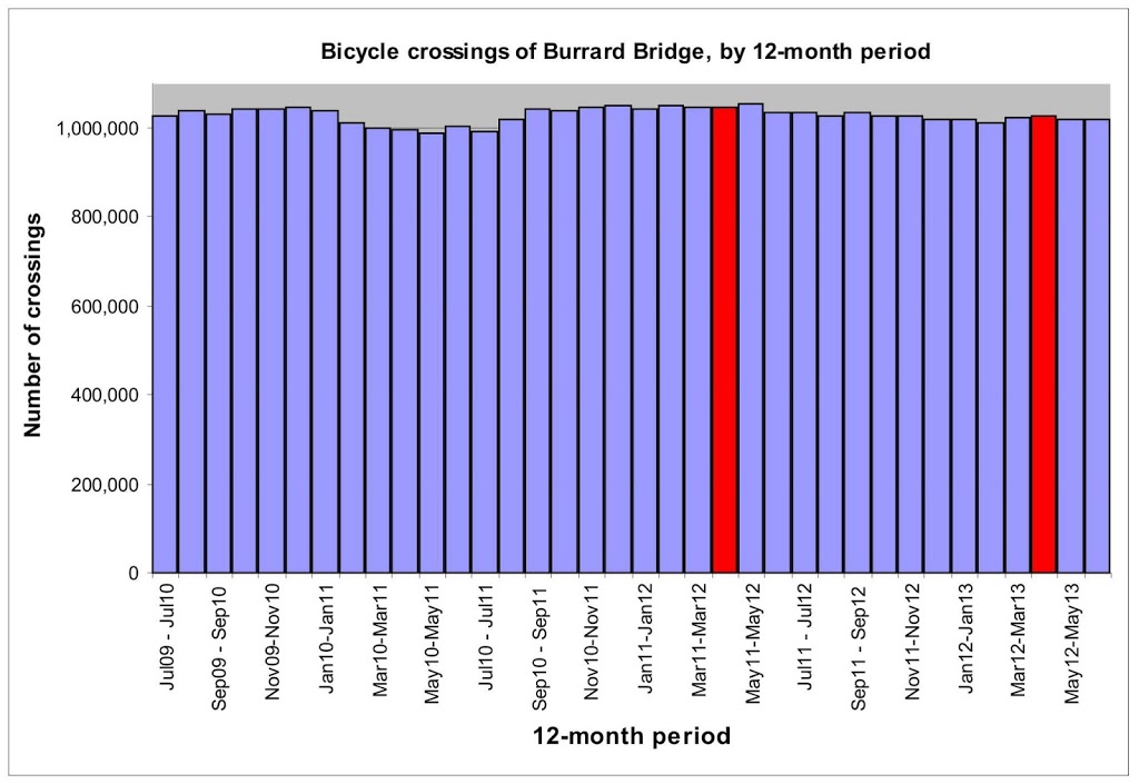
I dug through this recent report commissioned by the Port, and used as the justification for expanded container capacity at Roberts Bank, and the existing terminals in Burrard Inlet. There are a few lessons in here.

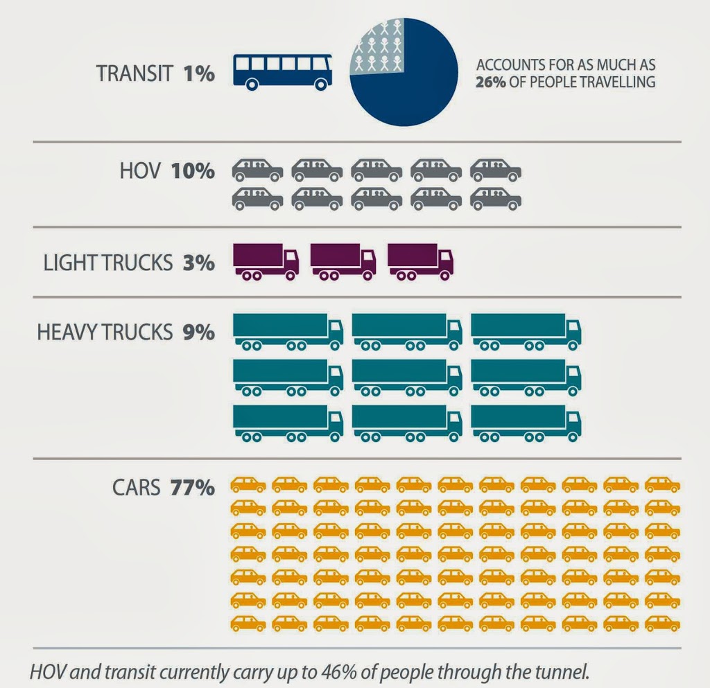
First off, Surrey Fraser Docks will not be a significant mover of containers at the Port for the foreseeable future, regardless of the fate of the tunnel or dredging of the river. Simply put, the average every-day container ships being built today are too large to navigate within the Fraser River. At 400m long and 60m wide, their 15m draught is the least of their worries. Port facilities along the Fraser River may have many uses, but moving containers on and off of boats will not be one of them, unless the Port decides to finally start investing in the type of short-sea shipping that was recommended to them a decade ago by this other report.

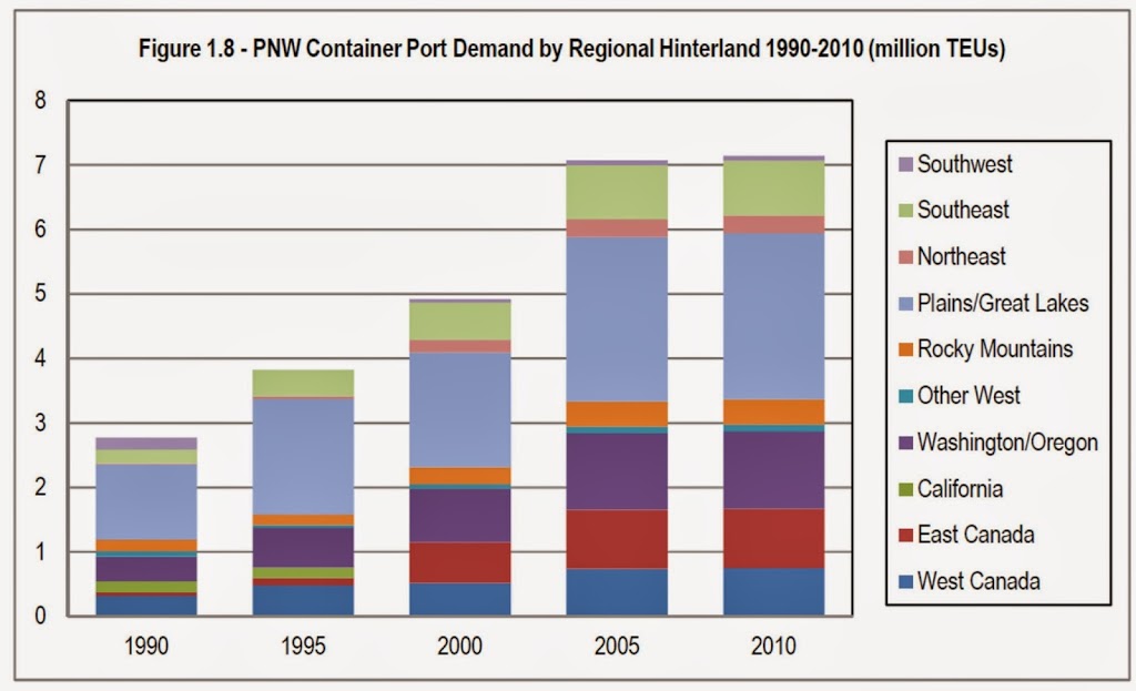
Second, note from the graph above (page 36 of the aforementioned report) that the vast majority of the import containers, more than 90% from 1990 to 2010, are bound for destinations outside of Western Canada. The forecasts deeper in the report suggest this trend will continue, as most growth calculations are based on competitive advantages accessing the Mid-West and eastern parts of North America though rail. This should reinforce the question – why are we moving these things around by truck? What are the economics of moving these containers from the boat to the truck to the multi-modal yard where they eventually end up on trains?

Part of the answer might be train capacity. It has been suggested by people much smarter than me that the single most pressing goods movement choke point in the Province is the New Westminster Rail Bridge, underlying a challenged rail infrastructure throughout the region.

However, this report suggests quite the opposite- saying that there is lots of rail capacity, and that the economic advantages of direct-to-rail are clear:

… the costs associated with trucking containers from terminals to rail yards were obviously highly uncompetitive. Hence, there was a switch in favour of on-dock rail facilities, and all new container terminals on the west coast either incorporate such a facility or provide on-dock access to an adjacent rail yard.” –pg 146.

So the economics make sense, the global trend is established, and the Port is making plans to take advantage of this reality. Which makes me wonder why we are still investing heavily in the building of truck-freeways to move trucks from the Docks to the Intermodal Yards? Why are we being told we have to accept the community impacts and cost to the public purse of all these container trucks when the economics don’t make sense?

There was one shocking statement a few pages later under Conclusions:

The only possible difficulty if proposed oil exports from Alberta were to compete for rail space with coal and container trains. Clearly, the correct mode for these exports will be by pipeline. This is the only potential capacity constraint for increased container volumes via Vancouver.” -pg 150

I don’t think any of us were under any illusions about the Port being an interested partner in the building of pipelines to move bitumen from Alberta to the west coast, but this dynamic is one that shows how complex, yet strangely tenuous, our transportation network truly is. How Coal snuck into the discussion here is another point of speculation. Are plans for expanded coal movement really suited to the Port’s expansion plans for containers?

Agriculture / Land Use
The current Port Boss has been questioning the preservation of Agricultural lands. He has gone so far as to say we don’t need farmland in BC, as we can import all of our food through his port. So it is really hard to give him the benefit for the doubt about this topic…but hear me out a bit.

It is possible that the building of new land out where DeltaPort is currently located will reduce the pressure to re-purpose existing new land in the lower Fraser Valley from farm to Port servicing. If we accept that the Port’s expansion models are realistic, and we accept that expanded movement of container goods is a great thing for our economy, and Roberts Bank Terminal 2 is designed to primarily move goods on and off of boats and on and off of trains (three big “ifs”, admittedly), then of all the places for this activity to take place, perhaps Roberts Bank is the best option. Maybe this is a project that Environmentalists can somehow “get to yes” on (to borrow the parlance of the day).

The habitat loss out on Roberts bank will be small, and adjacent to already highly disturbed habitat. With some creative design, there is no reason T2 would create any harm outside of its 100 hectare footprint. It could be argued that compensatory habitat required under the Fisheries Act will be of higher quality than that lost through this project, but that is yet to be seen, and something that will come out during the EA.

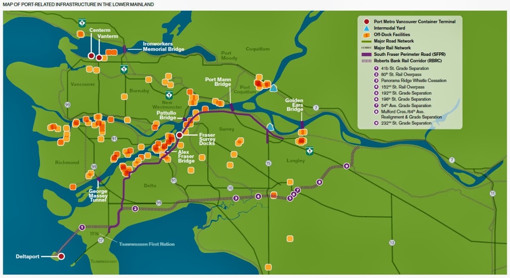
PMV Graphics, Click to zoom in.

Public meetings:
There will be 5 public meetings, starting tomorrow, led by the Port, and discussing three aspects of the project: Habitat Mitigation Plans, Methods for improving Port-related truck traffic; and ideas for community legacy benefits. As I said, they are all South of the Fraser, but you might want to make the trip and check them out:

October 16 @5:00pm-8:00pm      UBC Boathouse, Richmond
October 17 @5:00pm-8:00pm      Surrey Arts Centre, Surrey
October 22 @5:00pm-8:00pm      Coast Hotel , Langley
October 24 @5:00pm-8:00pm      Delta Town & Country Inn, Delta
October 26 @10:00am-1:00pm    Coast Tsawwassen Inn, Delta

On Bridges and Consultations

There’s been a lot of talk about a new bridge in New West. Some love the idea, some hate it. Paradoxically, those who will use it the most (those right next to it) hate it the most: at least those on the north side of the crossing. Those on the south side seem to insist a better connection is needed.

The initial designs were met with much gnashing of teeth and rending of garments. The consultation was a sham! The options were not viable!! The neighbourhood will not stand for it!!! Pleads of urgency and need were tempered by vaguely Nimby-esque calls for caution and/or outlandish alternatives. Loggerheads were met. Funding sources were debated, petitions were signed, Council was implored.

So the responsible agency hit Ctrl-Alt-Del; sent the engineers back to the drawing board to re-evaluate and return with better options. Third parties were brought in to consult. Previously-discarded options were reconsidered. Numbers were crunched, common ground was sought, new sketches were proffered. More than a year later, the conversation is re-booting, and it is time for you to provide your input. Yet again.

I am talking, of course, about the proposed Quayside to Queensborough pedestrian crossing (what else?).

The people of New Westminster are being asked to comment right now on the two options that have been pencil-sketched for us. We have on-line info, there has been a travelling “whattya think of the bridge now” road show at most recent community events, Ted Eddy has expressed his opinion(s), and all that is left is for you to spend 5 minutes filling out the quickie questionnaire. You have until October 16, 2013.

Allow me to opine.

The current proposals address one of the biggest challenges for the project as originally conceived: the Navigable Waters Act requirement that there be 22 metres of air above the River to allow medium-sized ships to pass into and out of the North Arm of the Fraser River. Less than 22m, then the bridge has to be openable, like the current swinging train bridge in the location.

The engineers have come back with two options to avoid the 22-m high bridge that made for an opposing edifice and a challenging ramp for the less-able-bodied. “Option A” is a bridge that coalesces with the swing span of the existing train bridge, and opens and closes with the rail bridge. “Option B” is a bascule design, which is a drawbridge common to medieval castles and the Chicago River. This would be build adjacent to, and separate from, the train bridge. Each have advantages and disadvantages.

Note there is a language issue here. When talking about a draw or swing bridge, relativity rules the use of the terms “open” and “closed”. Since I (and presumably you) see this as primarily a piece of pedestrian infrastructure, “open” would mean you can walk across it, and “closed” means you cannot. This differs from the mechanical and nautical view of an “open” drawbridge being one where boats can pass. So just to make things clear: when I say open, I mean closed to boats; and when I say closed, I mean open to boats. Clear?

The primary advantage of Option A is cost. The study suggests the entire bridge can be built for $5 Million, which is less than the remaining DAC funds that have been allocated for the project. The bridge will also be slightly lower with shallower ramps and less visual impact for residents.

OPTION A: You can click the image to zoom in.

There are however, significant negatives related to this option, mostly related to being literally mated to the existing rail bridge. The owner of the bridge (Southern Railway / SRY Rail Link) has indicated that pedestrians will not be permitted to use the bridge while a train is present (currently, about 8 trains cross the bridge every day) which could cause significant delays for people hoping to cross the bridge.

OPTION A: You can click the image to zoom in.

The existing train bridge is 100 years old, and there are some questions about the longevity and engineering reliability of that crossing. Attaching a multi-million dollar piece of City infrastructure to a privately-owned piece of infrastructure approaching the end of its service life may not be the most prudent choice, and may represent “penny wise, pound foolish” planning. What happens to that investment if the rail owner decides to replace their aging bridge in 10 years? What if a moderate seismic event or barge collision closes the rail crossing for an indefinite period? What are the odds SRY’s business plans will change at some time in the 75-year lifespan of a pedestrian crossing? Arguably, these issues may be managed through a deftly-negotiated agreement between the SRY and the City, but some risks will still be there for future administrations to deal with.

Option B will be higher than the existing rail bridge. With 9.6 metres clearance above high water mark, it will not be so big that the on-ramps will be daunting, but high enough that many of the boats that pass the rail bridge will not require the pedestrian bridge to be opened (um… closed). Current estimates have the Option B bridge being open for boats less than half as often as Option A. It will also not be tied physically to SRY’s bridge, so changes in rail operations or replacement of the century-old wooden structure will not adversely impact the accessibility of the pedestrian crossing. This is all good.

OPTION B: click to make bigger.

The downside, of course, is the increased cost. At an estimated $9.6 Million, there will need to be a second funding source aside from the remaining DAC funds. The City will have to shake out the couch cushions or borrow to fill the funding gap and get the job done.

OPTION B: click to make bigger.

When discussing the Q2Q pedestrian crossing, people talk about it in different terms. Some think of it as a nice amenity, a connection between neighbourhoods, an extension of the park system or a tourist draw. I think of it as all of these things, but primarily as a vital piece of transportation infrastructure. With this in mind I quote myself:

Ultimately, I only hope the crossing will be reliable – one you can count on being there when you need it, and not unexpectedly opened [sic] for a hour at random times – because I see this bridge primarily as a transportation link… then it will be the link we have been missing up to now.

So I vote for Option B.

As for the money, let’s go back in time a bit. The DAC funding was part of a negotiated package the City worked out with the Province over permitting for the Casino. The original allocation of $60 Million looked like this:

$5 M for park improvements across Queensborough;
$35 M for a Multi-use Civic facility in downtown;
$6 M for a new and improved Queensborough Community Centre;
$4 M to improve the docks at the Quay;
$10 M for a Quay-to-Queensborough pedestrian crossing.

The two Queensborough community projects have been delivered: Parks in 2011, the Community Centre in 2013. Last year, the City decided, and received permission to, “reallocate” $8 Million from the last two projects to the MUCF, which became the Anvil Centre. They more recently announced the dock program is not likely to happen any time soon. That leaves $6 Million for the Q2Q Bridge.

Back when the original Q2Q Bridge plan estimates came in around $20 Million, the difference between $10 Million and $6 Million in available DAC funding seemed a little academic- they were still going to have to pop for a significant amount of money to fill the gap. So transferring some of that money with uncertainty attached to the much more certain (as there was a hole in the ground having cement poured into it) seemed like a good idea at the time.

Now that the revised, reasonable, and more acceptable to the community “Option B” estimate is $9.8 Million, the City has a bit of a problem. What to do when the better option is within your original committed budget, but you have now re-allocated such that there is only enough left to pay for the lesser option?

The Bridge to Nowhere.

I have already opined about the potential to replace the Massey Tunnel back when the rushed “consultations” were launched in the Spring. People with better minds than mine have already challenged the base assumptions built into the apparent need for a replacement using the Ministry of Transportation’s own numbers.

This week’s announcement that this low-priority election bauble was pushing on, full steam ahead, despite the objection of pretty much every Mayor in the region* except for the one who doesn’t want to pay for it, is still a little confounding. Our all-but silent rookie Minister of Transportation continues to dither about Transit funding models and a still-born referendum, everyone from Teachers to Nurses to Social Workers are being told there is no money in the kitty for any of their essential programs, but for some reason this multi-billion dollar boondoggle is a Provincial Priority. Depressing, but not shocking.

Since the announcement was amazingly bereft of details: size, scale, scope, costs, tolls are all things we can only speculate on. The only substantive thing we have to base our speculations upon is the fly-through animation of the proposed bridge, a fanciful piece of salesmanship no doubt created in a wet dream by the very engineering firms and Project Managers that are now engaged by the Ministry of Transportation to sell this product to a reluctant taxpayer consult on the project design and implementation on behalf of the Government, so they can eventually get paid by the same Government to build it. You know who you are.

First off, note the lane count. 10. Well, 12 if you include the “safety lanes” that appear to be full-lane width on this rendering. Plus a bike/pedestrian path. As drawn, this bridge will be wider than the Port Mann, the alleged widest bridge in the world.

Yes, two of those lanes will be “HOV” lanes. Note the HOV lane is dominated by cars and commercial vehicles, which makes them very different than the HOV lanes we know and love.

Note no substantial changes to the design of the Steveston Highway intersection as far as lanes in and lanes out, (although it looks like the overpass will be blown out to 4 lanes, which will not do much for Stevenson and No 5 Road).  Note especially how the free-flowing traffic from the new bridge disappears as it exits to the 2-lane Steveston Highway, as if by magic. The magic of road builder renderings. That traffic is distinctly “somebody else’s problem”. Or the next problem they will get paid to solve.

Nor do will see substantive changes to the Highway 99 / Highway 17A intersection. Except, of course, the current 6-lane Highways that extend through farmland away from the Bridge north and south are shown to be 10 lanes wide as far as the eye can see. Pity the Oak Street Bridge, I-5 Seattle, here we come.

Note the pedestrians on the bridge. There are a dozen pedestrians and three cyclists shown. Cyclists I’ll give you, but the bridge is 3 km long, with the north end ramp more than a kilometre from the nearest doorway of any kind, and the south end something like 5 km from any likely destination, be it residential, commercial or recreational. Where the hell are these walkers going?

Perhaps they got tired of waiting for the transit that never showed up, as the established bus stops on the Richmond side of the bridge have been removed, and the HOV lane moved to the middle of the freeway, so Transit connections have clearly not been thought out here. Probably TransLink’s problem to solve.

At least I give the rendering props for truthfully representing the types of vehicles that use the Massey tunnel route. In the animation, 83% of the vehicles shown are private cars, 14% are commercial trucks, and 3% are buses. Admittedly, they are “tour” bus types but let’s assume the animator meant for these to be ultra-luxury Transit buses that will come with expanded Transit funding to go with the new road (yes, that was sarcasm).

These stats are close to the actual current count of traffic going through the tunnel: 87% cars (including HOV, which means at least one passenger), 12% trucks, 1% transit.

Source: Massey Tunnel Replacement Consultations.

Actually, the 2% increase in trucks is almost exactly the increased number that will result from the most ambitious Port expansion plans at Terminal 2. Keep that 2% number in mind when you are told “Goods Movement” is a primary reason for spending a couple of billion of your dollars to replace the tunnel.

In contrast, the displayed tripling in transit service is clearly fanciful, as TransLink has no money to maintain the routes they currently run. This is important, because if transit use (which at 1% of vehicles, already represents 26% of the people travelling through the tube) tripled, then the numbers of cars going through the tunnel would be reduced by half. Which would end our congestion problem for a much lower cost than a $X Billion bridge.

Alas, I heard Moe Sihota speaking for the NDP on the Rick Cluff Radio Confrontation Hour (follow link to about 1:50:00) this morning, also agreeing that the tunnel needed to be replaced with a big shiny bridge, using the same incorrect data and false assumptions as Premier McSparkles(Tm). Of course, he disagreed with Colin Hansen on some arcane aspect of the funding or the opportunism of the announcement, but he was all for pissing away you tax dollars entrenching another generation of motordom.

This leaves the 100,000 daily transit users on the under-serviced Broadway Corridor and the tens of thousands in Surrey loading on stuffed and increasingly unreliable SkyTrains every morning wondering who represents them.

*note, just before writing this, I heard an unintentionally hilarious interview with Mayor Diane Watts of Surrey, where (the always-excellent) Stephen Quinn has her so confused by her own talking points, that she appears to be all for the Bridge, although it is a low priority compared to pretty much any other transportation project; for tolling the bridge, though against tolls, except for them if they are low, except not unless everyone pays; and against a Transit Referendum, except for it when important for deciding transportation alternatives, except when it isn’t. It is well worth the listen.
  

Parking variances for new developments, and other Green things

Remember that whole Downtown Parking Strategy and the concomitant “Tear Down the Parkade” movement? What ever happened with that?

There are two recent news stories that are directly relevant to this study, both about newly-proposed developments in the Downtown.

The first development plan is for a location in deep need of redevelopment: the mid-block area on the north side of Carnarvon across from Plaza88. The so-called Carnarvon Gardens (ugh…) development is creating a bit of a disagreement on Council because of various challenges in providing parking space and the impact on the neighbourhood form.

At least part of the reason for debate here is the location across the street from Plaza88, whose own parking situation is an ongoing cause of chagrin. As I have said many times before, Plaza88 is a great idea as far as Urban Planning, but suffers from some poor execution as far as Urban Design. One of those issues is the wall of parking lots that provide the facade of the building. The multiple stories of above-ground parking exacerbate the canyon effect on Carnarvon, at least partly because it is not “human space”, but machine space. If that facade was windows and balconies with evidence of human life, the effect would be much more gentle. If it was set back from the street by a few metres, it would be even better.

The proposal for Carnarvon Gardens, right across the street, is to have a similar 5 stories of above-ground parking, but to hide most of them behind a wall of office/commercial space, much like the bottom two floors at Plaza88. The top floor would not be so obscured, nor would the Victoria Street facade or the little side-lane that connects Victoria and provides access to adjacent buildings (9th Street?).

The development looks great- (you can see it in these Meeting minutes, starting down on page 88) – 23K sq.ft of office space, 10K sq.ft. of retail, and 198 residential units. But even back in July, Council asked questions about the plan for parking. Originally, 308 parking spaces on 7 floors (2 underground and 5 above ground, at least on the Carnarvon side) was proposed, although the current Bylaw requires 353 spots. After sending the July plan back for more consideration, the proponent came back with a similar proposal (two underground parking floors, five above ground) but have now reduced the number of parking spots, based on two studies.

The Downtown Parking Plan study suggested 278 parking spots were required here, where the Proponent’s own study indicated 260 were required to service the building’s needs. The Proponent, however, is willing to build 294 spots- as they figure that is the magic number that balances the cost of building parking with the “marketing goals” for the condos. They also balked at the idea of moving the exposed 5th floor parking down underground where it will be out of site, presumably because of increased costs.

During discussion at Committee, Councillor McEvoy raised an excellent point, in that there will be a time (perhaps now?) that we stop thinking about the street presence on only one side of a building. This development “backs” on Victoria Street, but other businesses and potential future developments front on Victoria. So why is a parking lot facade that is not acceptable on Carnarvon acceptable on Victoria? If we want the best revenue-generating and job-creating parts of our renewed Downtown to expand, then we cannot afford to create more “dead space” roads. More imagination is needed here.

The second development plan is much more preliminary, according to this story, but has many parallels other then being three blocks to the east. This building will have 7,500 sq.ft. of commercial and 282 residential units, planned for rental as opposed to market condos. Here, the Bylaw parking requirement is 410 spots, the Downtown Parking Study suggests 218 are needed, but the Proponent is proposing 169.

So two concurrent (or close enough) developments one block uphill from Columbia Street, and both want to save money by not building parking. A bit of quick math gives us:

Bylaw Requirement: 763 total spaces.
Parking Study demand: 496 total spaces.
Proposed to be built: 463 total spaces.

So depending on how you count it, there are between 33 and 300 parking spots being left on the table. These are spots the Developer is required to install according to existing City policies, but is asking for an exemption because they won’t make any money from them.

Now compare those numbers to the “peak use rate” of the Front Street Parkade according to this report to council. 38% of 800 parking spots is 304. Now you (hopefully) see where I am going.

This is, ultimately, the solution to the Front Street Parkade problem – distributed parking in new developments. I’m not saying both of these buildings need to build parking to 100% of their (now dated) Bylaw requirements, but there needs to be a discussion about how new developments provide public parking at rates similar to the Parkade. 30 to 50 lots in each new building, the construction paid for by the Developer and the rental income going back to the Developer (unless, of course, they choose to sell the parking lot rental business off) to offset the cost.

Instead of pulling into a decrepit waterfront white elephant, one can find public parking in any of a half dozen buildings within a block or two of your destination. And we get a major part of our waterfront back.

This is not as easy as it might seem, though. We need to convince the Developers that it is worth their time and money. We also need to worry about the urban form issues that Councillor McEvoy raised, and that threaten to make Carnarvon and other streets into car park canyons. However the first step is to stop handing out variances for every new building so Developers can save the hundreds of thousands of dollars it takes to provide market parking. Instead, we need to create the market incentives to make it worth the Developer’s time to install public parking as part of every new large development.

As for the Parkade, it is not giving up without a fight. It has apparently been exposed to Gamma Rays, and vents its occasional rage through Twitter:

So there’s that.

The ALR development cycle

This is a story with more layers than an onion, and is so absurd that it should be in the Onion.

The City of Pitt Meadows, against the protestations of its citizens, wants to fix a traffic problem by building a big-box retail strip mall on 80 acres of ALR-protected farmland.

Read that again. That is the case Pitt Meadows successfully made to the Agricultural Land Commission.

Boggles. The. Mind.

The longer version of the story is thus:

You see, Old Dewdney Trunk Road  (ODT Road) is a rural two-lane that runs through farmland in Pitt Meadows north of Lougheed Highway. Mostly protected from development by the Agricultural Land Reserve, the ODT Road area is mostly larger farms, and protected from the strip mall and low-density housing explosion that has grown around Lougheed Highway – stretching almost undisturbed from Coquitlam Centre to Haney. Problem is, being the “back route” around the inevitable Lougheed Highway congestion, ODT Road is suffering from more traffic than the old rural two-lane is designed for.

This problem was apparent in the 1990s, but Pitt Meadows was not all that concerned, because the Pitt River Bridge was being expanded, and more lanes of Lougheed were being built. As a bonus, the Golden Ears Bridge was coming to take some of the traffic load off of Pitt Meadows, and a brand new semi-express way was being blasted through farmlands to the east, providing easy access to the Golden Ears Bridge for all those single-family homes that have been built out around Abernethy Way, which was all, notably, farmland less than 30 years ago. Pitt Meadows was not worried, because with all these new roads being built, traffic congestion on Lougheed would soon be a thing of the past- and ODT Road could go back to serving local farmers.

Except, of course, the roads did not take the traffic away, the roads brought more traffic. With easy highway access came more single-family homes that can not be served adequately by transit when TransLink is cutting services, and came more strip-mall retail shops to serve the needs of the growing car-dependent community. Few real family-supporting jobs are created in these strip malls, so people cannot actually work near their single-family home, and commuter traffic inevitably got worse, not better, with the new roads. That is what we call Induced Demand.

So the City of Pitt Meadows, shocked (shocked!) that these new roads have not fixed their traffic problem, has found a solution: one more road. This is where we get the proposed “North Lougheed Connector”. Problem is, after the Ministry of Transportation blew their budget on the Pitt River Bridge and Lougheed Highway improvements to fix the traffic problem in Pitt Meadows, and TransLink is bleeding through the ears in part because of a shitty Golden Ears Bridge toll deal that was supposed to fix the traffic problem in Pitt Meadows, neither have the money to build this one last road that will finally fix the traffic problem in Pitt Meadows. Even with all the single-family home building and strip malls, Pitt Meadows doesn’t have the money to fix the traffic problem in Pitt Meadows.

Along come Smart Centres, strip-mall builders of some fame. They have the money to fix the traffic problem in Pitt Meadows. They are more than happy to build a short stretch of highway through land they don’t own (because like the Golden Ears Way, and a fair chunk of the South Fraser Perimeter Road, the North Lougheed Connector will be built on protected ALR land, no need to exclude from the ALR for roadbuilding, alas). Only catch is that the new road has to include off-ramps to their parking lots for their new strip mall. The parking lots and strip mall they want to build happen to be on land they bought at ALR rates, and that they will lease out at Commercial rates now that they can get more than 80 acres of that that cheap land out of the ALR just for building a road through more ALR. Good business if you can get it.

The 80 Acres in question is between the golf course and Harris Road. Click to enlarge.

It is the circle of progress: build low-density housing on ALR land, build freeways and bridges to access them (if someone suggests alternatives like density, transit, or bike lanes, cry “tax grab!”), when traffic gets too busy, build more roads, take more land out of the ALR and build houses on that land to fund it, lather, rinse, repeat.

So why do I, a local blogger in New Westminster care about Pitt Meadows strip malls? Because this is, boiled down to its essence, New Westminster’s traffic problem. When TransLink or the Ministry of Asphalt talk about the North Fraser Perimeter Road– turning local New Westminster streets into highways for through-traffic, it is this strip mall in Pitt Meadows that will be at the east end of that highway. Traffic problems being generated by bad planning in the Pitt Meadows (Surrey, Langley, etc.) today will be used as an excuse to destroy the livability of New Westminster.

The ALR does more than protect agricultural land, it protects the livability of our region. Don’t let Bill Bennett destroy it.

On TransLink and the referendum

I really wanted to write an in-depth piece on the TransLink Funding Referendum; a withering piece using phrases like “abhorrent abdication of accountability” and “irresponsible idiocy that threatens the livability of the region”, but I realized there has already been a ton of good stuff written on this issue.

So before wading through MY diatribe below, why not see what noted Bridge-and-Freeway advocates like Mayor Diane Watts and Mayor Richard Stewart have to say on the subject. Or you can follow the writings of the leading thinkers on regional development, like Gordon Price, or Stephen Rees. Or how about the dirty hippies at Business in Vancouver? It seems no-one outside of the Premier’s office (and it’s PR wing at the Vancouver Sun) think this is a good idea. Even the new Minister of Transportation seems to skirt around the issue.

The Referendum is a bad idea, and perhaps the best way to explain how bad and idea is to take a (supposedly) thought-out and argued case FOR the referendum, and disassemble it. Please forgive me if I stray towards a Strawman fallacy here, but I am not making up a preposterously weak pro-referendum case here, I am just relating one that appeared in one of the PostMedia Papers of Note. If you hear a better argument for the referendum than the one I critique below, please send it to me, so I can tear that one apart as well.

I present to you, Province “Metro View” columnist Jon Ferry:

I’m no huge fan of referendums to resolve major public-policy issues, any more than I’m of penalty shootouts to decide hockey or soccer games.

Why are you not a fan of referenda? Perhaps you can expand this, because the 490 words following your initial expression of dislike seems to argue that referenda are a good idea, even for complex issues. If you hate them, why are you advocating for one? This sentence makes the rest of the discussion sound like one of those rants your drunk uncle goes off on that starts with “I don’t want to be racist, but…”

But they have their place, especially when an issue gets so tied up in political knots that a direct appeal to the people in a simple, take-it-or-leave-it vote is the only way to disentangle it.

But this cannot possibly be a simple take-it-or-leave it vote, can it? If that is what you are proposing, a question that says: “Do we want to raise your taxes through ‘X’ to pay for a subway to UBC and buses to White Rock and fancy offices for TransLink bureaucrats who couldn’t plan their way out of a wet paper bag? Or not? ” then we all know it doesn’t matter what the ‘X’ is: it will fail. We all know this is how any request for more tax money from any source will be framed by the Vancouver Province and Sun other car-dependant media. I hardly exaggerate, as you can see that narrative is already being drawn.

Then we will all be here in the same place 16 months from now, wondering why Skytrain keeps breaking down and why busses are passing people by on the curb, with no plan to deal with it and no new revenue source. If anyone can imagine a simple yes-no referendum question to which the majority of voters will say “Yes” and which will also lead to TransLink being funded adequately to meet the Transport 2040 goals, then I have not yet heard it expressed. The referendum will not untangle any political knots, it will only tighten the string for another two years and drag TransLink failures into the Municipal election cycle, pitching “Pro-Tax Mayors” against “Anti-Tax Mayors”.

That’s why I think the Christy Clark government must not bow to the wishes of the Metro Vancouver mayors and must refuse to renege on its election pledge to hold a referendum on possible “sources of new funding” for TransLink.

Right. Why should the Premier show any leadership at all, or even work together with the Mayors in an honest discussion of the issue without the side-show of a doomed referendum? The TransLink Board is her baby – it came with the job – so unless she is willing to turn TransLink back over to the Mayors to run, she should start thinking about how she is going to pay for it, and take the plunge. It is the willingness of Victoria to make random and ill-advised decisions regarding TransLink (FalconGates, the terrible Golden Ears Bridge deal, endlessly delaying Evergreen) that has put TransLink in its current financial bind. Now the Premier wants to continue to run TransLink from Victoria, but get the Mayors to pay for it so she doesn’t have to raise any taxes. The Mayors are right to tell her to get bent.

I believe that the mayors are being downright patronizing when they say the topic is too complicated for voters in their area to decide upon.

Look- referenda have their place, but this is not it.

I think referenda should be reserved for significant changes to government structure (e.g. changing the Constitution) or questions where our “social norms” are being evaluated (e.g. the legalization of marijuana). Where they should never be used is when the question is one of the rights of a minority (e.g. same-sex marriage equality or  the stunningly inept BC Aboriginal Treaty Referendum of 2002).

I would include tax policy as a third subject that should never go to referendum. (see discussion of HST referendum below). Ultimately, revenue generation and spending is what we hire a Government to do, it is the core of the budget every year, and in a place like BC where the government rarely sits in a legislature, it is almost the only thing a government does. There is a referendum on their tax policy, and it is held every 4 years. It is bad governance to parse out one small part of tax policy and put it up for referendum, because you cannot forecast spending or growth, you cannot even frame a balanced budget, unless the results of the referendum are pre-determined. Which, in this case, it will be, So why go through the exercise?

They’re also being alarmist in claiming a defeat by taxpayers of new “sustainable funding” — meaning new taxes — would doom metro to a stagnant transit system.

Alarmist? How is pointing out the obvious negative consequences of delaying, yet again for another year or two, investment in public Transportation being “alarmist”?  If you do not think the current funding crisis is hurting the current system, you have not tried to catch a 99 B-line or been on a westbound SkyTrain at 8:00am or had to make last-minute changes to your plans because “switching problems” scuttled the morning Skytrain Commute for the third time in a week.

A “stagnant Transit system” is, at this point, not “alarmist”, but an optimistic dream. In the last year, TransLink has not only been unable to move ahead on expansion plans (other than the Evergreen Line, which is finally seeing construction after more than 20 years in delays, mostly due to money committed years ago), they have actually cut bus routes to growing communities. Queensborough, Coquitlam, Maple Ridge- these areas are seeing bus service reduced, even as their population and density increases. The system is shrinking, squeezed of dollars at the same time that Billions are spent on new freeways and bridges. As service becomes less reliable, people will stop relying on it, and will instead avail themselves of all those new roads and bridges, increasing congestion, increasing GHG impacts, increasing roadbuilding costs and maintenance, making our communities noisier, less safe, more crowded, and more polluted. This will cut TransLink off from what has become its most stable form of income- fares. Indeed, with no more money inputs, the system will not stay stagnant- it will fail.

Now, I disagreed with scrapping the HST. But I think Victoria was right to put it to a referendum in 2011, if only to clear the air.

OK, let’s nip this comparison in the bud. Victoria was forced to put the HST to a referendum, they didn’t decide to – they had no choice! This was an example of a bad policy choice being made by the populace in a referendum, simply because the word “tax” was attached the wrong side of the story. This actually makes the case for the “patronizing” position of the Mayors.

What should have happened with the HST is the Government of Gordon Campbell should have been honest with the populace, introduced and explained the HST to the public, and sold them on the merits of the tax over the old system. They should have done this a year before the provincial election when they started negotiations with the Feds, not just introduce it with little warning a month after an election. The referendum campaign and overturning of the HST was a reaction to a dishonest and cowardly government, not a bad tax. Any policy discussion where Bill Vander Zalm is seen as the voice of reason is a clear sign governance has gone off the rails. The conversation during the referendum was distorted into an anti-Gordon Campbell plebiscite and the result was a bad decision made for the wrong reasons.

And I think a fairly worded referendum on raising, or not raising, new tax money for metro area transit would do the same.

Really. You honestly think if during a Municipal election, the government asks the Taxpayers of the region if they want to pay more taxes to build a subway for UBC students and bike racks for buses (because, mark my words, that is the level of discourse we will end up having around this referendum) that there is any chance of more than 35% of them voting yes? What planet are you sending your dispatch from? Please, Mr. Ferry, or anyone, show me a question that will result in a properly funded regional transportation system. I dare you.

The Mayors Council on Regional Transportation voted June 19 to formally oppose such a referendum, planned for the fall of next year, saying “making complex policy by referendums is contrary to principles of good governance.”

Of course, no-one ever accused Christy Clark of good governance. She can sure campaign, but so far her governance skills are as suspect as her driving. This is why, when she is stuck in a corner here and needs to display some governance skills, she is choosing instead to make a “campaign” of it. She will turn the entire conversation about the future of the region into one of those he-says/she-says confrontational radio call-in shows that were her specialty. The conversation will not invest deeply in fact, established principles of regional or transportation planning, systems science, or any of the complex ideas that make up a complex infrastructure strategy. It will be quips and “ya know’s” and pandering to the voter about what is “important to families” and gotcha moments. There is no risk of good governance arising from this.

What pompous nonsense. The public makes great decisions on complex issues at the ballot box, even if the politicians they elect aren’t always the brightest of the bunch.

(I’ll leave aside the fact you just said you disagree with the results of the last referendum) Following your reasoning, what decision should NOT be made by Referendum? I never got to vote on the $5 Billion spent on Gateway freeway projects (the SFPR, Port Mann2, Highway 1 expansion, etc). I never got to vote on a $500 Million roof for a football stadium. I never got to vote on the Billions spent on the Olympics. I am not being offered a vote on the replacement for the Pattullo Bridge, or the Massey Tunnel, or on the Kinder Morgan Pipeline expansion. I cannot even vote on the betting of our entire province’s economy on building a half-dozen LNG plants. If the single largest industrial investment ever in the Province, one that will radically restructure the BC economy while contributing multiples of our current GHG output to the atmosphere isn’t worthy of referendum, if no other transportation infrastructure investment in the history of the Province has ever needed a referendum, If BC Ferries rate increases, BC Hydro Rates, Carbon Tax increases, run-of-the-river hydro expansion, the sale of our Provincial assets, if none of these can be trusted to referenda, why this one little local transportation authority held to a different standard?

No, the big problem with the provision of public transportation in our region of 24 local authorities is that those supposed to be piloting it get so paralyzed by indecision they don’t seem to know whether they’re coming or going.

So fallacious an argument that it isn’t even wrong. TransLink knows exactly where it needs to go. Transport 2040, knows the funding it needs, knows what is available to it and what isn’t. The Mayors are also on side, as is the regional government. The direction forward is clear. Planning- knowing whether they are coming or going- is not TransLink’s problem. Political interference that drops in just long enough to muck up the the business plan, then steps back to avoid accountability is the Problem. The only people who paralysed with indecision on TransLink have been completely ineffectual Ministers of Transportation Blair Lekstrom and Mary Polak. Kevin Falcon, when he was in the role, made bad decisions that are still costing us, but at least he made decisions.

Part of the reason for this is the awkward/awful governance structure of TransLink. There’s also confusion about whether TransLink is a bus firm, rail company or simply another Vision-style bicycle-promotion scheme. Or is it an agency genuinely serving the travelling public?

I cannot believe one the major newspapers in Vancouver could have a “Metro View” writer express such a stunning ignorance of the largest single issue in the region today. No wonder Postmedia’s ship is sinking. TransLink is a regional transportation authority, responsible for a “bus firm”, three distinct “rail companies”, a transit ferry, three bridges and the entire Major road Network (>1,000km of roads used by cars every day!), and, yes, indeed, last year they spent 0.2% of their budget on bicycle infrastructure to further the Great Socialist Cycling Agenda. In every aspect of the above, they are serving the travelling public (even those who dare travel on bicycles!). They move hundreds of thousands of people every day – it is virtually impossible to move in the City without interacting with one of thier assets, and are one of the most cost-efficient transportation authorities in North America. If Mr. Ferry is confused about TransLink’s role, he should start reading, or get a new job far, far away from the “Metro View” file. Maybe you can parlay your talents into full time Climate-Change denial, as you only seem to dabble in it these days, and that stuff can really pay off.

B.C.’s new transportation minister, Todd Stone, confirms there’ll be a referendum on possible new TransLink funding sources, but the wording of the question to be asked voters still has to be decided. He says discussing this with the metro mayors is one of his top priorities. How TransLink is governed will also be addressed.

Wait- maybe there is some promise here. Why not have a referendum just on the governance? Because we all agree – the taxpayer, the Mayors, and now even the Minister of Transportation, that this is the problem with TransLink. Simple question: Who should run TransLink, a Council of Mayors that the voters get to vote for, or an unaccountable board of Political appointees chosen by the Premier?

“We have committed to having the governance worked out and agreed upon in time for the spring sitting of the legislature in 2014,” Stone told me.

Worked out and Agreed upon might be two different things. It is clear the Mayors are not going along with this referendum plan, if if that is the case, will the Minister forge ahead without their consent? And just who is paying for the Referendum? Who is financing the “yes” and “no” campaigns? Will the referendum only be regional, or will people in Fort St. John get to decide if their Provincial Income Tax or Carbon Tax are used in Greater Vancouver to build bike paths to avail Hipsters of their Latte?

Vancouver city Coun. George Affleck says he doesn’t really like referendums, but the metro mayors should stop being in denial about the Clark government’s obvious commitment to one. Affleck, of the Non-Partisan Association, also believes there’s “an appetite in the region for people to start to pay a bit more for transit infrastructure.”

At the risk of repeating myself: Please, Mr. Affleck, show me a question that will result in a properly funded regional transportation system. I dare you. And if only the people in the region are voting, that pretty much takes the Provincial government off the hook, doesn’t it? If the Province is off the hook, can you ate least admit they should then disband the Victoria-appointed board and put TransLink back under regional control?

I’m not so sure about that. But I look forward to finding out about it in a referendum. So far, the alternatives haven’t exactly worked out.

OK- here it is. Mr. Ferry admits he thinks the referendum will fail. So the only alternative he thinks will work is the one that he knows won’t work. Great analysis there Mr. Ferry. That sound you hear is my slow, ironic clapping.

Alas, the Queensborough Bridge works.

I’m really going out on a limb on this one. I’ve said some unpopular things in the past, but this might be the one that ends my blog, and has me run out of town on the end of a burning pitchfork. Against the advice of all whom I respect and trust, I am just going to come right out and say this:

The intersection at the north foot of the Queensborough Bridge functions as well as possible, and could not possibly work better.

I know what you are saying now. It is a fiasco! The last fix was good money thrown against bad! A perfect example of how engineers have no idea what they are doing! An epic boondoggle that has ruined our City for a generation! The cause of the region’s (if not the world’s) worst traffic quagmire!

I suggest this well-worn trope is not true. I do not do this lightly, because I know it is a sore point for people stuck in the queue down 20th every morning, or the people stuck in the Sixth Ave access awaiting light cycles that seem red for 5 minutes and green just long enough to let three cars through, or the people lining up in the right lane on Stewardson behind the endless line of container trucks inching towards the bridge, or even the people scooting up the left lane on Stewardson hoping that one of those trucks will open just the barest fraction of a gap they can scoot into after passing a kilometre of dupes lollygagging around in the right lane.

I commute across the Queensborough Bridge, often by car. I have been all of those people. I not only sympathize with their plight, I empathize with it. I have lived it. I just don’t agree with them that the intersection where Sixth Ave, 20th Street and Stewardson Way all come together is the problem. Or maybe I should say there is no way to change that intersection that will fix the problem.

First, the quick-and-dirty history of the Queensborough Bridge. It was originally built not as part of a freeway system, but to provide community access to the Queensborough neighbourhood back in the late 1950s. Like every other bridge of the era, the Queensborough’s construction was financed and paid by tolls. By the standards of the time, and considering it was connected to local roads at each end, the four narrow lanes and 1.2m sidewalk (all without separation barriers) were appropriate and did the job.

In the mid-1980s, the building of the Alex Fraser Bridge and the East-West Connector suddenly attached the Queensborough to a couple of bustling new freeways, so the Ministry of Transportation took over the bridge and significantly re-built the southern approach. With the SkyTrain arriving around the same time (resulting in re-configuration of Stewardson Way) and the opening of the new Marine Way (a semi-freeway that move Marine Drive traffic down into ALR lands in south Burnaby), the Queensborough was gradually morphed into dealing with “freeway” traffic loads, for which it was clearly not designed. The traffic load was mitigated somewhat by the traffic lights at Howes Street, on Marine Drive to the west of the bridge, and at the foot of 20th, but as traffic increased concomitant with the new highway capacity to the south, the queues on Stewardson and 20th became endemic (in both senses of the word).

Starting in 2003, there was a major re-design of the bridge approaches at both ends. On Howes, an overpass/exchange removed the last traffic light on Highway 91 (until the notorious 72nd Ave compromise), and on the north end, the not-to-standard loop on the east side of the bridge was replaced by a just-meeting-standards loop on the west side. There were also major re-configuring of the pedestrian access (an overpass to 22nd Street, re-opening of the east side sidewalk, hanging the sidewalk off the side to increase traffic lane widths and allow protective barriers be installed). It is, however, the re-configuration on the North abutment that causes the most consternation.

But what changed in that re-configuration?

BEFORE – click to zoom in. 

Before the change, there was exactly one lane entering the bridge from the east (combining the traffic from Stewardson Way, 20th St. and Sixth Ave.) and one from the West (off of Marine Way). The merge from the east was kind of sketchy, as through-traffic (that bypassing the bridge) from Stewardson and Sixth entered in the left lane and had to get to the right while mixing with vehicles entering from the right who are trying to get left. At the same time, they are entering a low-radius curve, and merging with traffic coming around the loop from the right.

Rather fortuitously, the orthophoto on Google Maps caught one of the big safety issues with the old configuration:

Look at the truck-trailer combo on the curve, and how the geometry of the curve makes it difficult for her to maintain her lane. With cars on both sides, people still completing merges, and the blindness of the turn for anyone in a car- this was not an optimal setup.

In the new set-up, the curve was made larger-radius, and all of the turning happens where it is a single lane, significantly increasing safety and reliability. The merges take place well before the curve, and the two sets of merges are separated by space, simplifying action for drivers. There are also barriers between the curved lanes, removing the risk of head-on impacts. There is no doubt this is a safer configuration for drivers.

But note the number of lanes entering the bridge. There is exactly one lane entering the bridge from the east (combining the traffic from Stewardson Way, 20th St. and Sixth Ave.) and one from the West (off of Marine Way). Exactly as it was before. The only difference is that the merges start further back and are more controlled.

I contend that any alleged increase in traffic back-ups on Stewardson, 20th and Sixth are not caused by the lights and re-configuration, but by all three lanes trying to fit into one lane on the bridge- a condition that existed before the changes and simply cannot be fixed without building a bigger bridge.

“But, But, it is worse now! Look at all the cars! It was never like this!”

That may be true, there may be longer lines and more vehicles now, but that has little to do with the most recent intersection changes. The proof is that the pinch point is not at the intersection or the lights, it is at the merge where everyone is trying to enter the bridge. The light cycles on Sixth seem short, but rarely does it turn yellow when there is room enough to run the intersection. The same with 20th. There is always a line-up of vehicles west of the lights, and the Stewardson Traffic is unaffected by the intersection, but is still congested.

Where the real traffic back-up is. 

The reality of the matter is that there is no way to stream more cars onto the 4-lane Queensborough Bridge. During morning and evening rush, it is at capacity. Removal of the traffic lights at 20th and Sixth will have very little effect on the queues on those roads.

This is something to keep in mind when people talk about changes on Stewardson, Front Street, or Royal Ave that are designed to “get the traffic moving”. How much will we spend to make this pinch point worse?

Ultimately, the situation on the Queensborough was improved – by allowing queue-jumping by transit buses and making the cycling and pedestrian infrastructure safer- both giving people a better alternative than sitting in traffic and getting steamed over that jerk who scooted up the open left lane and just dove in front of the container truck you have been patiently following in right for the last 10 minutes…

The numbers tell the story

Gordon Price has almost the opposite Blogging philosophy than me – he just puts direct, incisive, short messages out there, and provides enough links so you can put the pieces together yourself. I tend to draw things out laboriously and write with about 2,000 words what a brighter person could in 200.

Case in point- this post you are currently reading, which is a follow up to this post on Gordon’s blog “Price Tags”, where he provides two images, a quote from the source, a couple of links and says everything that has to be said in three short sentences. Contrast this with the long diatribe below.

Clearly, the Province Newspaper has the hate on for bicycles. I suspect it has less to do with bicycles and more to do with not particularly liking the current Mayor of Vancouver, whom they blame for the sudden appearance of bicycles and bike lanes in Vancouver. The fact that all these bicycles and bike lanes are appearing because of a Transportation Plan developed in the City of Vancouver in 1997, and moved forward by Mayors Philip Owen (NPA), Larry Campbell (COPE), Sam Sullivan (NPA) and Robertson (Vision), is missed in the current discussion, but I digress.

So I follow the links Gordon Price provided, did 5 minutes of Google research, and figured that the Province was indeed profoundly dishonest in their reporting on this issue. As is my wont, I went to twitter and called the Province on it. I might have used slightly stronger language than Mr. Price, but I clearly got a reaction, which led to this chain of communications:

Yeah, I’m a bit of a jerk, but I think they deserved it. Here’s why.

Start with the headline:

Bike-lane ridership stalled on Burrard Bridge

See, bike riding is increasing across the City, as is transit use and just plain old walking to work, while car use is the only mode of transportation in Vancouver that is on a steady decline. The Burrard Street Bridge bike lanes, as successful as they are, were the first time that the idea of dedicating a small percentage of the City’s asphalt to bikes hit the front page. It was, if you will, the first public battle in the imaginary “war on cars”. It also happens to be directly attached to the now-controversial Cornwall-York-Pt.Gray Road bike plan, which is the were the latest battle in the same imaginary war is being fought.

So what better story than a story about how no-one is biking over the Burrard Street Bridge anymore?

Too bad it isn’t true.

“Cherry Picking” is a common rhetorical technique where you take a big body of data, and selectively choose from that data the specific set that makes your point. The best example of this is with the current crop of Climate Change Deniers who say something like “It hasn’t gotten any hotter since 1998”– knowing full well that 1998 was the hottest year in history (well, not really, it is complicated), and ignoring the fact that every year after 1998 was warmer than almost every year before 1998. It is the easiest way to lie with statistics.

So look at the data set that the Province graphed for your benefit, and you see some months were ahead of others (likely related to week-long runs of bad weather that dissuade some riders, but maybe also related to road repairs, Canucks playoffs, whatever little bits of data go into the bigger noise:

It is hard to take from that that data set that cycling is declining, or “stalling”. In this very first level analysis, from two specific time points, on one of the routes measured, there was a 1% reduction in counted cyclists on one route. The model for Cherry Picking data.

Being the detail-oriented guy I am, I went to the City of Vancouver website and tried to find the data source. The only thing I found was this site, which does actually report cycling traffic counts for the last few years on specific routes. I brought the .pdf  file into Excel and created a chart as close as I could make to the Province one. This proved rather challenging, as their y-axis didn’t make sense- (75,000, 10,000, 20,000 !?!)- and clearly made the raw numbers of cyclists look smaller than they were. Anyway, I used the real numbers, and it looked like this:

Which was subtly different from the numbers reported by the Province. Compare September, October, pretty much any month- the numbers they used are clearly not those from the City’s website.

So then I went to Twitter to ask Province what their data source was, and got no reply after 48 hours. What did happen was the Province, a few hours later, changed the chart that had in the online version of the story:

It looked a little more like mine in a few months (January and February), although some months still had bad data (see September). At least they had their y-axis figured out. Progress for the old media.

So let’s ignore their charts, perhaps a mistake was made by an unpaid intern – really, with the Province laying off all of their paid staff, these kinds of things will happen. Let’s look at the actual data.

If you look at the last 12 months for which data are available, there are 7 months when more cyclists used the Burrard than in the same month in the previous year. There were 5 months when there were fewer cyclists. In longer-tern trends, you can pull other things out: January, February and March 2010 were anomalously high – which is clearly an effect of the Olympic traffic disruptions, and not something you can hang a trend on. The June 2011 anomaly can likely be similarly linked to the Canucks Stanley Cup run. My point only that the data is noisy, making Cherry Picking a simple technique.

Looking at the raw data, it is clear that there have been something like 1 million bike trips cross the Burrard Bridge within any 12-month period in the last 4 years. Which makes one wonder how the Province ever found a situation where they could take a picture of the bridge and only have one cyclist in frame.

To quote the article:

“Despite years of Mayor Gregor Robertson and his Vision Vancouver councillors peddling the merits of pedalling, ridership on the controversial Burrard Bridge separated bike lanes has declined in the past year. Total bike trips compiled by the city for the 12 months ending April 2013 — the most recent statistics available — show that ridership is down by 16,000 compared to the previous 12-month period from May 2011 to April 2012.”

The data tells us May 2012-April 2013 saw 1,028,000 crossings where May 2011 to April 2012 saw 1,044,000 crossings. So the 16,000 reduction is true. But is it relevant? I took the 12-month cumulative ridership ending in every month from July 2012 to June 2013, and here is the trend (the two time periods mentioned in the Province story are highlighted in red):

I’m no expert, but that doesn’t look like a meaningful decline. The number of cyclists crossing the Burrard is basically stable. Meanwhile, the use of bicycles on other routes in the City are increasing. How do I know that? The free toss-away paper I found on the SkyTrain offered a different version of the exact same story on the same day.

Of course, they were also lying, depending on how one reads the statistics.

BLOC – Calling a spade a spade

So I’m on my regular commute home yesterday, and find my bike lane blocked by a parked Tow Truck. It is not all that unusual to have cars parked in bike lanes; there were actually three on my route home yesterday alone.

Most of the time, I just occupy the driving lane (when safe) and mutter under my breath. If the vehicle is a little dusty, I might stop and write “don’t park in bike lanes” with my finger on the back window. Very occasionally, I stop and snap a picture, thinking it might end up on my blog at some point. The Tow Truck was near a “no stopping” sign, and right on top of the bike route decal, and was blocking the entire lane, and I thought – what the hell, I have my camera right here.

As I stop in front of the truck and frame the picture, a guy sitting on the porch of the adjacent house asks me what I’m doing.

“Some asshole parked in the Bike Lane,” I said. “I’m taking a picture”.

He replies, “That’s my truck.”

I turn slowly towards him, shrug my shoulders in a way that I hope imparted the “you called it, not me” impression. Snapped my photo, got on my bike and rode away.

He shouted something after me, I’m not sure what.

It was a good day.

Another uneventful commute

Sorry to not be blogging much, but I have been exceedingly busy with other aspects of life. Mostly enjoying the hell out of summer while getting several things done. Ironically, too much if going on for me to write about all the cool stuff that’s going on. So here is a blog post I just cobbled together from something I wrote around Bike-to-Work-Week, and a recent event, just to hold you over until I have something interesting to say. 

I might have mentioned this before, but I have a pretty good bike commute route to work.

First, the good news. My route is about 21 km long, and (for the most part) flat. I pass through a dizzying array of bicycle infrastructure along the way, and it is (for the most part) well designed and well maintained. I have always suspected this is because my route closely parallels that of another New West resident who is rather… um… outspoken about alternative transportation infrastructure, and who is always willing to call City Hall (be it New West or Richmond) to complain about dangerous or non-functional connections along the route. So thanks, Andrew!

My route to work looks like this on a typical day:

1.4 Km of local city roads with no specific bike infrastructure, but with quiet enough traffic at 7:00am that it isn’t generally a problem;

2.2 Km along the Crosstown Greenway along 7th Ave. This is a traffic-calmed road with limited bike infrastructure (“sharrows” on the road, bike-activated lights at major crossings) and parking on both sides, but mostly benefiting from the traffic calming of the West End neighbourhood.

The 500 m between 20th and the Queensborough bridge are a chaotic mess of pedestrians, passengers being dropped from cars, idling taxis and unpredictable buses, but that is the cost of Transit Station connectivity, and I rarely have “safety” issues here- indeed I use an overly cautious approach to the area being aware of all the unexpected.

1.2 Km crossing the Queensborough Bridge and attached bike/ped infrastructure. This route is super-safe, if a little noisy with the high-speed trucks and traffic so close behind. The sidewalk is a little narrow, which causes cyclists (at least those who aren’t complete jerks) to slow and make way for passing oncoming cyclists or pedestrians, and the surface is sometimes a bit sketchy on those frosty mornings, but no complaints from me!

3.4 Km along Boyd Street (in New West) which becomes Westminster Highway (in Richmond). There is a decent bike lane along the side of most of this route (except for about 1 km of unfortunate ugliness westbound on the Richmond side I have previously pointed out). There is a nasty tendency for large trucks to park in these bike lanes (in contravention of the “no stopping” signs) while grabbing coffee from Tim Horton’s, but this seems a pretty difficult piece of enforcement for the Police, and the City of New West installed break-away barriers to address the issue on Boyd.

2.5 Km along the “old” Westminster Highway. There is no specific bike infrastructure here, and nary a shoulder along most of it, but there is so little traffic along this dusty country road that it is rarely a concern.

1.9 Km along the actual Westminster Highway. This stretch, between the railway crossing and the new lights at No 8 Road is probably the least comfortable part of the whole ride. The shoulder is narrow and dirty, there is currently construction, there is a gentle curve (which often encourages cars to straddle the white line) and the large trucks generally go fast. This part will soon be seeing improvement if the “Economic Action Plan” signs are to be believed, so perhaps there is a plan to improve this spot for cyclists as well.

3.0 Km on a Separated Bike Route adjacent to Westminster Highway. For a stretch of Westminster, there is a 3m-wide separated bike/pedestrian route on the south side of the road. It is a bit “old school” as far as separated bike routes go, and has a few issues- the pavement is in rough shape in a few places, some of the driveways are blind, and the surrounding weeds are making the path narrower in a few places – but it is a pretty good route considering its vintage.

My biggest issue with the route is not a problem so much this time of year, but those damn bollards are going to be the death of me one rainy winter evening. There are dozens of bollards in the middle of the path, presumably to prevent people from driving a car in the bike lane – and the bollards are white with little reflective strips on top. However, at night time (especially in the rain) with headlights of oncoming cars an no other lighting, these bollards are nearly invisible. With the other concerns about the path (in-growing weeds, failing asphalt, and blind driveways), cyclists typically cheat towards the safer middle of the path, but that is where the invisible bollard await…

5.8 Km through increasingly urbanized Richmond: Westminster, Garden City, Granville. All of these roads have decent cycling lanes, well marked and cycling-appropriate controls, so no complaints there. Of course, I often have to deal with the erratic behaviour of Richmond drivers, but that is a whole other post…

But mostly a good ride. Most days.

This Friday something interesting happened, though. I came across a guy riding an electric bike up the Queensborough Bridge pathway as I was coming down. I was apparently exuding attitude, as the pilot first swung his fist at my face while passing, then yelled at me while demonstrating his finger-extension skills.

I stopped and gave him the universal symbol for “WTF?!”, which is kind of a shrug with both upturned hands out front and an incredulous face. This caused him to stop, get off his bike, pull off his motorcycle helmet, and approach me yelling a long string of things about how he had every (expletive)right to (expletive)be on (expletive, expletive) the bike path, and (several expletives on the theme of me not being a very good person). I paraphrase.

Now I hadn’t actually said anything to this fellow, nor had I (knowingly) offered any hand signals or other indications prior to the post-fist-and-finger “WTF!?” gesture, as I was busy riding along the bridge. Perhaps he was irritated that I didn’t immediately pull right over and stop so he could pass me going the other way at 30km/h (likely a more comfortable passing speed for him, on his motorcycle with impact shields and a full-face motorcycle helmet than me with my lycra pants and legally-compliant beer-cooler helmet). Or perhaps he had received so much bad attitude and opinion from cyclists that he is constantly brushing past on bike lanes with his motorcycle. So whatever – I refused to engage, and politely suggested maybe he should just head his way an think about why he is so defensive about things – and move his motorcycle as he was currently blocking the entire pathway and there were two cyclists standing there waiting for him to move it so they could get past.

I had to get out of there quick, as I was in serious risk of laughing out loud, and in his state, that might not have been constructive. But it got me to thinking about this new trend- encountering electric motorcycles on bicycle routes. What’s up with that?

There are two types of electric motorcycles on the roads of BC, according to ICBC, electric scooters and electric-assisted bicycles. The first need to be licensed and insured and you need a drivers licence to use them – they are for all intents and purposes motorcycles. The second are legally bicycles, and require no licencing, insurance and are (apparently) legal on bike paths.

Here are a picture of each, see if you can spot the differences:

That’s right, the first one has little pedals sticking out. There is actually more to it than the pedals: the motor cannot be more than 500W, and the top speed must be limited to 32km/h when you are not pedaling. That isn’t fast enough to win the Tour de France, but it is faster than most casual bicycle riders maintain. The second can be up to 1500W, can pull 70km/h , and you require a licence, a motorcycle helmet, and insurance.

Should these be on bike paths? I have my doubts. They weigh around 200lbs (without a rider), are wider and less agile that a bicycle, and move faster than most cyclists. It seems they ramp up the risk-to-third-persons equation closer to motorcycles than bicycles and pedestrians. If nothing else, they blur the region between human-powered and machine-powered transportation, and the more blurry it gets, the harder it is to think about where to draw lines. Why was the line arbitrarily drawn in 2002 at 500W and 32 km/h?

Alternately, their safe operation (much like bicycles) rely on the responsible behavior of their riders. Just people on bikes need to be extra-courteous to slower users like pedestrians when sharing a multi-use path, users of e-bikes have an extra onus to be courteous to bicyclists and pedestrians.

Something my punchy and profane friend on the Queensbrough wasn’t doing on Friday.