UNIBUG – Learning & Science around bugs.

The Environmental Science field is full of biologists, so I have worked with a lot of biologists in my day. In my current job, I am the “token geologist”, surrounded by Bio-types. This results in a lot of ribbing back and forth. After listening to a long discussion on some arcane invasive plant species or some subtlety of insect biology, I will finally respond with: “what is its preservation potential in the rock record?” (trust me, to geologists, that is hilarious if well timed). They often exclude me from a conversation by saying “you won’t be interested, it is alive…” Good fun.

Kidding aside, having done a lot of field work with enough biologists, I am amazed by what they know. I can look at rock outcrop and tell them more-or-less believable stories about the history of the rocks, and what they say about the tectonic history of the region. They can look at the surroundings, and tell me things about the plants, the animals, and the ecological interactions that I am completely blind to.

After a couple of years of geology field work in the interior, I could identify two types of trees: pine (they are red or brown) and alder (they are sprouting up all over the decommissioned logging roads I need to access to get to the rocks). I could also tell the difference between mosquitoes, blackflies, noseeums, and deer fly based on the geography of the bites on my skin, but that was about the limit of my field biology. All bugging of my co-workers aside, I lament that I don’t know more.

So I am trying to learn some more biology. Because I work with an invasive plant control guy, I cam now good at recognizing giant hogweed, Japanese knotweed, purple loosestrife, English ivy, Scotch broom and other invasive plants that cause so much stress to our local ecosystems. I am now expanding into learning a bit more about insects, good and bad, in my garden.

Partly to help with this, I joined a local program this year to identify beneficial insects in urban gardens. The program is called UNIBUG: a rather ungainly acronym for “User Network for Insect Biology In Urban Gardens”. This is a program run by the Institute of Urban Ecology at Douglas College, and is administered by Dr. Veronica Wahl.

The idea is really simple: give urban gardeners a bit of background material and the tools they need to collect useful data on beneficial insects. The gardeners dedicate a bit of garden space, and collect a lot more data than the researcher would working alone, setting up and maintaining their own test plots across the City (many hands make light work). It also allows a small army of “citizen scientists” to learn a bit more about beneficial insects, about their gardens, and about how science is done. For some of us, just getting the chance to bend the ear of a PhD ecologist in our gardens is worth a fortune.

The basic program this year involves evaluating if two different plants (yarrow and white alyssum), which are colloquially known to attract beneficial insects, actually do attract statistically significant numbers of insects. To do this, each gardener places a “pitfall trap” (for crawling insects) and a “sticky trap” for flying insects in each of two locations of their garden. The attracting plant is located adjacent to one set of traps, and there is no attracting plant within 5m of the “control” trap. In theory, there will be more bugs trapped near the attracting plant… or, as my grade 10 science teacher would say “The null hypothesis is that the traps would collect the same number of bugs, within the range of statistical significance”.
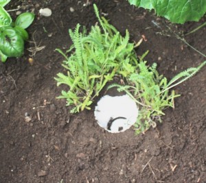
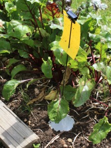
A pitfall trap with Yarrow planted around it.

My “control” pitfall and sticky traps.

For the pit-fall traps, we are instructed to only count the beetles, and to compare the beetles we see to an identification guide we are provided. Our main target are ground beetles of the Carabidae family. These guys eat many common garden pests like caterpillars, aphids, and slugs. Identifying the genus of the beetles we catch is the fun part of the exercise. The sticky traps have to be counted by experts working with microscopes back at the lab, so we just collect and catalogue those.
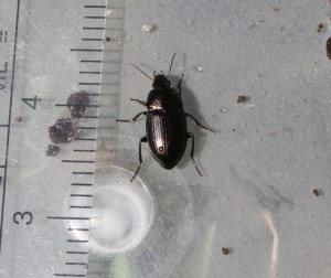
One of the beetles I trapped and counted in week 1. He was subsequently released.

There are UNIBUG volunteers across the Lower Mainland (keeping Dr. Ronnie running around keeping things running smoothly!), and here in New West, we have volunteers with yard gardens (like me) and several volunteers at each of the City’s three Community Gardens. With us all entering data on-line every week, and collecting stickytrap each week, I see a lot of lab time crunching data in Dr. Ronnie’s future. We get the fun part, she has to do the grunt work. The glory of a career in science!
Cities and Carbon credits.

We all agree that anthropogenic climate change is happening, and that Canada is one of the worlds worst offenders per capita (If not, perhaps you should review a bit of this and come back later). The question is what are we going to do about it?

Carbon Offsets are one of those ideas that might sort of work, much like a carbon tax, but their success and usefulness depends on very careful legislation. The problem is, in our hyper-policial world where logic and science rarely come into play during he drafting of legislation, they can seriously go wrong. I present to you as evidence, the Pacific Carbon Trust.

Some of you may know about the Climate Action Charter. This makes all local governments who “voluntarily sign” the charter, to be “carbon neutral” by 2012. Of course, it isn’t really voluntary, as these communities are offered a 100% rebate of the carbon taxes they pay if they fulfill this commitment. There is some strange calculus between reducing the carbon they use to the point where the savings in the taxes offset the extra carbon offsets you need to buy to get back to “carbon neutral”, but I leave that for the accountants.

The end result or this coercion is that Cities do often-good sometimes-questionable actions to reduce their carbon use. Retrofitting City buildings to be more energy efficient, introducing anti-idle policies and investing in a more efficient fleet of vehicles to line up around the token guy with the shovel, creating District Energy Utilities where the City’s ice rink takes all the waste heat it creates making ice and uses it to heat the water in adjacent swimming pool. You can also throw in building compact, transportation-efficient cities. These are all reasonable measures that should save taxpayers money in the long run and reduce the need to oxidize hydrocarbons. These are good things.

(Notably, one of any City’s largest green house gas producing activities is the generation and disposal of solid waste, and that is exempt from the Charter. I could go on…)

Recognizing that Cities can’t just stop burning fuel tomorrow, there is en expectation that Cities will use carbon offsets. This idea being that organizations that make money producing carbon dioxide can be provided economic incentives to not produce so much carbon dioxide, and sell that non-production of carbon dioxide to someone who cannot help but produce carbon dioxide. So for every tonne of carbon dioxide that a City produces, it will pay $25 to someone else to not produce a tonne of carbon dioxide. Alternately, they could just pay the $25 in carbon tax to the Provincial coffers.

I have had discussions with Municipal Energy Managers and GHG-reduction experts who are convinced this is a good idea for all kinds of traditional economics reasons. It is, they argue, the same as carbon tax, in that is puts a “cost” upon the production of pollution that can be used to directly reduce pollution. There are also some significant GHG Experts who think it is a terrible idea.

However, much like our completely misguided and ineffective carbon tax (another topic), the way the offset market is managed in BC is both unproductive and ethically compromised. You see, our local governments must purchase their carbon offsets from an entity known as the Pacific Carbon Trust. This is a Provincial Crown Corporation that operates under the direction of Kevin Falcon. Guilt by association is never a good idea, but considering Falcon’s greatest accomplishment up to this point is the ramming through of the largest climate crime of the last decade in this province, well, we know GHG reduction is not really a priority of his.

That said, we can measure the Pacific Carbon Trust for what it does, without worrying about the Falcon taint. After all, it is a public reporting company, and every person who pays property or school taxes in the Province is going to be buying carbon credits from the PCT, so let’s see where it is a going.

The PCT’s two largest offset purchases so far are from TimberWest (about $7.5 Million) and EnCana ($2 Million).

Timberwest is getting paid off by choosing not to log less than 8% of their 300,000 Ha of forest on Vancouver Island. The fact this area has not been logged up to here is pretty compelling evidence that it was not economical to log, either due to access issues, riparian protection laws, or political sensitivity. Reading the project summary is a twisted journey into justification. You see, they are anticipating a future “acceleration” in logging, after the current pine-beetle-harvest-glut of lumber passes, and they are committing to not accelerating in the future quite so much: a hypothetical agreement to reduce by 8% their future hypothetical logging based on hypothetical future market conditions. For this, our Cities and Schools have shipped them $7,500,000, so far.

I say “so far” because according to the report, TimberWest figures it will be offsetting up to half a million tonnes of carbon a year for perpetuity. That means taxpayers will be throwing up to $12,000,000 a year to Timberwest not to log trees they admit are not economical to log due to the glut of lumber on the market, presumably until the market forces them to “accelerate”, at which time they will probably find it more profitable to cut the trees that perpetuate the offset myth.

Now TimberWest is an interesting organization. It is mostly the investment wing of a bunch of public service and private pension funds (which means, ironically, that I am probably benefiting directly from this scheme, having a public service pension, but as a minor fouth-tier “shareholder”, have no say whateoever in its operations). However other “we promise not to log (this week)” deals with the PCT have been signed across the province.

The EnCana deal is even uglier. EnCana is one of Canada’s largest oil and gas companies, and is one of the largest natural gas companies in North America. They produce about $6 Billion in revenue per year, and are currently building the largest office tower in Western Canada. The BC government gave then $2 Million for a program where they capture residual gas from their drilling operations and use it instead of just flaring it off. The end result? That gas ends up in a pipeline, and is sold by EnCana.

In a rational world, the Province would pass a simple piece of legislation that says gas drillers cannot flare gas at their drill sites, but instead need to capture it. That gas is a provincial resource, we can pass any law we want about how it is managed, including insisting that if you are going to pull it out of the ground, you are going to sell it, not let it flare. Clearly, the technology to do this exists. Instead, we are paying a large profitable multi-national company to put gas in a pipe and sell it on the open market. We are paying them with your property taxes. And let us not forget, this gas is not being sequestered, every bit of that gas is still going to get burned and go into the atmosphere, it is just going to be sold to generate profit before being burned instead of being immediately flared.

So, what is my point? I am one of those people who think that the largest, most profitable companies in Canada do not need handouts from our municipal taxpayers and school boards. Therefore, I think the City/School board should take every measure to reduce their GHG emissions. Then they should fairly account their residual carbon, and pay the carbon tax to the provincial government. I would rather my tax dollars go to fund government services than line the pockets of profitable companies like EnCana. I guess that makes me a raving socialist.

Bugs in the Garden – UPDATE

This has been a tough year for the garden. A cool wet spring had a lot of our seeds dying in the ground. The weather also brought us slugs, snails, and aphids. The first crop of lettuce expired, as did the first attempt at carrots. The beets and radishes got eaten by slugs. Radishes wormed-through. I am a terrible gardener.
??

By the Middle of June, not much was happening. Besdies the Garlic and the two “vounteer” potatoes, everything seen was transplants sprouted inside.

??Besides the weather, a constant issue in my garden is the combined aphid-ant battle. I learned last year that some species of ants actually farm aphids. The aphids apparently take more sugar-filled sap out of some plants than they can digest, so they…uh… pass a very sugar-rich waste that the ants harvest. Ants “milk” the aphids like we do cows. This is so successful that the ants have actually learned to farm the aphids. They move small aphids from one part of a plant to another to spread around the feeding space, they even defend the aphids from predators. My attempts to dissuade the ants from my plants, using tanglefoot on my blueberries, and diatomaceous earth on my sunflowers, were to no avail. Using a spray-bottle or water to knock the aphids off was pretty effective, until the ants replaced the lost flock with more young aphids. I just don’t have the time to do it every day. I’m a terrible gardener.

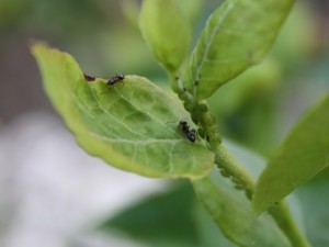
Ants and aphids working together to kill my bluberry plant. (click to zoom).

The problem with using anything more powerful (even insecticidal soap) is that it tends to knock down the natural enemies that control aphids and ants and other pests. The natural enemy of the aphid is the lady bug. So every time I see a lady bug in the garden, I know it is on my side. My experiences with ladybugs this year have included the whole life cycle.

Back in June I found a bunch of ladybug eggs on one of my sunflower plants:

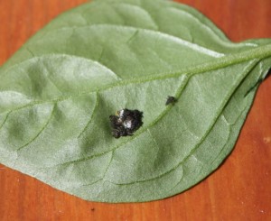
Not long after, I found a bunch of freshly-hatched ladybug larvae on a leaf on my pepper plants:

Problem is, my pepper plants are amongst my tomatoes on the hot back deck, and the only two plants not being nuked by aphids. So I took matters into my own hands. I clipped the leaf off the pepper plant and attached it with a twist-tie to an aphid-infested blueberry plant in my front yard. I hoped the larvae would find a quick bounty, and stick around the garden patch where they were most needed.

That is where I learned about the ants and their defensive skills. 10 minutes after moving the leaf, there were a half dozen ants on the leaf, attacking the freshly hatched larvae. Oops. I moved the leaf to safer spot, and hopefully some of them survived! When they get big enough to defend themselves, the larvae are pretty cool looking:

And I can announce now that the weather has turned, there is a good population of ladybugs in my garden, and the aphids are almost gone completely. I still see a lot of ants around, and the sunflowers seem to have some aphids, but they are big enough to defend themselves, and they seem to be just populous enough to keep the ladybugs fed.

Oh, and now that the weather has turned, the garden is booming. Too late to get too much off the tomatoes this year I expect, but the beets, carrots, cukes and zuchs, the garlic, the blueberries, the potatoes and the onions seems to be going gangbusters, and the herb garden is loving the summer. We may even get a pumpkin to survive. Unfortunately, lettuce has been hit-and-miss this year, after a really successful last season. I really don’t know what I am doing. It sure is fun learning.

It looks like about two weeks until Fig Season, the greatest week of the year.

I am also taking part in a community science project being sponsored by Douglas College’s Institute of Urban Ecology, but I’ll talk about that later. If you are on Facebook, you can check it out now.

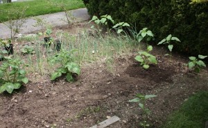
First update: That picture at the top shows what the garden was like inJune, with the late start, here is what it looks like now:

Second Update: I did a little research into Lady bugs, and I am supposing that little bug I photographed above is actually not a native ladybug, it is likely Harmonia axyridis, or a Japanese multi-colour ladybug. OK, because they eat a lot of aphids. but bad because are apparently displacing native species that might be better adapted to our climate. An interesting peice of background on native vs. introduced ladybugs. good reading!.

Green Party and EMF 2.0

After yesterday’s winge, I have to give props to Elizabeth May for addressing the EMF issue head-on. I disagree with her position (as do a lot of other Green supporters, based on the responses to her post), but she isn’t ducking and hiding. Instead, she is providing the rationale for her position, and providing a set of independent data that supports her position, allowing those interested to make their own, more informed judgements. This is what an accountable politician should do. Contrast this with the Conservative approach when they are challenged to provide background or scientific analysis of any of their policies!

People are right to point out the flaw in the Federal Green Party approach to this issue. According to Elizabeth May: “There is no scientific consensus on EMF and health.” That should sound eerily familiar, as this is the central argument used by Climate Change Deniers: there is no scientific consensus. To support this, she provides links to a couple of recent studies, yet completely disregards the thousands of studies on the biological effects of electricity, magnetic fields, and non-ionizing electromagnetic radiation that have been done over the last 100 years. This is the equivalent of arguing that Anthropogenic Global Warming is not happening because a paper came out in Nature suggesting Mars has experienced some warming over the last decade (yes, this is an actual argument you can find in the climate change denier crowd). There is scientific consensus on these topics, and just like the consensus that our planet is an oblate spheroid and circles the sun, there will never be unanimous agreement. Few are those who can win an argument against a dedicated flat-earther.

May often talks about the “precautionary principle”, and brings it up in this debate. The problem is that the principle can not rationally be applied until we pass a threshold of plausibility. Sleeping with your lights on to avoid the monsters under your bed is not precautionary (who can prove there aren’t invisible monsters!?!), it is silly. Similarly, there is no plausible link between WiFi and the list of ills Magda Havas applies to them. We know this, because the technology behind cell phones, WiFi, Smart Meters, etc. is nothing new. Sure, the actual device is new, but they are not generating any magic waves that humans have not generated for more than 100 years. Nokia didn’t invent microwave communication, they just put it in a colourful compact package. They also happen to be the same waves that the sun sends our way every day. The scientific body of evidence exists, and the day-to-day experience with actual EMF-generating equipment throughout our lives has demonstrated that they do not cause cancer, MS, Alzheimer’s, ADD, planters warts, or whatever Magda Havas is claiming they cause this week. We also have no plausible mechanism offered through which non-ionizing radiation can cause any of these ills, and none offered by the people claiming a link. This is very far from any plausibility threshold.

That said, let’s not lose track of the BC Green Party issue. Jane Sterk is not suggesting limiting cell phone transmitter power, or buffering cell towers from residential areas, or banning cell phones from kids, she is talking about putting what is essentially a cell phone on the wall of your house that will transmit data for less than a minute a day. Your exposure to EMF from this device will be equivalent to sitting in the same SkyTrain car as a cell phone user for one minute, or sitting at a stop light when the guy in the car next to you is texting his friend. And on this basis, the Green Party is opposing what is essentially an energy conservation measure, is distracting from other, possibly valid, concerns about the Smart Meter program, and is giving a grifter like Magda Havas a platform.

Although I have not heard an official announcement, a friend connected to the BC party has suggested that the Party leadership has recognized this might have been a mis-step, and they are discussing changes in their protocols to verify the professional credentials and the quality of the research and publications of the experts they use to help guide their policy. This is a good sign. We all make mistakes, but the true measure is how we learn from them, and how we adapt in light of them.

oh, and XKCD, once again, has it right:

East Point Geology

As I have noted before, in one of the earlier lives I was a geologist. Like most people who are once geologists, I am always thinking like a geologist, in that I can never walk by a rock without looking sideways at it, and making up stories in my head as to its origin.
A summer long weekend on the Gulf Islands (the Canada Day Lamb Roast on Saturna Island is a family tradition, going on long enough now that I have an assigned volunteer role) gets me looking at rocks again, and rocks I know well and love.
I actually did my Master’s Thesis looking at rocks of the Nanaimo Group on the Gulf Islands, so I have a particular affinity to Upper Cretaceous sedimentary rocks, and always see the sandstones, conglomerates and mudstones of the Gulf Islands as “my rocks”.
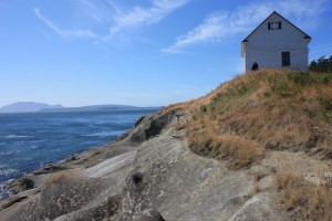
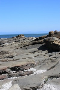
On Saturna, I spend most of my time out on East Point, where the exposures of the Geoffrey Formation are dominant. This is a very late Cretaceous set of rocks, probably 75 million years old. For context, 75 Million years ago there were dinosaurs walking about, all the mammals in the world were shrew-sized or smaller, and the dominant form of sea life was various hard-shelled cephalopods we call ammonites. The Coast mountains were actively building up, as were the Rockies, and the coast was much more like the west coast of Chile is now, with the mountains the size and scale of the Andes, and a deep subduction trench off the coast. Vancouver Island was, for all intents and purposes, not there.

There is some debate about where these Nanaimo Group rocks were, geography-wise, when they were deposited. There is no doubt they were deposited into an ocean, facing west, near a coast open enough that they were subjected to large hurricane-force storms on a regular basis. Most of the geology and the palaeontology suggest they formed in the temperate Proto-Pacific (just a little south of where they are now), but there is a pretty interesting body of geophysical data suggesting they were much further south in the tropics, around present-day Baja Mexico, when they were formed. The “Baja-BC Hypothesis”. I for one side with the geologists over the geophysicists, purely on a weight-of-evidence argument, but that is neither here nor there.

The Geoffrey Formation rocks of Saturna were deposited as part of a submarine fan complex. They were deposited in the ocean, deep enough that surface waves, even during the biggest storms, did not effect the sediments on the ocean floor. They were influenced, however, by large submarine “turbidity flows”, or large landslide-like events that occur occasionally in the ocean. Walking along the shores of Saturna, the evidence of these events is written large on the rocks.

In the ocean, sediments are deposited fairly slowly. As the currents away from the shore are pretty gentle, it is only fine materials like silt and clay that get out there to be deposited. The sand and coarser material is washed around on the beaches and near the shore, and is constantly re-worked by wind and wave and bugs in the soils, but there just isn’t enough wave energy to move them our very far out into the ocean. The exceptions are big storms, which can ramp up enough of the wave energy to move much of the sand and gravel built up on the beaches further out to sea, or big flood events along deltas, when there is a big migration of river sand out to the delta front. For the most part, however, the coarser sediments get to the shore (or just offshore) and basically stay there, building up over time into big, unstable, shelves of loose material.

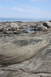
To quote Thom Yorke: gravity always wins. When these shelves build up large enough, they eventually begin to fail along submarine canyons. When large amounts of water-saturated sand and silt, with a little gravel mixed in, begin to move under water and flow down these submarine canyons, they do so in the form of “turbidity currents”. These high-speed flows of are a lot like the “mudslide” that just buried Highway 1, but because they are underwater and are water-saturated, they behave very differently. The turbidity of their flow keeps them suspended on a laminar base, and they can therefore move very far along a shallow slope with little energy loss. Most remarkable is what happens when friction rises to a critical point and overwhelms the forces keeping the flow moving: the sediments almost instantly “freeze” in place. This makes them very distinctive from river sands or beach sands or even dunes in a desert, where the constant working by currents result in complex structures like cross beds and dunes and ripples.

Fancy as this may sound, I’m not making this shit up. We know these things happen because we can go to places like the modern Indus Fan or even the Mendocino Trench and see these things operating today. Geology is great that way: uniformitarianism rules all.

Even more fun with the submarine fans is that the material they transport can include the fine gravel or coarse sand moved out to the shelf by floods or storms, along with the layers of fine mud deposited in the calm deep ocean, and fossils from boththe shallow water and from the deep water, and even pieces of terrestrial plants like logs and leaves, flushed into the shallow ocean, all mixed together in a chaotic matrix. At East Point on Saturna Island, we can see the deposits of all this.

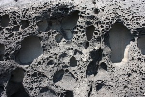
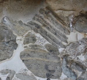
Mostly, the Geoffrey Formation sandstones at East Point are thick and massive, with only minor interbeds of pebble to cobble conglomerate, and only widely dispersed silty mudstone layers. The sandstone represents the bulk of the material stored along the shoreline (not too dissimilar to the sand built up off the coast of Vancouver Island now, to hundreds of metres of depth), and the bulk of the material that filled those submarine channels when there were turbidity flows, and they are the material that sometimes “froze in place”. These massive sandstone beds (“massive” in geology does not mean it is really big, it means that the entire bed is homogenous, without cross beds or ripple marks or bedding planes) are the beds that tend to erode in a pattern known as “taphoni” or honeycomb weathering, one of the most distinctive features of the sandstone of the Gulf Islands.

“taphony” weathering

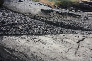
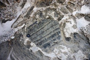
There are also a few conglomerate beds mixed in with these sandstones, where material from closer to shore was swept out though one of these long canyons. This material is more dense than sandstone, so it concentrates along the bottom of the flow, where it erodes into the underlying sand material and creates a sharp contact on the bottom of the bed. Sometimes other material is mixed in with the gravel, especially shell material, now fossilized.

Gravel bed, note “sharp” contact at bottom where gravel eroded into soft sand, and more gradual shift to sand on top.
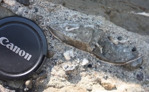
That big oval to the right of the lens cap is actually a section through a bivalve shell, which got broken up as it moved along with the graveland sand, but preserved finer mud material from where it was living within it’s hollow. I’m not a paleontologist, but that there is a ~70 Million year old clam of some sort.

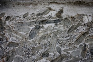
But on the south edge of East point, down by the water is a really special bed. Collected along the bottom of a bed are polygonal hunks of mudstone. These chunks often have bedding structures within them, showing the mud was laid down gently over time, with only the faintest traces of currents in thin silty interbeds. Often, there are trace fossils, showing that some type or animal eked out some meagre existence within those mud beds.

Note the bedding is only within the chunk of mud, which is oriented chaotically compared to the sandstone beds, and compared to the bedding in other chunks of mud. Also, the edges of the mud chunk are broken up, or even bent. These big mud balls are colloquially called “rip-up clasts”. They are literally hunks of soft sediment deposited on calm water then ripped up by the turbidity current and swept along in the flow. We know they were pretty firm and compacted, because they didn’t completely break up in the flow but remained cohesive and moved along like a wet pile of cardboard. We know they were soft sediment and not “rock” because they were easily folded, bent and had their edges eroded by the flow. They are mud, so they are denser than the saturated sand, and collect towards the bottom of the flows, and are mixed in with gravels and fossil fragments. When the flow stopped, they were “frozen in place”, without the ability to fall into a layers. The result is some pretty amazing patterns:

So there I was, on a Gulf Island long weekend, looking at a rock sideways and making up stories of their origin. Drives the iCandy crazy.

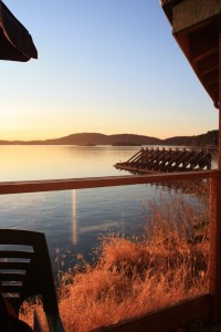
Ubiquitous Gulf-Island-sunset-from-the-pub shot.

Geology and Climate Denial

In one of my earlier lives, I was a geologist.

Once a geologist, you sort of always are a geologist. It gets in your brain. I am going down the Grand Canyon next week with a friend who happens to be a Professor of Earth Sciences, and we plan to spend a lot of time cracking rocks and talking stratigraphy. I have already downloaded geologic sections and taken prep notes on the major units, their interpreted settings and anticipated trace fossil assemblages. I do this stuff for fun. However, in an earlier life, I actually did geology for a living, not as a hobby.

 As a geologist, I was member of the Geological Association of Canada, attended several of their meetings, and even presented at one of them (and had my presentation topic expanded into a paper in a special volume of the Canadian Journal of Earth Sciences published by the GAC).
 As a sedimentology student, I also read a whole lot of Andrew Miall. His “Principles of Sedimentary Basin Analysis” is in every sedimentologist’s bookcase, along with a raft of his papers on fluvial sedimentology (the deposits left by rivers). I cited that book and two other Miall papers in my Masters thesis, relying on his descriptions of alluvial fan deposits to interpret some of the facies in my field area, his description of bi-modal clast distributions resulting from traction flows, and his interpretations of peripheral foreland basin deposit sequences. He is a giant on the subject of the geology of terrestrial sedimentary basins, and a petroleum geologist of significance world-wide, not just in Canada.
 So it is remarkably disappointing to read about this year’ Annual GAC meeting, and to see the symposium entitled “Earth Climate: past, present, and future”, chaired by none other than Andrew Miall.
 The subject itself is topical, interesting, and well within the scope of geology (Geologists are the most qualified to interpret historical climate indicators, working with paleontologists, palynologists, isotope geochemists, and other fields that fit loosely under the big tent of Geology- the study of the solid earth.) The problem arrives in the outline for the symposium . Every line of it makes me cringe: 

“The scientific debate about climate change is far from over.”

Lifting this language right from the Climate Denier playbook, it is clear from the opening line the approach that will be taken below. This line pre-supposes that there is a single debate about Climate Change, and by that supposition, the two positions are: A) humans are definitely causing unprecedented changes in the earth’s climate by their burning of carbon-based fossil fuels and the nations of the word need to take immediate and drastic action to reduce atmospheric CO2 or face significant social, environmental and economic consequences; and B) wrong. 

“Some of the projections of climate change and its consequences contained in the 2007 Report of the Intergovernmental Panel on Climate Change (IPCC) have been called into question.”

Ugh. Yes they have. Admittedly, the 2007 report put out by the IPCC got a few things wrong, or failed to fully support a few of the statements within. And there has been a lot of science done since 2007, some of which matches the IPCC projections, some of it that suggests the IPCC projections were pessimistic, and the majority suggesting the IPCC projections underestimated the scale of the problem. But the IPCC report is a single document in a sea of research, and of all the documents, it is the most politically tainted. Why single this one out for discussion in a scientific meeting in 2011?

“This symposium will address some of these issues and present a geological perspective on the scientific debate. “

Good, Geology has lots to say about historic climate conditions. Sounds like an important topic to discuss.

“For example, what is the relative importance of water vapour versus carbon dioxide as a medium of heat retention in the atmosphere?”

Huh!?! H2O vs. CO2 in the atmosphere? How is that a geologic topic? This is simple chemistry and physics, we know H2O is a larger greenhouse gas than CO2, no geology required. The only reason this topic is being brought up is because it is a favourite amongst climate deniers, even after it has been thoroughly debunked. This topic has no relation whatsoever to the “climate debate”, it is a red herring. 

“How important have variations in solar output and in sunspot levels been in determining energy input to the Earth’s atmosphere?”

Huh!?! Is this even a debate? More solar output means more input to the Earth’s atmosphere, the relationship is linear. This is not a debate (and not really a geology topic either, although some geologic methods allow estimation of historic solar output directly or by proxy). Another red herring. Of course, this is not in any way relevant to the current observed warming, but they digress. 

“Is the current global temperature regime now warmer than the Medieval Warm Period or the Holocene Hypsithermal?”

OK, This is an excellent topic for geologic investigation. We should be able to use our multiple lines of geologic evidence (although these events are so recent, it is more pedology than geology) to determine the straight-forward answer to this question. I’m not sure what the relevance is… oh, wait, here it comes….

“This is a significant question, given that many damaging ecological, faunal and weather changes have been predicted based on such warming. Yet Earth and its assemblage of life forms clearly survived these and even earlier exceptionally warm periods.”

Here is where the real intellectual dishonesty comes in. Yep, the Earth survived climate change in the past. Actually, at the end of the Maastrichtian, it survived a pretty big climate disruption. Of course nothing larger than a chicken survived, all the planet’s apex predators were killed, the dominant form of sea life was made extinct, along with 90% of vertebrate species, but hey, the earth and life went on. That said, I don’t think any of us want to experience that type of event in our lifetime.

As for the events he actually cited, the MWP was probably (and I say probably, as there is actually some debate in the mainstream scientific community on this) not warmer than today globally. It was certainly as warm as today in Northern Europe, and certainly cooler than today in regions of the tropical south Pacific, but the global temperature average is not as well established. It is also important to know that start and end of the MWP in northern Europe were gradual events, taking centuries for any change to become apparent, and they nonetheless cause huge disruptions to society, to food supplies, and to the natural environment. The current measured warming is happening at a rate 50-100x that rate. How will we adapt this time? 

“Is it possible that other causes, such as the density and ubiquity of the human presence on Earth, rather than climate change, may be the cause of the observed deterioration in many environmental indicators?”

Huh? Is this a geologic topic? Is this really what a bunch of mineral and petroleum geologists should be studying? And what the hell is implied by the question? That overpopulation and resource use are problems we need to worry about, instead of worrying about climate change? How about we worry about both, and recognize they are both the same freaking problem!

Ok, so Miall wrote a provocative abstract to attract an audience to his symposium. You don’t get to be an eminent Petroleum geologist with out a few sales skills. Luckily, the GAC provides abstracts on-line , so we can look through the actual presentations and pick out the real science here. Should be fun, and I will more in future posts.

But as a satart, let’s look at hte Keynote: Oh, oh. It started bad. I see the Keynote is noted Australian climate denier (and mining geologist) Ian Plimer . Looking at Plimer’s Abstract does not instill confidence. Check out how in the last paragraph, instead of summarizing findngs and speculating on implications, as one is wont to do in a scientific abstract, he uses it to pile up non-sequitor climate denier catch phrases…

“Humans have adapted to live on ice, in mountains, in the desert, in the tropics and at sea level and can adapt to future changes. During interglacials, humans have created wealth; populations grow; glaciation is heralded by famine, starvation, disease, depopulation. Humans, although not the dominant biomass of Earth, have changed the surface of the planet. Pollution kills, CO2 is plant food, H2O vapour is the main greenhouse gas. Climate models throw no new light on climate processes”

 In order, that paragraph can be summarized as:

  • Climate change isn’t a problem, we’ll adapt! (debatable) 
  • Global warming is good! (ridiculous) 
  • People have impacted the planet in many ways! (non-sequitor)
  • Pollution is bad! (generally true, but irrelevant)
  • CO2 is good, so it can’t be pollution! (does the same go for zinc?)
  • Water vapour is the problem! (demonstrably not true)
  • Climate models don’t work! (bullshit. how does he feel about mineral deposit models?

He actually pre-emptively Gish Gallops. Loads on the BS so thick, it would take more than a 40 minute keynote to address how wrong his thinking is.

I will opine more as I get time to go through the other abstracts, but I want to leave with an paraphrased quote I once heard from a paleoclimatologist I know:

“AGW is founded in Physics, all was can don in geology is test it. Unfortunately, every time geology and physics have disagreed in the past, it was always the physics that had it right”

Earthquakes, there and here. – now with extra nuclear reality check

As a geoscientist and someone who works in Richmond, I am hyperaware of the situation in Japan. I was at the curling rink at midnight last Thursday when the news came on the TV. The initial pictures of tsunami waves of debris flowing over farmlands and the shock of seeing entire oil refineries going up in flames was ultimately too harrowing to watch. I had to turn it off and go to bed. The horror on the ground was too real. Roland Emmerlich be damned.

I am in no way an “earthquake expert”, my geology training is more sedimentology and tectonics, with some ichnology thrown in and a bunch of hydrogeology experience. However, during my schooling, I was lucky enough to learn about natural hazards from a couple of the people you have seen and heard on TV and the radio in the last few days (such as John Clague at SFU, who is the go-to academic on this stuff in Vancouver, and was a very busy guy last weekend). I also had seismic course work both theoretical at SFU, and more applied at the University of Hawaii-Hilo, so I would consider myself a well informed non-expert with quite a but of related background. For what that is worth.

An event like the one in Japan will not hit Vancouver in the same way it hit Sendai. The earthquake at Sendai was a very large megathrust , one of the largest quakes ever recorded (currently the USGS has it rated at magnitude 9.0), which occurred at the very shallow depth of 10km, only 100km from the shoreline. On every single scale, that is pretty much the worst case scenario.

We do get “megathrust” quakes off the west coast of BC, and some may even hit this magnitude, but Vancouver (and even Victoria) is not like Sendai. First off, the major thrust fault plate boundary off of Vancouver Island is more than 300km from Vancouver, and more than 200km from Victoria, with the bulk of the Olympic Peninsula and Vancouver Island in the way. Also, there are up to two kilometres of soft Quaternary sediments draped over the subduction zone here, which may soften the blow a bit.

That said, a megathrust will be a bad day here in Vancouver (think magnitude 6.5 quake-type shaking, but lasting for several minutes: up to 15!), but the tsunami risk to Vancouver is relatively small (with a caveat below). The west coast of Vancouver Island will not get off so easy: Tofino, Bamfield, Port Alberni: these places stand a pretty good chance of being wiped out completely. The only real good news for them is that these events are very uncommon, probably about once every 500 to 700 years, so odds are it will not happen in our lifetimes.

Probably a much higher direct risk to Greater Vancouver is presented by much smaller “crustal” earthquakes that may occur very close to the City. These quakes are usually shallow, and if close enough, can cause major damage, although tsunamis are unlikely (with that caveat below). There are unlikely to be much higher than magnitude 7 or 7.2, but the proximity is the issue. These can happen anywhere between Hope and Sooke. This is the difference between Kobe, where most of the destruction was caused by shaking and fire, and Sendai, where most of the damage was by tsunami. Locally, this type of quake is much more likely, and probably has a recurrence interval of less than 100 years in our geographic region.

Oh, can we stop saying “Richter Scale”? No-one has used the Richter Scale for about 20 years. It is the Moment Magnitude Scale now, the difference is small, but quite signficant scientifically.

The tsunami caveat I have to include is that there could be a serious secondary tsunami, caused by a major landslide on the pacific coast (say, Sea-to-Sky area?) displacing a bunch of sea water, or even worse, a major collapse of the unconsolidated sediments off the west end of the Fraser Delta, which could hit the Gulf Islands with a serious tsunami, only to have to reflected back and hit Vancouver proper. Again, this is unlikely, but would be a bad day for everyone involved.

Which brings us to Richmond. I cannot comment for the City, nothing I say here is on behalf of the City. My job in the City is related to water quality and pollution prevention, I am not in the Engineering department, so I am not really in touch with those who do the earthquake planning. The only things I know about earthquake impacts in Richmond is from reading the City’s website on the issue, and a little bit of earthquake info I gained from my own personal research. None of this is official folks, it is just my personal, relatively uninformed position.

However, buildings and dikes are built to the 1:475 standard, which means the intensity expected once every 475 years, so essentially the worst of the “local crustal” quakes anticipated. Some critical infrastructure is built to higher standards yet. Legends of the entire Lulu Island “liquefying” are rather exaggerated. There will be local liquefaction of soils, probably resulting in some road and building damage and maybe some utility failures, but not the widespread destruction some would have you believe. Modern buildings are built with Liquefaction in mind, including piles, rafted foundations, stone columns… engineers, for all I hassle them, do good work.

The dykes, for the most part, should also be fine. Minor slumping in some of the older parts of the dykes is possible, but the internal drainage system of the Island (ditches, sewers, and pumps) can deal with that. Remember, most of Richmond I actually above sea level, unless there is a major freshet on the Fraser and an exceptionally high tide at the exact same time as the earthquake, widespread flooding is extremely unlikely even in the event of a major quake.

If anyone is really concerned about an acknowledged weak link in the Earthquake protection system, maybe ask the Provincial Governement where they are in those School upgrades.

Ask any Emergency Management expert in the province and they will tell you the #1 thing you can do to protect yourself from the inevitable earthquake is to be prepared. Have a 72-hour survival kit , because you shouldn’t anticipate getting any help in the first few days after an event. Another emergency kit (water, food, blanket) for your car, and one for your workplace will give you that extra protection, as you don’t know where you will be when it happens. Finally, plan ahead with your family and loved ones to agree to a place to reunite after the event, as you may not have phones to get in touch. The more eventualities you plan for, the more secure you and your family will be when (not if) the earthquake happens.

One interesting science side of this event was the pattern of earthquakes leading up to the big thrust that caused this disaster. In the days leading up to March 11th, there were several dozen “pre-shocks” of significant size in the area of the main earthquake, even up to magnitude 6.0. The Japanese lead the world in earthquake research (all due respect to the USGS), and this pre-quake pattern will be studied to death. There is hope we will learn more about the pre-cursors for this type of quake. A day’s warning, even 6 hours warning, would mean everything to the people of Tofino or Port Alberni. Compared to the hour or so warning Sendai had between the shaking and the tsunami, it could save thousands of life.

Not that Canada is slacking on this reaserch. The Neptune Project includes a plan to wire the entire Juan de Fuca plate, from the Pacific plate to the subduction zone, with sensitive seismometers to understand the changing stress regime of the plate. This is pretty cool, cutting edge stuff, no less remarkable or technically challenging that putting a probe in orbit around Mercury. It won’t get as much press, or course, unless it actually predicts the Megathrust and saves lives.

Update: as for the nuclear plant issue, the good sciency types at XKCD.com have made this cool chart up to give you an idea what the actual radiation risk is. Chort form: way less relevant than the tens oft housands killed in the tsunami, or the hundresd of thousands now homeless in Japan. Click to make readable.

On Blobs and politics.

The news seems bad, a toxic blob is waiting under our new waterfront park, ready to strike down our children and any fish silly enough to brave the New Westminster waterfront. Proof again that our Mayor bought a bag if cursed seeds in a pre-election rush to appease the milling hoards…

Ugh.

Contaminated Sites happen to be an area where I have some technical knowledge. Note, my information here is limited to the reports that the City have made available, and the sporadic news reports, and I am not legally entitled to provide technical advice on this, but what the hell. Everyone else has a misinformed opinion. Here is mine.

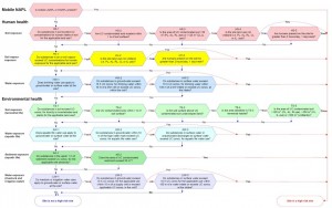
The news report that this is a “high risk” site does not mean people or fish are currently or imminently threatened by it. This is simply a procedure that all Contaminated Sites undergoing Independent Remediation go through. The evaluation involves a whole bunch of criteria. If any one of them apply, the site is determined to be “high risk”. Here is the criteria table from the Ministry of Environment:

(click to zoom it)

The list is comprehensive, but based on the media reports, it seems the trigger here is chlorinated solvents, 8m below the surface. So the only risk criterion that applies is “mobile DNAPL”. With the Ministry saying it is not getting in to the River, it seems the only pathway to the actual environment is not open. So the risk is here may be “high”, but in a future-case sense.

Nothing says anyone or anything is going to die right now from this. The classification means that there is a significant amount of contamination, and that there is potential for this contamination to cause harm.

So if you own and are cleaning up a contaminated site, what does it mean to have your site designated “high risk”? It means that the Ministry has to be informed. That’s it.

Does it mean it will cost more to clean the site? Not necessarily.
Does it mean that we have to accelerate the clean-up process, or it will take longer to clean up? Not really.
Does it mean the site has to be physically remediated and cannot undergo risk assessment and management? Nope.
Does it mean the City Park is doomed? Not yet.
Does it even mean the site is making people sick or hurting fish? Not likely.

It is also silly of Voice to suggest somehow that High Risk determination is proof that the City did not do “due diligence” in 2008. The Site Risk Classification criteria did not exist until June 2010. The City did the environmental studies it felt it required, the City knew the site was contaminated, knew the scope of the contamination as well as they could with reasonable investigation efforts, and was working on the advice of a qualified Environmental Consultant. I don’t know what else they could have done.

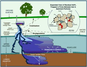
Now onto the topic of the “Toxic Blob” itself. Notwithstanding all the above, the problem is not a minor one. DNAPL (Dense, Non-Aqueous Phase Liquids) are petroleum products that are denser than water. That means that instead of going down to the water table and spreading out on top of it (like so much olive oil on the balsamic vinegar of your dippy plate at Anducci’s), this stuff sinks through the water table until it hits some layer of soil it cannot penetrate. Sometimes that layer is really far down.

This sometimes makes it difficult to manage, and challenging to clean up, as you can’t just dig down to the water table and scoop it out, like you might with fuel oil. A more technical approach is required, but, and I can not emphasize this enough, typical for waterfront brownfields in BC. These kinds of challenges were faced by Vancouver in False Creek and the Olympic Lands, Victoria at Dockside Green, North Vancouver at the Pier… I don’t think the consultants or the City were surprised to run into them here.

From the press reports, this is “chlorinated solvents”. That likely includes tetrachloroethylene (“Perc”), trichloroethylene (“TCE”), or carbon tetrachloride (“Halon 104”). To most people in Contaminated Sites work, that suggests one thing: drycleaners. There are some significant wide-area sites in BC where drycleaners (before there were strict laws about this sort of thing) dumped solvents wherever they could, and caused large contamination plumes. However, these solvents were also used widely industrially and commercially, so it will be neigh impossible to point out a single cause for this plume. And it is unlikely chasing down the source will do anyone any good anyway, as they are unlikely to be forced to pay for the clean-up. The “train derailment” theory fails Occam’s razor, as more mundane excuses (historic washing of equipment with Perc, a drycleaner located uphill in the commercial part of town, etc.) are much more likely.

Long and short: stop worrying about Blobs.

Happy Carl Sagan Day.

Science is not very good at promoting their saints. Although we have holidays and annual marketing exercises dedicated to someone who allegedly got nailed up for saying let’s all be nice to each other , ran snakes out of Ireland, or lost his head after a life dedicated to watersports , where is the single national holiday dedicated to science or scientists?

Newton Day? Einstein day, Medeleev-fest?

If we were to pick one contributor to science who deserves his own day, it would be Carl Sagan. Some people are (not surprisingly) ahead of me on this. Carl is a hero of mine, because he excelled at “real science” (so many of his early informed speculations about conditions on Mars, Venus, and the moons of the gas giants were proven to be true), at “applied science” (with his contributions to the unmanned exploration of space with the Jet Propulsion Laboratory), and most importantly, at the popularisation of science and scientific thinking. He also wrote great fiction.

He was also a vocal advocate for rational thought. Not a nebbish lab geek or aloof scientific theorist, he was always concerned about the human condition. He warned about the (at the time) poorly understood risks of nuclear war. He was outspoken about the impacts humans were having on the Earth, he was, amongst other things, a vocal, informed, and active environmentalist.

And he lived his life full of wonder. Never satisfied to say “just because” he always asked why, knowing there must be a reason. And always suggested others do the same. He wasthe personification of Douglas Adams’ quote: “I’d take the awe of understanding over the awe of ignorance any day.

My favourite quote of Carl’s:
“If you wish to make an apple pie from scratch, you must first invent the universe”
–which is just his way of saying all science is Physics.

Put to music here:

Baker Lafarge

Yesterday was one of those clear, beautiful days that makes you wonder why anyone would live anywhere other than British Columbia, hyperbolic, boastful advertising slogans notwithstanding.

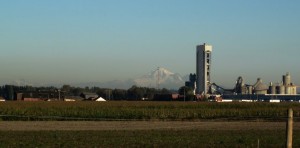
I was riding home from work along Westminster Highway, and Mount Baker was clear and bright on the horizon, providing a dramatic backdrop to the Lafarge cement plant in east Richmond. The volcanologist in me cannot see a volcano without imagining what it is going to look like when the damn thing goes off. In the case of Baker, most of MetroVancouver will have a front row seat to watch the pyroclastic extravaganza. Due to some fortunate geography, we will also avoid most (but not all) the damage caused by the inevitable lahars, ash clouds, and nuée ardente.

The plume coming off an erupting Cascade Volcano will be dramatic, and will dwarf that little Lafarge Cement Plant. Or will it? This was the question that kept rattling around in my head during the rest of my ride. How many years would that plant have to operate to generate the CO2 of a single eruption of Mount Baker.
The good people at the Cascades Volcano Observatory in Lesser Vancouver actually measured the CO2 output of Mount Saint Helens during the 2004-2005 eruptive event, and it was around 650 tonnes per day. According to the paper, the outgassing during the big eruption in 1980 was probably measured in the thousands of tonnes per day, The take-home numbers are about 200,000 tonnes of CO2 released during the big eruption in 1980, a little less than 200,000 tonnes released over the entire 2004-2005 measuring period (a period of significant eruptive and dome-building activity), and somewhat less during quiescent times. This for a volcano of similar type, size and age as Mount Baker.

As for Lafarge, according to Environment Canada , that plant puts out between 800,000 and 900,000 tonnes of CO2 every year. The last year stats are available, 2008, it was 871,000 tonnes.

I don’t mean this as an attack on Lafarge; I recognize that we need concrete in our lives, and Lafarge is an employer in our community… I just make the comparison to shed light on how our human scale is distorted; “Common Sense” is rarely either. Like all risks, we concentrate on the big, dramatic and rare events, but disregard the cumulative impact of every day life in the modern world.

More on the science of volcanoes and AGW here.