The discussions about municipal budgets are ongoing across the region, As it is budget time, and as the Province has decided to flip $1 Billion to local governments right in the middle of that budget period, which will lead to some interesting conversions in every muncipal hall. Some Councils will see it as a windfall to be spent on new things, some will use it for political cover for questionable decisions, some will prudently invest, others will go full populist. A real Marshmallow Test for local government.
Among the stories, this one popped out to me. PoCo is getting a reputation for artfully blending populism with prudent investment, but the bigger question about balancing reserves is something that every city neeeds to grapple with. The McElroy story caused me to dig deeper into reserve levels across the region, so I can test my preconceived notions about New Westminster’s relative financial health. As always, I want to preface this by saying it is not a competition, as every municipality has its own pressures, its own priorities and its own way to serve their populace. In comparing ourselves to our regional cohort, I want to get a sense of where we are doing better or worse to inform our priority setting while approving a budget.
I am once again leaning on the BC Government Local Government Financial Statistics, which are reported in a more-or-less consistent way every year. This is not my data, but the data provided by law to the Province by local governments every year. When it comes to Financial Assets, Reserves, and Tangible Capital Assets, all data is pulled form Schedules 301, 302, 404, and 503. Got a problem with the numbers? Take it up there.
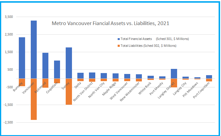
Every City reports Financial Assets (the money in their savings and chequing accounts) and their financial liabilities (their mortgages and loans). The difference between them is reported as “net financial reserves”, which is the number McElroy was pointing to in that story above. These are the reported numbers for the 17 major Municipalities in Greater Vancouver (sorry, Belcarra) in the most recent reporting year, which is the end of 2021:
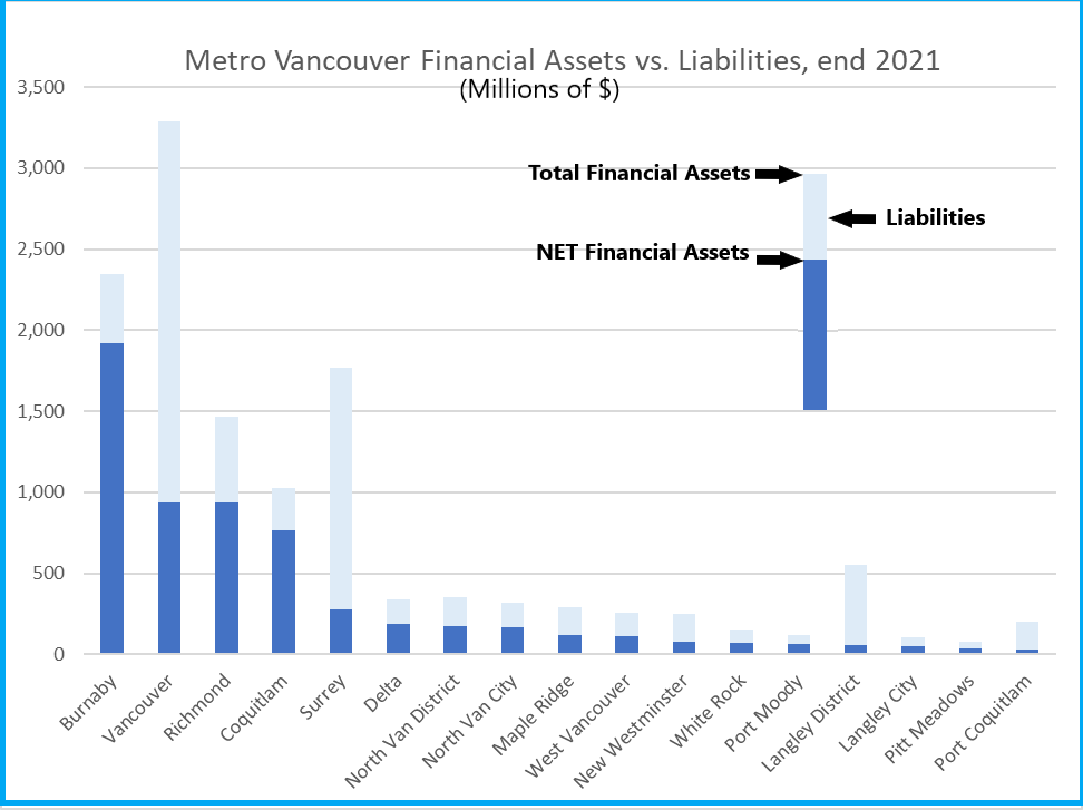
But perhaps a better way to look at it is to subtract the liabilities form the assets, so you can compare the Net Reserves:
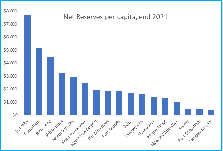
Some things are not surprising: Vancouver has the most money, and the most debt. Burnaby has the highest net neserves, and Richmond and Coquitlam are both doing really well if money-in-the-bank is your preferred measure. Indeed, PoCo has the lowest net, with New West a little below the middle, but there is a trend following population, as you might expect, with smaller Munis over on the right, larger towards the left. So let’s calculate the net reserves per capita using 2021 Census data:
Burnaby still way up there (with $7,700 in net reserves per resident), and New Westminster shifting further over to the right (with $972 per resident). PoCo in this measure is not the lowest, but is pretty closely clustered with Surrey and the Township of Langley at under $500 per resident.
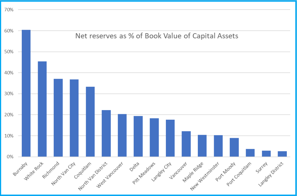
This is interesting, but does not really reflect the purpose of reserves. Part of it is to demonstrate financial health to make it easier to borrow money, but part of it is also to have sufficient cash on hand to address unexpected future costs. Mostly those costs are related to capital replacement, so it is more useful to compare your reserves to the value of your capital assets. This is the value of the roads, buildings, pipes, computers, vehicles and all of the “stuff” your City owns and operates. Schedule 503 provides these numbers as reported by the City every year. This chart shows the reserves as a percentage of the net book value of our tangible capital assets:
There needs to be a big caveat here. Though a fundamental measure of your reserves vs the value of your capital assets is a measure of financial resiliency (our finance staff have suggested 10% of the asset value is a good minimum benchmark), the denominator of the equation needs to be viewed with a certain skepticism. This is because local governments have not historically been very good at evaluating the true value of their capital assets, and that might take me down the rabbit hole of talking about asset management, which is probably another blog post on its own.
Just to create a sense of comparison, here are the net reserves per capita and relative to tangible capital assets, plotted as a scatter. Somewhere in here is a trend. I added the green dot to show the “average” for the region:
Finally, part of the conversation about reserves is the direction they are moving. Are we building them, or are we depleting them? Luckily the province provides data going back a few years in their Schedules 404. To compare across cities of varying size, I indexed the reserves value based on their 2012 value so we can see the decade-long trend. Problem is, a couple of Municipalities (Vancouver and West Van) had negative reserves in 2012, which makes it hard to compare this way, so I removed them from the data set. Suffice to say, their increase over the last decade has been proportionally much higher than all others (they would be well off the top of this chart). But for the rest of us, you can see most Munis are in building phases, and only one has fewer reseves than a decade ago:
The comparison over a decade is valuable, because reserves serve another function – they are where a City stores some money for big capital investments, like a recreation centre or a new City Hall. And when a City borrows to build a new capital asset, that downward pressure on net reserves is felt for several years. New West has been growing reserves in the last couple of years in recognition that təməsew̓txʷ and it’s $114 Million investment will have this impact on our net.
So, comparatively? New West has lower-than-average reserves by most measures, has been building them, but has a big capital investment that will put downward pressure on these reserves in the years ahead. That should inform some of our thinking about future investments in the City and our ability to make expensive promises.
Who else spent a rainy long-weekend day digging through regional housing stats?
Metro Vancouver tracks regional population and housing numbers in order to meet their mandate and track progress on the Regional Plan that the 21 member municipalities share. One of the public-facing parts of this tracking is the Housing Data Book they recently published, building on 2021 Census data and other data sources. There are graphs, maps and the tables of numbers to back them up. Its a great resource. Following on Mayor Pachal’s lead, I thought I’d look at it from a New Westminster perspective.
Thing is, regional planning is not a competition. Though I have been oft quoted suggesting that New West is more than pulling it weight on the housing front, I look through these regional stats to help understand where we are doing well, and where we need to find better solutions. So here are some graphs and maps pulled right from the Metro report, with a few comments.
There is no secret New West is growing fast. At 11.2% growth between the last two censuses, we are one of the fastest growing communities in the Lower Mainland, and growing faster than the overall regional average of 7.3%:
One interesting point about our demographics is that New West is not young or an old city, but is a millennial city. The proportion of our population between 25 and 44 years old is second only to Vancouver proper:
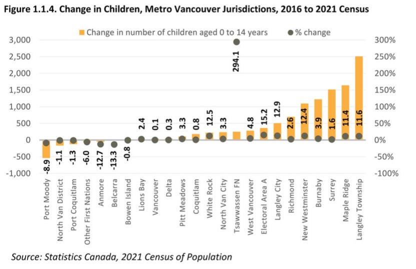
And a you might expect for a City with lots of people in that parenting age, we are one of the fastest-growing communities for the 0-14 age range (and if you want to know how we differ from Port Moody – look at that number!):
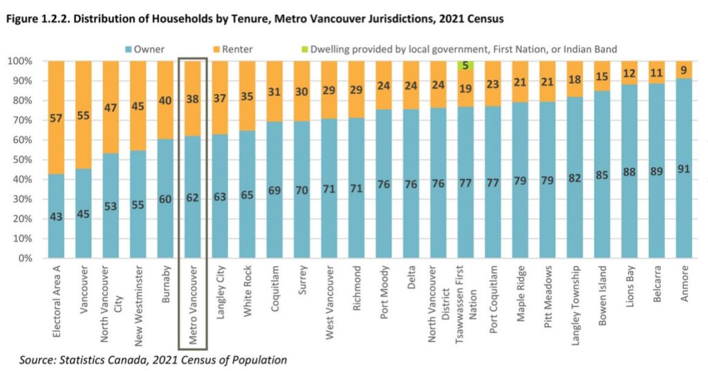
New West continues to have a proportion of rental households (45%) well above the regional average:
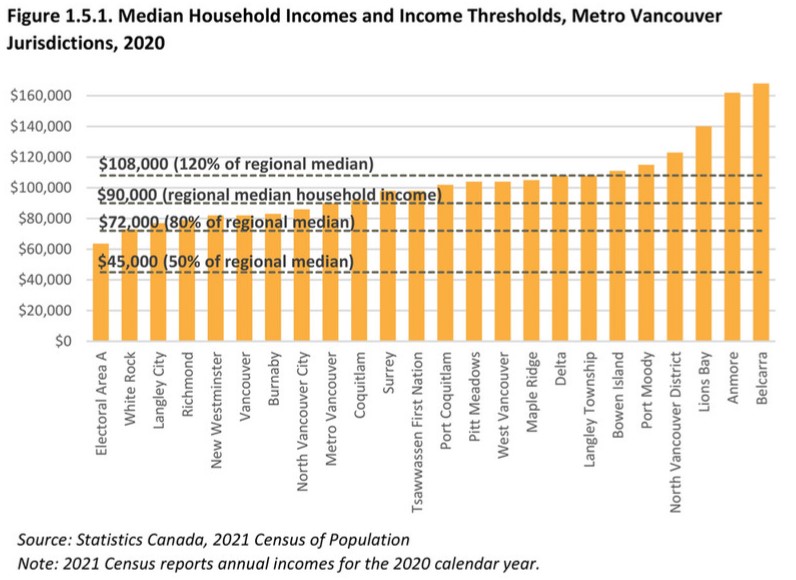
And probably a combination of those last few data points results in New West having a median household income a little lower than the average for the region ($82,000 compared to $90,000, or 9% below):
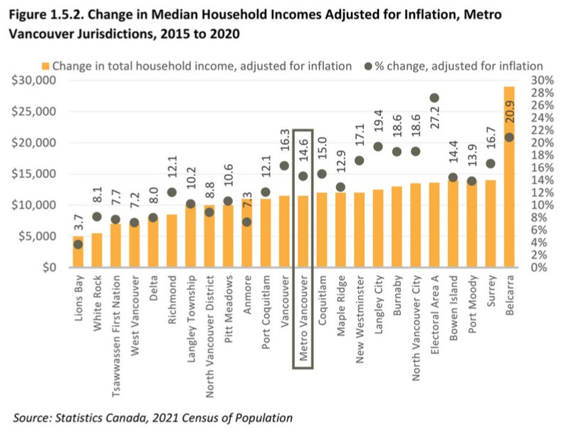
but our median household income is growing faster than the regional average:
Now, that number is interesting. Between 2015 and 2020, median household income (inflation adjusted – using 2020 constant dollars) went up 17.1%. For the fun of it, I pulled up the data from the BC government on residential property tax burden (Schedule 707 available here) and found that per-capita property taxes over the same period rose about 13%. Using this calculator to adjust for inflation, per-capita property taxes only went up 8%. In short, incomes are rising much faster than property taxes.
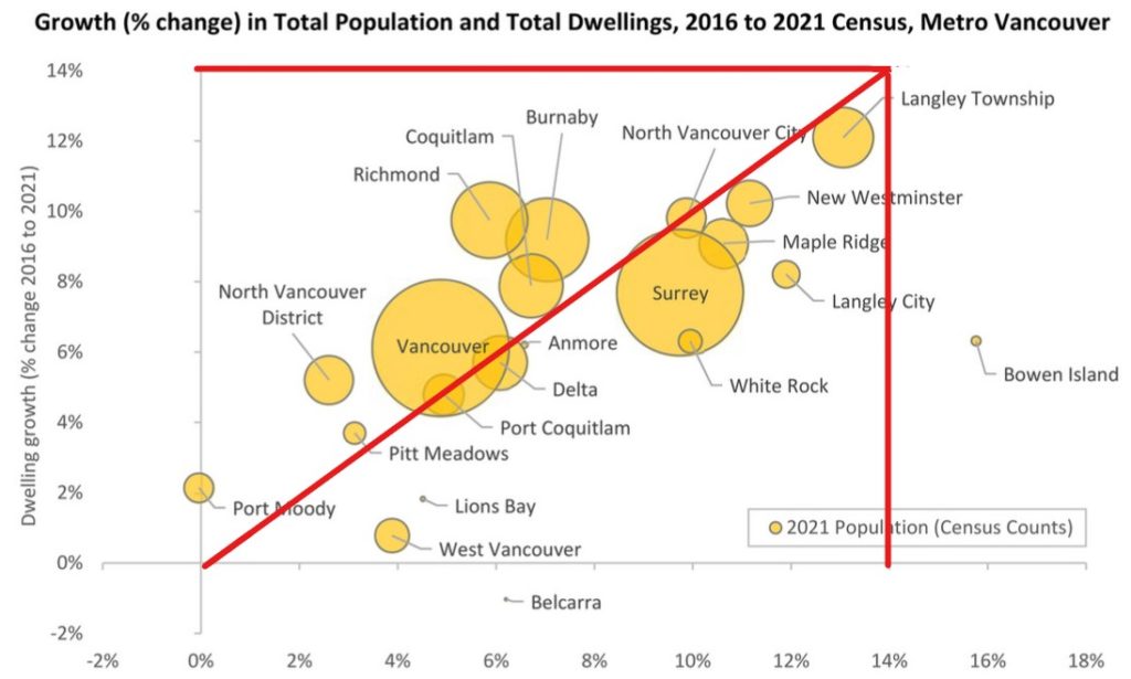
Now on to this pretty cool bubble chart, that shows the correlation between population growth and growth in the number of dwellings, with the size of the bubble representing population in 2021. I added the red lines to show what parts of the region are growing in people faster than in homes (Surrey, Langley City, West Van, and yes, New Westminster ) vs the cities where homes are being built faster than population is growing (Richmond, Burnaby and Vancouver). Again, Port Moody’s quixotic lack of growth stands out.
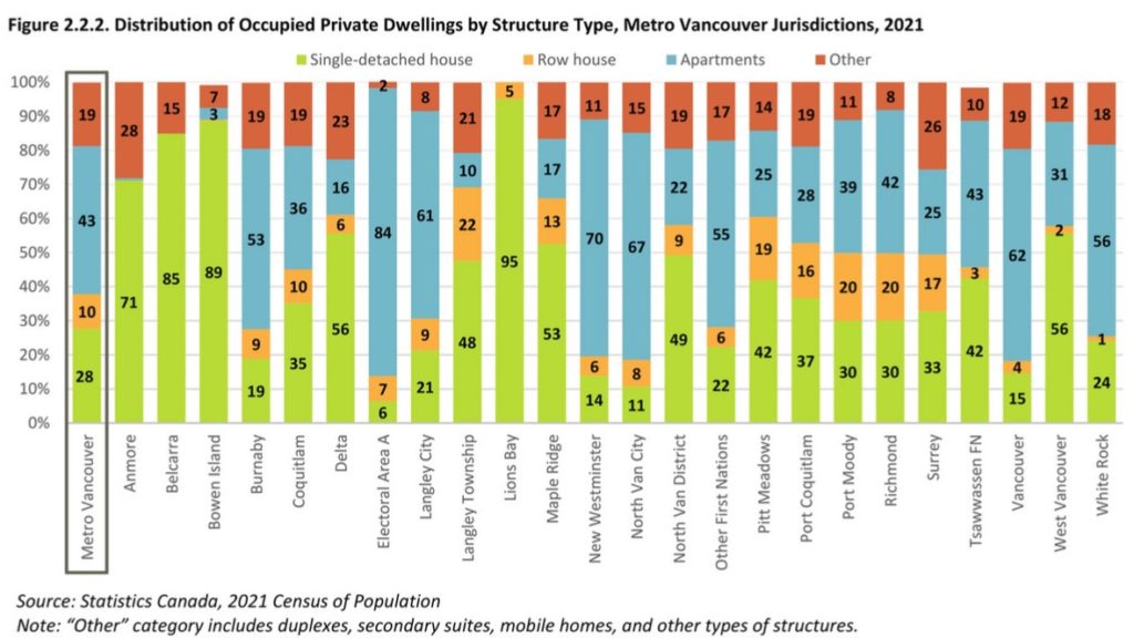
I’ll jump ahead here to housing types, and one of the big headlines is that only 14% of New West households are in a single detached home, one of the lowest proportions in the region, Note that people living in secondary suites in those homes would be counted as “other” in this statistic. The 70% living in apartments is second only to Electoral Area A (which is predominantly UBC campus, so would include a lot of student housing):
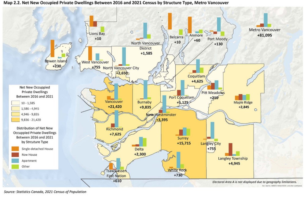
And as you might expect, almost all new homes being built in the City are in the form of apartments and rowhomes (including attached and stacked townhouses) with no net increase in single family homes (but also no real decrease either, like we see in North Van District):
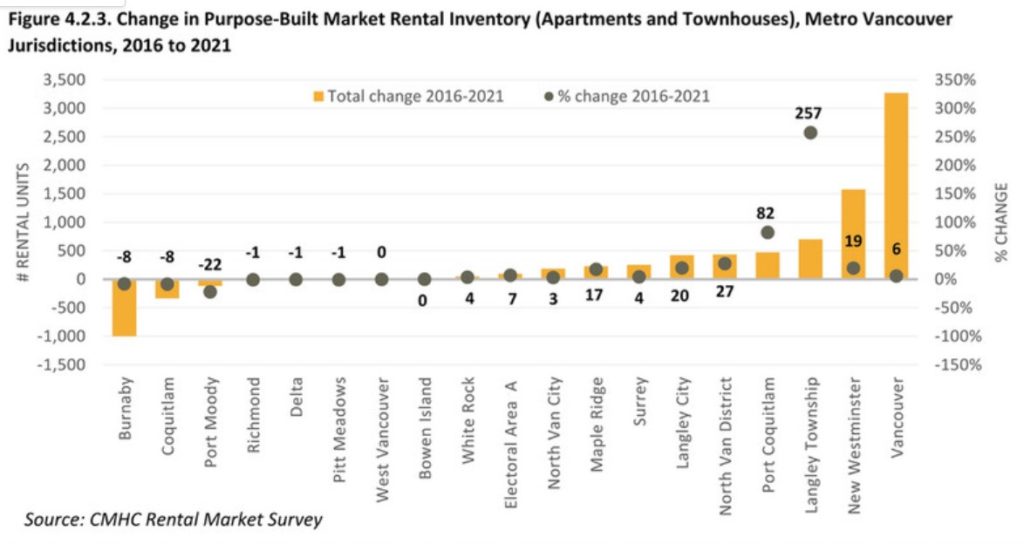
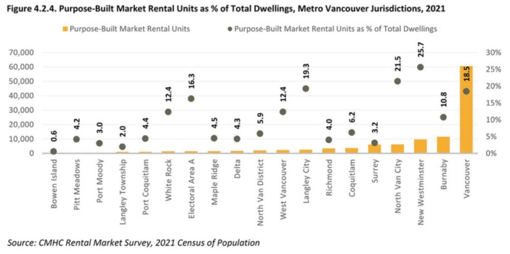
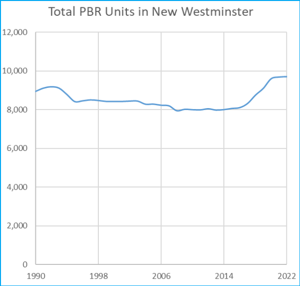
One place New West has been doing well is Purpose-Built Rental. We are getting more new rental built per capita than any other Municipality in the region, and more in raw numbers than any but Vancouver, while we are protecting the most affordable older PBR stock and are not letting it be replaced with condos (see the left part of the chart).
As a result, we now lead the region in Purpose Built Rental, with almost 26% of households in that housing type. This matters in a city where 45% of households are rental households, because PBR has one big difference over the “secondary” rental market (people renting out their condos or basement suites). That is in how they provide long-term housing security to renters. Any secondary market rental unit can leave the rental market at any time at the whim of the landlord, which is a precarious situation for the renting family. PBR brings increased housing security for the increasing number of working people in our community who cannot afford to buy.
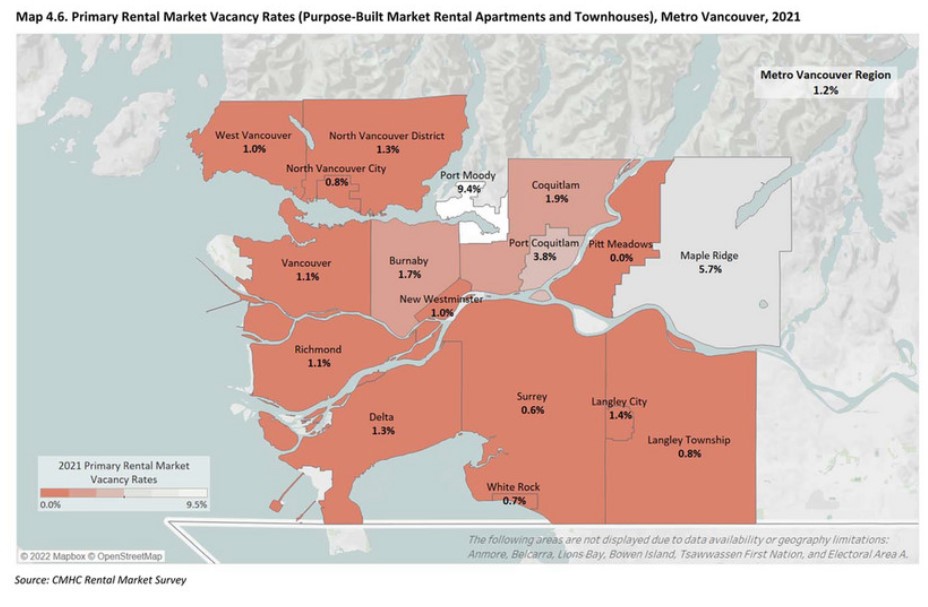
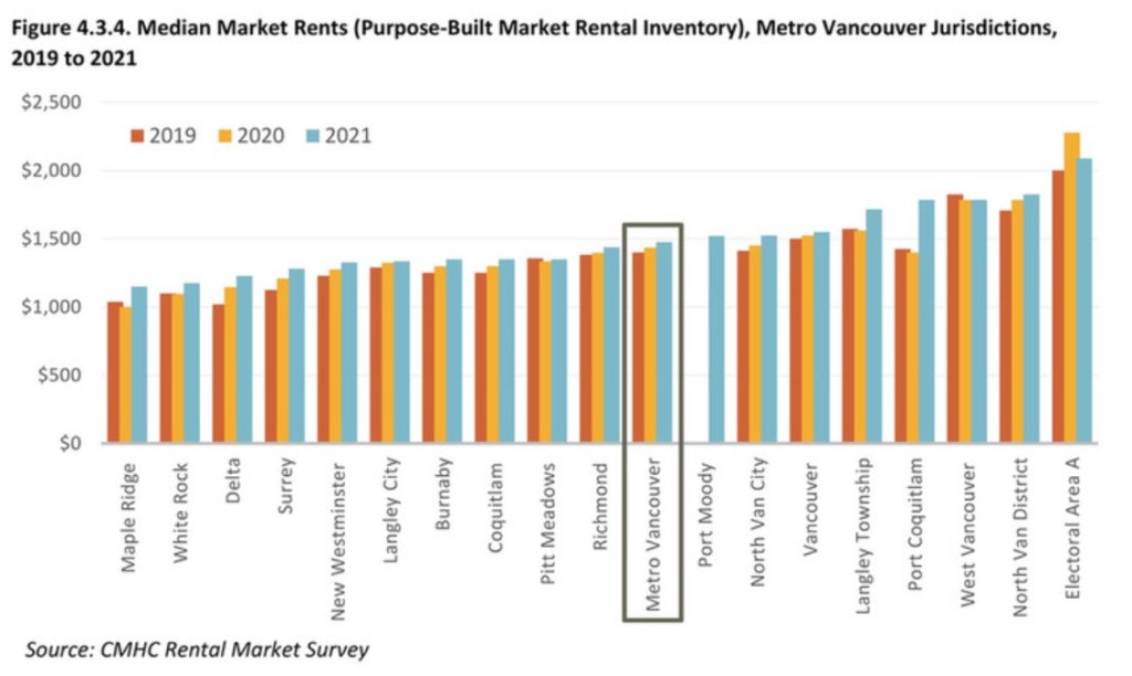
This is especially important as the Vacancy Rate is still dire:
Which means upward pressure on rents is still a problem. Though, notably, New Westminster rents are not “in the top 10 in the country”, as they are not even the top ten in Metro Vancouver:
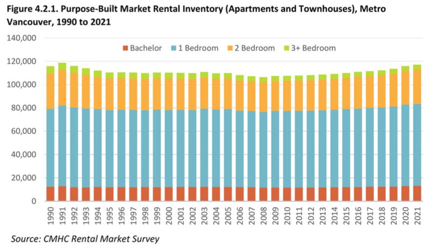
And here is why. New West cannot do it alone, our work to get us way over on the right side of those graphs above by building and protecting rental has not moved the regional needle, because we are only 3% of the population on half of 1% of the land area. When you look at rental inventory across the entire region this is the trend:
No meaningful change in raw numbers over 30 years. As the region’s population has gone from 1.5 Million people to 2.6 Million people, we have had no meaningful increase in the number of purpose-built rental homes. No wonder we are in a rental affordability crisis.
But cities don’t own all the blame here. This is largely a result of those destructive 1990’s Paul Martin budgets, when the Federal Liberal Government decided to get out of the business of housing, and of subsequent Provincial governments not stepping in to fill the gap. Without CMHC policy driving the building of new rental, with the province relying on the “the market” to fill rental need, with decades of being told home ownership is the path to financial success and tax structures that emphasize that, the market does what it does. The upward trend you see at the end is a result of the Province finally changing that two-decade practice, and (some) Local Governments shifting how we incentivize new building to make Rental viable again. But we have so much catching up to do.
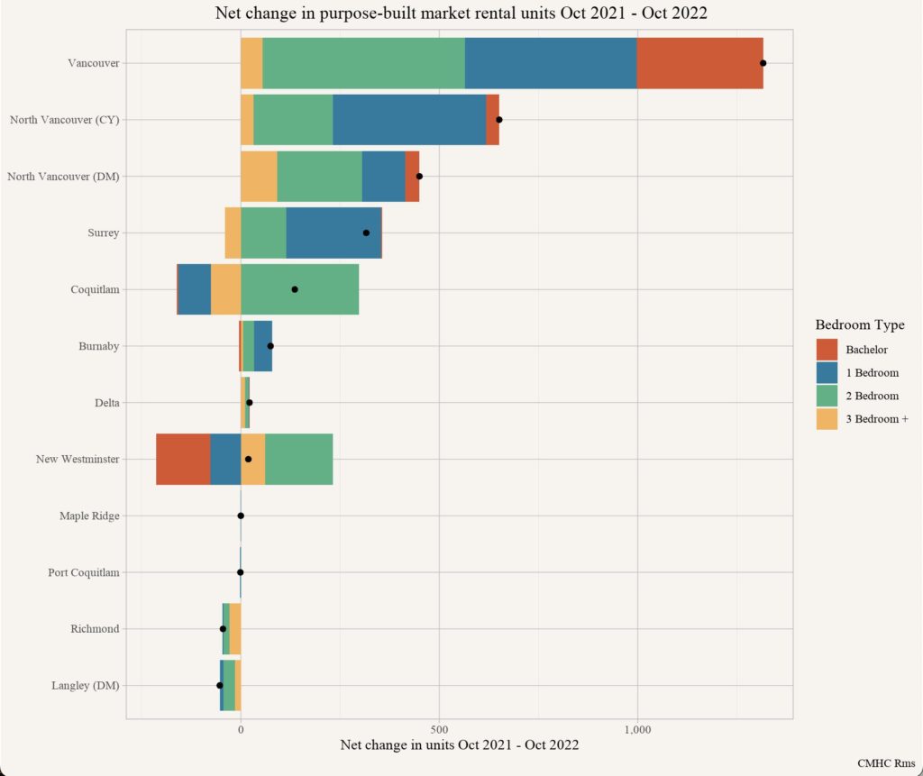
Last week there were a few stories in the regional media (traditional and social) about CMHC’s recent release of housing data. One story that got my attention was this graph posted on Twitter by census data guru Jens von Bergmann (@vb_jens):
This appeared to show New West losing a large number of bachelor and one bedroom rental suites over the 2021-2022 survey period, while 2- and 3-bedroom numbers went up, resulting in a small net increase of units. A few people asked “what’s up with New West?”, and I honestly had no idea.
Not to bury the lede: there is no way New Westminster lost hundreds of rental units over this period of time. For this to happen, there would have to be either some massive conversion of rental units to condo (not something we permit in New Westminster) or major demo- or reno-victions (both of which are tightly regulated here, and we simply have not had any such applications).
So I had to look into this, and City staff looked into it as well, and conformed what I suspected. It seems like this was a data anomaly, thought it was not immediately clear what the source of the anomaly is. This did give an excuse to dig a bit into the data, which is available here.
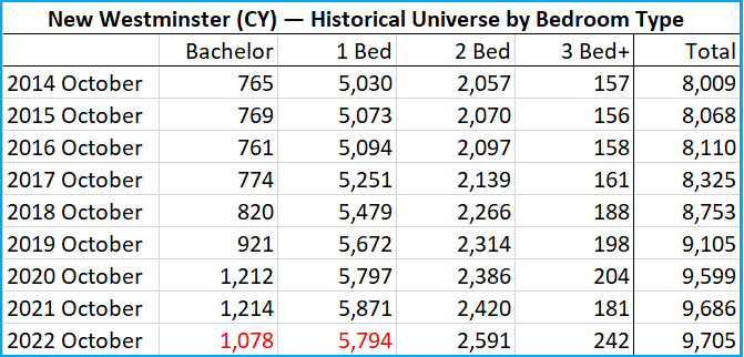
I took the numbers for rental units for not just 2021 and 2022, but for the last 8 years, essentially since I was first elected to Council. Here are the raw numbers, and I highlighted the numbers that show a decrease in the last year that is reflected in the original post:
It appears that a couple of larger Purpose Built Rental buildings were misclassified in their unit counts when they were opened in 2019 and 2020, showing the significant jump in Bachelor and 1-bedrooms over those two years, and for some unknown reason, the more accurate data is being presented now. It’s a bit complicated how we can tell this, but the short version is that CMHC also provides unit counts by census tract and by construction period (e.g. “built in 2000 or later”). This allows us to look at how a couple of larger and recently completed PBR buildings were reported in the year they opened, and in there found an anomaly. It appears both 900 Carnarvon (Completed in 2020, 172 studio, 72 1-bed, 132 2-bed, and 22 3+bed) and 228 Nelson’s Crescent (Completed 2019, 0 studio, 85 1-bed, 77 2-bed and 24 3+bed) appear to not have been entered properly, as the number of new 2- and 3-bedroom suites added do not even add up to those provided by these two buildings (and they were not the only buildings to come on line during that period). This also explains some anomalous numbers reported last year about how New West was building way more bachelor and 1-bedroom rental units than our Family Friendly Housing Policy would allow – it is the same data error, now corrected.
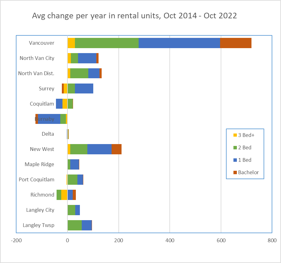
As these numbers appear to have now been adjusted, it does show that looking at one year of unit completions from CMHC data may not be the best way to compare communities or track construction/approval trends, especially for smaller cities where one or two units opening (or being mis-reported) can skew annual numbers, and hide the deeper trend. To broaden the data a bit, I looked at the last 8 years (2014- 2022), non-coincidentally the time I have been on Council. I tried to re-create Jens’ chart with the unit count change over that 8 years, divided by 8 to give us an average annual unit change over that time:
And you can see why I have been saying no-one (except Vancouver) is building more PRB than New West. Of course not all of these communities are equal in size, or in population growth (see more on that here), and these net count numbers are not adjusted for those pressures.
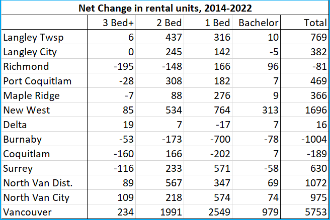
If you want to look deeper at the numbers, they are here , and you can select by City. The numbers I have used are under the “Rental Universe” tab on the left. And just for fun, and if you want to check my math, here are the total numbers I found for over the 8 years (not the per year average presented above):
In summary, one part of the housing crises that New Westminster has been very effective at addressing is the paucity of Purpose Built Rental. There were a couple of decades there from the hollowing out of Federal Housing programs to the early 2000’s where almost no new PBR was being built, and indeed it was being lost. By policy and intention, New West has turned that tide and brought more rental to the market, while preserving the older more affordable rental, with visible results:
None of this changes that rents are going up at what looks like an unsustainable rate, and a rate disconnected from regional wages. Rental availability is fundamentally regional issue, not one New Westminster (with 3% of the regional population and 8% of the regional rental supply) can solve alone. Everyone needs to build more PBR, there is no new news there.
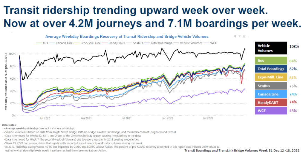
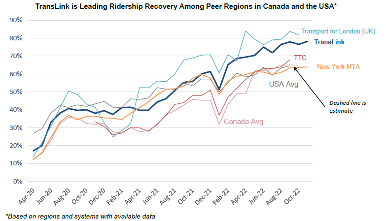
Another busy week, this one featured a TransLink Mayor’s Council meeting, our third meeting of the term, but the first in-person meeting since inauguration. There was some good discussion, I thought I would share a bit. The first part of the meeting was a discussion of ridership returns, and how TransLink has adjusted the system through the slow recovery from COVID. There is good and news just OK news, but lots of reasons to be optimistic.
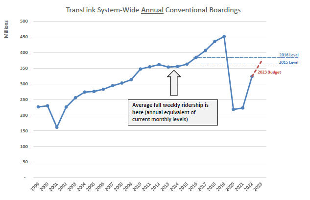
The just OK news is the headline that ridership is back up to 194 Million Annual journeys, which is about 82% of the pre-COVID peak, with bus journeys leading the comeback and West Coast Express lagging behind.
The good news is buried in the details. This recovery rate is by far the leader in North America, though we lag a bit behind most European systems. TransLink ridership in raw numbers is 5th highest of any metro region in North America, though we are the 24th largest service area by population. We have 60% more ridings than Seattle and Portland (our nearest cohorts in weather, demography, and size) combined. Metro Vancouver has more daily transit riders than the City of Chicago, which has three times our population.
Here in new west, our ridership recovery lags a bit behind the average at 77%, but we are still, at 28,000 journeys a day, one of the most transit-oriented neighbourhoods in the region.
A more interesting way to look at ridership is to put it in the context of the rapid ridership growth of the last decade. We are, essentially, back at 2014 ridership levels. In a sense, the current ridership levels harken back to the brief period post-olympics before we entered into that period of unsustainable crowding in the system. We are just starting to get to the point where crowding is starting to appear on some routes, tempered a bit by the noticeable change in travel patterns. Though we still have morning and afternoon “rush”, there is a lot more travel on weekends and offpeak times – reflecting reduced return-to-office ridership, and more service and recreational ridership.
One interesting aspect of this is the impact on monthly passes. Totally anecdotally (and indulging in my own bit of elite projection here) I hung up my compass wristband (which I used as a monthly pass) when COVID happened, and shifted to loading my compass card up and paying per ride. Clearly I was not alone here. This feeds into the discussion of revenue drivers for Translink, as farebox recovery has not been as fast as ridership recovery.
Which brings us to the financial situation. But I digress.
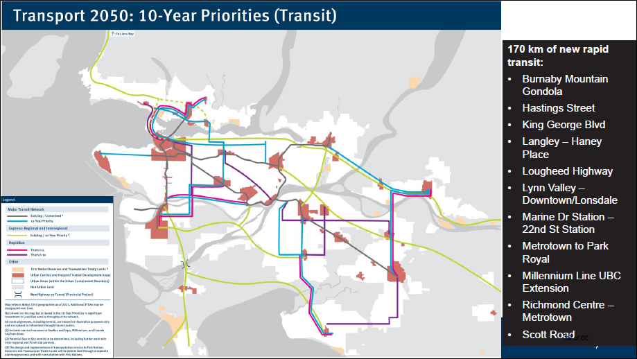
We then talked about the Ten Year Priorities for regional transportation. There has been much written about it, but this meeting Staff are seeking the Council’s endorsement of the plan which leans heavily on Rapid Bus (think 99 B-Lines in more locations) and BRT (which is something else entirely – but we will get deeper into that). They received it and endorsed it, unanimously, which is no mean feat around the Mayor’s Council table. We call come from different political backgrounds, 21 communities with different needs and priorities, but on this we speak as a united voice.
Two points of discussion raised in this plan, first related to the funding, second to the very idea of BRT.
This plan is not funded. It is natural that we need a unified and clear plan before we can seek the funding to achieve it, but endorsing the plan is not the end of the journey, only a rest point. We have work at the Federal and Provincial level, and in our own backyards, to secure a clear and predictable funding model to make this plan come to life. I am confident we will do it, as this plan is fundamental not just to the transportation plans of the region, but to the transportation, livability, affordability, and climate plans of the Province and the Country. As PoCo Mayor and Mayors Council Chair Brad West put forward at the meeting, this plan is not a “nice to have”, it is as necessary to the functioning of our region as our water, sewer, and electrical utilities. And we need to remember that as we work through the details of a funding plan.
The other conversation we need to have is about Bus Rapid Transit (“BRT”). This is a form of rapid and reliable transit that is common in many jurisdictions, but pretty new in North America. It offers a functionality somewhere above a streetcar or B-line, not quite to the level of full grade-separated light rail, but in a sweet spot that fits our region very well, provides a lot of flexibility, and saves us a tonne of money over elevated rail.
The trade-off is that BRT can take space away from other traffic. Though way less intrusive than an elevated rail line, it still means either re-allocation of existing road space, or creation of new dedicated road space. It has the potential to be one of those new infrastructure directions that everyone wants near them, but not too near. It will be more apparent to drivers than a tunnel or overhead light rail line. There also needs to be careful interface planning between BRT routes and other road users, such as pedestrian crossings, bike lanes, and even areas where we want to see traffic calmed, like pedestrian-oriented commercial areas.
So we have some work to do, to educate the public about BRT, and to educate senior government about our need for consistent and reliable funding. The good news is that the plan is solid, and solidly supported by the leadership of the region.
Trying hard to get back to my post-election semi-promise to try to post here once a week; Alas it was an aspirational goal I will strive towards, but not there yet. Though it is a good time for a bit of an update not just on what I’ve been up to, but what New West Council has been up to. You may have noticed our meeting agendas have been a little light (excepting random Motions from Council, which are another issue altogether), and there is a good reason for this.
We have 4 new City Councillors, and I am new in my role. There has also been a lot of change in the City over the last couple of years as we pivoted quickly to a COVID response, and more recently and slowly pivoting away from that initial response – recognizing that everything has changed due to COVID while there are still community expectations that the work that was delayed by COVID must go on. Into this, we had seven people elected with wish lists of things they want to do, even with promises of what they were going to do. We are going to need to figure out what to prioritize, or nothing will get done. That prioritization and strategic planning can only occur (in my mind), if all 7 members have a clear, and as equal as possible, understanding of the landscape between where we are and where we want to go. So all that so say: we have been doing a *lot* of Onboard Training. This emphasis is meant to assure the new Council members are up to speed enough to make informed decisions before we make any major changes.
We have had a number of Onboarding Meetings, basically every Monday and Wednesday since early November, a few hours at a time. Different departments present to Council on what they do – their current work plans, the things they are looking at for longer-term planning, their pressures and challenges and the opportunities they see in the short term and in the years ahead. Council was able to have some frank discussions with them about our ideas and concerns. If you want to watch one of these meetings, they are streamed live, and you can watch them here. For example, click on January 23rd on the calendar, and you can watch our discussion of the Anvil Centre, Building and Planning Permits and Fees, and Pay Parking policies. Yep, there is minutiae.
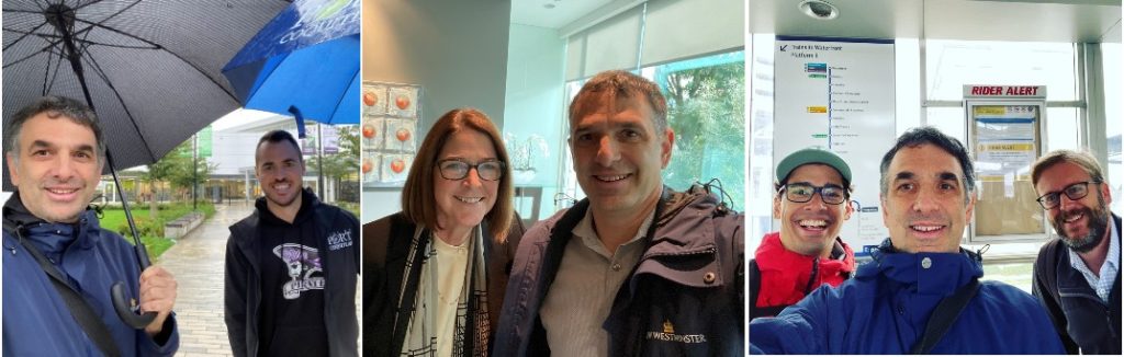
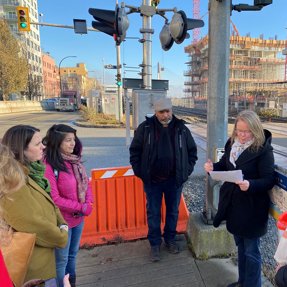
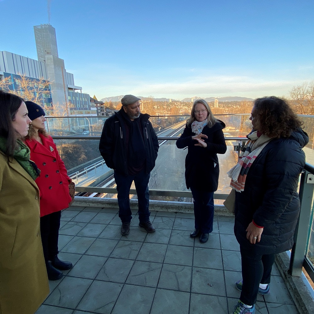
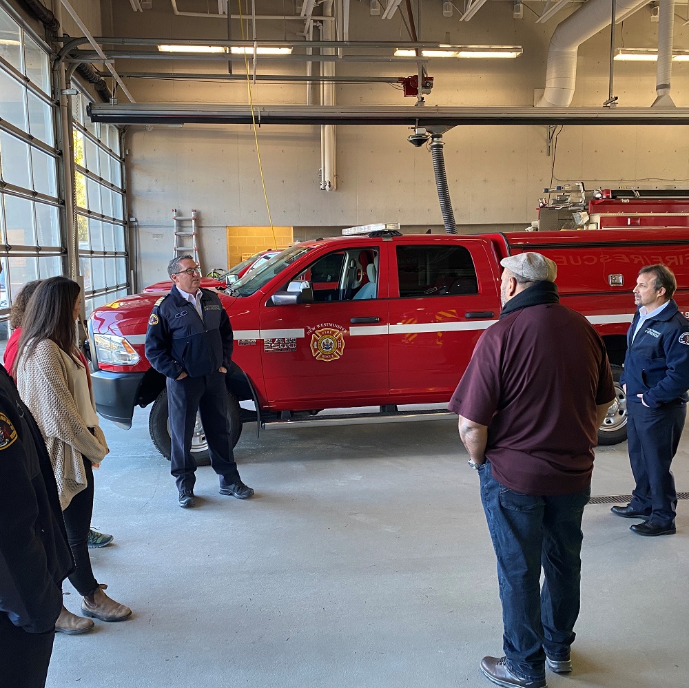
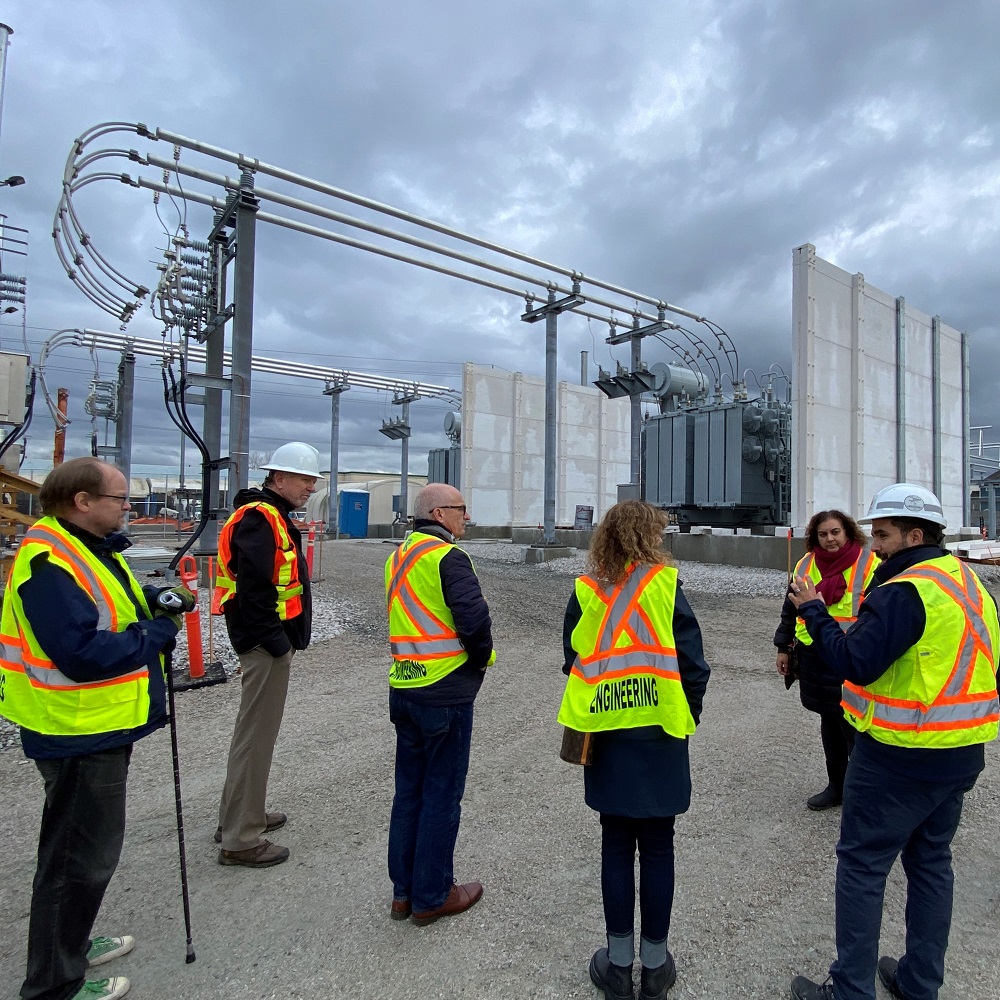
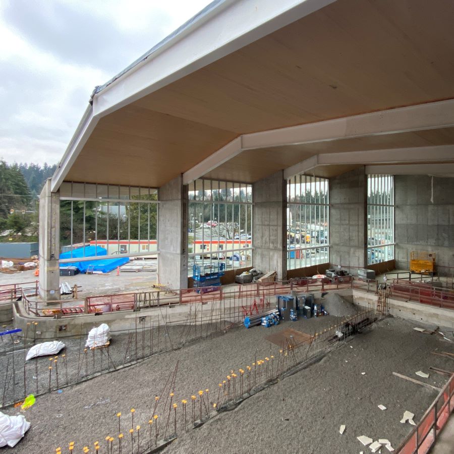
We have also had a few tours of City facilities and sites of interest in the City. Talking about whistle cessation or works yard space issues or the new təməsew̓txʷ Aquatic and Community Centre in the abstract is not as useful as going to the sites to look over the site so Council and Staff can actually point at the things we are discussing. Down at the bottom, Ill add some photos from our tours, and note these are going to continue for another couple of weeks as we build towards Strategic Planning in early February.
I have also been taking the opportunity as Mayor to meet with Staff where they work. Not the senior staff we see often in City Hall so much as the 1,000-odd folks who keep the City running day to day. It has been great to chat with them about what they do every day, and what their pressures and concerns are, in an informal way. These meetings are ongoing as well, as I have a few more sites to get to.
I’ve really appreciated the time regional leaders (new and experienced) have taken to meet and talk about our shared challenges and opportunities.
Meanwhile, I have had a chance to meet with many of my regional colleagues, some in person, some through phone calls or zoom. And I’ve had meetings with our local MLAs, and phone meetings with the new Premier, and several members of his new Caucus.
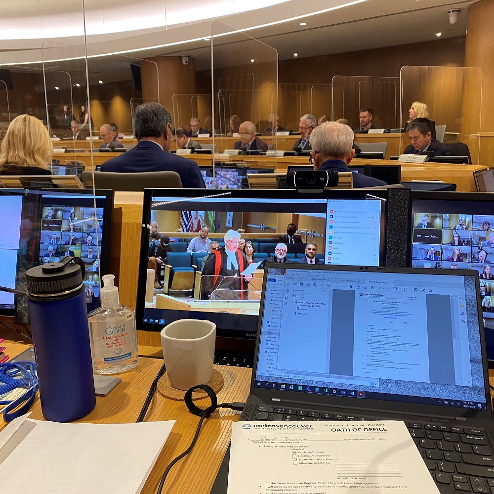
Then there is the onboarding I have been doing at Metro Vancouver and TransLink. The Chair of Metro Vancouver appoints regional leaders to various Committees, and I am on several, including Parks (we had our Inaugural meeting January 11), Climate Action (I chaired our inaugural meeting on January 13th), Liquid Waste (Inaugural meeting January 18th), and the Board (next Meeting January 27th), along with the Indigenous Relations Committee (Which doesn’t meet until February). The TransLink Mayor’s Council has had several onboarding meetings, and has another meeting January 26th, and I have been named to the Finance Committee, so that will be another monthly meeting. It’s a lot of meetings, and a *lot* of onboarding. So as I empathize with my new Council colleagues drinking from the firehose of info, I am feeling it myself at the regional level.
Metro Vancouver Board meetings are a bit complex, with 40 Board Members, a challenging meeting space, and a plethora of screens. Here was a part of my view during the Inaugural meeting.
The good news is that staff in both organizations have been great in getting us elected types the material we need so we can read ahead and be prepared for training, and Council has been working hard and asking lots of questions. This is time and energy well spent, as it will make us a stronger group of leaders for the community.
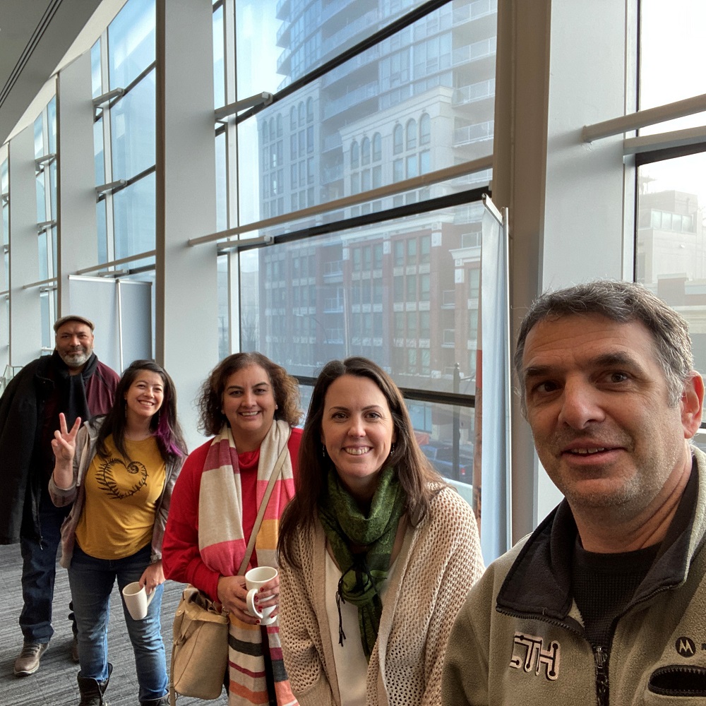
Now for the photo tour of some of our tour stops (so far):
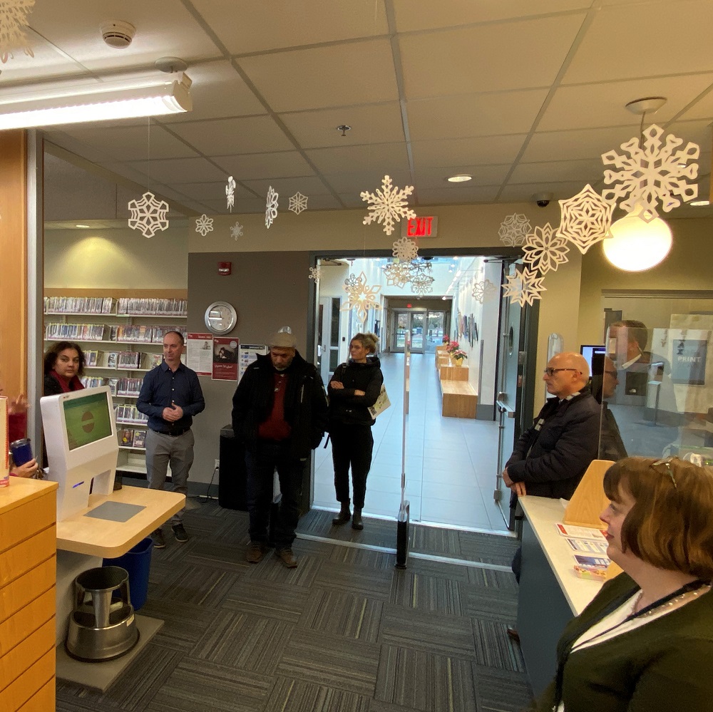
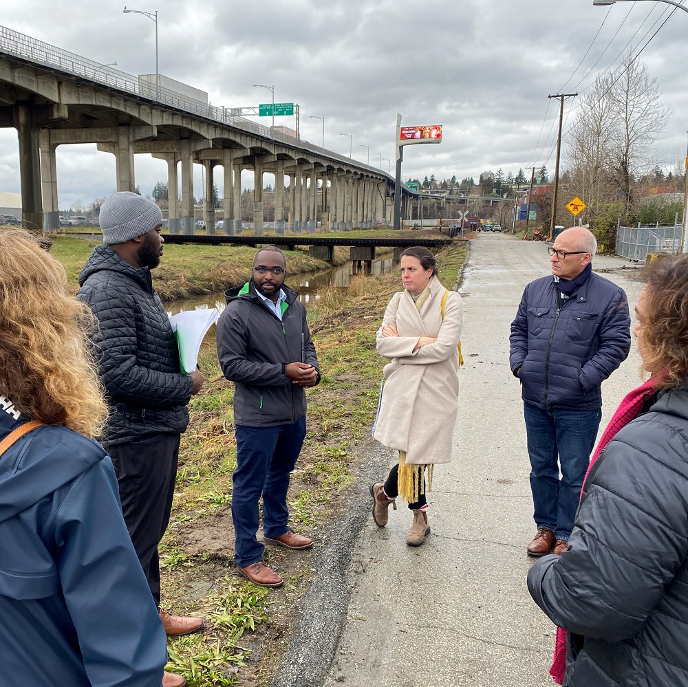
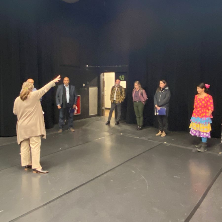
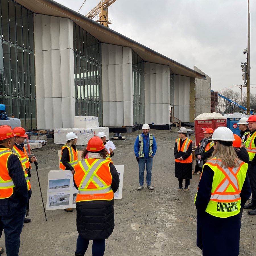
We toured the Anvil Centre to see the behind the scenes parts of the Archives and museum collection, the performance and conference space.The topic of train whistle cessation is one where the new Councillors especially benefitted from seeing the on-site challenges and the work staff has done to make it work downtown……while also recognizing the special challenges at Sapperton that mean it is still a work in progress.We’ve now visited all three Firehalls – the good, the almost-as-good, and the ugly. Each has its own character and use, but one really needs to be replaced.The new substation in Queensborough represents the single biggest investment we have ever made in the sustainability of our electrical grid. It is almost ready to get turned on, and is looking to come in a little under budget – no mean feat in this time of inflation and supply chain disruption.Visiting the Queensborough Community Centre was highlighted by seeing how the satellite library branch meets the needs of that community through careful collection management and programs.We had a long discussion with engineering staff about Queensborough drainage infrastructure, the importance of the pump system and open watercourses, how the system is maintained, and some of the engineering challenges that come with ongoing upgrades to the system.We toured the refreshed and renewing Massey Theatre to see how the MTS is making this into a new hub for teaching, experiencing, and engaging in the Arts.And finally, today we got to tour the təməsew̓txʷ Aquatic and Community Centre, and I think most of Council was left agape at the scale of the project, as most of the framing is complete (except over the 50m lap pool). This is going to be a real game-changer for community space in New West come 2024.
It is 2022, which means 2021 Census data is trickling out. If you are interested in this kind of data, you should probably be over at censusmapper or Mountain Doodles where Jens does cool things with maps and data visualization to make census numbers fun. But before you go, I want to talk a bit more about what the census can tell us about the regional housing situation.
I have written a few blog posts in the past that compare census data to the regional growth trends projects in the Regional Growth Strategy – the master document of regional planning for Metro Vancouver, and the one that all municipal Official Community Plans must align with. In those posts I compared the decade of population growth that the regional government planning folks predicted back in 2011 to the actual population growth shown in the census. Turns out (surprise!) growth is not evenly distributed around the region, and though the overall growth of the region is close to the projection (when you account for census undercount, which is an interesting phenomenon), but there are great regional variations between those communities that met or exceeded their regional growth projections and those that fell far short.
However, the population count is not something cities directly control (despite some fanciful promises candidates may offer). The region grows for many overlapping demographic, economic and socio-political reasons, and cities can either accommodate that growth (by supplying homes, employment spaces, utilities, infrastructure) or choose not to (and face housing price inflation, labour shortages, and failing services). The Regional Growth Strategy also includes projected dwelling counts for every community, and Cities though their policies and practices, have much closer control of this. It also happens that dwelling count is a major factor in housing affordability – the idea that increasing supply puts downward pressure on price is not controversial outside of some Landscape Architecture schools.
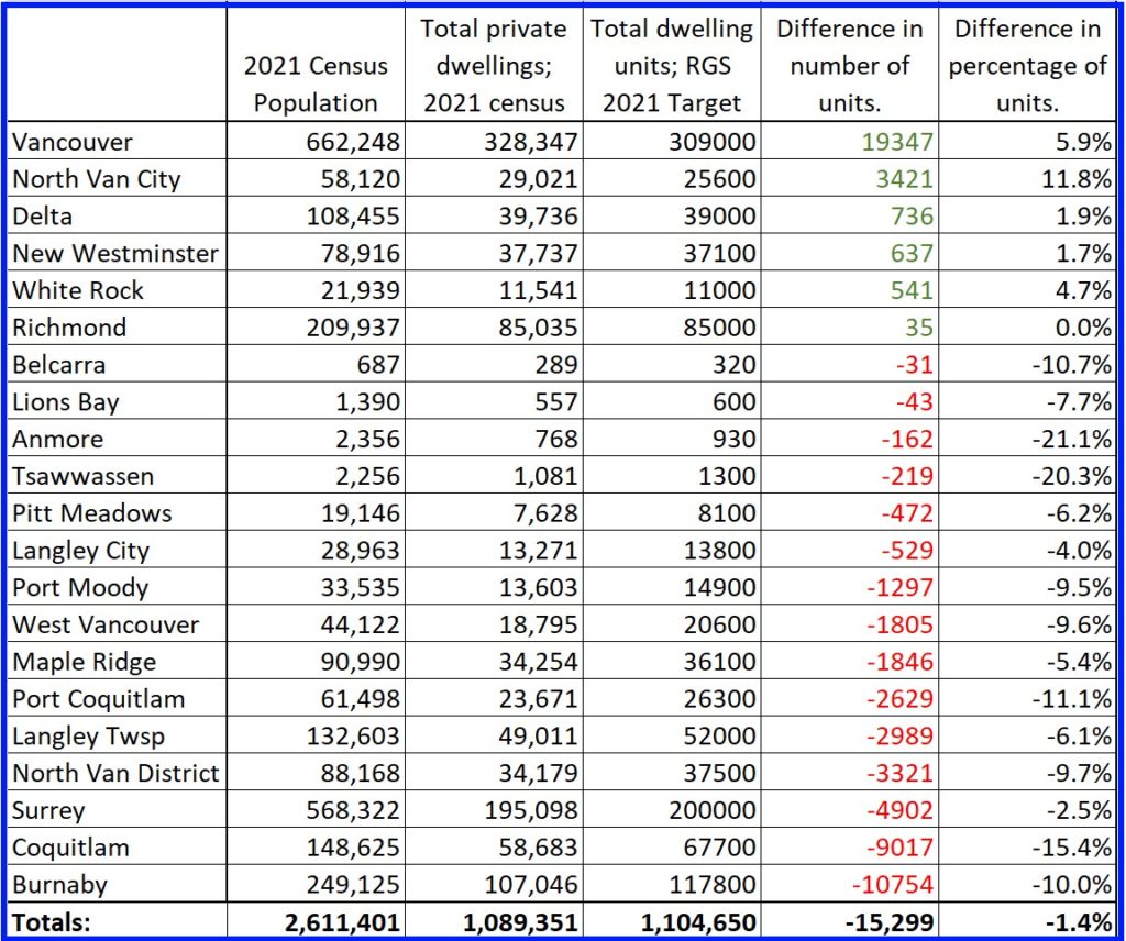
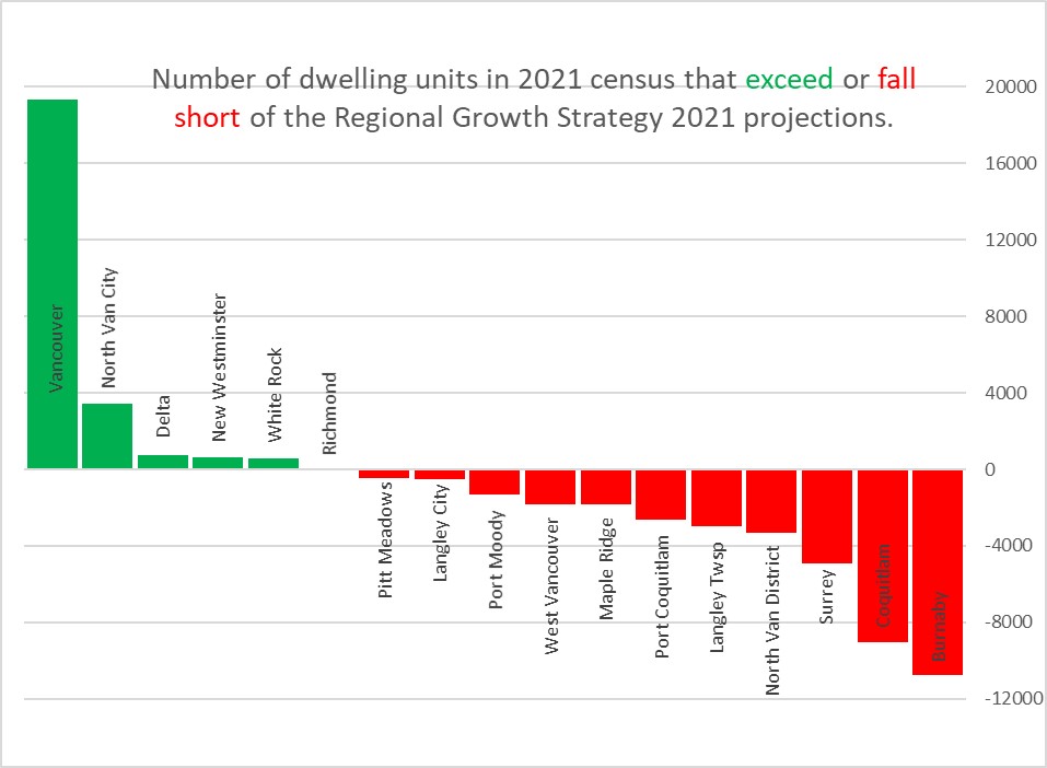
The 2021 dwelling count data was recently released by Statistics Canada, and we can now compare the decade-old RGS projected numbers for 2021 to the census numbers for 2021. I’ll start with a table, because I am not the data visualization genius Jens is:
I don’t think anyone would be surprised to see only 5 of 21 municipalities built more housing units than the RGS projected, though some may be surprised to see Vancouver exceed its targets by almost 20,000 units. As is probably expected, North Van City exceeded growth projections by the highest amount proportional to its population, and Delta, New West and White Rock round out the Municipalities that built more housing units that projected (and Richmond was within statistical error of it target). However, during a decade of overlapping housing crises, while everyone agrees the affordability of housing is the primary local government issue, every other Municipality in the Metro Vancouver fell short of the very commitment they made to the region to get new housing built.
Yes, I dropped Anmore and Lions Bay and other small munis that have negligible effect on regional housing supply.
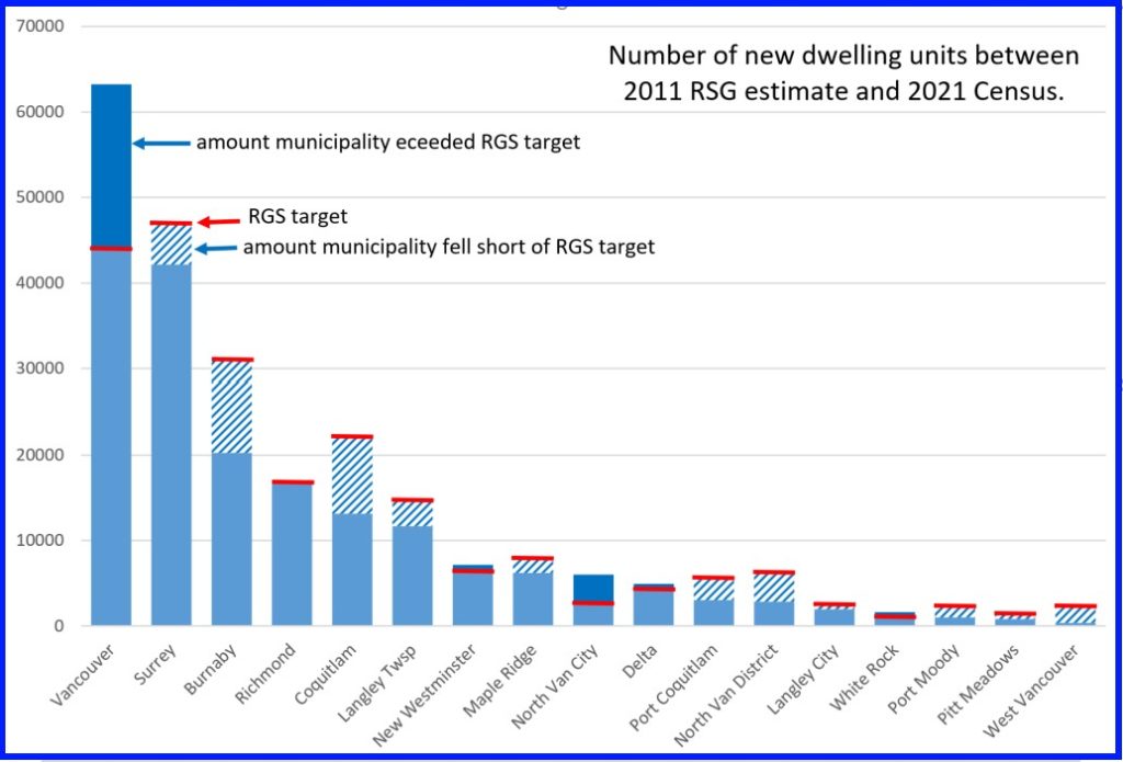
Of course, not all munis are equal in size, nor are all munis equal in their ability to accommodate growth. A significant part of the Regional Growth Strategy is to emphasize new growth near transit and established transportation networks, to increase residential density near work / study / shopping areas to reduce transportation burdens, and to prevent the erosion of the ALR and and the Urban Containment Boundary. This is why the RGS set different targets for different municipalities, and came up with 2021 targets that every muni could agree to when they signed off on the document.
So I compared the projected increase in dwelling units from 2011 to 2021 to the amount that each municipality exceeded or fell short of the 2021 target based on 2021 census data, and you can see how the growth was not only shared unequally, but how different municipalities had different commitments to the agreed-upon plan. It is here that the two recalcitrant North Shore districts and the Tri-Cities really stand out.
Note this is not total dwelling units, just the increase between 2011 and 2021. It also shows that the apparently-rapid growth of new towers in Burnaby and Coquitlam are not enough to keep up with the demand that was projected in the region a decade ago. And that Sea Bus apparently is the great catalyst to urban growth?
The RGS is being updated right now, the decade-old document projecting to 2040 is being replaced with one projecting to 2050. All of the Municipalities are expected to sign off on it, though there are some rumblings Surrey is going to push back because they felt the other cities were not sufficiently diffident in granting them a major re-draw of the Urban Containment Boundary so they can replace forest with warehouses. One of the concerns raised by New Westminster through that process was that municipal projections/targets are being replaced with sub-regional ones that clump municipalities together, further reducing the accountability local governments have in addressing our serious housing crisis. And with strong anti-growth voices rising regionally during this local government election period, I am less confident that the order of government most able to bring in new supply is going to get the work done.
If I wanted to add a second floor to my house where there is currently only an attic, what bylaws/restrictions/regulations/etc do I need to know about? Where is that information available?
This is one of those questions you probably shouldn’t ask a City Councillor, as there are better people to ask. Our work is to provide executive oversight of the City as a Corporation, and to set governance policy for the City as a Municipality. We approve changes to the Zoning Bylaw and make sure there is enough money to hire building inspectors, but the operational side of these things are managed by our professional staff. Though we interact with that every day, we are not (by sheer volume of the diverse things a City does) technical experts in every aspect of the City’s operations. But with that caveat, I’ll take a dive, because you asked.
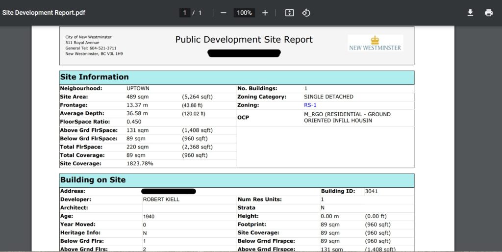
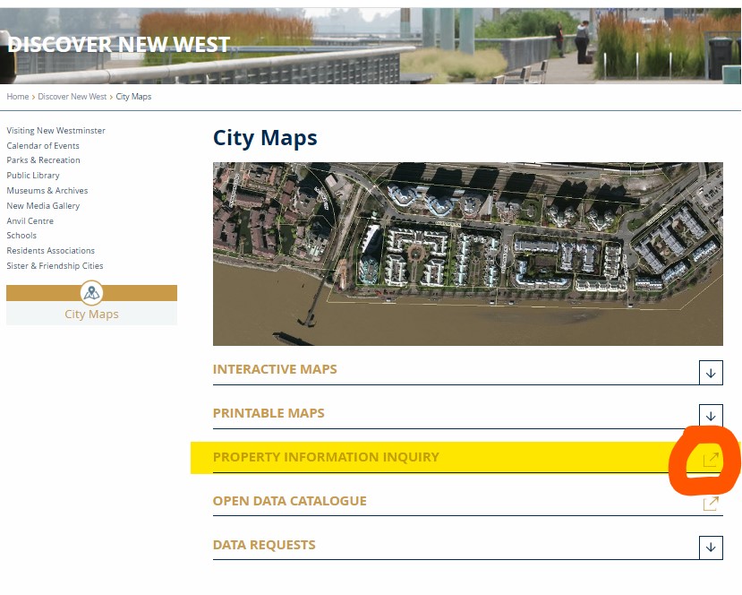
The first thing you want to do is look up whatever info the City has on your house, and you might be surprised how much of it is publicly available on the City’s website. For example, you can go to the Property Information Inquiry page here:…enter your address and get a quick report on your house. It looks a little like this (note some redacted stuff because for some reason, it is de rigueur for folks to redact publicly available information like this to make it look like we are protecting our privacy):
From this you can learn some things, like your zoning designation (in this case, RS-1), your lot size (489 sq m), your floor space (220 sq m) and subsequently, your FSR (0.45). You can also determine whether that basement suite you have is legally registered (in this case it is, but it is not listed as a secondary living unit, meaning it is not being rented out), if that old shed out back is considered a “building” by the City (in this case, there is no secondary building on the site), or if there is specific Heritage Protection on your house (in this case, no).
You can also go to the City’s on-line Interactive Map called CityViews to do much the same by selecting “Run a report” on any property you select:
And you get some more info about the development of the property, including old building or development permits that may apply:
This is all interesting stuff, but how do you apply it? The thing for you to zoom into is your zoning entitlement. In other words, what does the zoning for your property say you are allowed to build as it currently stands, and how does that compare to what you have now? It really doesn’t matter if you are planning to renovate your existing house or build a new one, if you keep your plans within the zoning entitlement, your life is much easier.
In the case of the above house, the zoning is RS-1. To know what that means, you look at the zoning Bylaw which is available here. The RS-1 zoning Bylaw describes what you can do and build, but it is 7 pages long, and a bit complicated to read for someone new to this. For example, it is called Single Detached Residential, but you are typically allowed to have up to three living units on an RS-1 zoned property – A main house with a legal secondary suite and a laneway/carriage house – as long as they meet various size and design criteria.
One big criteria is FSR – the ratio of living space over the size of your lot. In the example above, the house has 220 sq m of living space on a 489 sq m lot, so 220/489 = FSR 0.45. In RS-1 zones you are allowed an FSR of 0.5. Except you can increase this if you build a more energy efficient building (up to 0.55 for Passive House standard). This is assuming you can do so and meet the other criteria in zoning, like a maximum height (25 feet), minimum yard setbacks (distances between the building and the lot lines) and not exceed the maximum site coverage (35%). These numbers are all different for every zoning type, not all SFD in New West are RS-1.
So if you want to convert an attic to a living space, and if this attic space is not currently counted in your living floor space, turning it into living space may increase your FSR. If you already have 0.5 FSR, this may not be within your zoning entitlement. That is not to say you cannot do it – variances are requested and granted all of the time, and they are based on an assessment of the “reasonableness” of the variance. Yep, that sounds subjective, but it does relate to a bunch of policy the City already has in place, and you really need to sit down with a planner at the front desk at City Hall to find out what your options are. You can even set up an appointment to ask a planner this stuff. Don’t tell them I sent you, and as a tip, don’t say “Councillor Johnstone told me I can…”, because that is not something they want to hear. They don’t work for me, they work for the City, and are guided by policy and bylaws created by Council, not the whims of single council members.
All I’ve talked about up to here is zoning. There is also a bunch of Building Code stuff you may have to deal with, from assuring safe fire egress to assuring your site is prepped for sewer separation if your renovation exceeds a certain value. I can’t even get into that, except to say that the BC Building Code is enforced by the City, but not written by it. If it looks like staff are putting barriers in place to you getting the job done, they are more likely just pointing out the barriers that exist so you don’t trip over them. Neither you, your mortgage holder, your insurance company, or your neighbours wants you to be building something outside of building code.
If I was to give quick advice, it would be to hire a local Architect or Designer to guide you through this if the first chat with City Staff makes it look like your plan is viable. And architect’s job is to translate what you want (more square footage? a third bedroom? a brighter space?) into a set of plans that are compliant with the building code and the City’s zoning bylaws, or to help guide you through the process of seeking variances from either of those if needed or appropriate. They don’t just draw pretty pictures of buildings, they design functional and legally-conforming spaces, work with engineers and contractors to make sure they get built right, and act as liaison to the City to help interpret a pretty complicated set of zoning and building codes. They are worth the money for a project like this, and their advice is way more useful than that of a random City Councilor and his blog.
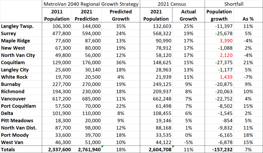
The 2021 census data is starting to trickle out. The first release of data is on population and housing, which is obviously a hot topic in the Lower Mainland. This means there are a lot of news stories about what has changed since last census in 2016. However, because of the work I do, I prefer to look at the change over the full decade since 2011. This is because 2011 was the “baseline” population level that the 2040 Regional Growth Strategy for Greater Vancouver is pegged. Since every municipal Official Community Plan was developed in context of the 2040 RGA, and since we are currently updating to a new 2050 RGS, I thought it would be good to re-look at Greater Vancouver population change in comparison to the RGS with the new census data.
Regular readers (Hi Mom!) might remember me doing something like this last year with the 2020 Stats Can population estimates. As it turns out, actual counts are more accurate than estimates*EDIT – see below*, and an update is required. Here is the table of Municipalities with 2021 Census population sorted by the rate of growth since the 2011 Population used for the Regional Growth Strategy (yes, I excluded the minor Municipalities like Anmore and Electoral Area A, for simplicity, laziness, and because I can).
Where to start? Overall, the region (excepting those small Munis ignored above) grew by an overall 11% over that decade, falling far short of the predicted growth of 18%. This means there are at least 157,000 fewer people living the in Greater Vancouver than expected. Only three Municipalities added more population than the RGS expected: Maple Ridge, the City of North Vancouver and White Rock. That last one might be a surprise, but remember White Rock had the lowest predicted growth over the decade, and so their growth being on par with the regional average put it way above what was expected.
Note that North Vancouver District and Port Moody have essentially not changed in population over the last decade (though found two very different political pathways to this lack of change) and West Vancouver lost population. The overall result is that every region of greater Vancouver fell short of the predictions, excepting the Northeast corner of the regional district.
The story locally is that New West also surprisingly fell short of the RGS goals, though only by a small amount. Nonetheless our 17% growth rate was one of the fastest rates in the region. This is perhaps more remarkable when you note the only Municipalities growing at a faster rate happen to be the 3 easternmost ones – those with the greatest access to greenfield into which to sprawl.
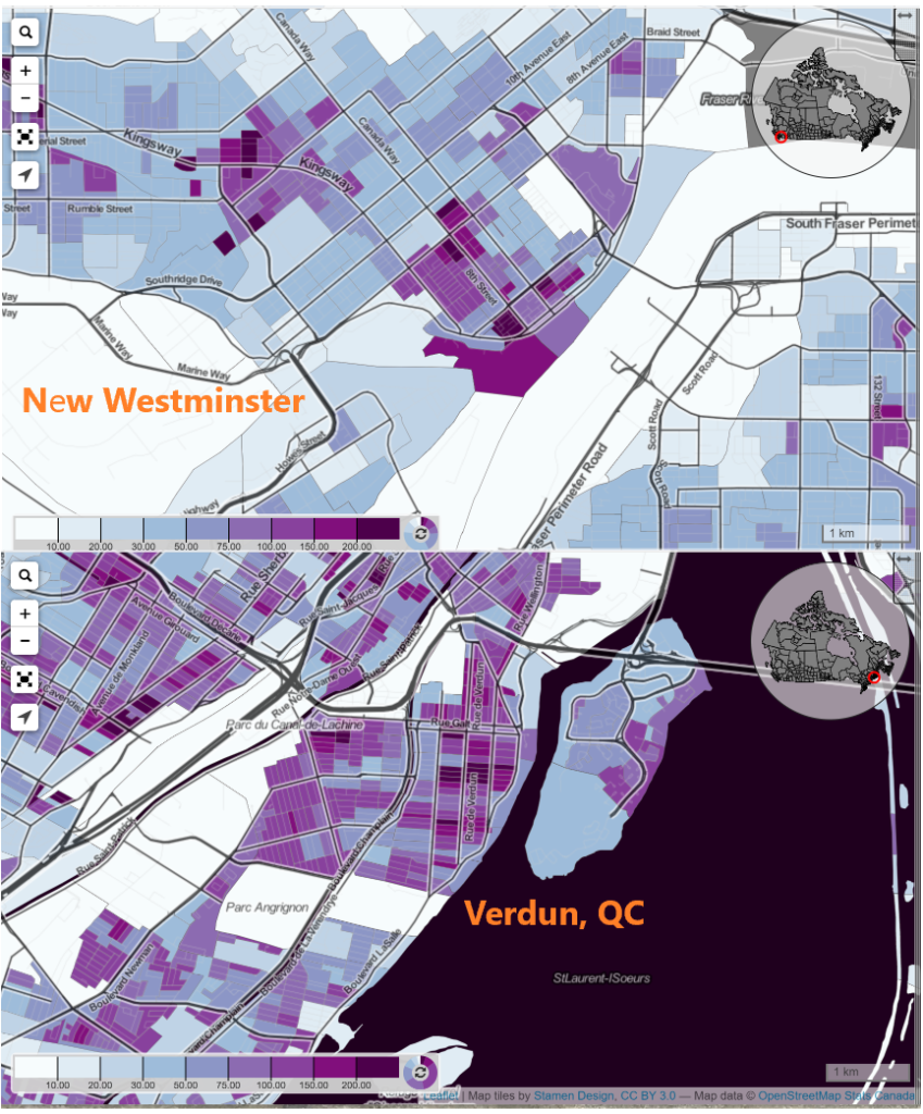
Which bring us to the other New Westminster headline of this census release: New Westminster being touted as the major municipality with the second highest density in Canada. This is interesting, but I may argue this is a bit of an artifact of the data and political jurisdictions.
We are surely a dense urban community, which is a natural result of being the nucleus of a rapidly growing urban area for more than 150 years. Our footprint is compact (under 16 square kilometers) and we don’t have farms or large undeveloped areas of forest, having chopped most of those down about 150 years ago. Our urban form was mostly established before the automobile era, and was not extensively re-drawn with Motordom.
However, this does not make us that different from many older urban areas of Canada. But in looking at the data, we need to remember that satellite centres of Toronto or Montreal are amalgamated into one larger municipality. Shown at the same scale using Censusmapper.ca and population density data, it doesn’t immediately appear that New West (as a 79K population commuter suburb of Vancouver) is much denser than, say, the arguably comparable (population 72K commuter suburb of Montreal) neighbourhood of Verdun.
I’m not ready yet to say what it all means, as there is more data and mapping to come out. However, New Westminster is part of a region facing a long-standing housing availability crisis, and more acute housing affordability crisis. We may be bringing on supply as fast as anyone in the region (and faster than most) but at 79,000 people, we are still only 3% of the region’s population, and addressing the supply crunch is going to take more than New West can do alone. We need more action across the region.
At the same time, I am proud to say that New West is bringing in not just supply, but a diverse type of supply. Market condos are meeting the region’s most aggressive Family Friendly Housing policies. We are approving more Purpose Built Rental than we have in decades, and we have truly affordable housing options being built across the City as fast as the funding for these units becomes available. Though the value of land has shifted regionally past where rowhomes and townhouses represent “affordability” for most families, we are starting to see a big uptake on this type of build in traditionally Single Family parts of the City, and this long-standing gap in supply is finally being filled. We are also bringing this supply on while protecting the more affordable housing in the City, for the most part avoiding the mass displacement of people from existing lower-cost housing through strong policy. We have a lot of work to do, but we are on the right track.
*EDIT *: TIL: I’m completely wrong on this point. Census population estimates may actually be a more accurate count of the number of residents living in a municipality, because they account for the way the census systematically undercounts. Read more here, if you care. Fascinating!
I finally had a little time to condense down a bunch of thoughts and notes about the Opening Doors report that was delivered to the Provincial Government last year. I read the report when it came out last summer, and noted how it landed in an overstuffed news cycle to be almost ignored by anyone who wasn’t already a housing wonk. I might have winged a bit on line at the time, but I was not overall as critical as some of my neighbours across Tenth Ave.
Last month we held a Workshop at New West Council to talk through the report recommendations with staff support, and prepare a more formal response to the provincial government (you can watch a video of that meeting here and see the report and presentation City Staff prepared to inform that workshop here). This brings me to my regular warning that the comments that follow are mine, not the official position of New Westminster City Council or anyone else, and you might want to watch that video to see some of the more nuanced discussion other Councilors brought to the discussion.
The report needs to be put into the context of how and why it was created. It was an Expert Panel put together to provide advice to the BC and Federal Governments (delivered to the respective Ministers of Finance, notably) so it weighs heavily on things senior government can do. The Experts on the Expert Panel were, perhaps shockingly, bereft of municipal experience, and their decided expertise in finance and property development resulted in their firm application of Maslow’s Hammer. I also chagrin that the progressive *economic* quick wins proposed were the only part of the report that the senior government Ministers of Finance rushed to make comment on – and that was just to say no to them at the moment they were proposed.
But I’m already getting ahead of myself. Let’s look through the major policy directions proposed, from the municipal perspective. There were 5 major themes, and 23 recommendations, and you can read through them all if you like, but much like the conversation we had at the Council workshop, I’m going to summarize by order of government, because we all have work to do to address what is a national crisis at this point.
Things the Feds can do:
The roots of our current homelessness crisis are found in the early 1990s when Paul Martin looked at the comparatively modest housing cuts under a decade of Mulroney, and decided he could do better. The 1994 Martin budget got the federal government right out of the business of building housing. When a rapidly growing and urbanizing country like Canada goes from building 15,000-20,000 social housing units a year to less than 1,000 there are going to be devastating effects. And here we are.
So, with the Feds having the, by far, deepest pockets, it is not surprising that the one thing the Feds could do first is start using those funds to build housing. To quote directly:
the federal government make long-term funding commitments, as was done until the mid-1990s, rather than offering short-term capital grants. We recommend that the scale of these funding commitments reflects what is required for the construction of new social housing units to return to historic levels, when nearly 10% of all national housing starts were social housing units
There are also great recommendations here about making Federal Lands available for housing in high-demand communities, giving the non-profit housing sector more tax incentives, harmonizing programs that may speed housing being brought on-line (like federal/provincial/municipal building codes, fire codes, energy efficiency codes, etc.). But, still, someone has to pay for the housing that the market is not going to provide.
There is also a recommendation around incentives that stands out to me:
federal and provincial governments create a municipal housing incentive program rewarding the creation of net new housing supply wherever demand occurs… their primary purpose is to recognize municipal costs incurred in growing the housing stock and reward growth of housing supply where it is needed.
This addresses straight-on a significant downloading concern all Cities have in investing in affordable housing. Given an historic lack in Federal and Provincial funding (only beginning to be abated now), creative cities looking to be proactive have tried to leverage local powers to get housing funded. This means directly spending on housing, giving our limited land base up to affordable housing projects, or leveraging affordable housing as a community amenity attached to new market housing. This last one definitely has populist appeal, because it makes people feel we are making the “greedy developers” pay for it, but the reality is we are simply taking money that would have otherwise been used to pay for other community amenities – parks and recreation centers and libraries – and as we dip into those resources, we lose public support for growth, because we cannot provide amenities that assure a denser City is livable and full-service.
So this recommendation seems to suggest that Cities that meet housing growth targets are prioritized for federal funding. I actually hoped it would go a little further and suggest that federal infrastructure granting programs like ICIP should specifically hinge on high-demand communities like New Westminster meeting their housing targets.
Things the Province can do:
When Martin/Chretien gutted federal funding for housing in the early 1990’s, BC stayed in the business of building housing for another decade or so, until the Liberal Government of Gordon Campbell put an end to that in 2002. Though programs are now coming back in a meaningful way, we are left with a big gap of 20 years of underbuilding to our needs.
All of the points above about what the Feds can do also apply to the Province – they can provide funds, land, and incentives. Though their pool of funds is somewhat smaller, they are in the right place to note and be proactive about regional needs, and indeed the money saved by giving people safe, secure homes comes right back to the Province through savings in health care and other social support spending.
One aspect of this that is somewhat missed in the panel report is the opportunity for the Province to get back into the business of supportive housing. By the current model, the Province may provide funding to private developers to include affordable housing in their market housing proposals and/or provide funding for the not-for-profit sector to deliver and operate the housing. This is based on the neoliberal idea that government saves money by paying someone else to do something instead of doing it themselves. This is the model that brought us disastrous results when a pandemic hit the care home sector, and a model we still somewhat resist for healthcare. But this is still an operating assumption for housing that adds complication and uncertainty to the delivery of housing, and makes it harder to get housing built.
This report skates around the demand side of the equation. I know this is a politically charged discussion in a growing country with ambitious population and economic growth models, and I am not going to delve into the fanciful economics of a certain UBC landscape architect or the xenophobic ravings of familiar populists. Instead, I would suggest the place where demand management comes in is the federal and provincial taxation structures that reward the commodification of housing, while at the same time providing no benefit to renters or those who are unhoused. For whatever reasons these various structures (homeowner tax credits, capital gains exemptions for housing, etc.) were developed years and decades ago to encourage people to buy and stay in houses, they no doubt provide a perverse incentive during a housing crisis where most cannot afford the ticket to entry while taking hundreds of millions of dollars out of the government’s coffers that could be better applied to providing housing to those in need. This is the part of the Expert Panel Report that senior governments rushed to say they were not going to enact. See recommendations 21 and 23:
21.…make changes to tax programs to bring the treatment of renters and homeowners into closer alignment. This would include reviewing the impact of the capital gains tax exemption on principal residences… and extending comparable support to other forms of wealth building; 23. …phase out the Home Owner Grant. Monies saved from this should be used to fund social housing in addition to the commitments made in the 10-year plan.
Alas, the Culture of Contentment assures that no government, no matter how progressive their campaign, will be willing to address this disparity any time soon.
Another important piece missing from this report is the need to protect renters and keep people from becoming homeless in the first place. Again, the Province has made tentative steps in the right direction here, but is not where the City of New Westminster and other local governments have been asking them to be in stopping renovictions and demovictions.
Things for Local Gov’t to do?
I’m going to mix together our Regional and Local government parts here, and only note that the Expert Panel Report skips regional government altogether, though they are a significant provider of affordable housing in the Lower Mainland and other regions of the province. They are also the level of government that sets regional land use and housing policy, but we’ll get to that.
The part to remember is that this is a report to senior governments, and the question here is more “what can senior governments to do to either compel or make local governments approve more housing faster?”. This might sounds strange to many in New West, where we are meeting (and slightly exceeding) our regional growth strategy targets for housing, rental and affordable housing, and population growth. If anything, I feel people are starting to feel a bit of growth fatigue related to construction impacts. However, we are one of the few municipalities hitting these targets (as I talked about at length here), and housing demand is still far outstripping availability – so what can the province do to get those other municipalities to keep up?
Right off the bat, we know the first recommendation doesn’t work:
the B.C. government impose statutory time limits to all stages of the property development process, municipal or other, for all types of development. Similar limits imposed in Ontario and Alberta can serve as examples
Putting an artificial timeline of, say 90 days on a Rezoning application as Ontario did, fixes nothing. The arbitrary nature of the limit belies the complexity of many rezonings, ignores that even the Province cannot commit to providing referrals within that time limit (in the case of EMA freeze-and-release provisions, or MOTI approval for development near highways as only two examples), effectively undermines the ability for an elected Council to do what the Community elects them to do. It reduces a local government’s ability to evaluate and benefit from land lift related to rezoning, and undermines any principle of meaningful community engagement over development. The net effect is that most rezoning applications would be turned down, not that most would get approved faster. It does this all while adding a new layer of bureaucracy – the tribunal through which applications not meeting timeline could be appealed.
Fortunately, more of the recommendations around introducing “affordability adjustments” to the Housing Needs Reports, aligning our OCP updates with these needs reports, provincial streamlining of development permitting processes province-wide and the such, are doable, reasonable, and would likely have wide-spread buy-in by municipalities, though they may take some work on behalf of all parties.
An identified theme is that Municipal and regional housing targets actually have to come with some force. We are dealing with a regional problem, and need to solve it regionally. There are a variety of sticks and carrots the Provincial Government can apply, and a lot of funding incentives for infrastructure to better support the pressures cities face as they densify. Indeed, changing how the province incentivizes growth would also result in significant greenhouse gas reductions and reductions in the cost of many different forms of service delivery. There is a big win in here, but it would require some political courage to step into what local governments (and regional governments) see as their turf. When half the mayors in the region are elected on straight-up or veiled promises to curb growth, political battles would no doubt ensue, but a crisis like this does not allow half of the region to say “not our problem” as has been the reality for a decade. They know who they are.
There are two aspects of how Cities approve housing that the Provincial government can definitely influence, as they are regulated at least in part but Provincial regulations: how Cities finance growth, and how our permitting programs work.
On the financing side, the report includes this recommendation:
conduct a full review of local government revenue sources and spending responsibilities… includ[ing] consideration of additional or enhanced funding sources for infrastructure and amenities that are more predictable and do not rely on rezoning or the development process. Preference should be given to means that capture land value through taxation, rather than homebuilding
To frame this a bit, Municipal governments collect Development Cost Charges (“DCCs”) on new growth, Voluntary/Community Amenity Contributions (“VACs” or “CACs”), and a whole raft of different fees and changes on development. It’s a bit of a complex mess, and outside of DCCs, not particularly well regulated. This creates not just cost, but uncertainty and complexity for builders and great variances across the province and region. One recommendation would be for the Province to clean some of this up. perhaps by expanding the DCC program to make it more flexible and reduce the reliance on VACs/CACs. This sounds easy, but is actually something that would have to be addressed with great care, as the balance between community and private benefit from growth (never mind the public perception of that balance) is precarious and dynamic, and Mencken warned us about seemingly simple fixes to dynamic human problems.
The second aspect of change could be in the permitting processes themselves. Given the financing issue is managed (see above),then strategic pre-zoning takes a lot of risk away from builders, and reduces the time taken to get from planning to occupancy. This type of strategic pre-zoning probably doesn’t want to occur until we have a funding model established to assure the community knows it is getting its share of the inevitable land lift (and Cities have a way to fund the parks, playgrounds, roads, theatres and libraries that make the community livable), and stricter and clearer design control is in place, as the City will functionally be ceding much of that control when it gives away zoning. There are incremental changes Cities can make in the short term (like New West, where we have given Development Permit authority to staff without an extra trip to Council), but some major shifts in the permitting process that are recommended (like reforming the problematic Public Hearing) would require changes to provincial legislation.
The summary
We have a housing affordability crisis because we are not building enough homes to meet demand. We have a homelessness crisis because we are not building enough non-market and supportive housing to provide appropriate shelter for people who are forced out of the bottom of the market as prices rise. These are two overlapping crises that require parallel approaches to fix.
The first problem is related to a complex mix of jurisdictional and political roadblocks, some easier to overcome than others, but even with the existing legislative framework and tax structure, municipalities can build to meet demand now. some of us are. If the Regional Growth Strategy is any guide, Municipalities like the City of North Vancouver and New West have shown that the solutions are available, but some municipalities simply don’t want to take part. We need to level that playing field.
The second problem is much easier to solve. Build housing for people who cannot afford to be in the market, like this country and this province did in the decades between WW2 and Mulroney/Chretien austerity, or as the Baby Boom generation calls them, the Good Old Days. Fortunately, this easier-to-solve problem can go first, and even the most reluctant local government can’t stop it if the senior governments are committed to fixing it. As a bonus, it takes the pressure off of the harder to solve supply/demand problem of market housing. But to solve that second problem, we first need senior governments to be more honest about the goals of our economic policies, while local governments need to be more honest about whether they actually want to solve the problem.
This report, for its strengths and weaknesses, could open doors to some of those more truthful conversations.
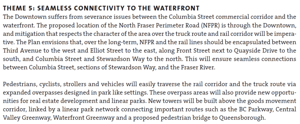
From researching the OCP and Downtown Community Plan it looks like Front Street generates a lot of noise pollution and significantly reduces the air quality for residents due to the freight trains and trucks that use it. There have been talks of eventually encapsulating the train tracks and Front Street and even the zoning bylaws or OCP states the buildings should be compatible with encapsulation. Toronto looks to be doing something similar and placing a park on top.
I realize that encapsulating tracks and Front Street will be very expensive and is likely decades away (Frankly I’m skeptical that it’ll happen in the next 25 years) Any idea what the City has in terms of timeline, vision and potential land use on top of the structure? If the idea is dead in the water/a pipe dream/no longer part of the City’s vision what are the City’s plans to address the safety, noise, and pollution in the downtown area?
Short answer is the idea is no longer part of the City’s vision for the waterfront.
Over many decades, there were various vague plans to build over the rail lines on the waterfront and/or Front Street. I’m not sure when this idea was first floated, but with the de-industrialization of the port and re-imagining of the entire downtown waterfront and Quayside starting in the 1980s, a lot of visions came and were either realized or went away when a new vision came along. Looking through old City planning documents from the last half of the Twentieth Century, you can see some of the encapsulation schemes that were sketched up. Some frankly fanciful.
It was never (to my knowledge) costed, and it was not clear who would pay the monumental cost. Its also not clear if the railways would agree to encapsulation or if the Ministry of Transportation would agree to a regional truck route that did not permit hazardous materials (because they are not allowed in tunnels). I don’t think anyone was concerned about what happened to the businesses and historic buildings that face Front Street. The vision seemed to rely on the entire waterfront, from the River Market to the Pattullo Bridge, being converted to residential towers, at least a dozen of them. These were pencil-sketch concepts, and I’m not sure there was ever a real understanding how to get there.
As recently as 2010, the conceptual idea was still bouncing around, as it worked its way into the Downtown Neighbourhood Plan – the planning document that serves as the Official Community Plan for the area below Royal Ave. When the new OCP was adopted in 2017, the Downtown Community Plan was included as an Appendix – as placeholder until a new Downtown Plan was developed. And it included this:
Since then, events have unfolded, and these became the proverbial best laid plans. I would suggest the one event that was more significant than any other was the demise of the North Fraser Perimeter Road (NFPR).
To understand the encapsulation idea, we need to understand the NFPR. There was a vision around the Turn of the Century (can you believe that phrase applies to 20 years ago!?) to shift more of the riverfront landscape of the Lower Mainland to “goods movement”. The so-called Gateway Program required the building of two limited-access high speed freeways, presumably to service trucks, but open to all traffic on either shore of the river. The South Fraser Perimeter Road was built, the NFPR was not. Primarily because of the horrifying impact on New Westminster.
The vision for the NFPR was 4 lanes, limited access, from a new expanded Brunette Interchange to the Queensborough Bridge connecting east and west to (not really clear). This may not sound so bad if the road is encapsulated from Elliot Street to Third Ave as suggested in the clip above (requiring, I note, the longest road tunnel in Canada), but what about east and west of there? There also existed the not-insignificant problem of pinch points like the historic Station building (Kelly O’Bryan’s) and interface with the SkyTrain guideway. Between the (federally regulated and not going anywhere) rail lines and other not-easy-to-move infrastructure, there simply wasn’t room for four lanes of traffic, buried or otherwise.
And there was the wider context of what it means to our community. If encapsulation addresses noise and fumes downtown, the NFPR only increases noise and fumes in Sapperton, in Fraserview, in the West End. And as more lanes always induce traffic, the knock-off traffic impacts on our surface roads would, if every other example in the history of building roads in cities has demonstrated anything, destroy the livability of many parts of the community within the noise-and-exhaust shed of the NFPR itself. Don’t get me talking about the Braess Paradox and Induced Demand.
The NFPR was a bad idea, and needed to be killed. It was killed in 2011 when TransLink proposed spending a couple of hundred million dollars on a key eastern connection to United Boulevard, and the community recognized it for the community-destroying freeway plan it was. I am really proud of the community who stood up to stop it, and the Council of the time (long before I was elected) that made it clear to senior governments that this was not on. We literally saved the City back in 2011, and TransLink went on to fund better things, like MOAR SKYTRAIN.
So without the NFPR, a different set of decisions had to be made. When it came time to invest in maintenance and upgrades to the Front Street Parkade, the lack of an NFPR meant we were able to right-size the structure by removing the older half of it, daylight some business fronts, and create a new public space. When the design for the Larco Parking Lot (now Pier West by Bosa) was being re-evaluated, we no longer wanted or needed an elevated podium cutting people off from the River, and were able to leverage another couple of acres of public park space for the Downtown. As we adopted whistle cessation downtown, as we design a new accessible pedestrian overpass to Pier Park, as we look at upgrades to the McInnis Overpass, as we plan greenway improvements along Stewardson, etc. etc., it is about planning for something that fits our community needs and connects our community better, not accommodating 4 lanes of high-speed truck traffic to slice our community in half, using an unbudgeted, difficult-to-realize, and half baked encapsulation idea to soften the blow.
The language in the Downtown Neighbourhood Plan has not been updated to reflect this change, but the planning we are doing around downtown certainly has. For the better.

 …enter your address and get a quick report on your house. It looks a little like this (note some redacted stuff because for some reason, it is de rigueur for folks to redact publicly available information like this to make it look like we are protecting our privacy):