Tunnels as problem solvers.

It’s inevitable, whenever discussion of traffic issues in New Westminster carry on for long enough, the topic of tunnels come up. Makes sense, as we are overloaded with traffic and there is no undeveloped space upon which we can build more lanes. So there is a portion of New Westminster population who figure tunnels are the solution to all of the City’s through-traffic woes.

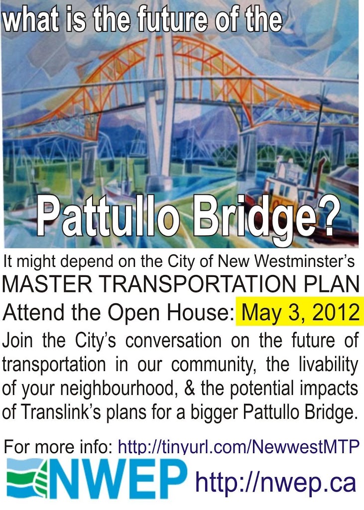
During the last Municipal Election, one mayoral candidate evoked the McBride Tunnel as the solution to the increased traffic that would be caused by expansion of the Pattullo Bridge. Captain Johansen told of a grander plan for tunneling the entire stretch of McBride to the legendary Stormont Connector. John Ashdown doubled-down on this idea by dreaming of a tunneled McBride, Stormont, and entrenched Royal Avenue.

There are two criticisms common to all of these plans: they will cost a fortune, and they don’t solve any actual problems.

Road tunnels in urban areas are notoriously expensive to build and connect to the existing road network, and what is being proposed would be the long road tunnels for Canada. McBride alone would be 2km, Stormont to the Gaglardi interchange another 2km. Add a trenched Royal Ave, and that’s 2 more kilometres. Each of these individually would be much longer than any existing road tunnel in Canada (the Massey Tunnel is just under 700m long, slightly shorter than the 730m Cassiar tunnel).

Length isn’t the only problem. Tunnels in urban areas have to deal with decades worth of utilities under urban roads: sewers (storm and sanitary), water and gas pipes, electrical and communication ducts. Varying fill materials, shoring foundations, contamination, archeology: it’s a mess down there. Moving all of those things out of the way to push a trenched road through is expensive and difficult. Not to mention the disruption at the surface during construction. For this reason, shallow cut-and-cover road tunnels are often no cheaper than deeper bored tunnels, which can avoid these entanglements. You can ask the folks in Boston about these complications and how they can result in runaway costs. Transportation Engineers I have talked to have estimated $4 Billion for a McBride Tunnel and surface Stormont connection. I cannot imagine anyone at any level of government coming up with that order of cash to solve New Westminster’s little traffic inconvenience.

Especially as these expensive tunnels are not likely to be an effective solution, but will only push the traffic pinch points a few hundred metres up the road to inconvenience another neighbourhood, or fill up our underground space with cars to go with our car-filled above-ground spaces. Anyone who thinks a bypass tunnel solves traffic problems has not spent enough time trying to drive through Seattle at rush hour.

If cost -recovery programs are included, then the tunnels will simply be avoided, as the Brisbane experience is showing. There, a tunnel under an urban area built to bypass traffic lights and allow “free flow” is failing: going bankrupt only two years after completion. As we have learned with the Golden Ears Bridge and will soon learn with the Port Mann, people will tolerate a lot of inconvenience to avoid even a nominal toll. Car commuters are not rational in their choices regarding cost and time management. If they were, they would not be in cars, commuting. It’s a tautology.

That aside, there is a place for tunnels in a developed urban environment, and maybe part of New Westminster’s traffic woes can be helped with judicious application of tunneling as long as we put trains, not cars, into those tunnels.

Hear me out here.

Many of the costs and troubles related to road tunnels do not apply to rail tunnels. A 2-track rail tunnel can be as narrow as 10m, but for practical purposes, must be over 6m tall. A road tunnel can be slightly shorter, but would be significantly wider (the Massey tunnel is about 4.8m high, but more than 23 m wide). With trains running through them, not individual trucks and cars with flat tires, finicky engines, erratic drivers and “Baby on Board” stickers, train tunnels require less air-moving capacity, groundwater and seep control, fewer “safety features” like escape tunnels, buffer zones, lighting or climate control than car tunnels. Train tunnels, for all these reasons, are an order of magnitude less expensive to build than road tunnels (presuming, of course, that they can be bored deeper than the majority of existing utilities).

The difference in cost is enough that it was rationally decided that if you want to take your car through the Chunnel, you need to park it on a train first.

It is no secret in regional transportation planning circles that the biggest “pinch point” for goods movement is not New Westminster’s road network- it is the New Westminster Bridge. The 108-year-old steel swing bridge is the only rail crossing of the Fraser River this side of Mission. Even the regional transportation study back in 2003 that established the need for a “Gateway Program” identified the New Westminster Bridge as a high priority – the highest priority for all rail upgrades. Along with the Port Mann, expanding Highway 1, the SFPR (all funded and being built) and long before the NFPR, the Massey Tunnel or Pattullo – the New Westminster Bridge was the critical almost-missing link.

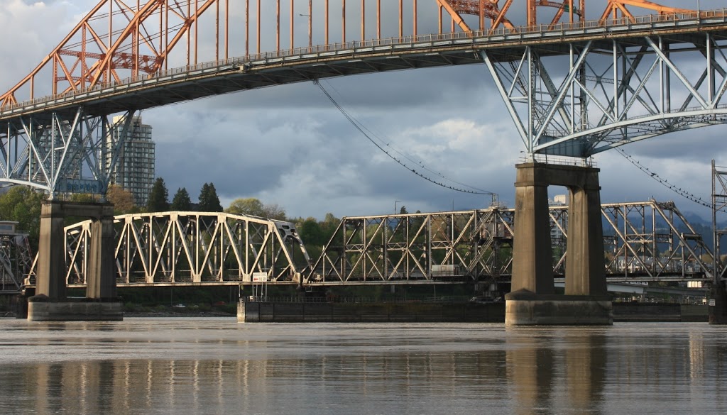
New Westminster Rail Bridge: still solid after 108 years. Please
ignore the big, showy, youthful, orange bridge next to it! 

Yet the Gateway Program has been silent about this imperative issue. Nothing has been done for several reasons; at least part being the difficulty of building an adequate replacement (read: two tracks, and not a swing or lift bridge that impacts rail schedules) in the spot where the bridge currently resides. Trains hate hills and the Navigable Waters Act requires minimum clearance over the River for fixed bridges: the Pattullo has 45m, the New Port Mann about 42m. The ground on the Bridgeview Side has an elevation of about 3m above the River, meaning the bridge would have to lose something like 40m between midspan and Surrey. That isn’t a problem if you are driving a car – a 6% slope is almost invisible to a car, and would require a 650m-long ramp, not unlike the current Pattullo approach. However, to a freight train, that is an insurmountable slope. Trains require a slope closer to 2%, and consequently the offramp on the Surrey Side would need to be 2km long!

For this reason, the idea of a tunnel under the Fraser at that point was considered in that same 2003 report on regional transportation needs. The navigable channel under the bridge is maintained to 10m depth through the dredging program (to accommodate 11m draft ships at least two hours a day – tides and freshets really mess with elevations when you use the top of an estuarine river as a datum – good thing we have geographers!). So the bottom of the tunnel would need to be something like 20m down, requiring a km-long slope from mid-stream to the surface at Bridgeview. Long, but not unmanageable considering most of it will be underground.

The New Westminster side gets more interesting, though. The current train bridge hits the land at about 5m above the river, just above Front Street. From the north pillar of the bridge, McBride would only be about 200m distant. A new 40m-high rail span could therefore only slope down to about 35 m elevation over that distance, which would put the rails on the green grass slope above Columbia Street. I cannot imagine how to connect those rails to the existing rail network without some sort of aircraft carrier-style elevator.

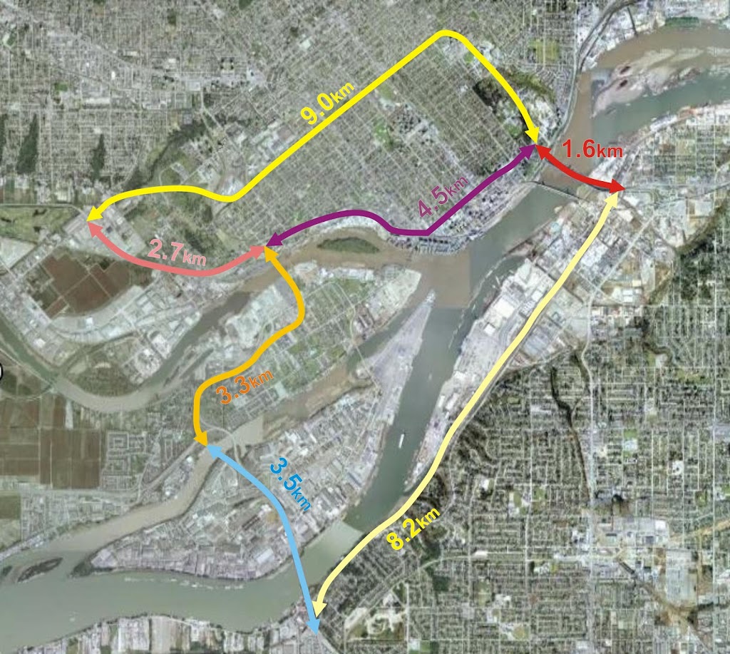
Bring an under-river tunnel in 20m below grade, and you can similarly forget connecting to the existing east-west rail line under the Pattullo Bridge. A new east-west connection would be required, and this is where things start to get exciting for New Westminster, as the only logical connection is a tunnel under New Westminster. A tunnel that connects the rails yards at Sapperton to the rail yards at Quayside. I can think of two ways these tunnels can go. But first, look at the current layout of rail lines in New Westminster.

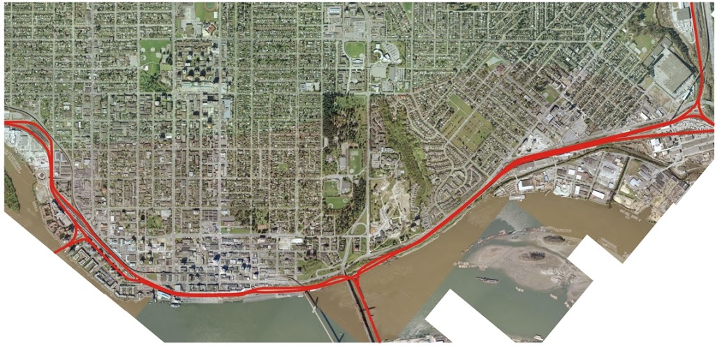
Existing rail lines in New Westminster, click to see bigger version.

A dreamer would envision three tunnels, each of them about the same length as the existing rail tunnel under North Burnaby. These tunnels would generally be deep-bored tunnels, not cut-and-cover, so there would be few issues with utilities, archaeological sites, or contaminated sites. Luckily, the materials that make up New Westminster hills are pretty competent and easy to drill (mostly sedimentary rocks of the Eocene Huntington Formation, if you care to know).

For the most part, this new infrastructure would be similar in size and scope to the existing Burnaby rail tunnel that connects the current Second Narrows Lift Bridge to the former rail yards around Still Creek. Not many people know about this 3.5km long rail-only tunnel dug in 1969. You may even have ridden your bike along the Frances-Adanac Bike Route and passed the building at Frances and Ingleton, thinking it is some sort of well-armoured house or Hydro substation, when it is actually a ventilation building for the train tunnel about 40m below:

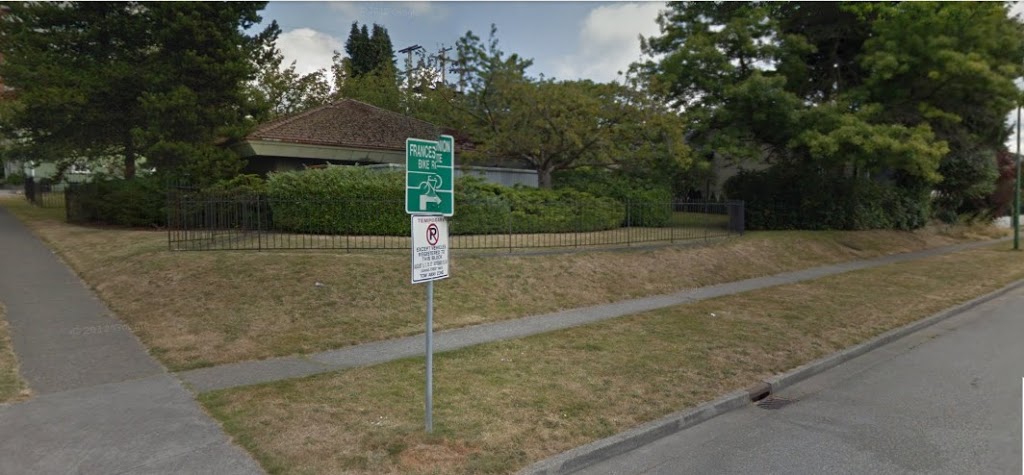
Tunnel Ventilation Structure at Frances and Ingleton in North Burnaby. 
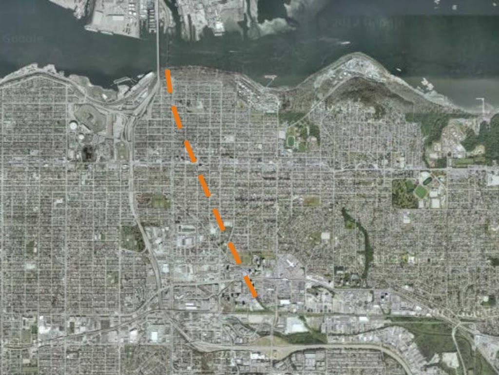
Approximate route of existing 3.5-km Burnaby Rail Tunnel connecting the
Still Creek area to the Second Narrows – the only Rail Crossing of Burrard Inlet.  

So envision this tunneling scheme (obviously diagrammatic – concept, not details) and think about the realized synergies!

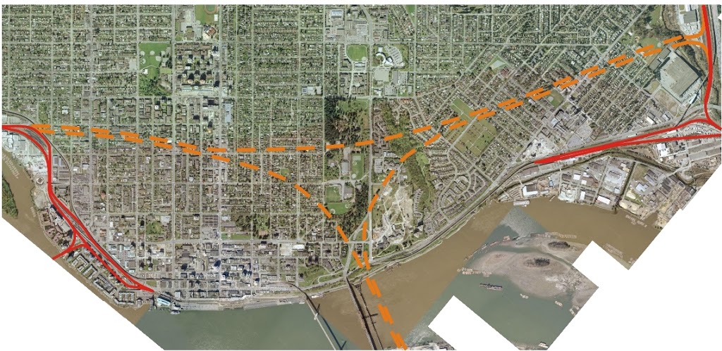
Proposed Tunnel Option 1: Dashed orange lines are bored underground tunnels,
well below City infrastructure. Red lines are retained surface rail. Click to enlarge.

We remove the bottleneck at the New Westminster Bridge by exapnding it to two rails and removing the swing bridge schedule hassles (remember, the #1 priority for goods movement in the region). This also opens up numerous possibilities for commuter rail, improved Via/Amtrak service, and opens up valuable industrial land in Surrey that now has long rail ramps on it.

There is no longer a reason to connect the Sapperton rail yard to the Quayside rail yard via east Columbia and Front Street. Those two yards can be connected via the east-west tunnel connecting the Hume Park area to the west foot of 4th street. The rail companies will no longer have to deal with the level crossings between the two, along with the speed limits, traffic and pedestrian issues they present. We have just achieved whistle secession between Braid and Stewardson.

The unnecessarily-complex level crossing at the foot of Braid would see a fraction of the rail traffic it sees now, as it would only see use as access to the small BNSF yard at Sapperton and spurs into the Braid Industrial Area. It would effectively dead-end at Sapperton Landing Park. The through-trains would be in the tunnel, resulting in fewer trains across these routes and increased safety and predictability for drivers.

At the other end, a tunnel dropping two lines below Stewardson near 4th would allow access to the Quayside yard, the SRY bridge to Annacis, and all points west. A re-configuring of the yard would allow the dead-ending of rails in front of the River Market. Your access problems to the Pier Park are solved, your whistle problems are solved, and Front Street becomes more viable human space again. (note this will not address the other rail-related noise issue in the City- the shunting and idling issues at the Quayside yard, but I’m sure James Crosty and Friends will have that situation managed soon enough.)

An alternate, and potentially cheaper, solution would look something more like this:

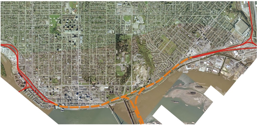
Proposed Tunnel Option 2: Dashed orange lines are bored underground tunnels,
mostly below City infrastructure. Red lines are retained surface rail. Click to enlarge.

We lose some of the benefits of simplification of the Braid intersection, but perhaps gain a consistency with the existing rail operations, although many of those operations in areas impactful on the City will be moved underground, just to allow acceptable grades between the sub-river tunnel and the existing rails at Sapperton and the Quayside. The total tunnel length is reduced (one 3.2km tunnel instead of three tunnels totalling almost 7.2km), but the interaction with existing utility, road and rail infrastructure is greater, and therefore the construction costs may not be much lower. There are people much better trained than I to advise on which actual tunnel configuration is optimum!

Another argument for these tunnels is that they help solve some of our actual traffic congestion problems. Every container that is on a train is a container that is not on the road. This project improves the competitiveness of the train system for moving goods from Vancouver Harbour and the DeltaPort to points east (including the intermodal yards in the northeast sector and the industrial areas on Annacis), and it moves all of these containers without trying to share space with other trucks, cars, buses  bikes, and the livebility of our city.

Yes, it is up to 7.2 km of tunnelling, but compared to a cut-and-cover McBride tunnel which would be the longest road tunnel in Canada, none of these rail tunnels would be longer than the existing Burnaby tunnel, and combined length they would be much shorter than the longest rail tunnels in Canada- actually a combined length similar to the combined bored and cut-and-cover tunnel for the Canada Line, except without all the expensive underground station costs!

So to summarize: we make the Port and rail companies happy by removing the big bottleneck at the New Westminster Bridge, we remove a significant number of level crossings, open up our waterfront, re-claim valuable downtown land for non-rail use, achieve our whistle cessation goals, and improve the Braid crossing safety issues, while improving rail connectivity and freeing up community streets. All for a cost that would likely be much less than that for an imagined cut-and cover tunnel solution for cars.

Here is a tunnel idea I could support.

The Coffee Crossing and bigger problems

New Westminster is a pretty pedestrian-friendly city, despite the hills. Our high urban density means services are always nearby, we have exceptional access to rapid transit, and our infrastructure is pretty good. Our City-wide “Walkability Index” is among the best in the Lower Mainland and Canada, and the City’s transportation plan emphasizes the importance of walking as a form of transportation, through the City’s ACTBiPed, and a Pedestrian Charter.

This is not to say everything is perfect. We still have too many pedestrians hit by cars, too few marked crossings, and accessibility challenges in some areas (including a general paucity of sidewalks in Queensborough). Overall, the City is doing a pretty good job, and the Staff and Council generally understand the issue, but there is always room for improvement.

Last week we had two news stories that demonstrate both the good and the bad.

There is talk that plans to “improve” the Coffee Crossing in uptown are on hold, and in this case, not fixing a problem that isn’t actually a problem is a good thing.

That pedestrian crossing is, actually, a very effective one for pedestrians, as Bart Slotman suggests in the article above. It is short, the cars are travelling slowly and they tend to yield to pedestrians more than most crossings. If there was any improvement needed, it might be as simple as getting rid of one or two parking spots (like where the gold Chevy truck is in the story above), to increase visibility for both driver and pedestrian. However, there is no need to spend tens or hundreds of thousands of dollars to install signals to “fix” a pedestrian crossing that basically works and is not demonstrably unsafe.

If there is any perceived problem with this crossing, it is that it emphasizes pedestrians over drivers. It is occasionally inconvenient for the minority of users because drivers may, on some occasion, need to wait for 10 or 15 seconds for a line of pedestrians to cross. In extreme events, this may stretch to 30 seconds (the horror). This “problem” is built on the assumption that roads are for cars, with pedestrians a temporary inconvenience. The alternative point of view (supported by the Pedestrian Charter) is that roads are for moving people, and people moving using their feet have as much right to the road space as people carrying 1500kg of metal and plastic along with them.

This intersection is in one of the busiest pedestrian-use places in the City – the businesses and residents of Uptown rely on a safe pedestrian environment to go about their daily lives. If the busiest pedestrian location in the City is inconvenient for drivers, they can move a block over. This crosswalk is an important part of that safe pedestrian environment. If it delays the occasional through-driver by a few seconds, then so be it.

The second story provides a great suggestion for what to do with the money saved by not installing lights at the Coffee Crossing. The residents of Massey Heights have been concerned for years about the safety of 8th Avenue through their neighbourhood, both for drivers and pedestrians.

The problems on the Heights part of 8th Ave are pretty standard, from a traffic-management view. The road is a major arterial carrying a lot of traffic through residential neighbourhoods. With the slope, the sightlines are often challenging, and it is easy to underestimate your stopping distances as the hills gradually steepen. An engineering response to this is to make the road very wide to improve sightlines, but this invariably encourages drivers to go faster, especially as there are no speed controls between Cumberland and East Columbia – it is a 1.5km long, 12m-wide speedway that bypasses narrower, more speed-controlled alternatives (6th Ave, 10th Ave, etc.). This rather sucks if you live in the neighbourhood or try to walk across 8th Ave.

The old-school solution to the pedestrian problem was to build a narrow, dank pedestrian tunnel under 8th around Richmond Street, to keep pedestrians from causing traffic to slow down. As unappealing as the tunnel is for most people, for most of that stretch of 8th, crossing the road has been a daunting enterprise. It is almost impossible at rush hour, as a line of a couple of dozen cars approach from the west, then as they come to an end, a line of several dozen cars arrive from the east. Better road marking and signs will not cause that line of cars to break just because someone is at the crosswalk – they are all trying to make the next light. This is the place for pedestrian-activated flashers.

The ACTBiPed and the Victory-Massey Heights residents have been complaining about this for years. It looks now like the City is going to put some resources towards fixing the problem, and they are looking for your input.

My suggestions? First, forget the tunnel at Richmond Street, and do the job as recommended:.

This should be a fully-signalized intersection, one with full crosswalks painted on both sides. Richmond Street is a major north-south connection, close enough to the Crosstown Greenway that it is a major pedestrian and bike route to the Hume Park area and to Burnaby. Given the nature of the intersection and traffic, and slope of the hill there, full stop lights are overdue.

As for Sherbrooke Street, I frankly don’t care if they close off Sherbrooke and Devoy (best ask the local drivers), and the sidewalk bumps help pedestrians (although they make things slightly less comfortable for cyclists). However, this is the place where a pedestrian-controlled flasher is needed. Traffic regularly hits 80km/h along here (despite the 50km/h limit), with long lines of cars between light signals at the distant intersections.

The same is the case for where Williams and McKay intersect 8th Ave, 300m to the west. This is another major pedestrian cross-street, where it is neigh impossible to cross safely as a pedestrian during rush hour. I suggest we need a second pedestrian-controlled crossing here. There is mention of “improvements” at that intersection, but no details provided. Clearly, all of the safety issues that exist at Sherbrooke also apply at Williams, and similar treatments are appropriate.

There is an on-line survey at the City’s website on the topic of 8th Ave improvements. You might want to fill it out right away, as it closes this Thursday. Please take 5 minutes and ask them to assure that pedestrian safety be the #1 priority in this residential neighbourhood. Accommodating through-traffic is important, but a distant second to the safety and livability of our neighbourhoods. We need a fully-singnalized intersection at Richmond, and pedestrian-activated flashers at both Sherbrooke and Williams.

Two (+) Upcoming Events (edited to add more panic)

It should be a couple of interesting weeks, and if I don’t post too often, I have some good excuses. I have said this before, but believe me, this time I am really busy.

I have both the Royal City Curling Club AGM next week (my report is written, but I may need to prep a speech and be prepared to be peppered by questions on my role as Ice & House Committee Chair) and the Environmental Managers Association of BC AGM and Awards Luncheon is also next week (I am expecting to return to the board as a VP at that event). There is also the Westminster Pier Park Grand Opening coming up, and I did my volunteer training for that yesterday. I also have an Emergency Advisory Committee meeting tomorrow evening. Don’t forget the first Royal City Farmers Market of the year is this Thursday (great fundraiser, by the way!).

Bonus last-minute panic-causing addition:
Sapperton Day is also this Sunday! See us at the NWEP Booth talkin’ transportation and Pattullo!

Although these are keeping be busy, there are two upcoming events I want to talk about here:

Tomorrow (fortunately, after the EAC meeting), there will be a Forum on the Future of the Pattullo Bridge at the River Market. Although the list of presenters is interesting, I can’t shake the feeling that this is a bit of a smoke screen.

The topic for discussion is what to do with the Pattullo Bridge after TransLink builds the new 6-lane bridge. There are some interesting ideas, including keeping it as some sort of linear parkway or re-purposing as development space. Having visited the original HighLine last year, I agree it is a compelling piece of urban infrastructure, and the impact on the part of Chelsea where it was built is undeniably positive. It is getting so every developer building an elevated walkway in every City in North America is putting a few trees on it and saying it is “a HighLine like design”.

HighLine, the type sample.

I’m interested to see what learned people have to say about this type of use for the Pattullo, but I can’t help but thinking about all of the people in this town turning themselves inside-out over a much less ambitious waterfront park very close to the Pattullo. I also wonder why, if TransLink is so convinced the bridge is in immediate peril of collapse, we are entertaining fixing it for a recreation or development space. So although I enjoy speculative thinking about the future of the City as much as anyone, let’s not take our eye off the ball here. The livability of our City is not currently threatened by a lack of elevated or waterfront park space, it is threatened by the risk of increased traffic resulting from a 6-lane Pattullo.

Ultimately, I think the best use for a refurbished Pattullo Bridge is as a transportation corridor with 4 lanes and improved pedestrian and bike facilities, or even three lanes with a counter-flow middle lane. If it can be fixed, I can’t imagine a better use for it than the one it currently serves.

Which brings me to the second event of note. Next Tuesday is a N.E.X.T.NewWest event featuring some random blogivator talking about the Pattullo Bridge.

In my natural envrionment: hiding behind beer.

I am going to give a very brief background of the Pattullo situation and talk a bit about the community open houses I attended and the City’s approach to the TransLink process. I will also have some interesting data to present about aspects of the plan, and then present a bunch of opinion about where the City should be going with its transportation system, and how the Pattullo fits into that.

It should be fun and informative, as N.E.X.T. is exactly the group of “New” New Westminster business leaders whom I was whinging about being too silent in the discussion of the Pattullo up to now. My only goal for the evening will be to convince as many of them as possible that they should be getting involved in the discussion, and not let these decisions be made without their important voice. I also hope to make a few of them laugh… with me, as opposed to at me. But I’ll take it either way.

I hope to see lots of folks at both of these events, as they demonstrate one of the strengths of New Westminster – a community coming together to discuss an issue from various different angles. The more voices we have, the more likely TransLink will listen to us.

More Advertizing (updated)

Do you care about the future of the Pattullo Bridge
…and the impact on traffic in New Westminster?
TransLink has decided to tear down the historic Pattullo Bridge and replace it with a 6-lane bridge.  By their own estimates, this will increase the number of cars crossing the bridge by 50%, and double the number of trucks! Yet TransLink has no plans to accommodate this traffic in New Westminster. So far, the only consultation they have had with New Westminster is to ask us which flavour or offramp we prefer.
Meanwhile, the City is working on a Master Transportation Plan, to better understand the goals and visions of the people of New Westminster. Through this plan it is hoped better-informed decisions can be made about our transportation future.
The City has made it clear to TransLink that it will only support a plan for the Pattullo that fits the City’s goals. The upcoming open houses are your chance to help form those goals…with TransLink moving fast on the bridge planning, this may be your only chance (see below) to have a real say on the project that will define traffic in New Westminster for the decades ahead.
City Staff and Officials will be on hand to answer your questions and address your concerns about the Pattullo or other transportation concerns in New West.
Your voice is needed at one of these important open houses!
Thursday, May 3, 2012.
2:00pm at Century House (620 8th Street, in Moody Park)
or
6:00pm at the Justice Institute (715 McBride Blvd, McBride and 8th Ave ))
For more information check in on the
City’s Master Transportation Plan website: tinyurl.com/NewwestMTP
or the New Westminster Environmental Partners website: NWEP.ca

Edited to add: The City is now also using a new piece of social media called “Place Speak” to collect opinions on the MTP and the Pattullo Bridge. It is just starting up, but you can go there to add to the conversation. Remember, though, to make your voice really stand out, you should still attend one of the May 3rd open houses. Without support of the citizens of New West, the City is going to have a hard time convincing TransLink that a proper consultation needs to take place.

A study in contrasts

I’m not even sure what to say about this.

Quote 1, April 3, 2012

Mike Proudfoot, CEO of the province’s Transportation Investment Corp., said modeling shows the Port Mann tolls will not cause any significant net diversion of traffic to untolled bridges, because other drivers now using those routes will switch to Highway 1 and pay tolls to take advantage of travel time savings.

Quote 2, April 18, 2012:

Commercial truck safety crews are confident they can handle the increased traffic along roads in New Westminster once tolls kick in on the Port Mann Bridge.

Why am I not filled with confidence by either of those stories?

Be at one of the May 3rd Master Transportation Plan open houses, unless you are completely confident that there will be no increase in traffic, and that those non-increases are going to be absolutely no problem at all.

Here is the quote you need to remember from that link:

“The City is also seeking community input on the proposed replacement of the Pattullo Bridge.”

Long winded weekend.

It was a long, long weekend. Mostly because people at the curling rink, the River Market and the pub were badgering me about this profile in the Record.

It is hard to talk about yourself and not sound like a narcissistic blowhard, especially when you are a self-aggrandizing blowhard like me, but I think it turned out pretty well. I figured if people wanted to hear me complain, they would come to this blog, so I tried to emphasise the positive in that interview. And as cheesy as it may seem, I really do like this City, for a lot of good reasons.

For example, a few people complain about missing crosswalks at a busy intersection, and guess what happens. A few days later, someone was out there with some white spraybombs putting some white lines down. It wasn’t fancy, but it worked! I’m not even sure if it was someone from the City or just some random community rabble, I kind of hope it was the latter, even though it makes me feel bad for whining about the problem on the internet and not going out there and doing it myself…

Then, on Monday, the City was out there in earnest, putting real reflective crosswalk paint down. They didn’t do a fancy job, but a temporary fix was all we needed, just to keep the crossing outside of a popular pub safe during the Canucks Playoffs, and until the final pavement cap can be put down on 6th. Thanks Guys!

True to the profile in the Record, I spent the weekend doing three things: Curling at the DonSpiel, Rabble-rousing, and working on my garden.

The DonSpiel is the season-wrapping fun tournament at the Royal City Curling Club. This is a bonspiel devilishly designed by long-suffering Royal City club member (and 2012 Mens League Champion Skip!) Don Smith, to squeeze the last bit of fun out of the season. The format brings novice and experienced curlers together and emphasises the off-ice-capades as much as the curling. It is a legendary good time… Oh did I laugh.

The Rabble-rousing part of my weekend was the glorious sunny Saturday I spent at the Royal City Farmers Market outside of the River Market at the Quay, catching the first tender sunburn of the season while talking to people about the Master Transportation Plan and the Pattullo Bridge consultations with some of the New Westminster Environmental Partners.

We were mostly handing out these:

Because that is our message right now: Show Up and Be Heard.

Based on some conversations we have had with people in the know, the Pattullo Bridge thing is coming on fast. The City is looking to the MTP process to get the voice of the people of New Westminster to take to TransLink, but TransLink has made their intent clear: They want to build a 6-lane bridge, increasing the daily traffic load entering New Westminster from Surrey be 50%, and doubling the truck traffic, with little regard for how that will impact Royal Avenue, McBride, or your neighbourhood.

The consultation has not presented the business case for or against the myriad of other options, nor has it even taken a cursory interest in the transportation plans, policies, or vision of New Westminster. Anything other that the single plan they have presented is not being considered. There are many in the City who suggest this is not true to the nature of “consultation”. Some of these groups are getting organized.

The Meetings on May 3rd will give the people of New Westminster a real opportunity to be heard on this issue, and the City needs as many people as possible to show up. Even if you think all of my opinions on the bridge are those of a crackpot, or the opinions of the NWEP are complete bunk, you still need to come to one of the City’s Open Houses. This is, most likely, your one and only chance to be heard before TransLink charges ahead.

Save the date. More to come.

Trucks on Royal

This is an issue that bubbled a bit during the last election. Most notably, Council Candidate Vladimir Krasnogor raised the issue of heavy truck traffic on Royal Avenue throughout the campaign. The issue didn’t seem to have legs, though.

I used to live on Royal Ave and 10th: a great condo in a great building. Our first experience with Condo ownership was a surprising success, mostly because the Strata Council was proactive, with a few very sharp members who were able to manage the books and keep the ship running. The only downside of the place was intersection of Royal and 10th. The pavement was pretty beaten up, with a huge volume of heavy trucks causing the asphalt to ripple dramatically. Although the route is only a “daytime” truck route, it only takes a few scofflaw drivers to give people the impression it is a 24-hour truck route. Laden trucks grinding up Royal between 10th and 8th were bad enough, but the crash bang of (seemingly empty) container trucks rattling over the rippled pavement while racing through the intersection on the downhill route can shake you filings out, and that one-in-a-hundred jake-brake user during a quiet summer night paints all drivers with a bad brush, even from 20 stories up.

I sympathized with the folks at City Hall even when I was phoning to complain, yet again, about the guy in the Celeste green wood chip truck with the wailing brakes who drove down the hill, wailing away, yet again, at 5:00am. The City Bylaw Officers did what they could with enforcement, but it was an endless game of whack-a-mole.

What are you going to do? Trucks are necessary for the operation of our society. Royal is on the Major Road Network, and therefore Metro provides money to maintain it, and they are not likely to remove this route from the MRN unless viable alternatives are provided. I hear people at the Master Transportation Plan open houses talking about how “cut and cover” is the solution to all truck traffic issues, without acknowledging the costs and other logistical issues (not to mention the tradeoffs) that come with those types of hard, expensive, engineered solutions in urban areas.

This intractable issue has come up again, as part of the discussions around the Pattullo Bridge. Like many lightly-scabbed-over intractable problems, an off-hand comment from Matt Laird peeled it open again, and got me thinking about the problem in a different way. While looking at the various off-ramp designs TransLink had offered us for their new Bridge, Matt asked why trucks had to turn right onto Royal from the bridge. I’m not sure anyone in the room got what he was talking about, but for the last couple of weeks, that question has been stuck in my head like the baseline of “The Lion Sleeps Tonight”. There. Now it’s in your head too.

So I got thinking about the question, and came up with this handy little diagram.

This measures the distance between key points relating to truck movements around Royal Avenue. I’m assuming that the South Fraser Perimeter Road will be completed and the Pattullo Bridge (in whatever shape or format) will continue to connect to East Columbia and Royal near McBride. The numbers indicate the distances between the important node points. So the distance from 124th and King George in Surrey (the intersection of the SFPR and Highway 99A) to the north foot of the Queensborough Bridge via Royal is 1.6km + 4.5km, or 6.1km.

So let’s look at what options truck drivers have while crossing the Pattullo Bridge (for the time being, lets ignore the trucks that have specific business in New Westminster, and talk about the through-traffic only).

Arriving at the Hwy99A/SFPR intersection from any direction, any truck heading to the TriCities is pretty likely to take the Pattullo, as the asshats at MOTI have decided not to connect the two most expensive road-building projects in the Province (Port Mann 2 Hwy 1 and the SFPR) with an intersection where they cross. These trucks will therefore be forced to cross the Pattullo, take East Columbia, and get mired in the Brunette / Braid intersection and Brunette overpass hijinks. (note, the UBE would definitively NOT have solved this problem, as the trucks want to get to the 8-lane Lougheed or the 10-lane freeway, not to a driveway-laden 4-lane service road through big box retail and casino entertainment hell)

Trucks heading to the northwest will typically stay on 99A up McBride. The only trucks taking Royal would be those heading west to the Queensborough Bridge intersection: the aforementioned 6.1km trip. If their destination is along Marine to points west, the logical alternative is to continue up McBride to 10th, then go down Southridge Drive to Marine at Byrne Road: a trip of 10.6km, which is only slightly longer than the Royal route (which is 8.9 km total). If their destination is the East-West Connector, then their option is the SFPR – Alex Fraser route, which is 11.7km compared to 9.4km along Royal. Considering the SFPR route will all be separated freeway, and not involve stop-and-go traffic lights, even most destinations in Queensborough might be better serviced from the southern route.

Now what about trucks coming from the E-W Connector? The only reason for them to use the Pattullo is to access the TriCities if they choose the longer Alex Fraser – SFPR – Pattullo route, which is quite a bit longer (13.3km) than the Stewardson – Columbia route (7.8km), so not likely. More importantly, if their destination is south of the River, they might be best off to cross the Alex Fraser right away, as they will get to Surrey sooner (11.7km of freeway vs. 9.4km of City streets), so no Pattullo access needed at Royal.

Coming from Marine Drive, the only reason for trucks to use the Royal-Pattullo route is to get to Surrey, and Royal is only one of the three options (Royal is 8.9km, 10th and McBride is 10.6km, and Queesnborough is 17.7km).

So again, except for local traffic, why do trucks need to be able to access Royal from the new Pattullo? Is a 10% longer route along less-restricted roads faster than a shorter route with hills, stoplights and commuters?

I guess one point to take out of this is that we need to understand the ultimate routing of these trucks, in order to service them adequately, not just whether a truck is “local” or not. If only 5% of the trucks are using Royal Avenue because it is a significantly better routing than any alternative, but because of that 5%, we build Royal into the quickest route, then that will attract trucks off of the alternative routes that are only slightly longer. We also have to ask the hard question: is accommodating those 5% of trucks worth the cost to the livability of our City?

These questions require better data to answer. As does the “local truck question”: are there better alternatives to service the trucks whose destination is New Westminster, separate from the through-traffic? Remember, “truck routes” only apply to through traffic (trucks with local business are not limited to these routes, but can use service roads to access businesses that are not on truck routes).

Maybe Matt and Vladimir are right – maybe it is time to start talking about taking Royal off of the MRN. Could such a move be timed to coincide with the opening of the SFPR? Would such a move put the Pattullo replacement project into a new light?

Pattullo and the City

Having attended both New Westminster workshops on the Pattullo Bridge Replacement being held by TransLink, and being on the Master Transportation Planning (MTP) committee for the City, I noticed there is a o lot of misunderstanding about what the City’s position is on the TransLink process, and how the City’s MTP process fits into that.

Big caveat here: I am but one member of the Master Transportation Planning committee, representing the Advisory Committee on Transit, Bicycles and Pedestrians. The MTP committee has 20+ members from various City committees and outside agencies, and is only one part of the entire MTP process, being run by City Staff and outside consultants, under direction from Council. Therefore, nothing I say here is in any way the official position of the MTP committee, City staff or Council, or anyone else other than me. It is, however, based on what I have heard said at various official meetings and unofficial conversations with staff and council.

At the TransLink meeting at the Quay on Thursday, I talked to School Board members and several other people in the community who are usually very much in the know, and I found myself trying to explain what the relationship between the MTP and the Pattullo Bridge consultation is. Unfortunately, it has been cast a bit in the media that New West is once again being obstructionist, engaging in Nimbyism, refusing to take part, and being generally petulant spoilt brats. This despite the attempts by City Council and TransLink to broadcast that this is not the case.

So I am going to presume to interpret how the City sees this process happening, based on conversations at the (public and open) MTP meeting and with City Staff and Council members (so interpretation ahead: Staff or Councillors please correct me if I am off the mark here!)
I don’t see New Westminster missing the boat at all here, but I see the City taking a pragmatic, responsible and measured approach.

The first thing you need to keep in mind is that this round of consultations on the Pattullo is the first round of a very long process. TransLink will be taking the results of this consultation (preliminary design characteristics) and then entering an “operation analysis” phase. The preferred design out of this process will be tested at both ends for everything from how it manages traffic flows, how it fits the existing traffic patterns, how bikes and pedestrians will be accommodated, etc., etc. TransLink will also start the (potentially lengthy) joint Provincial and Federal Environmental Assessment process. Both of these steps will include significant public consultation and discussion. Then they will have to deal with the financing model, hiring a concessionaire, negotiating land swaps, etc. Even after this initial consultation, TransLink is at least 4 years from any shovels getting into any ground, and at least 3 before we know whose shovels it will be, and where they want to put them.  In other words: there is no rush to provide all the answers right now.

As for the City, they are updating their Master Transportation Plan, last completed 13 years ago. The MTP process will take about another 12 months. If you look at this diagram, it shows the steps for the MTP:

The City is currently completing Phase 2 (information gathering) and is about to embark on Phase 3. That is the phase where the City looks at where it is today, transportation infrastructure-wise, and determines what the Goals, Values, Objectives are for the coming decade or two. It is the big “visioning stage”. In a couple of months, after some public and stakeholder meetings, and likely workshops, the City will come up with a set of Values and Goals that define what type of transportation infrastructure the community wants to see in the foreseeable future (and in this case, by “the community”, I mean the residents, the businesses, the staff and the elected officials; everyone involved in the MTP process).

Then, when those Values and Goals are determined and formalized, the City will be in a position to approach TransLink and say: “Here you go. Make your plans address this”.

I don’t think there is yet a concrete idea of how that discussion will take place: will there be public consultations? Will the City report out to TransLink or do a joint consultation and reporting? No idea., but the point is that the City will take a bit of time right now to get a better understanding of that the community of New Westminster wants in a transportation system, then they will be armed with that knowledge when they go into negotiations with TransLink on how the bridge they want to build fits those parameters – or if it can even be made to fit them.

In the meantime, TransLink will be continuing to work on their process, but New Westminster will not be missing any boats here. We will be through that Phase 3 work in only a few months, TransLink will not likely have any operational plans in place for a year. When the MTP is at a point where useful data is available for TransLink, TransLink will be in about the same position as they are now. More importantly, TransLink knows and understands that this is the route the City wants to take, and seems to respect that decision.

So, if you really want to influence the Pattullo Bridge design? My advice is to get involved in the Master Transportation Plan process. Come to the meetings, attend the workshops, follow on-line, and provide your input at every opportunity.

MTP Open House 1.20

If you missed the first open house for the Master Transportation Plan, or would like to arm yourself before the St. Valentines Day Messaging, the presentation materials are available on-line at the City Web Site, which provides me the opportunity to go on about some of the details therein. I am completely copying these graphics here without permission form the City, so I suggest only New Wesmtinster taxpayers, who paid for them, should click on them to see full-size versions.

The fifth slide (above) provides the first really interesting data. The bar chart shows Metro Vancouver municipalities ranked by “mode share”. That is the proportion of “trips” taken by modes of transportation other than driving a car. It is pretty clear from this bar chart that New Westminster is already a regional leader in sustainable transportation, with a mode share of 36%, second only to those dirty bike-lane hugging hippies in the City of Vancouver.

What I take out of that chart, though, is a demonstration that infrastructure matters. The top three Cities are those with the complete integration of the SkyTrain. The next two are also well serviced with transit, with the SeaBus an important part of their infrastructure. All of the top 5 have put serious investment into bike lanes and pedestrian amenities. They have all put an emphasis on building compact transit and pedestrian friendly town centers.

Now scan down to the bottom of that list, and see lowly old Langley City. Aside from its abysmal transportation infrastructure and complete commitment to automobiles, Langley City has no excuse for this. It is compact with relatively high population density (2,500 per sq. km., compared to New Westminster’s 3,700 and Burnaby’s 2,200, which are all way higher than North Vancouver District or Langley Township, which are both under 500).  It is relatively flat with a good balance of industrial, commercial and residential land. This 9% is no surprise, however, to anyone who has tried to traverse Langley City. No cycling facilities at all, disconnected and disregarded sidewalks, a half mile of parking lots separating every business. About the only infrastructure it has is a Bypass Highway and the Big Box Hell that is 200th Street. As a cycling buddy of mine once said, reading a road sign: “Langley Bypass. I don’t care where you are going, that sounds like the right idea.”

What’s worse: the Mayor of Langley City, Peter Fassbender, is the vice-chair of TansLink’s Mayors Council. I’m not sure if the 9% should be more embarrassing for him, or if TransLink should be more embarrassed that he has been elevated to help lead the region in Transportation when his own City serves as cautionary example for the whole region… but as usual, I digress.

The walking numbers are not surprising. New Westminster is a great City for walking, and the hills are less of a barrier than some people (Such as the Downtown BIA) suggest, as long as the sidewalk infrastructure is there to make the walking environment pleasant. The map shows that Connaught Heights and Queensborough lag behind as far as walking infrastructure go. The “missing link” between Point Royal and The Quayside really stands out though…

The bicycling infrastructure info is actually a little disappointing. The cycling mode numbers are lower than I would expect, and the cycling network is distressingly incomplete, 13 years after the cycling plan for the City was laid out. Even the designated bike routes we have are either suffering from erosion from disregard (BC Parkway anyone?), or are bike routes in name only, being just as unfriendly for cyclists and completely unmarked as they were 20 years ago (try to cross 20th street on the London Bikeway, I dare you).

I love the topography map they have on the 10th slide. Whoever thought of that map must be a genius. It shows that most of New Westminster is not really that hilly. There are only a few areas where the slopes cause a real challenge to recreational or casual cyclists – the Downtown-Uptown link, the Brow of the Hill, and Sapperton. I hope with this Master Transportation Plan, we can re-draw the cycling map with this in mind, and find creative routes to make these slopes manageable for more cyclists. The City’s Bicycle and Pedestrian Advisory Committee already identified a route from New Westminster Station to the Saint Mary’s site that connects relatively gentle slopes with very short stretches of higher grades, with only a few missing links that need to be connected. The advantage of the current low mode share is that it should be easy to increase in the foreseeable future.

Transit is a good news story for New Westminster, and a large reason why we have such impressive mode share numbers. As I said before: infrastructure matters. Five SkyTrain stations for 60,000 people is one of the remarkable advantages of being a compact City in the centre of Metro Vancouver.

The problem comes down to frequency. The diagram above shows AM peak time frequency, which is pretty good. However, the City’s largest employers are not 9-to-5 mom-and-pop operations, but have a lot of shift workers. We also have a large lower-income population (due in part to our large rental property stock) who tend to also work in less traditional jobs. The reality for many people in New Westminster is that much travel for work is during off-peak times, not to mention travel for play. When transit service drops to 30-minute, or 60-minute service, it becomes completely unreliable. Especially in a place like Queensborough, where 20 minute bus service for a 15-minute ride to 22nd Street mean that it can take more than half hour at the best of times just to get to the SkyTrain Station you can see over there on the Hill. Once we hit 11:00pm, much of the transit frequency drops to zero.

Of course, this is slightly out of the scope of the City’s jurisdiction. there is little the City can do but lobby TransLink to improve service. Unfortunately, we have been going the other way of late. What the City can do, however, is make sure the infrastructure on the ground is there to make using transit easier. For example, the City, as a general rule, lacks bus shelters. There are also several decisions we can make to prioritize cycling and pedestrian infrastructure improvements at vital transit links. Finally, we can (outside of the Master Transportation Plan, mind you), continue to encourage dense land use at our major transit nodes, like we have done at New Westminster Station and Sapperton Station, and are looking at for Braid Station. How long can 22nd Station be surrounded by single-family homes?

Slide 16 was interesting for a few reasons. The numbers that really stood out for me were 4,300 vehicles per hour on the 4-lane Pattullo Bridge compared to 3,500 on the 4-lane Queensborough. Who would have thought the lil’ old Queensborough carried more than 80% of the traffic of the big bad Pattullo? But I also don’t understand how we can have 3,000 vehicles on both sides of the bridge, and 3,500 over it… there is something funny about where these numbers were collected and what they mean for that intersection. I suspect this also argues pretty strongly towards saving a ton of money and and replacing the Pattullo with a 4-lane structure, but another post, another time.

It was also interesting to see how the intersections we all love to have performed when measured by actual delay relative to their design traffic volume. The stand-out is that the intersections on 20th perform fine. This is a surprise to those backed up on 20th, or the people of Connaught Heights and the West End who can’t get out of their neighborhoods due to the gridlock on 20th. this also reflects a recent traffic study on 20th done for the City by another consultant. Long and short: the problem is the Queensborough Bridge. There is nothing we can do to improve 20th street except re-write the Queensborough Bridge interchange, which is Provincial jurisdiction and has already had a large pile of cash concerted to concrete in recent years. I think the best approach here is to re-design the traffic system on 20th to make it most useable by Connaught Heights and West End Residents, and let the through-traffic back up into Burnaby. It may be a simple as redesigning the traffic light signals…

The good movement info here is the one that has so far generated he most discussion. The City’s survey has reflected what TransLink has said all along: about 40% of New Westminster Truck traffic either starts or stops its trip in New Westminster. A few people (including Councillor Chuck Puckmayr at last week’s Committee of the Whole meeting), have questioned the methodology that resulting in the is number. I am more interested in where in the City these stops are happening – are they all going to Kruger? Are they driving across the Pattullo and through downtown on the way to Queensborough landing? Just how many semi-trailers full of food does Safeway need in a week? I really don’t know. But that kind of data might be useful.

The other part of the goods movement discussion is already popping up in the local media, and that is the future of truck traffic on Royal Ave. I think the issue of directing all commercial traffic to Royal is a big one, especially as we are going to have another school built right on it. There is strong pressure right now to make Royal the truck route, which will effectively increase total truck flow through the City. I think that is a bad idea, for various reasons. But again, this is already too long a post, so I will address that another time.

Master Transportation Plan Open House 1

Yesterday was the first Open house for the City’s new Master Transportation Plan process. Right off the bat, it looked like the turnout was great. I would put the over/under on total attendance at 90, if you include the staff and a few City Councilors (but, notably, not the Mayor). It was no donnybrook, but for a preliminary information session held on a busy night, it was good to see so many people are interested in the process. 

The Open house featured poster boards with some of the preliminary info collected by traffic counts and surveys, and a short presentation providing details on some of the posters, and giving a broader view of the process ahead. There were also some opportunities to add your comments to post-it boards, and to fill out a survey of pretty general questions. I have a few comments on a few interesting facts and ideas provided by the posters and presentation, but I’ll cover those in a later post. Here, I want to talk more about the feeling in the room. 

From listening to the conversations, most vocal concerns could be summarized into one of three broad categories: 

1) Through-traffic is a problem, but we can fix it once and for all by doing “x”; 

2) The intersection of “x” and “x” is the worst in the City! It needs to be fixed; and 

3) Why aren’t more tickets given out to bad drivers / cyclists/ rat runners/ anyone but me? 

Of these, number 3 has the least to do with the Master Transportation Plan. It speaks somewhat to a poorly functioning transportation system if systemic lawbreaking is the normalized way to operate the infrastructure, but targeted enforcement is really a complex issue involving driver education, signage, the police, and the community. The Master Transportation Plan will hopefully result in a better-integrated system that reduces the bad behavior of users, but that is rather secondary to where we are here. If traffic enforcement is really a passion of yours, why no join the City’s Neighbourhood Traffic Advisory Committee… they always need help! 

Number 2 is sort of what this is about. The solutions found might pick out a few key intersections and areas for improvement of the transportation network, but the bigger ideas will come in answering questions about how we want our intersections and other infrastructure to work, and how the various bits of the infrastructure can work better together. 

Number 1 is a big part of this. However, I bet the problems are more complex that we think, and that the solutions will not be simple ones. Unfortunately, some of the problems will not have a satisfying solution at all (Queensborough Bridge, anyone?), but that doesn’t mean this process is not useful or cannot change the way we approach these problematic areas. 

After the presentation, there was a bit of time for a few questions from the audience, the answers to which I can paraphrase here (yes, both the questions and answers below are paraphrased, any error of fact or language is mine, I tried to catch the gist of the conversation, if not the detail). I have added my comments after each Q&A point. 

Q: You say 40% of trucks are going to a destination within the City, but what about the rest of the traffic? It would be interesting to see how much of the car traffic passes right through.

A: No answer was offered, as it seemed like more of a statement than a question. 

This, more than any other point, is the big gripe New Westminster has about traffic, and the gripe our neighbouring communities have about us. I concur that it is important for us to get this number, because it seems to range depending on whom you ask: 60%? 80%? More? And so much of the conversation in New West is about it, we should start from a factual base. The strange part in this discussion is that many people who think this is our #1 problem also think the solution to too much through-traffic is to blow the bank on building infrastructure to accommodate more through-traffic (freeways through, around, or under the City). 

Q: How does this align with the proposed Pattullo Bridge project?

A: The Pattullo Bridge project is the jurisdiction of TransLink, and will include its own public consultation process, likely starting as soon a February 

However, the data collected for this plan, the impacts of the Pattullo refit/replacement, and the impacts on New Westminster when the Port Mann II comes on-line with its tolls, will all need to be considered as part of the City’s planning. I didn’t get confirmation on this, but I assume TransLink will be one of the agencies identified as a key stakeholder in the entire MTP process.

Q: This City is right next to the River- is there any consideration to using the River for transportation?

A:We don’t know of any plans to move passengers on the river that have gone past the very-high-level concept phase, but there has been discussion of this in the past. Port Metro Vancouver will be one of the Agencies invited to take part, and they have been invited to have a seat at the table here

Goods movement on the River has been a pet peeve of mine for a while, but I will save my strong opinions about how Port Metro Vancouver is screwing the entire MetroVancouver area for a later post. 

Q: What is our clout, jurisdictionally? If TransLink and Province and our neighbouring Municipalities have different plans than us, what can we do about it?

A:Some roads in the City are Provincial, some are part of the Major Road network, and are TransLink, but most are owned by the City. We work with these other agencies, and also, the UBE experience taught us that a strong, united community can have an influence. Experience has shown that a City that has a well-articulated Master Transportation Plan is in a better position to negotiate with other agencies to protect the goals of that plan

This was a great answer, and speaks to the importance of us not only putting a good plan together, but also acting on it to demonstrate that our community supports the goals outlined in the plan. 

Q: What about the UBE, are we going to address that issue as part of this?

A: If the UBE is identified as an issue during this process, then we can look at potential solutions to that issue. However, TransLink has taken the UBE off the table, and are not planning to build it anymore. That project was a TransLink one, with some Federal money. 

The UBE is dead, and the North Fraser Perimeter Road is at least in a very, very deep coma, the chances of it coming back are not nil, but are vanishingly small. But many of the problems highlighted in the UBE discussion (rail crossing safety, access for the Braid Industrial Area, the Braid and Brunette intersection) have not been addressed once TransLink’s approach to the solution was found to be unacceptable. I think there are creative solutions to these issues, and I hope having TransLink, that railways, Port Metro Vancouver, the Truckers and Coquitlam at the table will help us find some common understanding on these issues, if not a solution. 

Q: Are we working with the neighbouring communities, and have Urban Systems tracked the success rate of their previous clients for these types of Plans?

A: First question: Yes, neighbouring Municipalities will be involved in Agency Workshops. Second question: Yes. In their experience, most clients have implemented 50 – 70% of their plans 10 years after the plan is finalized. An interesting nuance is that sometimes the projects completed are not those that necessarily best suit the goals set forth in the plan.

That second part might need some clarity, I can think of an example where a City with the goal of “Improving Pedestrian Safety” may get a big grant to build a connector road in an underserviced area, but defer the sidewalk improvements to a later date, to take advantage of a short-term funding opportunity. Or someone like Rob Ford gets elected and decides to tear up an integrated cycling network, and replace street cars with subways, resulting in increased car-dedicated road space. Even the best laid plans sometimes get nuked by bad politics. 

If you missed the Open House, there will be another opportunity on the afternoon of Valentines Day at Century House. Nothing says “I love you, Honey” like skipping off work to take your date to at a community open house on transportation policy planning.