Q2Q, again.

This Post is actually an extended response to the comment by Ken, a Quayside resident and community builder, to my previous post about the Q2Q bridge. I thought his comments raised enough issues that I couldn’t do it justice just replying in a comment field!

Thanks Ken,

I will try to address your questions, but recognize that much of what you talk about occurred before my time on Council (so I was not involved in the discussions) and I respect that you have a much more intimate knowledge of the conversation on the Quayside over the last decade than I do.

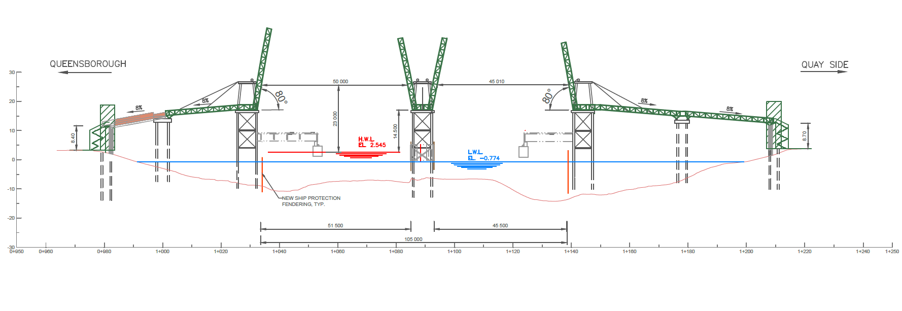
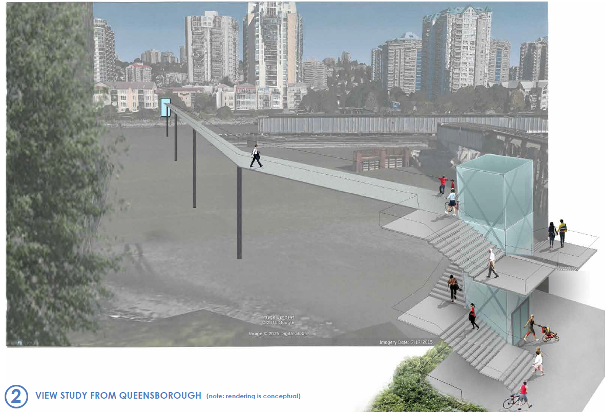
The project has indeed gone through various iterations in its history, and the initial plans ( here is a link to a report from the time) were to reach 22m of clearance to develop a fixed link that would get adequate clearance that we would not need Navigable Waters permission (read- not specifically need Marine Carriers permission) which required essentially the same height as the Queensborough Bridge. Conceptual drawings were developed based on the site conditions and some baseline engineering, and very preliminary cost estimates prepared. That concept was indeed reviewed by the Port (at that time, the Vancouver Fraser Port Authority) and note they even at the time preferred an upstream (east of the train bridge) location (see page 12 of that report I just linked to). Note also: that report suggests elevators at each end to improve accessibility. This is the concept that first went to public consultation, and concerns were heard about the need for long ramps that would have nonetheless been very steep, the overall height, the fate of the Submarine Park, etc.

The only alternative to all of that height was a swing/bascule bridge. To explore this option, the City asked some engineers to sketch and (very preliminarily) price some alternative concepts, including a bascule and a sidewalk attached to the rail bridge. The City again took these preliminary concepts to public consultation, and the bascule design clearly came up as the preferred approach, even recognizing it was potentially more expensive.

Now that a preferred concept was (hopefully) found, and the Q2Q crossing once again received endorsement from the new Council, it was time to actually pay a little more money to engineers to further develop the preferred concept to a level of detail that would allow screening for Port review. Not enough development for a full review, mind you (that will likely take several hundred thousand more dollars in engineering and environmental consultant fees and will no doubt also result in adjustments of the concept), but enough that it is worth the Port’s time to look at our concept and provide a detailed regulatory screening and provide us a pathway to approval.

That is pretty much where we are right now, and for the third time, this concept is coming to the public for review. The only thing I can guarantee you at this point is that if (and it is still an “if”, despite general Council and public support) this project is completed, it will not look exactly like the drawings you see on the page today. There is much engineering to do, environmental review to perform, and more public discussion to be had. Satisfying the Port’s environmental review will be months once we get to that point, and we can guarantee it will require some design adjustments.

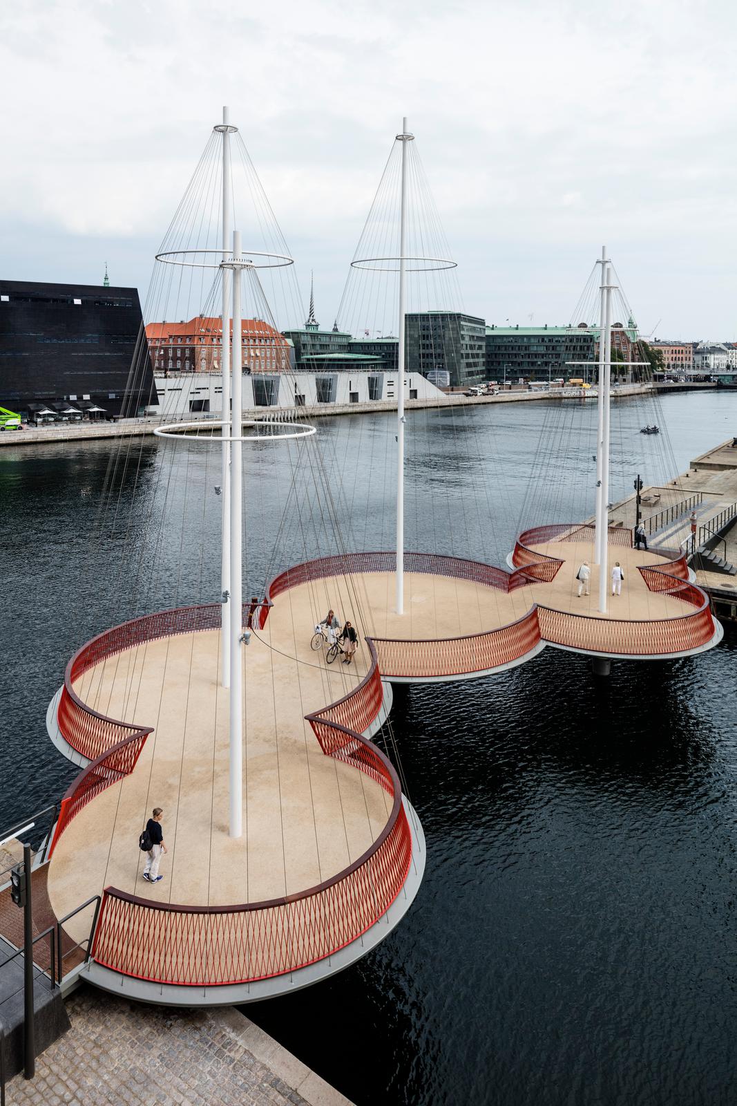
There are also other adjustments I think we need to see based on public feedback this time around. Although I have held my cards close to my chest because I don’t want to prejudice the public consultation, I will admit up front that there are two things in particular I cannot tolerate in the plans as presented at the open house: the 8% ramps simply do not meet modern standards of accessibility; and the closing of the bridge at night is not an acceptable way to treat a piece of public active transportation infrastructure. I’m prepared to accept that we cannot have the Copenhagen-style transportation amenity I would prefer, but I am still hopeful we can find a compromise that provides an accessible, reliable, and attractive transportation connection. We are not there yet. (And please remember, I am only one member of a Council of seven, and I cannot speak for them).

To answer what seems to be your main concern, I don’t know when the Marine Carriers were first consulted on this project, but the Port (who provides the Marine Carriers their authority) were clearly involved from day 1. They preferred an upstream location (now prefer a downstream one) and created the 22m by 100m “window” that led to the original 22m-high bridge concept, and have now led to evaluation of several swing/bascule concepts. Clearly, the City and our engineers have been searching for a creative solution to make what the politicians and public want mesh with the rather strict requirements of those who regulate the river and transportation. But serving those two/three masters is why the City is taking this iterative, slow approach, and why “plans that keep changing” are a sign of progress, not failure.

One thing to think about is that every step of this process costs more than the previous step, and moving backwards costs most of all. As engineering analysis and design gets more detailed, it gets more expensive, so we don’t want to do the detailed work twice. We could have asked for a ready-to-build concept a decade ago, and done enough detailed design that we just needed to pull the trigger and we could have it built within a year, and then taken it to public consultation. But if things are found that don’t work (i.e. the initial 22m height), we have spent a lot on a concept we now need to spend more on to change. Instead, we do feasibility studies, take it to stakeholders, the public, the regulators, and are given feedback. We then develop the concept to get more engineering done, and again have a look at the result and either move forward or change track depending on feedback.

This is a responsible way to plan, design, and pay for a public amenity. It is an iterative process, because as a government, we need to do our best to meet the needs of residents, of taxpayers who are footing the bill, of the regulations at 4 levels of government that have a thousand ways to limit our excesses, and of people who may be impacted by every decision we make.

If a government claims to do three years of stakeholder and public engagement, detailed engineering analysis and business case development, then turn around and deliver to you the exact same proposal they managed to render in a 3D model three years ago when the analysis started, then you know their consultation was bunk.

And I guarantee you, for every person who complains “this project has changed since the public consultation”, there are two who will say “public consultation never changes anything, they are going to ram their idea through regardless of what we say”. Actually, the same person will often say both, completely unaware of the irony. And that is why I appreciate your honest comments Ken, it sounds to me like you are trying to understand, not just complaining. So please provide your comments to the Engineering department and to Mayor and Council, and you will be heard!

Q2Q Compromises

The Q2Q bridge is an important project for New Westminster, and one I support. It is, however, a project with major challenges, and I am glad we are at a stage where the next phase of public consultation is taking place, so we can talk about some of those challenges, and what they mean to the City.

First off, I need to put my comments on the Q2Q into context, in relation to my position on Council.

The Q2Q concept was developed long before I was elected, even before I started to rabble-rouse in the community on transportation topics. However, I have expressed strong support for the project for years, even piping up to challenge some of the past opponents of the concept. I have always believed, and continue to believe, that the Queensborough community needs to have a reliable, safe, and accessible connection to the “mainland” of New Westminster, and that connecting the beautiful waterfront greenways of Queensborough to the Quayside boardwalk will have huge benefits for both communities. When the topic came up during the election, I was quick to say I supported the project and wanted to see it built as soon as possible.

Now that I am on Council, and am (in part) responsible for getting this project done, the brutal reality of the project has set in. The bridge some of us may dream of may not be possible in this location, and the development of palatable compromises is daunting and frustrating at times. It is becoming a lesson for me about the reality of planning for community infrastructure when a local government’s power is so limited.

If someone were to ask me what I wanted to see in a Q2Q bridge, it would look something like this:

Click
(typical, ask an urbanist geek about a design, he takes you to Copenhagen)

The bridge would be approximately the elevation of the boardwalks on either side, fully accessible, would be at least 3m wide, and would have an interesting design aesthetic that creates some regional buzz when it is built. As marine traffic would need to cross, it would have an innovative swing style that was integrated in to the design, and was an eye-catcher such that the 5-minute wait for the boat to cross was not something that irritated you, but intrigued you. It would even have areas over the water where you could sit, have a picnic, drop a fish line in the water, or take photos of crossing trains, passing boats, or overhead eagles. It would also represent an easy connection for people commuting by bikes, people out for a stroll, people pushing kids in a stroller – a seamless connection across the river.

But that ain’t going to happen, because the City doesn’t own the river. Although the North Arm of the Fraser at that location is a significant industrial transportation corridor regulated by the Navigation Protection Act and Port Metro Vancouver. I cannot emphasize enough that the people who make a living moving things up and down the river would much prefer no bridge there at all, and due to the nature of the regulations, the people working the river get the say about what goes in, on, or over the river. If they don’t agree, nothing gets built.

The “they” in the case of the North Arm of the Fraser River are the Council of Marine Carriers. They use the North Arm of the Fraser to move barges, boats, booms, and all sorts of floating things. There are no alternate routes, and their business relies on it, so they are pretty motivated to keep the North Arm accessible.

If you haven’t noticed, the train bridge connecting the Quayside to Queensborough is open most of the time to marine transport, and only swings closed when a train needs to cross the river. This would not be a great situation for the Q2Q bridge if we want it to be a reliable transportation connection that pedestrians and cyclists can rely upon. We need a bridge where the default position is closed (to boats), that only swings open when the boats go by, with a cycle quick enough that it won’t cause major inconvenience for either user group.

For the bridge to operate like this, the Marine Carriers have determined a clearance of 14.5m over the water is required. This would permit enough boats to pass under without opening the bridge that a default-closed position is acceptable to the folks who work on the river. This 14.5m makes for a pretty challenging crossing for cyclists or pedestrians with mobility problems. Hence, we can’t have the bridge we want.

q2qdrawThe question then becomes – how do we get people up to 14.5m? A ramp that meets typical mobility-access standards (i.e. no more than 5% grade – and yes, I am aware and frightened that 8% grades are shown on the rendering) would need to be about 250m long, even longer if we add standard landings at set distances. This would be expensive, and create a long visual intrusion for the Quayside residents next to the bridge. Stairs wrapped around an elevator column would have a much smaller visual impact, and if we can avoid the design mistake that led to a completely unacceptable delay on the Pier Park elevator (yes, we can), the size and scale of that structure is a good estimate of what the bridge landings would look like.

This image is *very* conceptual

I would love to see some creative alternate approaches, and we may see some coming from the engineers we hire to build the bridge. The corkscrew ramps at the southern foot of the Golden Ears Bridge seem very effective to me, and are of the same scale vertically, although I’m not sure we have the footprint area to take the same approach:

geb
…and I have my doubts whether Port Metro Vancouver would allow us to build such a structure over top of the water. It has already been suggested that the structure as proposed would require the highest level of environmental review (“Type D”) which makes it sound like a pedestrian and cyclist bridge will somehow have a bigger environmental risk than a coal terminal or LNG export facility.

You may also have noticed the plans for the bridge shifted from being slightly upstream of the train bridge to slightly below. The upstream side as a little better for the City, as both landings work better, but the downstream was deemed safer for boat traffic. Unfortunately, this means the landing on the Queensborough side is going to be much more complicated (read: expensive) to build.

Alas, we are stuck with what we have. I can complain about an industry group having more power than an elected local government about how our river is used, but as we learned in the Fraser Surrey Docks coal terminal discussions, the Port does not answer to local governments, but to their own mandate, and Sunny Ways are not likely to shift their business model any time soon.

So we will do what we can to build the most accessible, most convenient, and most user friendly bridge within the constraints given us, even if it isn’t as elegant as one we might see in a place like Copenhagen.

Stroads

Can we avoid a stroad problem in New West?

The word “stroad” is a slightly tongue-in-cheek portmanteau combining “street” with “road”, and it is becoming such common parlance in city planning that even small towns in Pennsylvania are talking about how to deal with them. The term came from people who understand the difference between how a “street” operates, and how a “road” operates. The former is a place where people do things, like socialize and perform commerce; the latter is a conduit for travel to get somewhere else. The term “stroad” pinpoints the problem created when you try to combine those two mutually exclusive uses into the same space.

I would argue that New Westminster has very effectively dealt with one stroad in its midst when the Council of the day put Columbia Street on a road diet. I remember the boo-birds talking about the disaster that would befall the City, and many of them still pop up to complain about pedestrian bumps or crosswalks or any other thing the City does to make the pedestrian space safer. Columbia is not back to being the Miracle Mile of the 1940s, and it never will be. However there is no doubt it is a better place for walking, for shopping, for living and for driving, than it was in the 1990s.

stroad5

Stroads are rarely created intentionally, they evolve into existence, with a bunch of small (and at the time, seemingly rational) decisions. Most commonly, a city finds one of its shopping streets is increasingly used by through-commuters. In hopes of eking some value out of this apparent windfall, automobile-oriented development happens along the route, displacing the existing landuse with the intent to capture the fleeting attention of through-commuters. This (often strip-mall commercial) development also attracts local drivers who used to shop on the street, and now blend with the through-commuters. Congestion is exacerbated, and the engineering solution is to increase capacity. You widen the road, removing on-street parking if necessary, which requires you to build parking lots, further separating the road from the businesses, and creates in-out driveways or more light-controlled intersections, which slows the through-drivers. To fix this, you put in a left-turn lane or two so the through-traffic doesn’t get stuck, then a right-turn lane to get them even further unstuck. Which kind of works for a while (see Byrne Road and Marine, or Kingsway at Metrotown), as long as you have a bottomless asphalt budget.

stroad3

All of the sudden, you have a road in the middle of your City right in the middle of the street in the middle of your City. Anyone who wants to try to put value into the street by using their local commercial businesses discover the shops are behind expansive parking lots that are hard to get into or out of, and walking across the street means braving 40 metres of asphalt where the people trying to turn right through the crosswalk are separated from the people trying to pull a left turn across traffic by the people in between speeding along to be the first to get to the next red light, frustrated by all the traffic. So, complicated light timing, “pedestrian islands”, or expensive overpasses are required to make the space marginally safe for people who failed to bring along 3,000lbs of metal when they went to buy a loaf of bread. And we have built a stroad.

stroad4

Stroads are expensive to build and maintain. They move traffic poorly, yet provide the appearance of moving it well, which paradoxically increases induced demand while not actually increasing capacity. They are dangerous for all users, but especially for cyclists and pedestrians, who end up avoiding their chosen mode because the stroads are so uninviting. Worst of all, they strip away the value of expensive and precious urban land space, and contribute less to the local economy than an active street. They represent a planning failure, an engineering failure, and a leadership failure that must be avoided in modern urban areas.

So when you hear about plans for East Columbia Street, 12th Street, Ewen Avenue, 6th Street or 20th Street, or any of the busy streets in New Westminster, think to yourself: do we want this to be a street, or a road? Without first making that distinction, we will inevitably hedge towards a stroad, and end up with neither.

Predictions before Results

The polls on the Translink Transit Transportation referendum plebiscite are closed, the ballots are filled in, but the counting is only beginning. The message from ElectionsBC is that turnout was slightly higher than expected, so the counting is going to take a little longer. It is being suggested that it will likely be three weeks before we have results. The cynic in me suggests the Friday before the week where everyone is trying to decide which weekend to make extra long around the mid-week Canada Day is the perfect time for the provincial government to announce the results of something they really want to avoid talking about, so prediction 1 is that “results day” will be June 26.

I am a guy who likes the occasionally wager, but I’m not taking any bets on the referendum plebiscite result. I think the count will be closer than anyone expects (within 5% either way), but you would need to give me positive odds to make any kind of bet. The turnout is higher than we anticipated, which could be good (the YES side really motivated their voters) or bad (the NO side didn’t throw their ballots away in disgust, but made the effort to vote), and the spread regionally is a lot flatter than I thought.

If you really want to speculate, you can have some fun sticking numbers into Brad Cavanagh’s Plebiscite Predictor tool (my two-minute guess via that tool? 52% No).  Aside from that fun, I’m not going to pretend any kind of ability to predict the result, but I am going to try to predict what happens after the result.

If the result is a YES, the predictions are much easier. The provincial government will cob together a bit of self-back-patting for having such foresight, and will wait until the last possible second to produce some sort of enabling legislation so the PST increase can come into effect on January 1, 2016. Jordan Bateman will make some sort of “martyr against Big Government” reference, say the entire process was rigged and therefore invalid, will hunt for anecdotes of the new tax causing incredible hardship to some person, then will move on to attacking the healthcare system or public education or public toilets or whatever the next great evil is on the Fraser Institute list.

Meanwhile, the Mayors will get to work updating their local transportation plans to suit the new reality, and both the federal and provincial governments will find a way to open the taps so that they can cut the ribbons on every new project. Expect a lot of re-announcements. Municipalities (even those whose Mayors did not support the YES side) will start applying for the matching grants that are going to be available to improve their roads and pedestrian/cycling networks (such as the Q2Q Bridge) and more ribbons will be cut. Councils will update their plans to design future communities around the expanded Frequent Bus Network (in the shorter term) and the new light rail and Skytrain investments (in the longer term).

The Mayors will also continue (as they have for the last decade) to call for a complete re-vamping of TransLink, including a review of the “governance problem” to address the issues that were being raised long before the referendum plebiscite, but were thrown into brighter light by the referendum plebiscite process. I cannot predict if the province will take any action to fix those issues, as they are the only organization that can. Regardless, Mayors will still have disputes about who is getting more service or less and who is pulling their weight as far as regional transportation (i.e. Delta will continue to complain about getting no service, even as they watch a $3-billion bridge being constructed in their front yard), but at least we can move on to arguing about what is being built, and stop arguing about what isn’t. Overall, the region will move on with a good idea what the next 10 years (two council terms!) will bring.

If the results are a NO, the predictions are much more difficult. Of course, we know Jordan Bateman will make some reference to David slaying Goliath, say the process proves that the people are always right (at least when they are battling taxes), then will move on with new vigour to attacking the healthcare system or public education or public toilets or whatever the next great evil is on the Fraser Institute list. How everyone else will react is harder to see.

The Mayors have got a problem, because they need to keep their cities and the region moving, and it would be suggested that the last 2 years since the word plebiscite“referendum” first arose in the heat of the last provincial election, have been almost completely wasted.

Except they really haven’t been wasted. During that time, the Mayors put a plan together that (almost) all of them supported. They managed to put away the knives and agree on a set of priorities and principles. Even after a NO vote, few will argue that the vote was against the Plan (how many times did people say “I like transit and support it, but I’m voting NO because…”). The Mayor of Surrey thinks she can build light rail on her own; the Mayor of Vancouver has no such delusions about the Broadway line. Few are talking about the real meat’n’potatoes of this plan: the new busses, the expanded Frequent Bus Network, B-lines, and night busses, the increased capacity on the existing SkyTrain network, which will benefit every Mayor if the region, from Delta to West Vancouver to Maple Ridge. These things need to happen if we are going to have a livable region, and they need to happen soon. How do we get there?

And again, regardless of the referendum plebiscite result, the Mayors have to continue to press for the governance changes at TransLink that they have been calling for since the 2007 re-org that shuffled them aside from the real regional planning role.

The province has a couple of choices. They can see a NO vote as opportunity to open the TransLink can of worms, and create something new that the region can work with. However, there is no evidence this is actually something the province is desirous of.

Alternately, they can try to turn this back on the Mayors and say: You failed, live with it. They can march ahead with the Massey Tunnel replacement (no referendum) and step in to fund a larger 6- or 8-lane Pattullo (now that alternatives are off the table), and then, I dunno – a new Second Narrows? Rest assured they will beam of their commitment to transit when cutting the ribbon on the Evergreen Line, and if the fall election gives Dianne Watts any influence in Ottawa, maybe the new Mayor of Surrey will get a light rail bauble for her crown. However, without the comprehensive plan, without the commitment to new busses, more B-lines, higher frequency and more reliability on the existing Skytrain System, and a list of priorities something like the Mayor’s Plan, a functional Transit system we will not have.

Trying to understand the Province’s strategy by their public communications is like trying to read tea leaves. The most recent comments by the Premier are not particularly helpful. Allow me to parse:

“what ever happens, people in the lower mainland want more transit. I think everybody agrees with that. The question they are being asked now is how do they want to pay for that transit?”

Respectfully, no. That is not the question “they” are being asked. There have been more than half a dozen proposals about different ways to fund transit (and roads and bridges and cycling, but I’ll give it the pass here) expansion, from property taxes to road pricing to sales taxes and car levies –this proposal was the only one the Province took to the voters. The question “they” are being asked is actually: “Do you want to pay for this specific set of transit and transportation infrastructure through this specific and very limited method?” This is apparent in the many varying (and often self-contradictory) reasons people have provided for voting NO. Actually, if you follow the “no” side rhetoric closely, the question is more “would you like to take the food out of the mouths of struggling hard-working families to build a big cash vault for TransLink Executives to roll in?”

“I think that proposal is a sound one, and I think it would be great for job creation in the lower mainland… it would be great for transit and for the environment in the lower mainland but I think people have a right to make that choice.”

If it is imperative that people have a “right to make that choice” on a specific initiative that will clearly provide so many benefits, from the environment to job creation to the health of the region, someone has to ask why? If it is the right thing to do, and every elected person in the region agrees (with only very few exceptions), why are we intentionally throwing a taxpayer revolt at it? And please remind me again where this “right to make that choice” starts and stops, because no-one voted on the Port Mann, the Massey Tunnel Replacement, LNG plants up the whazoo, MSP premium increases or education budget cuts. Ugh, there I go, criticising the process again… Let me get back on track here.

It seems the one place the Premier and I agree is that the Mayors Plan, or something like it, has to happen, and very soon. As a region we cannot afford to balkanize our sustainable transportation system while the Ministry of Transportation pushes freeways through our neighbourhoods, because that is the only option left. The Pecha Kucha presentation by Gordon Price in February put it as clearly and eloquently as anyone could: Planning for a Sustainable Transportation Plan is an integral to what we are as a region, to everything we love about Greater Vancouver, Cities in a Sea of Green:

Cities in a Sea of Green (worth your 6 minutes to hear).

I think the Mayors would be best served by immediately coming out after a NO announcement and saying “this is still the plan”. Then ask the province, in no uncertain terms, to live up to what the Premier is quick to reiterate: This region needs transit investment, and it is the Province’s responsibility to get it done. We tried the referendum plebiscite route, we still have a viable plan here: What next?

Because there will be finger-pointing and blaming here if it goes to a NO, and the Mayors need to stand together, or they will fall apart, and the people hoping for a sustainable future of the region – those of us who want this City to be livable for the coming decades – will be the biggest losers.

My 1500-word case.

I started writing a note to a group I was hoping would support the YES side of the upcoming Metro Vancouver Transportation and Transit Plebiscite, and it turned into a bit of an extended rant. Actually, after re-reading, it appeared to be very un-ranty for me, which first disappointed me, then made me a little proud. So I thought I would share it here (edited slightly for audience). So here is my 1,500ish-word case for the Yes vote.

I’ll list some facts for clarity, then give you my opinions. See if you can tell where it shifts.

The Plebiscite

The Plebiscite asks for a 0.5% increase on the PST to fund a package of transportation and transit capital projects across the Lower Mainland. This money is specifically earmarked for the projects listed in the Mayor’s Plan released last year, and there will be annual independent audits to assure the money is spent as promised.

The Plebiscite will be my mail-in ballot. Elections BC has not released all of the election details yet, however indications are that ballots will be mailed to every person on the Elections BC voters list. To vote you need to be 18, a resident of the area served by TransLink, a Canadian Citizen, a resident of BC for the last 6 months, and you must be registered to vote at your current address. The ballot will be mailed in March, and you will have until the middle of May to return it.

The “Congestion Improvement Tax”

The regional CIT is a 0.5% sales tax that will raise something in the order of $250 Million per year for the next 10 years. The province has committed to matching funds, and suggest the Feds would as well; when these three sources are combined it equals $7.5 Billion over 10 years.

The CIT will cost the “average household” something in the order of $100 per year. The number is hard to parse exactly, because it depends on how much you spend. The average household income for the lower mainland is about $60,000, and if you spend all of this on PST-taxable items (i.e. didn’t buy food, pay rent or purchase haircuts) then your burden would be $300.

To put the tax rate in transit-oriented perspective, if you buy a $1000 television, you will pay $5 in CIT, which is less than the cost of a single 3-zone ride. If you purchase a $34,000 car, the CIT will cost you $170, which is equivalent to a single month 3-zone bus pass.

The Mayors Plan:

After almost two years of discussion, negotiation, and finagling, the Mayors of Metro Vancouver agreed almost unanimously on a planned package of improvements (the Mayor of Burnaby was the only dissenting voice):

3 light rail lines in Surrey, which will connect the King George SkyTrain station to a line along 104th to Guildford Town Centre, a second along King George Highway to Newton, and a third to Langley Town Centre along the Fraser Highway;

1 Broadway Corridor extension of the Millennium Line all the way to Arbutus;

1 replacement Pattullo Bridge. The Plan will provide an important portion of the capital funding to build a new 4-lane bridge, with the balance of the capital coming from tolls;

11 new B-line routes, adding up to 200km of much more frequent service. 3 of these lines are in Surrey, 2 are in the North-east section, the rest are in Burnaby-Vancouver, or connect Burnaby-Vancouver to target destinations (Richmond, UBC, SFU, North Vancouver);

400 new buses, which means more frequent service, extended hours, and higher reliability for everyone who uses busses;

50% increase in Seabus service – more frequency, longer operation al hours;

80% more night bus service;

30% more HandyDart services;

129 additional Skytrain/Canada Line fleet vehicles on existing lines, providing more frequent,
reliable, and comfortable service;

2,700 km of bikeway improvements.

Impact on New Westminster:

The City is in support of this plan because it provides valuable tools for us to achieve the goals of our Master Transportation Plan, and helps meet many of the City’s objectives towards building a more sustainable, inclusive, affordable and livable community.

The Pattullo Bridge plan is a good one for New Westminster. The bridge will be 4 lanes, and will be tolled. Both of these are issues the City has pressed hard and negotiated towards. The bridge will be built to accommodate future expansion to 6 Lanes (and this is the exact language of the agreement) “if need arises, to meet demand increases beyond current forecasts”. The plan does not include funding for this expansion to 6 lanes, and tolling the bridge and providing the alternatives (light rail and B-line expansion South of the Fraser) is our best assurance that the demand increase that would drive future expansion to 6 lanes will not occur.

More frequent SkyTrain and bus service will of course have a huge impact on New Westminster, which has one of the highest per capita transit use rates in the lower mainland. These new buses will turn the tide on “service rationalization” that has seen two bus routes reduced in New Westminster in the last two years. Larger, more frequent SkyTrain cars mean you are more likely to fit in the first train that arrives at 8:00 in the morning at New West Station, instead of trying to decide if the next train might be a little less packed. Increased Night Bus service will have a huge impact on shift workers (think RCH – our largest employer) and night owls. Increased HandyDart service will help keep our community connected and accessible for more people.

However, providing improved transit service to South of the Fraser and the Northeast Sector is also a major “win” for New Westminster, as it provides viable alternatives to people so they do not have to drive through New West on their daily commute. This is not the solution to New Westminster’s traffic problems, but it is a huge step in the right direction.

Plan B:

We cannot talk about the YES side without acknowledging the NO side. What will be the result of a NO vote? Frankly, no-one knows for sure, but we can make some educated guesses.

We can be fairly sure that the scale and pace of expansion offered by the Mayors Plan will not occur. No provincial government interested in staying in government is going to reply to a NO vote from the public by introducing a new taxation scheme to replace what was just voted down. The Mayors could, in theory, decide to fund this plan with property taxes, however if you read the history of how we got to where we are now, the chances of a plurality of Mayors agreeing to that in short order are very slim, especially as they will be under the same pressure as the provincial government to not approve a tax that the people just voted down. (I will ignore for now the public policy argument that property taxes are a terrible way to pay for transit infrastructure).

Note that almost every other alternative to funding proposed by the Mayors (carbon tax recovery, vehicle levy, gas tax increase, comprehensive road pricing program, funding from general revenue) has been nixed by consecutive Ministers of Transportation. It is not as if there wasn’t a Plan B considered, it is that no proposed Plans B have received consensus support.

In New Westminster, a NO vote almost certainly means continued “rationalization” of bus services. The delay at getting rapid transit built in Surrey will put more pressure on the Pattullo and provide incentive for a 6-lane option. The delay in other transit expansion projects mean more people will be forced (note – I didn’t say “choose”) to include driving through New Westminster’s neighbourhoods on their daily commute to Surrey or the Northeast sector. Congestion will increase the cost of moving goods, will erode the livability of our community, and will empower the government to build yet more lanes of unsustainable transportation infrastructure – with your tax money, and without a referendum.

TransLink:

It is important to remember that TransLink is the agency created by the provincial government to operate Greater Vancouver’s regional transportation system. It exists at the pleasure of the provincial government, and is governed by them. The province could disband, re-regulate, or replace TransLink tomorrow, but the region would still require a public transit operator who would operate the expanded capital assets the Mayors Plan will provide.

There may be significant governance issues with TransLink, however those governance issues are not part of this Plebiscite, nor has the province suggested that governance changes at TransLink will result from a YES or NO result. To suggest so is pure speculation with no basis in the public record. TransLink is not running the Plebiscite, nor are they particularly in favour of it. Every indication is that TransLink has the same position as the Mayors (if I may paraphrase: “we wish we didn’t have to go through this exercise to get adequate funding, but if this is the only path provided to us to build our service level, let’s get going).

This Plebiscite will raise funds to build capital projects, and the funds raised are specifically earmarked for the projects proposed. The province and Mayors have agreed to annual external audits and reporting on how the funds are spent, providing a level of transparency and accountability unparalleled in the history of transportation capital budgeting in the province. This money is not going into a TransLink black hole, but into tangible assets we can see operating. If you want to see more accountability in how TransLink spends, this provides it.

In summary

I am very much on the record in my support for limiting the lanes on the Pattullo to 4 lanes, and tolling the bridge; I have advocated for better public transit in New Westminster; I have supported the mode shift goals of the Master Transportation Plan; and I have supported working with our regional partners to build a more sustainable transportation network;

All of these goals are supported by a YES vote on the Plebiscite,
None of them are supported by a NO vote.
So I’m voting YES.

Trees and asphalt

Allow me to start with the obligatory apology for not writing more frequently. I’m busy.

This story in the NewsLeader caught my attention, though, because it demonstrates a failure at many levels. That we would cut down mature trees in our City to make it easier for a few cars to move a few hundred metres to the next traffic constriction is an example of a planning process gone wrong.

Where to begin?

The City has recently outlined its consultations on an Urban Forest Management Strategy. At the open house last month at Century House (about 300m from where these trees are slated to be removed), staff and consultants talked about how important a healthy tree inventory is to our City – providing shade to reduce energy costs, evapotranspiration to reduce utility costs and improve rainwater quality, noise baffling, light pollution reduction, critical habitat for pollinators and songbirds, etc. etc. At the same time, the city’s tree inventory is being reduced at a faster rate than population growth, and although our current inventory (as percentage of land cover) is similar o other cities in the region, it lags far behind the North American average and the level identified as desirable to receive all of the benefits that healthy urban forest can provide.

We don’t yet know where the Urban Forest Management Strategy is going yet, but the goal is pretty clear: lets stop cutting down mature tress for bad reasons, so when we have to cut them down for good reasons, it has less impact, and we don’t have to spend so much replacing them.

The story above is an example of cutting down mature trees for bad reasons.

The first-level reason for removing the trees sounds OK – they want to make a bus stop more accessible and functional. I’m all for it, accessibility at that stop is really important, as it is commonly used by seniors to access the nearby Century House and the Massey Theatre, and by students accessing the High School. Constant improvement of our sustainable transportation network is something I have been calling for in my many years on the Advisory Committee for transit, Bicycles and Pedestrians.

However, improving the accessibility of this stop does not require the removal of any trees. What does require the removal of the trees is protecting two parking spots and creating the illusion of “getting cars moving”.

Allow me to explain.

The current bus stop is at a spot on 8th Avenue where there is only one east-bound lane, the rest of the road width being eaten up by a westbound lane and a south-turning left turn bay.

Looking east on 8th Ave, at where The City wants to remove trees and
grass to add more asphalt. Google Maps image.

 One allegation made by the City’s transportation department is that the bus here “holds cars up” and creates congestion, so they want to remove the greenspace of the boulevard to make a “bus stop lane”. This is absurd for two reasons. That bus stop is currently used by the 128 and the C4. The 128 is normally a 30-minute service, but bumps up to 20 minutes during rush hour. The C4 is a half-hour service. That means up to 5 times an hour, for 20 seconds, a bus blocks the lane. A lane that has a stop light that is red for half of every minute 24 hours a day, all day. Today I dropped by the site and noted th 128 was 300 metres east of the bus stop – stopped by the line of cars waiting to get through the light at 6th. Removing the busses completely on this route will do absolutely nothing to reduce the congestion on 8th in the afternoon rush (the only time it is congested in any meaningful way).

I need to be clear here: they don’t want to remove the trees and green space to accommodate the bus, they want to do it to accommodate the cars allegedly “congested” by the bus – to get the bus out of the cars’ way. As a reason to remove healthy mature trees, this argument is silly.

The suggested (and blithely discounted) option is to move the bus stop 100m to the east, where the road expands out to 2 lanes.

100m to the east, where the road expands  to accommodate parking.
This Google Maps thing is pretty cool. 

No-one is saying so, but it is clear that the reason this is being discounted is the need to remove two on-street parking spots. The idea that this spot being 100 m further east will “provide incentive to jaywalk” is ridiculous, as there are bus stops across the City that are located 100m from an intersection, and the City is already resistant to calls from the Students at NWSS for a mid-block crosswalk on 8th Ave to alleviate sidewalk congestion on 8th and stop jaywalking. The loss of parking spots is most likely why they can state “We don’t have consensus in the building”. So to reiterate: we are talking about removing greenspace and trees to accommodate occasional parking needs, not to accommodate a bus.

In summary, the thinking by the City is wrong here, and this is why we need an Urban Forest Management Strategy, and why we need to change our planning of roadspace to reflect the priorities set by the new Master Transportation Plan.

There are often good reasons to remove trees, but none can be found here. Instead, we are given a series of bad planning compromises and post-hoc rationalization that results in the removal of perfectly healthy mature trees. And all the benefits of a healthy tree canopy that were discussed in the Open House? They sound exactly like what Ms. Broad is describing she and her neighbours receive from these trees. The ones the City would not allow them to cut down two years ago.

How much road is enough?

For reasons that should be obvious to everyone by now, I have been talking to a bunch of people about “the transportation issues” in New Westminster. It has been fun, informative, sometimes perplexing, often frustrating. For every person suggesting simplistic short-term solutions, there is another calling for bloody revolution. Unfortunately, the suggestion of gradual improvement though better planning, application of the best practices from other jurisdictions, and working with our neighbours to solve the regional transportation puzzle sounds unsatisfying compared to those extremes.

A local twitter follower I respect greatly raised an interesting point a couple of weeks ago, asking a seemingly simple question out of the blue: “does anyone know percentage of metro Van covered in asphalt?” I was (almost) embarrassed to admit I had written the answer down less than 24 hours before he asked, but his question led me to do a little more digging, and I found the data interesting.

First, the reason I wrote the information down was my job. I was attending a meeting at Metro Vancouver where a version of this question was answered. The meeting was of municipal engineering and environmental staff from around the region, and the subject was stormwater management. As part of the regional Liquid Waste Management Strategy, Metro is helping the municipalities of the region set some planning priorities around how the manage their stormwater.

Efficiently moving rainwater from your street, roof, and back yard to the river or ocean so that is doesn’t flood your community is one of those big, expensive tasks that is almost invisible to most people, except the way it eats up your tax money. The amount of pavement covering the ground is important to stormwater management because rain that hits pavement doesn’t get absorbed and stored in the soil like it does if it falls in a park, the forest, or your back yard. Instead, it needs to be immediately dealt with by the storm sewer system. Also, rainwater that runs off of streets tends to get dirty, and is a major cause of pollution for sensitive estuarine and marine ecosystems near urban areas. Reducing this run-off, or encouraging natural filtration of parking lot run-off (for example) through bioswales or the such is one of those strategies that requires some investment in the short term, but can save Cities a lot of money in the long-term while improving the environment.

But I was talking about roads, so back to roads.

During this meeting, a pie chart went up on screen that showed how land use was divided up over the region, for the purposes of thinking about road run-off. The quick stat I wrote down was 17% of “developable” land was roads. After the fact, the Twitter question was raised, so I found the source data, and drew up my closest approximation of the pie charts we were shown. Note this is 2006 data I am using here, and I think the data I was shown at the meeting was 2011, so there will be a little change at the edges, but the major divisions are pretty clear.

Of all land in Metro Vancouver, here are the major land uses, of which “roads” (in red) equals about 7%:

Land use in Metro Vancouver, 2006, by area. Click to Enlarge.

If you remove from consideration all of the land that is protected from development: Active ALR land, Watersheds, Parks and Protected Natural areas, you end up with 17% of the “developable” lands being roads:

Land use for “developable” land in Metro Vancouver, 2006, by area. Click to Enlarge.

The reason I am using 2006 data is because Metro Vancouver very kindly broke it up into Municipalities, so you can play compare and contrast. Turns out the City with the highest proportion of roads? If you guessed New Westminster, you know where I am going here:

Land use for “developable” land in New Westminster, 2006, by area. Click to Enlarge.

Of the “developable” land in New Westminster, 29% is covered with asphalt so people can drive on it. If you include the City’s undevelopable Parks and Protected areas, that number only drops to 26.6% Both of these numbers are the highest in the region. Comparing our immediate neighbours: Burnaby is 17% road, Coquitlam 9%, and Surrey 11%.

OK, enough with the numbers, you say- what does it all mean?

Roads don’t pay taxes. Dedicating a large portion of your land space to roads means that land is not earning revenue for the City, so the taxes on the adjacent (commercial, industrial and residential) lands have to be proportionally higher to provide the same level of services to the residents and businesses of our community. However, it is worse than this, because roads are a huge financial burden on Municipalities. Pavement is expensive to install and maintain, as are the associated drainage works, curbs, road markings, signs, lights, overpasses, and other fixed assets that keep the road system operating. Add to this the less tangible policing, fire, and ambulance costs related to enforcement of traffic laws and dealing with accidents and injuries on the roads.

I’m not arguing against roads, they are a service the City provides, through your taxes, for the general good (dare I say, they are an example of a benefit of socialism). I am arguing that the City with the highest proportion of roads in the British Columbia should continue to resist the calls from neighbouring communities to solve their traffic problems by turning more of New Westminster into road space.

It isn’t just a matter of livability, it is also because we simply cannot afford to give more of our land away to support their poor planning.

Bonus Graphing Excellence: Here is a plot of the Area of every Municipality in Metro Vancouver with the % of that area dedicated to roads. Note poor correlation between two data sets. You might need to click to make readable.

Truck Routes – Disappointing, not surprising.

I suppose the refusal by TransLink to remove various New Westminster streets from the designated truck route network is not surprising, but the wholesale dismissal of the concerns with a paucity of supporting arguments is definitely a disappointment. I hope this is not the end of this discussion, but the beginning of a conversation about the specific routes, and just a small setback to eventual progress*.

I don’t think anyone really thought Royal Ave would be removed from the designated routes at this time, not at least until there is a significant change in how the Pattullo Bridge connects on the north side of the River. However, there is no reason for keeping East Columbia through the Sapperton business area as a truck route, and a re-evaluation of the East 8th Ave connections are definitely in order.

Part of the frustration is the TransLink news release itself. Apparently released to a few news outlets, there is nothing on the TransLink media page, and the reasoning behind the decision is not made clear. The City of New Westminster provided rationale, alternate routing proposals, and justifications, and TransLink essentially said “no” without addressing the specific points.

Of course, they “took feedback from… Port Metro Vancouver, BC Trucking Association, and the Greater Vancouver Gateway Council” – that last agency essentially being the marriage of Port Metro Vancouver and the BC Trucking Association. It is unclear of they consulted with any of the residents being impacted by these trucks, by the PACs of the impacted schools, or by the businesses in Sapperton or elsewhere in the City that are meant to be serviced by these trucks. Nor are they reporting out on the feedback they received.

They basically asked kids if they want ice cream or Brussels sprouts, and got the predictable answer.

On the positive side, there is language in the news story about working with the impacted neighbourhoods to find solutions, so let’s hope this dismissing the proposed solution out of hand doesn’t set the City back too far, and we can start an expanded conversation about accommodating goods movement while protecting the livability of our City.

“No” isn’t an answer I want from any level of Government. I would rather hear: “That solution doesn’t work, but lets find one that does”.

There is an ongoing Facebook conversation about this topic in the Group “Rattled About Traffic In New West” with a variety of voices piping in, some more rational than others. The voice I find most interesting is that of Dave Tate, who is both a trucker, and cognizant of the impacts truckers have on neighbourhoods. He has been promoting the idea that a weight restriction on the Pattullo would increase safety, prolong the life of the bridge, and would remove much of the heaviest cohort of the truck traffic from Royal- those triple-axle container trucks that are typically the ones that rattle and bang down Royal, have the biggest impact on road wear and traffic, are typically the worst performers in the random roadside safety inspections, and are most likely to be using the Pattullo as the “toll free alternative” between two points that could easily be connected by an alternate route.

It is good to hear from a balanced group of people on this issue, as it is refreshing compared to the comments one might hear on the AM radio call-in shows. Yes, I’m looking at you Simi Sara.

If you listen to CKNW and (I cannot believe I am suggesting this) listen to the comments, you hear little but ill-informed people complaining that New Westminster is a progress-hating problem child, and has always been. There are a few major themes that are constantly repeated, so I thought I would touch on them as a point of retort:

“If New West keeps putting up barriers, I will avoid it, and will not shop there!”
If a significant proportion of the several hundred thousand cars that pass through New Westminster every day actually stopped to shop here, this would indeed be a strong argument to use, but unfortunately, this is just not the case. In actuality, it is the massive number of through-commuters and heavy truck traffic that makes it harder for people from around the region (and our own residents!) to access our business storefronts. It also makes our retail areas less attractive to spend time wandering around in. Removing trucks from East Columbia would improve, not worsen, conditions for businesses in Sapperton.

“Without all these trucks, your store shelves will be empty!”
Admittedly, New West does have a resounding number of Save-on-Foods outlets, but I doubt they require the 3,500 trucks a day crossing the Pattullo, with similar numbers coming in from Brunette and across the Queensborough to keep the lettuce shelves stocked. Besides, these truck route changes would not impact at all local delivery or pick-up of goods, because trucks are permitted on non-truck-route roads when actually having business on that road.These closures would only effect through-traffic trucks with no business in New Westminster, the ones that we just spent $5 Billion on new bridges and highways to accommodate.

“New Westminster needs to get with the program and build roads around the perimeter!”
Problem is, there is no perimeter, unless you define perimeter as “where someone else lives”. The roads at the perimeter of our City run right through the heart (and other vital organs) of our community, and right past people’s homes. 10th Ave is residential west of Kingsway, and residential and way too steep for trucks east of McBride. 8th Ave is residential most of it’s length. Columbia is both residential and home to a lot of ground-based retail, and is the heart of two of our most historic neighbourhoods. One can argue Brunette is a perimeter, but it only connects to non-perimeter roads to the west. Front Street cuts through our resurgent waterfront area – downtown will only succeed if Front Street succeeds as human space that connects downtown to the River. McBride, Royal, 12th Street, 8th Street – these are urban streets in the middle of bustling neighbourhoods surrounded with parks, residences, and commercial districts. Where is this mythical “perimeter” where you want to put all the trucks?

“How many of those New West people commute through surrounding Cities – they’re just being selfish!”
The short answer to the rhetorical question: fewer than any neighbouring community. New Westminstergenerates fewer car trips per capita than any Municipality in Metro Vancouver excepting Vancouverproper. Our “alternative mode share” (people who use their feet or transit for their daily commute instead of their car) is the second highest in the region. If the Northeast Sector (~82% of trips in a car) and South of Fraser region (~82% of trips by car) [data available here] had New Westminster’s mode share (~65% of trips by car) or took steps towards reaching the goal New Westminster is reaching for in the new Master Transportation Plan (~50% of trips by car), that would be a huge step towards addressing the traffic problems in New West, and a huge step forward for the region and the Province.


This all brings me to the real point here: New Westminster is not the selfish, parochial, progress-impeding “speed bump” in the regional transportation system and we need desperately to get past that narrative. New Westminster is a leader in moving towards meeting its regional commitments to a more sustainable transportation network. It has lead by building a more compact City, investing in mixed-use developments near transit hubs, but taking a SkyTrain station that Coquitlam refused, and by holding the line on mega-freeway development while suggesting increased transit investment might be preferable if the region hopes to meet its Sustainable Region goals. New Westminster has been demonstrating transportation leadership, both in words and in action, and we should not be shy talking about it.

*Since someone asked:  Progress, by my definition, is moving towards an efficient transportation system that serves the community, not a community that serves the least efficient transportation systems. “Building more lanes” has not represented progress in traffic management circles since the late 1970s; where providing affordable, efficient alternatives is how the 21st Century sees progress in Transportation planning.

On the Bailey Bridge

At least we can stop fighting about this and move onto more important issues, right?

I’m not sure it is a “disaster”, but the results of the arbitration on the Bailey Bridge dispute are disappointing, and a little frustrating.

The disappointment comes from the fact that this result will do absolutely nothing to solve anyone’s “traffic problems”, as a century of traffic research and Braess Paradox tell us that adding capacity has never reduced congestion when there is a near-infinite supply of vehicles. Instead, it will likely increase induced demand and create more congestion in the Braid Industrial area, making it harder for New Westminster businesses to access Brunette or United Boulevard.

As was already made clear, the “Ambulance Argument” was either bluster or bullshit, as a critical care ambulance is unlikely to risk getting stuck behind a train when an alternative is available, and an alternative is available from Coquitlam. An ambulance at the south foot of the new King Edward overpass can get to the Emergency room at RCH via the Bailey Bridge (2.8km) or via Lougheed and Brunette (3.4km), a difference of 600m. To save that 30 seconds, they would run the risk of getting stuck behind one of the 60-odd trains a day that cross Braid, and now will run the risk of getting stuck behind a line of cars in one of the few places where cars would not be able to pull over to get out of the way – a two-lane Bailey Bridge. I suspect the 4-and 6-lane alternative route provides higher response speeds, more room for people to get out of the way of lights and sirens, and more reliable transport times. But hey, one thing have in common with Richard Stewart is that I’m not an ambulance driver.

The frustrating part is how little information we have about why the decision was made the way it was. If you read the actual arbitrator’s decision, it clearly states that under Section 287 (e) of the Community Charter, the arbitrator is not to provide written reasons for their decision. We (the voters, the citizens, even our elected representatives) are specifically forbidden from knowing why the decision was made, or what evidence was used to inform that decision. Essentially, your parents just answered “why?” with “Because I said so!” For someone who gets engaged in local politics, and expects accountability and reasoning behind policy, this is a frustrating way to resolve a 20-year conflict.

To understand why this is the case, you need to go back through the Community Charter , which is the Provincial Legislation that governs, amongst other things, boundary disputes between municipalities. Under Part 9 of the Charter (Division 3- Dispute Resolution), there are two types of arbitration available to the disputing Municipalities in this type of case. Section 287 describes the “Final Proposal Arbitration” process, where the two parties provide their proposals and supporting justifications to the arbitrator, and the arbitrator chooses one of the two, based on whatever criteria (s)he deems appropriate, with no room for compromising middle ground or requirement to justify that choice. Section 288 describes the “Full Arbitration” process, where the Arbitrator can conduct whatever proceedings they deem appropriate (including hearings, negotiations, etc.), the arbitrator can provide an alternate solution to the ones proposed by the two parties, and the decision comes with a written explanation of the decision and justification. Clearly the second is the more open, transparent, and accountable process.

This more open and accountable process was the one argued for by New Westminster. Coquitlam wanted the closed process in the interests of expedience (because, you know, after 20 years, this needs to be settled right away). As there was no agreement on this first point of arbitration, the Province stepped in and made the decision that the closed process would be used. Which is why the New Westminster Council is now scratching their heads about how the decision was made. They are not allowed to know. Take your complaints to… uh… no-one.

Regardless, now that the arbitration result has been released, it is all (wait for it) water under the bridge, and we need to move on. Hopefully, the City will find a way to reconfigure the traffic patterns on the New Westminster side so that the businesses down there on Canfor Ave are not completely choked out when the inevitable commuting rush arrives on Braid. Also hopefully, Coquitlam won’t use this as an excuse to uselessly blow United Boulevard just east of the bridge out to 4 lanes, and take away the cyclist and pedestrian-friendly layout they have recently created between the bridge and the King Edward overpass.

Clearly ,we will find out which prediction comes true: Mayor Stewart’s assertion that his City’s (sarcasm) biggest traffic issue will finally be resolved (end sarcasm); or New Westminster’s prediction that the 5 rail tracks and already-problematic Braid and Brunette intersection are just going to mean the traffic pinch point has been moved 400m to the west, making the rail crossings less safe for everyone, and hurting New Westminster businesses for no gain whatsoever. But we likely won’t know the answer to that question until after the election, so Mayor Stewart can enjoy his gloating in the meantime.

Short Idea #1

I have been chewing on three ideas recently, all related to the perpetual New Westminster transportation conundrum. None of these ideas are mine, but the more I think about them, the more I like them. The first two come from the fertile mind of a friend of mine with whom I am always talking sustainable transportation, and who continues to surprise me with little pieces of insight like this. The third was re-ignited by a recent letter to the editor that reflects something a few others have dared to suggest when the Pattullo Issue is raised, but no-one has yet dared yet write down…

The others will arrive in subsequent blogs posts, but for today, I will start with Idea #1:

The tunnel may be a goods movement solution, but it isn’t a congestion solution.

During the most recent Master Transportation Plan open house, the City of New Westminster introduced an idea that has not really been discussed before: an east-west road tunnel under New Westminster, allowing trucks (and cars?) to bypass Royal Ave and Front Street altogether.

Image from City of New West MTP poster presentation,
click to enlarge, and note grey dotty line. 

Clearly, details are lacking, as it is a very preliminary idea – really little more than a fuzzy dotted line on a map. There is no clear idea how it will connect to existing roads, if it would be a trucks/commercial vehicle only route or open for general use, how many lanes it would be or if it would be tolled. Actually, there is no suggestion who would pay for this very expensive piece of infrastructure. These details have not stopped people form speculating that this may be the “solution” to New Westminster’s traffic woes.

However, it isn’t that, and I don’t think it is being purported to be that by the City.

Such a tunnel may provide a friendlier way to move thousands of trucks a day through New Westminster (if the region, the Port, the BC Truckers Association, the Ministry of Transportation, or whoever the hell is making the decisions around here insist this is the best way to move goods in the next century) while protecting the livability and safety of our community.So if whomever wants to “free up goods movement” through New Westminster, the City has just provided a line on a map towards that end. However, I’m pretty convinced the people with the actual purse strings would balk at the cost.

The most important fact is that it will not do one iota to reduce traffic congestion in our city. It may shift the congestion to the areas around the portals at each end, and worsen it in places like the Queensborough Bridge and Brunette, while toll-avoiders and congestion-skirters will still “rat-run” through our neigbourhoods instead of waiting and paying to go underground. Like major urban tunnel systems from Seattle to Brisbane, it will only induce increased congestion on surrounding roads.