The numbers tell the story

Gordon Price has almost the opposite Blogging philosophy than me – he just puts direct, incisive, short messages out there, and provides enough links so you can put the pieces together yourself. I tend to draw things out laboriously and write with about 2,000 words what a brighter person could in 200.

Case in point- this post you are currently reading, which is a follow up to this post on Gordon’s blog “Price Tags”, where he provides two images, a quote from the source, a couple of links and says everything that has to be said in three short sentences. Contrast this with the long diatribe below.

Clearly, the Province Newspaper has the hate on for bicycles. I suspect it has less to do with bicycles and more to do with not particularly liking the current Mayor of Vancouver, whom they blame for the sudden appearance of bicycles and bike lanes in Vancouver. The fact that all these bicycles and bike lanes are appearing because of a Transportation Plan developed in the City of Vancouver in 1997, and moved forward by Mayors Philip Owen (NPA), Larry Campbell (COPE), Sam Sullivan (NPA) and Robertson (Vision), is missed in the current discussion, but I digress.

So I follow the links Gordon Price provided, did 5 minutes of Google research, and figured that the Province was indeed profoundly dishonest in their reporting on this issue. As is my wont, I went to twitter and called the Province on it. I might have used slightly stronger language than Mr. Price, but I clearly got a reaction, which led to this chain of communications:

Yeah, I’m a bit of a jerk, but I think they deserved it. Here’s why.

Start with the headline:

Bike-lane ridership stalled on Burrard Bridge

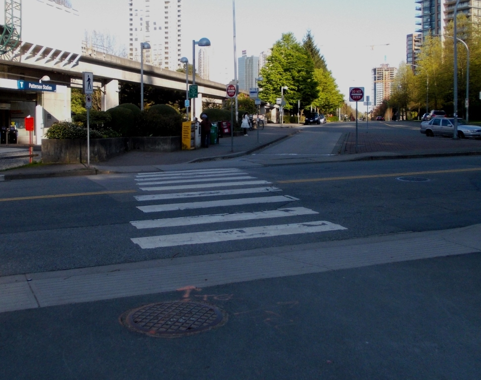
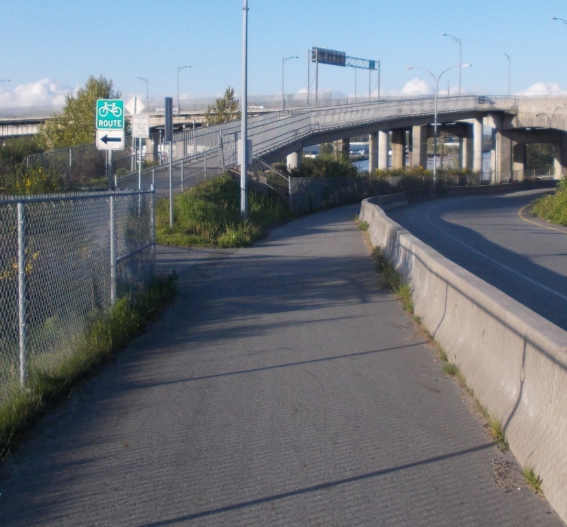
See, bike riding is increasing across the City, as is transit use and just plain old walking to work, while car use is the only mode of transportation in Vancouver that is on a steady decline. The Burrard Street Bridge bike lanes, as successful as they are, were the first time that the idea of dedicating a small percentage of the City’s asphalt to bikes hit the front page. It was, if you will, the first public battle in the imaginary “war on cars”. It also happens to be directly attached to the now-controversial Cornwall-York-Pt.Gray Road bike plan, which is the were the latest battle in the same imaginary war is being fought.

So what better story than a story about how no-one is biking over the Burrard Street Bridge anymore?

Too bad it isn’t true.

“Cherry Picking” is a common rhetorical technique where you take a big body of data, and selectively choose from that data the specific set that makes your point. The best example of this is with the current crop of Climate Change Deniers who say something like “It hasn’t gotten any hotter since 1998”– knowing full well that 1998 was the hottest year in history (well, not really, it is complicated), and ignoring the fact that every year after 1998 was warmer than almost every year before 1998. It is the easiest way to lie with statistics.

So look at the data set that the Province graphed for your benefit, and you see some months were ahead of others (likely related to week-long runs of bad weather that dissuade some riders, but maybe also related to road repairs, Canucks playoffs, whatever little bits of data go into the bigger noise:

It is hard to take from that that data set that cycling is declining, or “stalling”. In this very first level analysis, from two specific time points, on one of the routes measured, there was a 1% reduction in counted cyclists on one route. The model for Cherry Picking data.

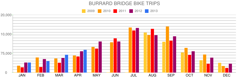
Being the detail-oriented guy I am, I went to the City of Vancouver website and tried to find the data source. The only thing I found was this site, which does actually report cycling traffic counts for the last few years on specific routes. I brought the .pdf  file into Excel and created a chart as close as I could make to the Province one. This proved rather challenging, as their y-axis didn’t make sense- (75,000, 10,000, 20,000 !?!)- and clearly made the raw numbers of cyclists look smaller than they were. Anyway, I used the real numbers, and it looked like this:

Which was subtly different from the numbers reported by the Province. Compare September, October, pretty much any month- the numbers they used are clearly not those from the City’s website.

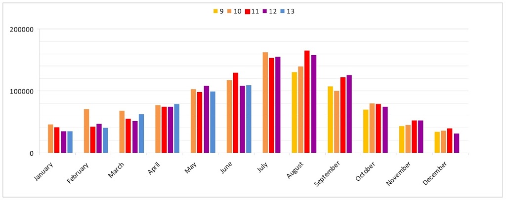
So then I went to Twitter to ask Province what their data source was, and got no reply after 48 hours. What did happen was the Province, a few hours later, changed the chart that had in the online version of the story:

It looked a little more like mine in a few months (January and February), although some months still had bad data (see September). At least they had their y-axis figured out. Progress for the old media.

So let’s ignore their charts, perhaps a mistake was made by an unpaid intern – really, with the Province laying off all of their paid staff, these kinds of things will happen. Let’s look at the actual data.

If you look at the last 12 months for which data are available, there are 7 months when more cyclists used the Burrard than in the same month in the previous year. There were 5 months when there were fewer cyclists. In longer-tern trends, you can pull other things out: January, February and March 2010 were anomalously high – which is clearly an effect of the Olympic traffic disruptions, and not something you can hang a trend on. The June 2011 anomaly can likely be similarly linked to the Canucks Stanley Cup run. My point only that the data is noisy, making Cherry Picking a simple technique.

Looking at the raw data, it is clear that there have been something like 1 million bike trips cross the Burrard Bridge within any 12-month period in the last 4 years. Which makes one wonder how the Province ever found a situation where they could take a picture of the bridge and only have one cyclist in frame.

To quote the article:

“Despite years of Mayor Gregor Robertson and his Vision Vancouver councillors peddling the merits of pedalling, ridership on the controversial Burrard Bridge separated bike lanes has declined in the past year. Total bike trips compiled by the city for the 12 months ending April 2013 — the most recent statistics available — show that ridership is down by 16,000 compared to the previous 12-month period from May 2011 to April 2012.”

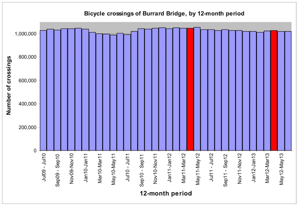
The data tells us May 2012-April 2013 saw 1,028,000 crossings where May 2011 to April 2012 saw 1,044,000 crossings. So the 16,000 reduction is true. But is it relevant? I took the 12-month cumulative ridership ending in every month from July 2012 to June 2013, and here is the trend (the two time periods mentioned in the Province story are highlighted in red):

I’m no expert, but that doesn’t look like a meaningful decline. The number of cyclists crossing the Burrard is basically stable. Meanwhile, the use of bicycles on other routes in the City are increasing. How do I know that? The free toss-away paper I found on the SkyTrain offered a different version of the exact same story on the same day.

Of course, they were also lying, depending on how one reads the statistics.

BLOC – Calling a spade a spade

So I’m on my regular commute home yesterday, and find my bike lane blocked by a parked Tow Truck. It is not all that unusual to have cars parked in bike lanes; there were actually three on my route home yesterday alone.

Most of the time, I just occupy the driving lane (when safe) and mutter under my breath. If the vehicle is a little dusty, I might stop and write “don’t park in bike lanes” with my finger on the back window. Very occasionally, I stop and snap a picture, thinking it might end up on my blog at some point. The Tow Truck was near a “no stopping” sign, and right on top of the bike route decal, and was blocking the entire lane, and I thought – what the hell, I have my camera right here.

As I stop in front of the truck and frame the picture, a guy sitting on the porch of the adjacent house asks me what I’m doing.

“Some asshole parked in the Bike Lane,” I said. “I’m taking a picture”.

He replies, “That’s my truck.”

I turn slowly towards him, shrug my shoulders in a way that I hope imparted the “you called it, not me” impression. Snapped my photo, got on my bike and rode away.

He shouted something after me, I’m not sure what.

It was a good day.

Another uneventful commute

Sorry to not be blogging much, but I have been exceedingly busy with other aspects of life. Mostly enjoying the hell out of summer while getting several things done. Ironically, too much if going on for me to write about all the cool stuff that’s going on. So here is a blog post I just cobbled together from something I wrote around Bike-to-Work-Week, and a recent event, just to hold you over until I have something interesting to say. 

I might have mentioned this before, but I have a pretty good bike commute route to work.

First, the good news. My route is about 21 km long, and (for the most part) flat. I pass through a dizzying array of bicycle infrastructure along the way, and it is (for the most part) well designed and well maintained. I have always suspected this is because my route closely parallels that of another New West resident who is rather… um… outspoken about alternative transportation infrastructure, and who is always willing to call City Hall (be it New West or Richmond) to complain about dangerous or non-functional connections along the route. So thanks, Andrew!

My route to work looks like this on a typical day:

1.4 Km of local city roads with no specific bike infrastructure, but with quiet enough traffic at 7:00am that it isn’t generally a problem;

2.2 Km along the Crosstown Greenway along 7th Ave. This is a traffic-calmed road with limited bike infrastructure (“sharrows” on the road, bike-activated lights at major crossings) and parking on both sides, but mostly benefiting from the traffic calming of the West End neighbourhood.

The 500 m between 20th and the Queensborough bridge are a chaotic mess of pedestrians, passengers being dropped from cars, idling taxis and unpredictable buses, but that is the cost of Transit Station connectivity, and I rarely have “safety” issues here- indeed I use an overly cautious approach to the area being aware of all the unexpected.

1.2 Km crossing the Queensborough Bridge and attached bike/ped infrastructure. This route is super-safe, if a little noisy with the high-speed trucks and traffic so close behind. The sidewalk is a little narrow, which causes cyclists (at least those who aren’t complete jerks) to slow and make way for passing oncoming cyclists or pedestrians, and the surface is sometimes a bit sketchy on those frosty mornings, but no complaints from me!

3.4 Km along Boyd Street (in New West) which becomes Westminster Highway (in Richmond). There is a decent bike lane along the side of most of this route (except for about 1 km of unfortunate ugliness westbound on the Richmond side I have previously pointed out). There is a nasty tendency for large trucks to park in these bike lanes (in contravention of the “no stopping” signs) while grabbing coffee from Tim Horton’s, but this seems a pretty difficult piece of enforcement for the Police, and the City of New West installed break-away barriers to address the issue on Boyd.

2.5 Km along the “old” Westminster Highway. There is no specific bike infrastructure here, and nary a shoulder along most of it, but there is so little traffic along this dusty country road that it is rarely a concern.

1.9 Km along the actual Westminster Highway. This stretch, between the railway crossing and the new lights at No 8 Road is probably the least comfortable part of the whole ride. The shoulder is narrow and dirty, there is currently construction, there is a gentle curve (which often encourages cars to straddle the white line) and the large trucks generally go fast. This part will soon be seeing improvement if the “Economic Action Plan” signs are to be believed, so perhaps there is a plan to improve this spot for cyclists as well.

3.0 Km on a Separated Bike Route adjacent to Westminster Highway. For a stretch of Westminster, there is a 3m-wide separated bike/pedestrian route on the south side of the road. It is a bit “old school” as far as separated bike routes go, and has a few issues- the pavement is in rough shape in a few places, some of the driveways are blind, and the surrounding weeds are making the path narrower in a few places – but it is a pretty good route considering its vintage.

My biggest issue with the route is not a problem so much this time of year, but those damn bollards are going to be the death of me one rainy winter evening. There are dozens of bollards in the middle of the path, presumably to prevent people from driving a car in the bike lane – and the bollards are white with little reflective strips on top. However, at night time (especially in the rain) with headlights of oncoming cars an no other lighting, these bollards are nearly invisible. With the other concerns about the path (in-growing weeds, failing asphalt, and blind driveways), cyclists typically cheat towards the safer middle of the path, but that is where the invisible bollard await…

5.8 Km through increasingly urbanized Richmond: Westminster, Garden City, Granville. All of these roads have decent cycling lanes, well marked and cycling-appropriate controls, so no complaints there. Of course, I often have to deal with the erratic behaviour of Richmond drivers, but that is a whole other post…

But mostly a good ride. Most days.

This Friday something interesting happened, though. I came across a guy riding an electric bike up the Queensborough Bridge pathway as I was coming down. I was apparently exuding attitude, as the pilot first swung his fist at my face while passing, then yelled at me while demonstrating his finger-extension skills.

I stopped and gave him the universal symbol for “WTF?!”, which is kind of a shrug with both upturned hands out front and an incredulous face. This caused him to stop, get off his bike, pull off his motorcycle helmet, and approach me yelling a long string of things about how he had every (expletive)right to (expletive)be on (expletive, expletive) the bike path, and (several expletives on the theme of me not being a very good person). I paraphrase.

Now I hadn’t actually said anything to this fellow, nor had I (knowingly) offered any hand signals or other indications prior to the post-fist-and-finger “WTF!?” gesture, as I was busy riding along the bridge. Perhaps he was irritated that I didn’t immediately pull right over and stop so he could pass me going the other way at 30km/h (likely a more comfortable passing speed for him, on his motorcycle with impact shields and a full-face motorcycle helmet than me with my lycra pants and legally-compliant beer-cooler helmet). Or perhaps he had received so much bad attitude and opinion from cyclists that he is constantly brushing past on bike lanes with his motorcycle. So whatever – I refused to engage, and politely suggested maybe he should just head his way an think about why he is so defensive about things – and move his motorcycle as he was currently blocking the entire pathway and there were two cyclists standing there waiting for him to move it so they could get past.

I had to get out of there quick, as I was in serious risk of laughing out loud, and in his state, that might not have been constructive. But it got me to thinking about this new trend- encountering electric motorcycles on bicycle routes. What’s up with that?

There are two types of electric motorcycles on the roads of BC, according to ICBC, electric scooters and electric-assisted bicycles. The first need to be licensed and insured and you need a drivers licence to use them – they are for all intents and purposes motorcycles. The second are legally bicycles, and require no licencing, insurance and are (apparently) legal on bike paths.

Here are a picture of each, see if you can spot the differences:

That’s right, the first one has little pedals sticking out. There is actually more to it than the pedals: the motor cannot be more than 500W, and the top speed must be limited to 32km/h when you are not pedaling. That isn’t fast enough to win the Tour de France, but it is faster than most casual bicycle riders maintain. The second can be up to 1500W, can pull 70km/h , and you require a licence, a motorcycle helmet, and insurance.

Should these be on bike paths? I have my doubts. They weigh around 200lbs (without a rider), are wider and less agile that a bicycle, and move faster than most cyclists. It seems they ramp up the risk-to-third-persons equation closer to motorcycles than bicycles and pedestrians. If nothing else, they blur the region between human-powered and machine-powered transportation, and the more blurry it gets, the harder it is to think about where to draw lines. Why was the line arbitrarily drawn in 2002 at 500W and 32 km/h?

Alternately, their safe operation (much like bicycles) rely on the responsible behavior of their riders. Just people on bikes need to be extra-courteous to slower users like pedestrians when sharing a multi-use path, users of e-bikes have an extra onus to be courteous to bicyclists and pedestrians.

Something my punchy and profane friend on the Queensbrough wasn’t doing on Friday.

Is there enough shame in being the “Second Worst Road”?

It didn’t start last month. I have lamented the BC Parkway for quite some time.

There was a time, back in the late 1980’s when I lived on Royal Avenue and worked in a warehouse just off Royal Oak, and I would ride my bike along the Parkway to get to work. Back then, it was great – an actual road just for bikes and pedestrians! In hindsight, the connections and some of the route choices were a little sketchy, but that is only with the benefit of hindsight. For ca. 1988, it was a kick-ass bikeway.

Twenty-five years later, I live two blocks from that crappy apartment I shared with my brother on Royal, and the lovely Ms.NWimby has a new job in Downtown Vancouver. A fair-weather bike commuter (the Skytrain ride is only 20 minutes!), we pulled out a bike map and tried to figure the route to her new job for those sunny days when the bike is calling.

We both immediately ignore the BC Parkway and look for alternates: CVG? (stays at low elevation, but seems a long way around New West). Cariboo to Adanac? (nice, but a little out of the way- and killer hill on the way home) Tenth to London to Griffiths to Rumble to Patterson to Moscrop to Smith to 22nd to Slocan to Charles to…(ugh).

Nope, the near-straight line, on a gentle slope (as it used to be a rail grade) that makes the most sense is the BC Parkway. If only it was safe or lived up to its promise. Instead, 28 years of local re-development, new roads, and failing pavement (along with a few original design elements that look hysterically outdated now) have made the route one to avoid for most cyclists.

So now that my little campaign to get the BC Parkway noticed is having its little media push– the whinging has gone as far as it can- so what to do?

First off: Jurisdictions. The BC Parkway is almost completely on TransLink property, and is ostensibly TransLink’s responsibility. Portions of it, however, are clearly on the property of and subject to the decision-making of, the three municipalities through which it passes. Any comprehensive refurbishment will require partnership between TransLink and the Transportation Departments in those Cities.

It’s not like TransLink doesn’t know the Parkway needs help. Back in 2008 there was an assessment report prepared for TransLink. I quote from that report:

Over the years, the dual trail design has proven to be less popular with BC Parkway users while land use adjacent to the trail has intensified, resulting in the paved portion of the BC Parkway becoming a heavily used, mixed-use facility that is generally narrower than the Transportation Association of Canada’s guideline of 4.0 metres for a shared, bi-directional urban path. Intense use of this inadequate facility and lack of proper maintenance has lead to its physical deterioration. The route is indirect in some locations and wayfinding is poor, making navigation difficult, particularly where the route transitions between the off-street pathway and urban streets. Efforts to upgrade sections of the Parkway have resulted in disjointed designs and application of the TAC standards that are not contiguous with other sections of the Parkway.

Yeah, that’s what I said!

Stakeholder meetings and concept plans were drawn up to fix the problems in 2009. Then what happened? Two things come to mind: the Canada Line, and the entire TransLink funding crisis.

The Canada Line Bridge is a great piece of cycling infrastructure (worthy of its own blog post, which I will do at some point soon), but few know it wasn’t actually part of the original Canada Line plan. Canada Line was not, strictly speaking, built by TransLink, but was a PPP dedicated to getting the damn thing in the ground before the Olympics started. The idea of putting a pedestrian-bicycle path on the side of the bridge came from strong lobbying by cycling groups in the City, and concomitant support from Richmond and Vancouver Councils. However, strapping the path to the side of the bridge was not part of the original plan, so the concessionaire building the Canada Line was certainly not going to pay for it, leaving TransLink holding the bag. The only solution was for TransLink to take it out of the bicycle infrastructure budget.

Notably, the cost of attaching the pathway to the Bridge (about $10 Million) was only 0.6% of the Canada Line budget, but represented 200% of TransLink’s annual bicycle infrastructure budget. So for two years, little other bicycle infrastructure got built by TransLink.

After the happy glow from their massive success moving people during the Olympics wore off, TransLink somehow became the whipping boy of the media and most levels of Government – for reasons poorly understood by anyone. I have gone on at length about this in the past, but short version: everyone has decided it is time to stop paying for the transit system at the same time other sources of revenue have been failing (some the fault of TransLink’s own success). The bicycle program budget is alternating between deep cuts and complete defunding. In this financial climate – when TransLink is actually cutting bus service as the region continues to grow – it appears the BC Parkway was simply not high enough on the priority list to see the plans realized.

I recognize I am only pointing out the problem, not what to do about it. I wish I knew.

The first obvious answer is to fund TransLink. There seemed some real promise that this was going to happen before the last election, but the surprise winner seems to think tax collected for Public Transit is the one type of tax that requires a referendum! There is no doubt, based on TransLink’s plans and policies, that they want to have safe, accessible bike routes as part of the integrated regional transportation system, especially ones that connect to their stations and bike lockers. People who ride bikes to SkyTrain stations buy tickets on SkyTrain, the business case is obvious. They just can’t afford to prioritize this right now.

So that leaves the Cities, Vancouver, Burnaby and New West all have budgets for cycling and pedestrian infrastructure, and all are challenged in setting priorities when transfers from senior Governments increasingly come in the form of responsibility, not compensation. For the BC Parkway to be improved, the Cities will need to take them on as a “Pet Project”, and through direct infrastructure spending or finding innovative funding strategies (remember, 7-11 and Molson paid for the first iteration of the Parkway) they will need to come to TransLink with some kind of matching fund. Given an opportunity to “share the cost” will be the only way that TransLink is likely to push this route to the top of the priority list when so strapped for funds.

Ultimately, the BCAA “Worst Roads” campaign is about shaming whomever owns the “Worst Road” (Municipality, Regional Government, or Ministry of Transportation) into in prioritizing the identified roads in their medium-term planning. Note that last year’s #1 finisher also finished first again this year- despite the $19 Million this particular “Pet Project” has recently received. Finisher #3 this year is also in the middle of a multi-million dollar planning process to find what will no doubt be a billion dollar solution. So maybe shame works.

But I don’t want to shame TransLink – I think they know the problem, and they wish they could do something about it. The shame here should go back to the multiple levels of government who have consistently failed to fund alternative transportation programs with the fervour used to provide smooth driving surfaces for cars.

Sufferfest (the photo essay)

Disclaimer: I am much better at riding bikes than I am at taking pictures. And I’m not very good at riding bicycles. Names have been changed to protect the innocent. For background, read this:
Day 1: Vancouver to Whistler begins, as all great Bike Rides should, in the traditional Italian Style- Caffeinated. Note Italian-built Steel bike, Canadian-built Steel Bike, and Italian-built Plastic Bike. We are all about diversity.
The pouring rain of Saturday AM was tempered a bit by a social stop at Porteau Cove campground to enjoy some friendly fire
Flat #1 arrived on the edge of Squamish, where it had (momentarily and mercifully) stopped raining, so as far as these things go, that’s success. Squamish people like their roadside dirt curiously angular. 
Brackendale was time for Coffee #2, courtesy of former co-workers. And it was dry there, which was nice for a day where it almost, but never completely, stopped raining. 
AA demonstrated the appropriate technique for acquiring the 5,000 calories a day we will burn. This apparently included adding chocolate to everything, be it milk or pretzels. 
End of Day 1, with a glass raised and shout-out to Red Van Dan who
could not join us this weekend.
Day 2 saw the addition of various Sufferfest hangers-on of note. Today we ride the Ironman Canada Route.
First stop is the end of the road in the Callaghan Valley. Yes, that tattooed calf belongs to an Ironman Finisher. He put some hurt into us before the day was done. 
Then we had to go a little past the end of the road to see the sights. 
Then it was distressingly downhill to here, where we stopped for lunch. Distressing, of course, because  we knew those hills have an “up” as well. 
The Freight Train really began to roll down the Pemberton Meadow Road. Nothing like 4 guys in formation  pulling 40 km/h for 25km…
…until you run out of pavement, and have to turn that freight train around to face the wind that has been flattering you for 25km. 
Flats #2 and #3 both occurred in one of the most beautiful gas station parking lots in the world. 
Less said about the climb back to Whistler from Pemberton, the better. We dug deep into our panniers of courage, and came back wanting. This is me, unraveled in the bus after, on our way from out lodging to the village and an inevitable one-beer drunk.
Day 3: Back at it. I just realized I was frighteningly close to a bike-matching kit here. With me is the human hummingbird: although a misnomer, as he eats more often, has a shorter attention span, and weighs less than a hummingbird, and has all the aerodynamic qualities of a discarded WalMart grocery bag. Dropped us like bad news on the hills, he did. 
Cheesecake: it isn’t just for breakfast anymore. 
Feeling the pain, here Hummingbird poses in properly menacing from with AA, who was acting all Jens on us – putting the hurt on in the rollers and the flats, churning the air in front of us and forcing hangers-on to contemplate their place in life, until he used the sprint to dash illusions. All the time apparently smuggling cantaloupes in his calf-warmers.  
Although we were well over 400km, the Duffy was not available to us, so we need to put a cap on this thing with a quick spin to the top of the Cypress Mountain Road, where AA entertained with his mad donut skills.
The toll for the weekend: about 470km, 6000m of climbing, three tubes, 15,000 calories each. Untold suffering.   

Sufferfest (part 2)

I wrote a couple of months ago about Sufferfest.

A few buddies and I were going to ride bicycles over a three-legged course through the interior of BC: three days, 500km, two major summits, endless good times good times. And I was going to suffer. And it was this weekend.

Ahh… best laid plans.

Turns out life gets in the way of adult life. One of the riders got called up and is currently sweating or freezing (because, apparently you are never doing neither) in the belly of a LAV somewhere. Another went to start a new business this winter, so (as any small business person can attest) he just doesn’t have a long weekend in the foreseeable future. With the 2/3 of Alberta Contingent of the ride not available, logistics for the interior fell apart.

We ride without a broom wagon, so logistics matter.

One of the riders is planning to Race the Ironman Canada in Whistler this year. I cannot support this idea – in a perfect world no bike ride would ever be immediately preceded by, or immediately followed by, a run or a swim – to do so is to detract from the bike ride. As would wearing a singlet. But each man chooses his path, and there is no doubt his path this weekend will stir up some dust, in which I will be riding.

As the Ironman Canada circuit is new this year, our resident Ironman was interested in pre-riding the course, and from this we developed Sufferfest Plan B.

Saturday we ride our bikes from home to Whistler – 125km, much of it uphill, but a good day in the saddle.

Sunday we ride the Ironman Course – 180km, two out-and-backs, 4200ft of climbing, alles gute.

Monday we will ride back from Whistler – after a quick trip to the Cayoosh Summit on the Duffy Lake road – 230km, switchbacks. This is where we suffer.

Last time I talked about this, I was wondering about my training plan- suffer lots in training, or suffer much more this weekend. I cut the difference, and hopefully have found the calculus. I rode my bike a lot, but have done nothing that could be termed “suffering”. I haven’t done a ride longer than 80km in 6 months. Make no mistake; I will be pedaling squares on Monday.

And this gets real as of tomorrow. I can’t believe Past Pat did this to me.

My Nominee for the Worst Road in BC

MORE UPDATES BELOW (May 22)

Every year, BC’s Car Nobbling Council the BC Automobile Association has a little campaign to shame municipalities into giving more money to the BC Road Builders. This “news” is dutifully lapped up by the popular media, and many fingers are wagged at Cities for not maintaining their infrastructure.

It is good media, good advertising for the BCAA, and after the rush of the contest cools down, AM radio goes back to complaining about high taxes and the evils of socialism. No-one ever mentions that roads are, de facto, a socialist enterprise. Government pooling money from taxpayers and spending it building something for the common good – roads are the very model of socialism. But I digress.

This year, I want to nominate a candidate. There is one route that I have been lamenting for a few years, and it never seems to get the attention it needs. It is 9 kilometres of undulating, root-cracked, potholed, uneven, poorly marked, inconsistent, horribly maintained, and (IMHO) unsafe pavement connecting the New Westminster Quayside boardwalk to Burnaby’s Central Park. It sees a lot of traffic, provides an important arterial corridor connecting numerous other routes, and it has seen little more than a few asphalt patches in 27 years.

Yes, I am talking about the BC Parkway, or to give credit to sponsors from 27 years ago, the combined “John Molson Way” walking path and “7-Eleven Bike Route”.

Let me take you back to the heady days of Expo86. The theme was “World in Motion” and transportation was central to most exhibits. When the SkyTrain was built out to New Westminster to bring Vancouver into the 70’s, transportation-wise, the entire line was paralleled by the BC Parkway. I’m not sure why Molson decided to sponsor a walking path, but for a decade around that time 7-Eleven sponsored a major international cycling team. In fact, the only Canadians to ever wear the Yellow Jersey in the Tour de France did it for Team 7-Eleven: Alex Stieda in 1986 and Steve Bauer in 1990. (Bauer also wore yellow in 1988, riding for Weinmann – La Suisse the year Greg Lemond was busy being shot, but I’m geeking out now). At the time, they also provided me countless post-ride Slurpees. No-one has to convince me of 7-Eleven’s credibility when it comes to support for cycling.

The BC Parkway represented Greater Vancouver’s first multi-community-connecting active transport route – our first “Greenway” that didn’t wrap around Stanley Park – but time has not been good to it.

In the intervening 27 years, the BC Parkway through Burnaby and New Westminster has seen a lot of development. Metrotown, Edmonds, Downtown New Westminster and the Quayside have all blown up since 1986. With all the change, some connections on the BC Parkway have been improved, some have been severed. The pavement has degraded, the crossings have become hazardous, the sight lines destroyed and the route chopped up. The asphalt in place is so bad that tree roots have pushed right through- and are being eroded by bike tires! What other road in the province features tree roots being held back by tires? This is a shameful state for our region’s first real integrated municipality-spanning Greenway!

So, please, I implore you – go to the BCAA website and vote for “BC Parkway, Vancouver ” for being “Unsafe for Cyclists and Pedestrians“. You cannot select it with the map, but enter “BC Parkway” in the search, and if it doesn’t find it, choose the highlighted “following form” text to the left. It takes 30 seconds to use the pull-down menus, and if we enter it enough, they may need to acknowledge us. They have acknowledged us! We are now in the top 10 list of worst roads, so you can enter “BC Parkway” in the search and vote with one push of the button! Tell your friends, tell your neighbours, tell your mom, tell cyclists you see rattling their teeth or getting lost on the BC Parkway, tell pedestrians tired of being treated like pylons on the BC Parkway! If you only vote once this month, do it at the BCAA website!

May 22 UPDATE: You can now Choose “BC Parkway Burnaby” or “BC Parkway Vancouver” – and at this point, I don’t care which you choose, as they are both in the Top 10! All the pictures below are form the Burnaby and New Westminster portion, but applies as well to much of the Vancouver portion. Oh, and the BCAA has subtley changed their marketing around this, to make it apparent that they are OK with a bikeway winning! So get one more vote in – only 3 days to go!

In case you need more convincing, here are some highlights of my tour yesterday from Central Park to New Westminster along the Parkway:

The new parts through Central Park are actually quite pleasant!
First problem at Patterson Station. No traffic controls. Do I dodge pedestrians
on the narrow sidewalk / bus stop / newspaper kiosk, or do I go against
 the Do Not Enter sign through the bus lane? 
Sometimes I’m separated from the sidewalk, sometimes not. What is
a pedestrian to think? 
I guess I could go through the bollards onto the narrow sidewalk to avoid
the pedestrians, but there are signs and bus stops. 
Completely nonsensical intersection, no bicycle controls at all,
high pedestrian traffic, blind approaches. Alas, I dismount.
Hard to get contrast, but this root lump is better than a foot high. 
Yes, tree roots. Yes, they are exposed, and the bark rubbed
off of them by wheels and feet. They have been exposed that long.
Suspension at work. 
Bad pavement, blind intersections, forced to go to the sidewalk,
and unclear way-finding. This picture is the full BC Parkway experience.  
I hope it is legal to ride a bike on the sidewalk in Burnaby, because the
Parkway has completely disappeared.  
Oh! There it is, a few hundred feet down the road. 
I like surfing as much as the next guy, but prefer my waves more watery.
Regular way-finding signs remind you where now-destroyed portions
of the BC Parkway used to be. Memories of EXPO86. 
Interesting fact: much of the Parkway follows the old BC Inter-Urban
electric rail bed. No point removing the tracks, I guess.  
More crumbling pavement…
…and another terrible blind crossing with no accommodation
for bicycles, high traffic, and few options!
Speaking of options, the way-making sign to the right has no
relation whatsoever to the multiple junctions within view. 
There is a sign, there must a Parkway around here somewhere. 
There are my bollards! All I have to do is cross 20th street
with no traffic light, no crosswalk, and terrible visibility. 
This is where the trail takes me in New West – to a narrow sidewalk on the wrong side
of 6th Ave., with no access to the rest of the parkway for several kilometres. 
Insider tip – the Parkway continues on the south side of Stewardson, you just
need to cross the Queensborough Bridge. Please dismount. 
See? Queensborough bridge makes the obvious connection!
(I ranted two years ago about this little way-making fiasco
Unfortunately, the trail over here does not have better pavement…
…or safer crossings.
Our journey ends at Stewardson and Third Ave- where you can choose two roads
with no cycling infrastructure, or an overpass to some unknown place,
there being no way- finding around here. Thanks for joining me! Now go vote! 

Sufferfest

I signed up for a Sufferfest this year. A moment of weakness, a compelling (but probably very bad) idea, a challenge issued, and a handshake agreement. I’m committed.

A friend Andrew and some cycling buddies of his have an annual ritual. They meet up in some Interior BC city on the May Long Weekend, and spend three days riding bicycles long distances over high mountain passes. I saw pictures of last year’s cold and rainy event: it was a Sufferfest.

This year’s plan is no less suffer-worthy, but includes some roads I have never ridden, hence my being compelled to contemplate perhaps taking part. Then the shocking realization came in.

Day 1: (185km) Vernon to Merritt via Kelowna, 97C and the Pennask Summit.
Day 2: (165km) Merritt to Sorrento, via Kamloops, Highway 5 and the Surrey Lake Summit.
Day 3: (140km) Sorrento to Vernon, via Sicamous.

This will be done on bicycles, as fast as possible. Rain or shine, perhaps snow. Suffering encouraged.

The reason I bring this up is that it is creating a lot of discussion among my drinking buddies usual life advisers around techniques to reduce the level of suffering, and much of this discussion is getting very metaphysical. To wit:

Andrew’s advice is to “train”. Aside from the issue of whether I should take any more advice from the guy who got me into this in the first place, the idea of “training” is sort of antithetical to the way I ride bikes. Even in the old days when I used to race bikes, I didn’t train so much as I just went for a lot of long bike rides and more than a few fast bike rides. Intervals? Speed work? Spinning? Not so much. I love to ride, and training was just an excuse to ride more, why reduce the fun of the riding by introducing “training” to the mix? This is perhaps why I generally failed to win races.

I got to thinking, at the meta level, if to train is to suffer, then one has to decide if more suffering is the best approach to reducing suffering. You see, the Sufferfest is going to invoke suffering no matter what I do between then and now. The scale (both depth and breadth) of the suffering will be reduced by filling the intervening time with training, which is programmed lesser suffering to reduce the eventual event suffering.

But how much pre-suffering is necessary to meaningfully reduce the event suffering? Or more important, how does one reduce the net suffering. If one was to graph the suffering over time, you would get something like this:

Since the front part of the curve (training-induced suffering) effects the back part of the curve (Sufferfest suffering), I need some way to reduce the total suffering, which in this case is represented by the shaded area under the curve. I need to find the smallest possible value for that area. That way, I can assure I don’t waste early suffering that will not impact late suffering: I need to find the suffer-minima. I knew I should have paid more attention in college, because this is going to take some intregal calculus.

Then it occurred to me that this may not help me, because the person who has to worry about that is Future Pat. The suffering of Future Pat really shouldn’t be the concern of me, Present Pat. I am already dealing with all the bad decisions made by Past Pat, who not only got me into the terrible shape I am right now by blithely ignoring his bikes for a couple of months, then making some sort of deal with Andrew that has me in my current situation. Past Pat is a real jerk that way, never thinking of others.

This is the same Past Pat, I remind you, who constantly failed to study adequately for calculus exams, dooming Future Pat to marks not befitting the stress induced. I’m afraid he has left me with little choice. Already carrying the load of Past Pat, I’m in no position to be taking yet another Pat under my wing, Future Pat is on his own.

Future Pat is going to suffer the May Long Weekend, the poor bastard. Glad I’m not him.

Bike Ride

I went for a bike ride the other day.

I go for bike rides lots of days, but what made this unique was I decided (against all experience and reason) to go for a bike ride in Coquitlam. Mostly, I wanted to check out progress of cycling connections around the new Port Mann Bridge.

Remember, bicycle and pedestrian access is a “a key goal of the PMH1 Project”, and the plan is to have a bike and pedestrian path crossing at Port Mann for the first time since… well, since anyone remembers. And with all the breathless excitement of the opening of the new bridge (tempered somewhat by the bridge’s sudden violent temper), the introduction of tolls, and New West suffering under the weight of the toll-free alternative, I thought I would pop over to Coquitlam and see what the new bike path looks like.

Except, of course, the new bike path isn’t done yet. And there is no mention anywhere on the PMH1, Gateway, or Ministry of Transportation websites suggesting when or if it will be done. I sent an e-mail to the Gateway people and got this in reply:

A key goal of the PMH1 Project is to improve cycling connections throughout Metro Vancouver, and when the project is complete, cyclists and pedestrians will be able to cross the Port Mann Bridge for the first time.
When the bridge opens in its final design, it will have 10 lanes and one multi-use path on the east side of the new bridge. The multi-use path will have a barrier-separated, three metre-wide cycling and pedestrian path. A portion of the existing bridge must be dismantled to complete the final two lanes on the south approach. Given this, the multi-use path will be complete when the final two lanes are opened. We are in the process of finalizing a schedule, but we anticipate this will occur by the end of 2013.

So cyclists and pedestrians will have to wait another year or so before they get to use the bridge, but it is still a “Key Goal”.

Until then, I can speculate about how useful the bike path will be, considering its connections on the Coquitlam side, and I can lament the abhorrent situation created by the construction of the bridge in the first place. Hence, my little bike ride.

Riding through New Westminster on the Central Valley Greenway is a relatively painless experience. The CVG is not perfect, but it is a pretty good second-generation bike route. Even with a few strange connections on the New West side, it is easy to follow, and at no time is it really unsafe. Trying to connect to Coquitlam, that is when you enter the danger zone.

Dropping down behind Hume Park on the bike path to the Braid Station, the Coquitlam-bound have two options: The Baily Bridge to United Boulevard, or the Brunette Overpass to Lougheed. The second isn’t really an option: it is a confusing jumble of lane-changing highway traffic with no shoulder and an uneven and intermittent sidewalks, leading you to nowhere but more killer intersections. Meanwhile drivers are jockyeying for the hole-shot of the on-ramp merging just before exit or the gap in traffic on Brunette to make the suicide turn off the off-ramp (both definitively not looking for cyclists). I’m an aggressively hyper-aware and experienced bicycle commuter (I worked as a bicycle courier in downtown Vancouver in the late 1980s!), I can move a bike through urban traffic like few people. The Brunette overpass area is too scary for me.

So that leaves us the Bailey Bridge to United Boulevard option. The bridge is ok, wait your turn in the line of traffic and occupy the entire lane so the irate guy behind you cannot pass. United past the Golf Course is currently pretty good, because it was built as a 4-lane but currently has two lanes, so lots of room. It was noted by cycling advocates during the UBE discussions that it is certainly not wide enough for four lanes and a reasonable bike path. TransLink’s inability to commit to widening United to make it a safe bike route was one reason regional cycling advocates lined up against the UBE, even with a bike path on the UBE being a “key goal”.

things get much worse once you get past the new King Edward Overpass (with its luxurious pedestrian and bicycle lanes). United Boulevard is narrow and curvy, just barely wide enough for its four driving lanes. No sidewalks, and certainly no shoulder. Add to this numerous poorly-marked driveway entrances and exits to the commercial and industrial sites and a completely disregarded speed limit, and this is one of the least safe roads for cycling in the region. Yet, there are no alternatives. There are no connecting roads at all to the south. Lougheed is a high-speed high-volume freeway with double-lane turnoffs. Brunette Ave through Maillairdville is only better than United in that there are enough traffic lights to slow traffic a bit. The simple message is that Coquitlam doesn’t want people riding bicycles.

The City of Coquitlam does produce a Bicycle Route map, you can see it here. It is pretty much what you expect, disconnected lines with a few routes, featuring more gaps than actual connections. So once the new bike route accross the Port Mann is built, where is it going to go? Who the hell would ever use it?

According to Gateway plans, it will connect to Lougheed Highway on the north side. This should, at long last, provide the people of Surrey the safe cycling access to Mackin Park they have so long awaited. Or perhaps, they can ride to the King Edward Overpass, and watch 10 lanes of cars vroom by below. Fun for the whole family.

What Coquitlam does have is those kind of bike paths preferred by people who don’t really ride bikes for their utility, but as an alternative to playing tennis or bocce. The short multi-use bike path through the park, where one can drive to and park easily, take the Canadian Tire bikes off the rack, spin around for a half an hour. A great example is the path connecting Maquabeak Park under the old Port Mann to Colony Farm Park (as you can see on the Coquitlam Cycling map). It is not really suited for cycling, is guaranteed to produce user conflict, and doesn’t really go anywhere.

Even this sub-optimal trail has been wrecked by two years of Port Mann construction. With construction staging on top of the old trail, there are signs indicating some sort of detour:

But no actual map or diagram or even arrow to tell you where these detours are. I looked on the City of Coquitlam website, the Gateway one, the MOT and transLink sites after I got home, and I’ll be damned if I can find a map of the purported detour anywhere. so I cannot even blame my complete lack of preparedness for this adventure.

So it was back on United, still bereft of sidewalks or shoulders, but now enhanced by highway on-ramp and off -ramp traffic. Until I was greeted by this:

And this:

I had apparently found the detour. It went right by this spot:

At first, I assumed he sign in the middle was not meant to be ironic. then I thought about it some more, and realized that it was only through the lens of irony or pure David Lynch surrealism that any of the signs made any sense whatsoever.

So what’s the point? When it comes to bicycle access, Coquitlam is a disaster. Combine their incompetence/disinterest with the Ministry of Transportation/Gateway™ aggressive dislike for non-automobile users, and the result is a horror show of pissed away taxpayer money.

The $5 Billion Gateway™ program will, they triumphantly declare, provide “an estimated $50 million in pedestrian and cycling improvements.” Which is, apparently, “the largest single investment in cycling infrastructure in the region”. I would love to be excited about this “investment” in sustainable transportation that represents 1% of the budget, except for two things: It is a sham, and the results will be useless.

The MoT/Gateway™ plan for that $50 million can be read in this report (at least that is the most recent information we have). Aside from including a bike path on the new Port Mann Bridge that won’t connect to anything useful, (at maybe a marginal cost of a couple of million dollars?) it isn’t about building bicycle or pedestrian infrastructure at all. It is about “accommodating” bicycles and pedestrians on the expanded overpasses they have to build to span their shiny new megahighway. Essentially, replacing the current sidewalks and leaving enough shoulder room to paint a white line.

It actually gets worse on the South Fraser Perimeter Road, where the “cycling infrastructure” investment is going to be painted bike symbols on the hard shoulder of a limited-access 80km/h 4-lane truck route. Look at these pictures from the official SFPR website:

See that space between the semi truck going >80km/h and the concrete wall? That’s “bicycle infrastructure” in which they are investing your tax dollars. Looks like a fun place to take the kids for a spin, eh? Why not just call it what it is (pull-off space so stalled vehicles don’t slow the rush of progress traffic), and quit with this shell game accommodation-as-infrastructure bullshit.

If MoT / Gateway™ was really interested in improving cycling infrastructure, they would hand that $50 Million to TransLink or the municipalities to invest in real, useable bicycle infrastructure where it is needed and where it will be used.

In the meantime, I suggest everyone avoid taking bike rides to Coquitlam.