Ask Pat: Arenex Replacement

TM asked—

I understand that an interim structure is going to be built in Queens park as a temporary replacement for the Arenex. Is there any idea how much this new structure will cost and how much money will remain for a future building? As well, will the cost of demolition and 24/7 security monitoring of the old site be deducted from the money received from insurance?

I’m going to be a bit less definitive than usual in answering your questions, because City hasn’t made all of the decisions on this yet.

This would also be a good time to explain to folks that some discussions that take place between the City and suppliers (like insurance companies, building contractors, etc.) may be protected by Section 90 of the Community Charter. Under Provincial Law, there are some types of negotiations that happen between the City and private businesses that are necessarily kept secret so as to not put the City in a poor negotiating situation, expose the City to liability, or undermine the confidence of potential suppliers. The results of these “in-camera” discussions are always made public if and when a decision is made (we cannot spend any money without including it in our publicly-released financial documents, and our procurement processes are always released), but during the negotiations, it is commonly required to keep things under wraps. By Section 90, talking about “in-camera” discussions, even providing some details about what topics were discussed “in-camera“, is illegal until those discussions are raised out of “camera”

With that caveat in mind (whats with all the Latin today?) we did make an announcement back in June (which is around the time you sent in this Ask Pat – yes, I am sorry for not getting to it until now!) that we would fast-track the building of a “temporary” structure to replace the bulk of the Arenex functions, and that building should be operational in the summer of 2018. It will be about twice the size of the Arenex, which should make it a more usable space for some of the gymnastics programs, with some leftover space that may have flexible uses. This building should cost less than the insured replacement value of the Arenex, but at this point, I can’t really provide you exact numbers around this, because I haven’t seen those numbers.

An interesting point coming out of the work staff have been doing is that these “temporary” suspended steel structures have a design life of better than 20 years. They can last significantly longer with maintenance investments. The bigger advantage to us is that the site prep work is simpler than building a new “permanent” structure, and what you may lose in flexibility during the design and procurement stage, you get in efficiency of getting a building on-line. So it is possible that this “temporary” structure will provide gym spaces and other space for decades to come.

The City also went through a bit of a consultation process with stakeholders and an on-line survey back in May to guide us towards permanent solutions. The main questions were around how the Arenex loss should inform our plans for a Canada Games Pool replacement. I think CGP planning after the extensive consultation completed last year is coming along well (I am on the Mayor’s CGP Task Force), and I suspect we will be in a position to make some public announcements about that program before the end of the year. By then, we will have a better understanding about what programming will go where during the CGP/Centennial Community Centre replacement works, and where things will be when the work is completed. A “temporary” Arenex replacement opens up several options to maintain program continuity during the construction phase.

On our last question, I can only speak in generalities, but I have learned quite a bit since this event occurred about how the City insures its major assets. Insured building replacement value (which may or not be the true cost-of-replacement of the structure) is generally separate from other line items related to loss or damage to a building like business interruption,  demolition, contents, engineering reviews, liability, etc. Hence, coverage for security or demolition costs would not be deducted from the replacement cost of the building, just as ICBC would not typically deduct the cost of providing a rental car from your car’s replacement value if your car was stolen.
ASK PAT: Potash

Shaji asks—

This proposal to put a potash storage and transportation facility on the Surrey-side banks of the Fraser river seems absurd!

I have recent made the New West and the Fraser river my home and come to realize how much of it is surrounded with beautiful marshlands and resident wild life – despite the Fraser being a working river. I see seals bobbing their heads out of the water everyday from my window.

Our efforts need to be to preserve and clean up this beautiful surrounding; not further pollute it with such harmful proposed projects.

What is the City’s stance and influence on the proposed project?

Thanks again

The first I heard of a plan to move potash through Fraser Surrey Docks was when a few residents of Queensborough started sending me e-mails. The general theme of these e-mails was “What is the Port trying to pull here!?” Hopefully I can explain, although I have not heard a peep from the Port (officially or informally) about this project, so most everything I know you can read yourself at the Port’s information website about the project.

It appears that one of the world’s largest mining companies, BHP Billiton, wants to build a facility in Surrey to move potash off of train cars and into bulk carrier ships for export. Much like the previous coal terminal facility proposed for Fraser Surrey Docks, this facility will be required to go through the Port’s own Environmental Review process, instead of a Federal Environmental Assessment. This procedure exists because of legislative changes made by Stephen Harper’s Conservative government that decimated the Canadian Environmental Assessment Act – changes Justin Trudeau’s Liberal Government seems in no rush to address despite significant election promises to the effect. But I digress.

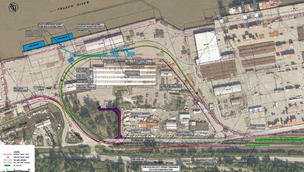
Upon hearing about this proposal, my initial questions were around what it means for the Coal Terminal project. That project has already been approved by the Port, although that approval is still being challenged in court. My cursory look at the proposed coal terminal drawings:

…and the drawings for the proposed potash terminal:

…suggest to me that they do not share operational footprint, except for some rail loop infrastructure. So I am operating under the assumption that potash terminal approval would not mean coal terminal termination. We should be so lucky.

So what do we know about potash? It is mined from evaporate deposits under Saskatchewan; it is mostly potassium chloride with less than 5% sodium chloride and trace amounts of other minerals; it is primarily used for fertilizer, although it is also used in metals refining and other industrial processes. It is no more toxic that table salt, isn’t flammable, isn’t carcinogenic, and isn’t a particularly nasty environmental contaminant in soil or water. There are some well-understood and generally well mitigated environmental impacts from mining. After spending a few hours reading up on potash and its handling, finding science-based sources I consider reliable and relatively unbiased, there is little in my Environmental Geoscientist experience that causes me great concern about this material being handled in or moved through my neighbourhood.

There will be impacts, no doubt. Train traffic, noise, light, and potentially dust (though potash is usually handled though a pretty closed system due it its solubility). The Port review process (as sketchy as it is) should provide us some ability to provide input to the Port about how we want these potential issues mitigated. You can learn about the project and review process by attending an Open House at the Fraser River Discovery Centre on Thursday evening, you can read the project materials here, or you can go to the BHP project site here and provide some feedback directly. For further research, I might reach out to some council colleagues on the North Shore where potash has been handled for years to see what concerns it has caused in their communities.

That said, you asked a specific question, with pretty simple answers: Council has not been formally asked to opine on the project yet (any more than any other stakeholder), haven’t received any reports, and haven’t really discussed it, so the City doesn’t yet have a stance on the project. Our influence as a stakeholder is limited – as we learned from the coal terminal project where our firm opposition did not prevent the project from being approved. I am sure we will participate in the review process, but it would be premature for me to speak on behalf of all of Council on what the City’s position will be.

As an aside, this proposal is apparently to move potash from a new mine outside of Saskatoon, specifically one that BHP Billiton announced they were in no rush to open as recently as August. I have no idea what that means to this project, but the timing does seem strange.

ASK PAT: the Missing Link

Tom asks—

Any news on the BC Parkway’s “missing link” between 5th Ave. and 14th St.? I understand that Southern Railways has given up its lease on the old Central Park Line, and so it’s reverted to BC Hydro and the tracks have been pulled up. Will TransLink be giving this stretch a proper surface any time soon? Can New West nudge them to do it? Or should we hold another “Worst Roads in BC” poll?

The answer to this one is short, but probably unsatisfying, so I’ll do that politics trick of shifting it to something I want to talk about and leave it with asking you another question that somehow makes you forget I didn’t answer your question. Hey, election time is coming up soon, I need practice!

But first, the answer is that it is a work in progress. The City has expressed its interest in making this connection better than it is, and the right of way on the other side of the SkyTrain pillars makes sense. However, complications arise in that the City doesn’t own that land, nor do we own the BC Parkway Trail. I’m not completely up on the details here, so don’t hold me to all of these interactions, but my understanding is that the land belongs to Southern Railway (or BC Hydro), and there are rights of way for TransLink and either Southern Railway or BC Hydro (whichever isn’t the owner). The BC Parkway is a TransLink asset, supported by surface Rights-of-Way, so I think their right-of-way is only for the SkyTrain guideway through that portion, which is why the BC Parkway was not completed through here more than as a sidewalk in the first case back in the 1980’s.

So as far as the rights to build things, including a paved cycling or multi-use path, there is some legal work to do on the part of the City and TransLink. It is in the City’s work plan, but I don’t know when all of the stars will align. I am pretty certain it won’t be this year, possibly next, but I’m not promising yet.

There is another work-in-progress in the same area also in the having-conversations-between-TransLink-and-the-City stage. When Stewardson Ave was re-aligned to build the Queensborough Bridge interchange, a link in the BC Parkway across Stewardson below Grimston Park was lost. There is a route across involving the ramps to the Queensborough Bridge, but it is quite a lengthy detour for West End residents interested in walking down to the Riverfront or Quayside. At one point, a pedestrian overpass below Grimston was proposed, but I’m not sure we should build one, which is where I turn this around and ask you a question.

When is a pedestrian overpass a pedestrian amenity, and when is it an automobile amenity?

This is not an academic question. Our City’s Master Transportation Plan puts a priority on pedestrians, with other active transportation forms and transit next, with automobiles at the bottom of the priority for new infrastructure investment. We still spend an order of magnitude more on maintaining automobile infrastructure than other forms, but when investing in new stuff, our budgets are shifting towards supporting MTP priorities.

So when asked to partner with TransLink to build a new overpass, we need to ask the question: are we building this to serve pedestrians, or are we building this to move car traffic?

The easiest and least expensive way to move pedestrians across a street is a stoplight and crosswalk. This is especially true if we want to assure the infrastructure is as accessible as possible, as any grade separation inevitably results in a compromise between slope and distance, making a simple walk across a road either impossible for those with mobility challenges or unnecessary long and complicated for everyone else. The engineering required to put active transportation users 5m in the air so cars have unfettered free passage below is always counted in the millions.

However, if we build a level crosswalk with lights and buttons and paint, that means cars need to, occasionally, stop and let pedestrians by. It also means that we need to design a crossing to reduce the chances that a driver will fail to stop and kill a pedestrian, which may mean improving sight lines and reducing vehicle speeds in general. When we consider building a pedestrian crossing on this part of Stewardson, will it be the couple-of-hundred-thousand dollar signalized crossing, or the couple-of-million-dollar overpass? If the latter, should we pay for it out of the pedestrian amenity budget, or out of the car amenity budget?

The question may be academic, because it is highly unlikely the City’s engineers or TransLink will sign off on a crosswalk on a City Street that is part of the Major Road Network (as this part of Stewardson is) where the traffic typically moves at 80km/h, despite the 50km/h speed limit. This speed issue is also part of the reason why the existing cycling connection you originally asked about feels unsafe for all users.

And this, multiplied by dozens of places throughout the City, is how we still, for all the best efforts and good intentions, lose our pedestrian spaces to motordom. It is frustratingly slow making this change, it represents a cultural shift in three levels of government and society in general, but that’s our goal.

Ask Pat: The Q’boro edition

Yes, I am a bad blogger. I have Ask Pats in the queue, and run the risk of looking like I just don’t care. But summer is over, which traditionally means time to get back to work, so I’ll try to knock off a couple together here, with a Q’boro theme:

Shaji asks—

Hello Pat
Do you know what is the story behind Frankie G’s Boilerhouse Pub on 305 Ewen Avenue in Queensborough? It seems like it has been under renovations for a long time.

I don’t know much, except that there was a fire, and the owner is doing a major renovation to coincide with the repairs required due to flames/smoke/water. That said, nothing has come across the Council table about it, and I am not aware of any other plans for the site. It is a bit of a shame that they were not open this summer, as it would have made a nice walkable destination during the QtoQ Ferry demonstration, and I know that Port Royal residents are missing having a local community pub. Hope it’s open soon!

Dan asks—

Why did you guys wait so long in the process to figure out building a Q2Q bridge was going to be expensive? How many tens of thousands of dollars did you waste in meetings discussing nonsense with other bureaucrats? You say you have us in your mind, but your thoughts and prayers are piss in the wind. Queensborough is one of the least thought out communities I have had the misfortune of living in. It seems not a single person on the council even thought about basic amenities like a grocery store or how people will get in and out or find parking. You saw a quick way to make cash, promised people a solution and future, and produced nothing. There are thousands of new homes coming up, and little to no forethought into how this will make the already existing problem of access even worse.

To answer your first question, the money to build the proposed Q2Q bridge was not going to be available until around 2015, based on the original timeline of the DAC funding model, when it was put together back in 2007 or so. The higher-priority projects (Queensborough Parks and the Queensborough Community Centre, the MUCF/Anvil Centre) were to be funded and completed first, and were. I wrote a longer piece here about the evolution and challenges of the Q2Q bridge, and a follow-up piece on the decisions made since my time on Council, which may answer some of your questions about how a project originally (in 2008) thought to be in the order of $10Million became a project estimated at $40Million.

I’m not sure how to square the idea that Queensborough is ignored by the City when I look at the Queensborough Community Plan, the investments in the QBB and surrounding parks, the largest road improvement project in the City’s history, and the City investing in childcare and affordable housing initiatives in that neighbourhood as priorities over the rest of the City. Queensborough is growing fast, and the City is investing in making it a livable, working community.

The Community Plan does include the building of neighbourhood-serving retail in a new node near Mercer and Ewen, but the reality is that the City doesn’t build retail developments; that is the job of the private sector. There is a frustrating chicken-and-egg situation where retail developers need to see a large population (=potential customer) base before they will invest and build, but in the meantime, we want local retail to support a growing population (it is kind of like the transit conundrum that sees Port Royal still under-served by Transit as it exceeds the density of many better-served neighbourhoods). The mostly-empty strip mall just over the border in Hamilton is an example of what happens if you try to build small neighbourhood-serving retail in a neighbourhood not ready for it, especially in the shadow of WalMart, but that’s an entire other discussion.

So, yeah, Queensborough is a work in progress, just as every other neighbourhood in the City is. It has an abundance of relatively affordable family-friendly housing options near a bunch of great community amenities, if one is willing to suffer from a lack of retail variety and rush hour traffic challenges. I think the community plan shows some longer-term relief from those challenges, but the solutions aren’t instant, and aren’t for a lack of forethought. Communities often shape themselves, regardless of the best laid plans.

And, as a side note, Council will be doing our annual Meeting in Queensborough on September 11, starting at 6:00pm. If you have a specific Q’boro concern, complaint, kudo or claim, Public Delegations start at 7:00! C’mon out and tell us what you think!

Ask Pat: Q2Q Ferry

I am a little behind on my Ask Pats, I apologize. there are a few in the queue, but work, life, and an amazing array of community events have kept me away from the computer keyboard. I’ll try to catch up.

BoatRidesAreFun asks—

Hi Pat,

Any updates on the Q2Q ferry that was supposed to open July 1? I haven’t seen anything happening at either of the docks.

The ferry has been a challenge. This is one of those times I am glad I am an Elected Type setting unreasonable expectations for staff, and not City Staff trying to meet the unreasonable expectations of the elected types!

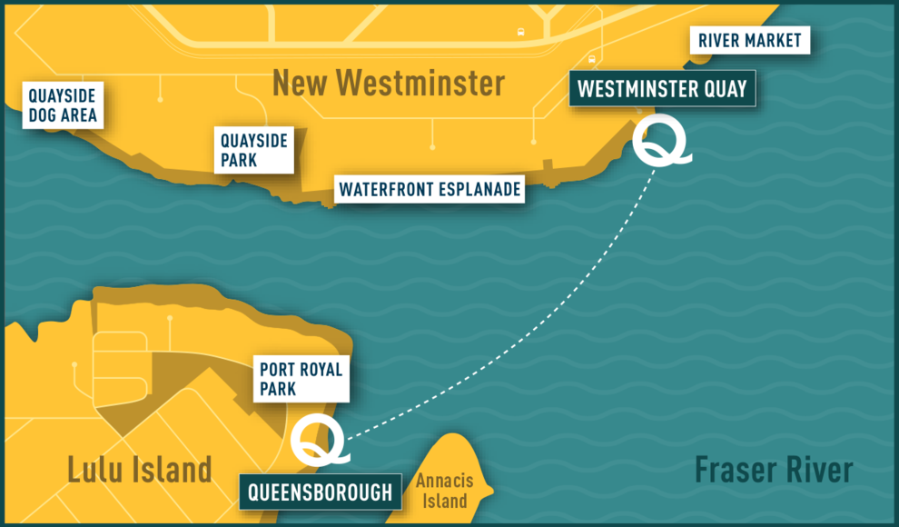
The good news is the the trial is ready to go, and will be starting this weekend. The Ferry will run on weekends and holiday Mondays in August and September from 9:00am to 7:00pm, and from 5:00pm to 9:00pm every Friday in August. It will run every 20 minutes, and will cost a Loonie or a Twoonie. The route will be from the Quay (near the Inn) to the public dock on the south side of Port Royal. The bad news is that the limitations of the project as a “pilot” will mean it falls short of some expectations, and that could benefit from some background explanation, so I am glad you asked.

Running a passenger ferry turns out to be a much more complicated process than you may think. You need a boat and operator, you need (at least) two places for it to dock, and you need permission from several different agencies responsible for keeping people from drowning as a result of poor planning.

The first issue was surprisingly hard to solve. The Fraser River is a dynamic, working waterway. There are tides reaching 9 feet in range, and tidal and river currents that flow in different directions up to 10 knots. These currents shift lots of hazardous debris like large logs. There are also tugs, barges, and large ships moving around the river. The little tubs used to shuffle tourists around the relatively safe tidewater of False Creek were not going to work on the Fraser. Something more skookum (to use the nautical term) was required. The more requirements the City put on a boat (number of passengers, weather protection, accessibility, room for bicycles, operating cost), the more limited the number of available boats just sitting round BC waiting for hire.

Then we need two places to dock the boat. Installing a new dock facility in tidewater in Canada is not a simple process, as it activates everyone from the local Port Authority to the Marine Carriers and environmental agencies including the Department of Fisheries and Oceans. For a short-term trial, the City really needed to find already-existing docks.

Ferry_Map(1)

The public dock at Port Royal was there and available, but designed for small pleasure craft, not to accommodate a passenger ferry. Significant changes would intrude into water lots owned by Port Metro Vancouver, who were helpful and accommodating, but had their own safety and operational concerns that had to be addressed. On the Quay side, the only functional docks are operated by the Inn at the Quay (where the paddlewheeler tours launch from) and the industrial dock operated my Smit. Again, both had challenges with accommodating their established operations with a new every-20-minutes group of passengers, many of whom are not that accustomed to walking around industrial marine operations, and who will create no end of hassles if they fall into the drink and get dragged downstream. Again, a deal was worked out and operational concerns managed.

At this point, City Staff need to be acknowledged for managing a significant number of potential game-stoppers here, but in the compromises required to make this work are the inherent flaws in the final plan. During this summer, we are going to have the trial ferry service that was possible, not necessarily the one we want.

When I think about connecting the Quay to Queensborough, I am not thinking of it as a tourist draw or a piece of recreation programming, I am thinking of it as a vital transportation link. To be such a link, it need to be reliable, available for daily users, and fully accessible. The trial ferry is going to fall short of this. The high tide range and reliance on existing dock infrastructure means it will not be fully accessible to those with some mobility challenges at all tide stages. Running the ferry only on weekends with limited hours means it will not be useful for work commuters wanting to get from Port Royal to Downtown or Skytrain. The limited hours will further cause people crossing the river for diner and a drink to look closely at their watches while waiting for the bill to arrive. The City recognizes these limitations, but also recognizes the value of getting this project running to see how the public reacts.

In the end, I hope people will appreciate this is a test-of-concept trial, and not the ultimate solution to connecting Queensborough to the Quay. Its successes may be limited, but there has already been a lot learned by the City just in setting up the service, and there will be much learned during its limited run, both in it’s success and where it falls short of expectations. I hope that people on both sides of the North Arm will come out to support this pilot, and provide your constructive feedback to the City, so that we have useful info to inform planning for a more permanent solution.

Ask Pat: 22nd St.

W asked—

What are the exact details and status for the increased density rezoning plans around the 22nd St. Skytrain Station?

Funny you should ask that, we just had a Council Workshop where we discussed the Land Use Map around 22nd Street and Connaught Heights. You can read the Report at this link, and follow the conversation at Council on video here.

First off, I need to correct the premise of your question a bit. What the City is doing now is an Official Community Plan update. The OCP is the overarching planning document for the City, which guides how the City develops over the long-term. It will inform how future rezonings are managed, but it is not the same thing as rezoning.  There are a few steps between then and now, which I will outline a bit further down.

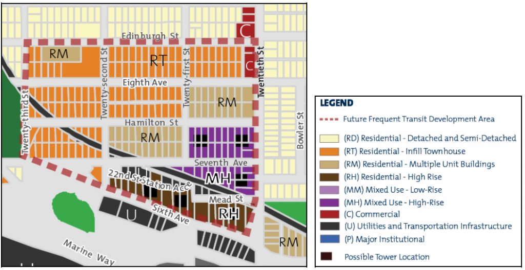
The Council discussion was wide-ranging, although there was a pretty strong consensus on the major components of the Land Use Map, and Council unanimously approved the adoption of “Option 1” for the final Land Use Plan map:

22ndStLandUsePlanOpt1

This option would see up to 6 residential towers build on both sides of 7th Ave between 20th and 22nd, with a commercial node built into the pedestals, and the development of 7th Ave into a true commercial street. There would also be multi-unit residential buildings on two adjacent blocks (think 4-6 story wood frame buildings with underground garages) and a general shift to small townhouse developments south of Edinburgh Street. The townhouses are envisioned to be “infill” type, meaning smaller 6-8 unit townhouse (strata) or rowhome (fee simple) developments that will be designed to blend in with adjacent retained single family homes. This is very different than the neighbourhood-wide large townhouse development style we have seen at Port Royal and around Royal Oak Station.

Included in the Council Report were summaries of the various stages of public consultation, including the most recent discussions with the Connaught Heights neighbourhood about the proposed density increases. There was a wide range of opinions presented, and some significant concerns raised, but none of them specifically surprising. Traffic, green space, community amenities – these are all things that need to be accounted for when we start to contemplate increased density at the west end of the City.

There is also some recognition that previous efforts to bring more density to the area have not been successful. Some of that area has been designated for multi-family since the last OCP was adopted almost two decades ago, and no-one has come in to build that density. This, along with a general lack of housing variety in the Connaught Heights neighbourhood, have resulted in it being the only neighbourhood of New Westminster that had no population growth over the last two censuses. As part of the regional vision of building density around SkyTrain stations and major transportation hubs, this is a place New Westminster is falling short.

The proposal by staff to address the issues raised is to start a Master Planning process for the neighbourhood. This is a high-level but relatively intensive planning process where distribution of housing, transportation, commercial spaces, and amenities are designed based on a set of development principles developed by the community. It is not dissimilar from the process that larger development projects like Victoria Hill and Sapperton Green are designed through collaboration between City Staff and a developer. The only difference in this case is that there is no developer involved yet, so the City and the neighbourhood can work fairly freely to create a set of expectations for future developers to meet.

So “rezoning” and density increases at 22nd Street Station are still a bit of a way off, and there will be some significant neighbourhood consultation before any shovels hit the dirt (starting with a Public Hearing in early Fall to facilitate final approval of the OCP). However, the City will, in passing the OCP and launching this Master Planning process, send a pretty strong message that this density is on its way.

Ask Pat: Medicine Hat

Alice asks—

Is there any reason the Medicine Hat approach of reducing Homelessness in their city can’t be applied to New Westminster? I know it has been said senior gov’t needs to step up but the Medicine Hat strategy involved very little additional funding from senior gov’t. Their population and homeless population appear to be in line with New West.

This is one of the areas of the City’s operations where I have had to climb a pretty steep learning curve. We have Councillors and a Mayor with much more knowledge of this than I do (and some pretty stellar staff, as a bonus), but I’ll take a dive at answering this with that caveat in mind, and keep myself open to correction from those with more knowledge.

Essentially, the Medicine Hat model is based on “housing first” – the idea that if we can first get homeless people into shelter, regardless of how temporary it is, we can get them services they need and start the process of moving them to more permanent and sustainable housing options, and (this is the bigger hope) access to services to help them manage the underlying cause of most homelessness – disabilities, trauma, exploitation, and mental health concerns including addiction. This has been standard operating procedure in New Westminster for a decade or more. So why is Medicine Hat different?

Medicine Hat is a rural community, so it’s 61,000 residents are surrounded by farms and wilderness. New Westminster’s 70,000 people are in the middle of an urban population of 2,500,000 people. New Westminster needs to work along with its neighbours and operate within that reality. That is both an advantage to New Westminster, and a disadvantage.

In Medicine Hat, the most recent homeless count put their numbers at about half the average of the province of Alberta on a per-capita basis. The numbers provided in 2016 news stories estimate there were 875 people moved to supportive housing over the six years of their aggressive program – one for every 70 residents. Extrapolate that to Greater Vancouver, and we would need to facilitate 36,000 supportive housing units in the same period – 6,000 per year. To make this work, the Medicine Hat Community Housing Society received $3.9 million from the province of Alberta (plus about 10% that amount from a combination of the federal and local governments). It is clear the province of Alberta, even during difficult financial times, fulfilled their constitutional responsibility to provide housing. Extrapolate that to the Lower Mainland, and this becomes another boring post about lack of Provincial resources and the terrible priorities of the BC Liberals…

However, there is a persistent problem we have in the Lower Mainland that makes us stand out, and with which “Housing First” is of limited help: the flow of people being forced into homelessness by our out-of-scale housing costs, the erosion of our housing support programs (including the Co-op Housing model), lack of resources for people at risk (aging out of care, coming out of incarceration, or leaving protracted medical care), and our ongoing lack of rental vacancy. To avail oneself of “Housing First” assistance in BC, one first has to be homeless, which is like addressing gun violence by buying bandages: it has a value and is measurably effective, but does not address the source of the problem. This is a terrible way to organize public resources, but more importantly, it completely dehumanizes of the actual problem.

Which brings me back to the Medicine Hat miracle I keep reading about in the news. Considering it is not particularly groundbreaking in approach, and aside from the resources put into it, it’s success is not outstanding compared to many municipalities (including New Westminster), I wonder about the narrative of its success. I do not want to take even the tiniest bit of credit away from the City, the not-for-profits, or programmers (paid and volunteer) who put their lives work into helping less fortunate people, but there is a part this makes me twitchy.

Google any story of the Medicine Hat Homelessness approach, and you hear some version of the same narrative: how the “fiscally conservative” Mayor was convinced to support the program, because it turns out paying to put people in housing saves the City and the Province money in the long run. Now, this is true; so well established it isn’t even a point of debate, but quotes likes this fire my cynicism gland:

“It makes financial sense. That’s how I had my epiphany and was converted. You can actually save money by giving somebody some dignity and giving them a place to live.” – Mayor Clugston

The fact that a leader describes his decision to provide basic human dignity to marginalized residents of his community in terms of its ability to turn fiscal profit is abhorrent to the way I view governance and society. Maybe he is just saying that to keep the Randian libertarians in his town off of his ass, or perhaps it speaks deeply of the state of western Canadian politics and the erosive influence of Calgary School neo-liberal fiscal policy projected by “Think Tanks” like the Fraser Institute on governments at all levels… I’m about to go on a long rant here, so perhaps I will save that for a future blog post… but this economically-driven “come-to-Jesus moment” narrative sound more like cowardice than visionary leadership to me.

Short version is we, in New Westminster, are regional leaders in providing housing support to our homeless residents, and I will hold our success up against Medicine Hat’s any day (not that this is a contest – when it comes to supporting marginalized populations in this country, we are all losing). New West is forging partnerships with senior governments and investing in supportive housing, and we are providing City lands to develop innovative housing solutions. We have incredible staff and NWPD liaisons partnering with an amazing suite of not-for-profit agencies to address the multiple causes of (and solutions to) homelessness at a person-to-person level. We did this before it was sexy, and perhaps we don’t brag enough about it. More importantly, I would like to think we do it not becasue of some fiscal bottom line calculation, but because homeless people in New Westminster are citizens of New Westminster, who deserve representation for their elected officials, and should have the same access to support, dignity, and opportunity as everyone else.

Ask Pat: Taxes – the western suburbs edition

westvandude asks—

I read your property tax comparison article as I was looking to compare West Vancouver to City of Vancouver taxes. For instance if we say what is the total tax paid on a $2.5 or $3 million house in either community (so property tax, garbage, sewer, water, etc) as I always thought City of Vancouver was more expensive…. when you compare Vancouver streets potholes and snow removal it seems Vancouverites are getting ripped off. Where would I find a comparison for total taxes for same value houses?

Hey, wait, this isn’t a New West question! It also sounds like you want me to answer one of those questions that a few minutes on Google could answer. That link I just used is a little old, but fresher information is pretty easy to find. For example:

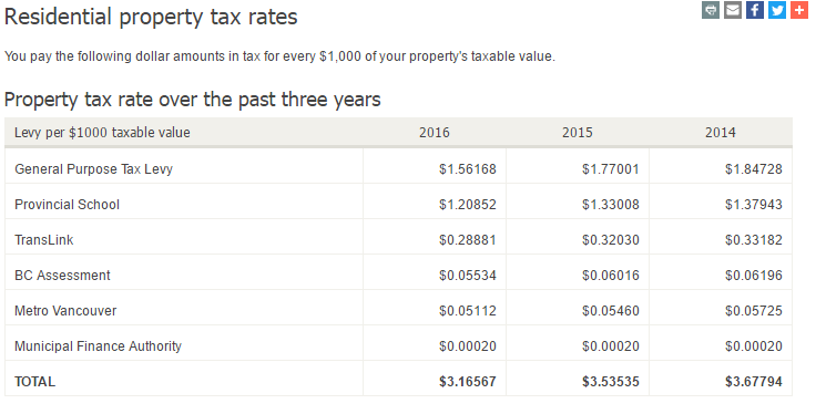
Go to the City of Vancouver Property Taxes webpage, and it gives you a pretty good summary of what your Mil Rates are, and where they go:

taxes1

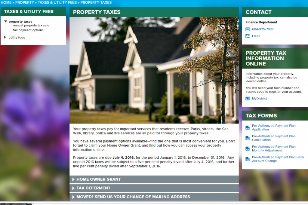
Unfortunately, no such page exists that I can find on the West Vancouver property taxes webpage.

taxes2

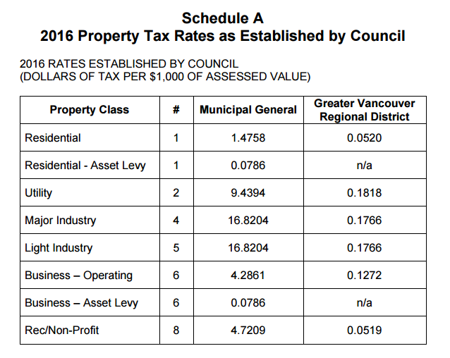
To find the Mil Rates, you need to dig a bit through the Bylaws until you come upon Bylaw No. 4885, 2016, where the Mil Rates Rates are set out:

taxes3

If we can ignore Metro, School, and other property taxes that don’t go to the City and are set provincially or regionally, on a house assessed at $2.5 Million in 2016, you paid $3,700 to West Vancouver (2.5M/1,000 x 1.4758), and $3,900 to Vancouver (2.5/1,000 x 1.56168). Of course, we also have to, just for a moment, put aside the absurdity of the phrase “$2.5 Million house in West Vancouver”.

Utilities are more complicated. West Van charges Quarterly for water and sewer. Water has a $60/qtr base charge, and rates that go from $1.15 to $1.93 per cubic metre of water depending on how much you use. Sewerage further costs you $32/qtr plus another $2 per cubic metre of water you use.

Vancouver bills for water on a Ternary basis, with about a $31 base charge, and rates that go from $0.95 to $1.20 per cubic metre of water based on season. Sewage costs a further $0.87 per cubic metre of water use. So it sure looks like for most users, Vancouver water rates are quite a bit lower, but it depends completely on your use. If you have typical household use, Vancouver is several hundred dollars cheaper per year.

Notably, West Vancouver charges homeowners a “Drainage Levy”, which is $400 per year for a typical home. Vancouver does not have a charge like this. That extra $400 charge easily exceeds the difference in property taxes between the Cities. And also points out how the deeper you dig into the comparisons between how different cities pay for their public services, you discover that simply saying “Vancouver has higher taxes than West Vancouver” is a bit of a meaningless phrase. This is why I tried to compare what cities collect in taxes per capita, using data normalized a bit by the provincial government. West Van looks pretty expensive when you look at it that way.

Finally, about the roads and pothole thing, you can look at the 2016 West Van budget, and see they have about $100M in revenue every year, and spend about $4.5M on all engineering services (about 2/3 of that spent on roads). Vancouver’s 2016 Budget showed $1,260 Million in revenue and spending of about $75 Million in all engineering services – so about a 33% higher proportion of revenues. Of course, the roads that Vancouver spends money fixing are way more likely to be used regularly by a West Vancouver resident than vice versa. Also note that Vancouver has (almost) the most roads by area and the most road lane kilometres per capita than any City in British Columbia, where West Vancouver has relatively sparse roads. So we are, once again, comparing apples to pineapples here.

New West taxes? We are about average per-household in the region, and are well below average on a per-capita basis. And the potholes this year are terrible, despite the $4.5 Million spent on asphalt annually. That December snow event was pretty hard on asphalt, and that is going to cost us.

Ask Pat: $1 Transit?

Terran asked—

Hey Pat,
Hope I’m allowed to still ask questions even though I don’t live in New Westminster anymore. (I’ll be back once affordability comes back)

Translink recently started asking about transit fares again. This was a long time promise for the compass card that we could better manage the system. The survey is quite overly simplistic but that’s not my question more concern.

My question stems for the comments below the Facebook post they have for the survey. The idea of $1 transit fares comes up. Considering only ~35% of the budget comes from transit fares could this actually be a realistic option? I know I would switch from using my car if I could get to work for only a $1. Would the increased ridership even come close to off setting the huge loss in revenue? Is there even a way to know?

Sure, I’ll give you one free question since you used to live in New West. Wait – was that your question?

As you mention (and I talked about a bit a few weeks ago), TransLink is going through a Fare Review process right now. This is likely in response to the integration of the Compass Card as much as to a newfound opportunity for the next stage of system growth, as the Mayor’s Plan for a decade of capital investment may be back on track.

This review is not intended to boost or reduce fare revenues, only to re-jig the system to make it work better; to make it more “fair” or more user-friendly. The working model is that any adjustment would result in about the same revenue from fares, it will just be collected in different ways. The survey therefore was designed to collect people’s feelings about fare structures such as whether people who travel farther should pay more, or the entire system should be a flat fee, but is basically silent on what the actual flat fee or distance charge would be.

What you are suggesting is not just a “flat fee” model, but one that sets the fee quite a bit lower than it is now, in hopes that it will boost ridership. Considering the purpose of the survey, what would that rate have to be?

TransLink receives a little more than 1/3 of its operating revenue from the farebox, or about $510 Million of a $1.4 Billion budget. Aside from roads and bridges and all the other things TranLink does, they annually have about 240 Million journeys on the multi-modal transit system, or 360 million boardings (obviously, some portion of journeys results in more than one boarding, as a person may transfer from SeaBus to the SkyTrain, or from one bus to another on a single journey). So depending on whether you want to issue transfers or not, you would need to charge $2.15 per journey, or $1.45 per boarding.

So a dollar won’t be enough, but would this simple and cheap fare boost ridership enough to make up for it? At current service levels, there would need to be a doubling in the number of journeys on the system, or a 45% increase in boardings. Anyone riding a SkyTrain during rush hour or standing on a 106 recognizes this is not viable without a significant increase in service levels, which would require investments in the capital part of operations (buying more trains and buses), not just increased operational costs.

Perhaps there is some wiggle room in the idea of flat $2 fares per journey, one might speculate that this would provide a 7% increase in ridership to make up for the lost revenue per ride, but that brings us back to the fairness question: should a person riding the 106 from Columbia Street to Uptown pay the same amount as someone riding SkyTrain from Surrey to Downtown Vancouver? Which type of journey are we trying to incentivize more? These are the questions the current review is trying to address, even at a relatively simple level.

Calculating an optimum fare, one that incentivizes use but also provides enough ridership to maintain a system, is some difficult calculus, even putting aside the political implications of increasing the various tax subsidies to the system (or the massive tax subsidies to the alternatives). I don’t think we are going to get there through this fare system review.

And seriously, we really need to talk about how much you are spending on your car now. If $1 fares would sway you, perhaps you might want to crunch the numbers and see where $2.15 fares put you, financially. The sad reality is that, regardless of how much we subsidize cars, they are still surprisingly expensive to operate if you do the actual math.

Ask Pat: Rapid fire

Wingate asks—

So my condo went up 31 percent so i can expect another increase over and above the percentage increase council votes approved? My net taxes went up 18 percent couple years ago in 1 year. Can you tell me the projected loss for the Anvil centre this year? Also how much last year? When will I be able to pick up copy this years budget at city hall. I did read some good news recently, Ford is going to make hybrid Ford Explorer police vehicle in 2019, so our police can enjoy the comfort and safety of a large SUV and the tax payer can save money on fuel. (Is the propane the city is using exempt from the translink tax on gasoline, hence the savings in fuel)

I hope people will use that Ask Pat button up there to the right to get a little more feedback on how the City works, or to answer a question that is grinding at them. My goal is to help people feel more engaged in New Westminster, and at the same time provide me some content ideas for the blog. I haven’t really been able to keep up with them as they arrive, and there are still a few the queue, so let’s see if I can get through this one quickly.

Question 1: Yes, becasue the City-wide average increase was about 28.5%, so you should expect your taxes to increase 2.5% plus whatever increase Council votes upon. See details here.

Question 2: No. See more details here.

Question 3: No. ibid.

Question 4: Not sure if they print paper copies anymore, but our 5-year Financial Plan for 2017-2021 was officially passed on March 6, and should be available on our Financial Reporting webpage.

Question 5: I don’t think that is a question.

(Question 6: Yes. The Gas Tax collected by the province to to fund Translink operations is only charged on gasoline and diesel)