Ask Pat: Omnibus edition!

I had a few Ask Pat questions in the queue, and it being Family Day Long Weekend and all, I figured I would answer them all in one fell swoop. Have a question about the City, Council, Politics, music or fashion? Hit the red button up there to the right and send it to me, and more likely than not will answer it, hopefully before you forgot you even asked it!

RK asked—

I was in Winnipeg this last Christmas for a few days, and when I visited the public market at The Forks, I saw they had craft beer/wine stall set up in the main food court area, where people could buy a drink (served in glassware) and then enjoy it at any of the tables in the market, not just a roped-off area. Are you aware if there are legal restrictions on such a business opening in the River Market? It seems like a great and space-efficient way to not only add more life to a market but also complement the existing food-service businesses. And perhaps it was just the time of day that I was there, but I didn’t notice any roaming gangs of drunkards smashing up the place or terrorizing young children.

I’m not one to speak for the River Market. They are a private business with a business model that works for them. They have been pretty successful at activating the Market Hall, and I have enjoyed many, many events there over the last few years. It is also one of our community’s great “Third Spaces” where you never know who you will meet or the conversation you are going to have when you get there.

I also may not be completely up to date on the changes to BC liquor laws as they pertain to public spaces, but I think the Market would probably be able to license the common spaces as you suggest. However, this would very likely limit their flexibility in how they operate the space, and strange things like security measures and temporary license suspensions to accommodate special events would probably be more hassle than it is worth. The owners and operators of the Market are pretty entrepreneurial and creative, so the best evidence I have that the inherent hassles make it not worth doing is the fact they are currently not doing it.

That said, have you been to Fridays on Front? There was even a Christmas Edition under the Parkade this year. There were shifts in provincial liquor laws that allowed this to happen, and it took a bit of vision to put New West at the leading edge of activating those changes. I think the Downtown BIA (with some support from the City) has done a great job demonstrating that public market spaces can have an open license for adult beverages available without chaos ensuing. I’m old enough to remember the craziness that used to come with public drinking in BC in decades past, and the cost of managing that craziness made some great events go away (I’m looking at you Seafest Vancouver Seafest, Pentiction Peachfest, White Rock Sandcastle festival). I think the attitude around beer and wine have changed as our society has matured, though the transition away from puritan prohibition-era liquor controls is a slow one.

And as of the leading edge of current regulation, there are no special event licenses envisioned for cannabis, but I’ll hold that conversation off for a future post.


JJ asks—

are you the person that sides with justin trudeau of political correctness? Jaywalking the word to be remove? Stop the left wing removement!

[Sic] Dude, if you think Justin Trudeau represents some sort of left wing of Canadian politics, we are not conversing from the same frame of reference. My disappointment in his election in 2015 was very much tempered by the knowledge that Harper was headed for a long-overdue trip to the political wilderness, but I was also disappointed that Mulcair decided to tack towards the centre and got “out lefted” by Trudeau on the campaign trail (though that was not the only NDP campaign mistake last election). Clearly people were ready to move left politically, and voted for progressive ideas like legalization of cannabis (done), electoral reform (shamefully abandoned), and feminism (the jury is out on this one). Predictably, Trudeau swung right after the election and abandoned many of the most left-progressive ideas upon which he campaigned, from climate action to reconciliation, and his record is almost indistinguishable from Harper’s Conservatives on these files. Gord Downie would be disappointed. I am becoming less and less of a Trudeau fan as time goes on, and look forward to calling him out on his failures in October, but I will not make the mistake of looking for him to my left.


FB asked—

If i find someone isn’t sorting garbage and i take a picture as proof is it violating his personal information or privacy?

I’m not a lawyer, and know better than to give legal advice. If you have a problem with how someone is managing their waste stream , and suspect that they are contaminating the recycleables or compostables, there is good reason for you to take action, because this type of contamination costs the City money, or your Strata potentially lots of money, depending on how your waste is managed. I might suggest that friendly attempts at education might get you further than surreptitious incrimination. They may just not know better, as the rules for waste sorting are sometimes complicated and constantly shifting.

If this is going into the City’s waste stream, you can contact our Engineering Operations folks at 604-526-4691 or engops@newwestcity.ca. If you are in a Strata or a rental, please let your building manager know and ask them to take action. It is their job, and they will save money in the long run if they have a well-organized waste stream that assures as much waste as possible is diverted from the landfill.


Jenni asks—

How do I find out information about previous renovations done to my home before I purchased it? The previous owner simply said that all of the work was done before they purchased the home. Is there an archive of building or renovation permits that I can search?

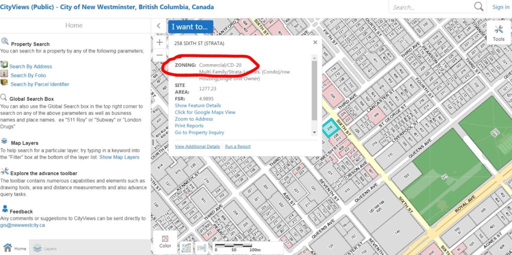
Hey, I actually know the answer to this one! The City has an online tool where you can search for all kind of details about the property you own, or snoop on your neighbor if that is more your thing, because permits are public information, and the City has a pretty open approach to sharing data that belongs to the public.

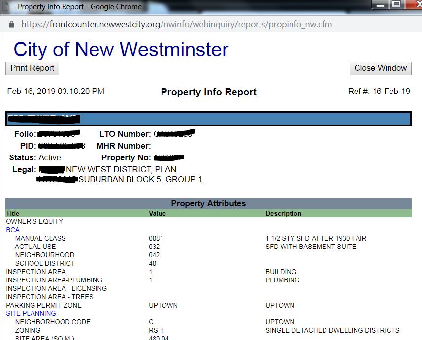
If you go to the City’s website, and look for “Property Inquiry” under the Online Tools section, you get a slightly-ugly but super-functional interface that allows you to get an online report that tells you all sorts of info about your property. For the fun of it, I searched for my house and found a bounty of info about my lot size, the amount of tax I pay, and even that the Business License for my consulting hussle is up to date (redacted a bit to make it one step harder for stalkers to find out where I live):

You can also get a list of all the permits for the property:
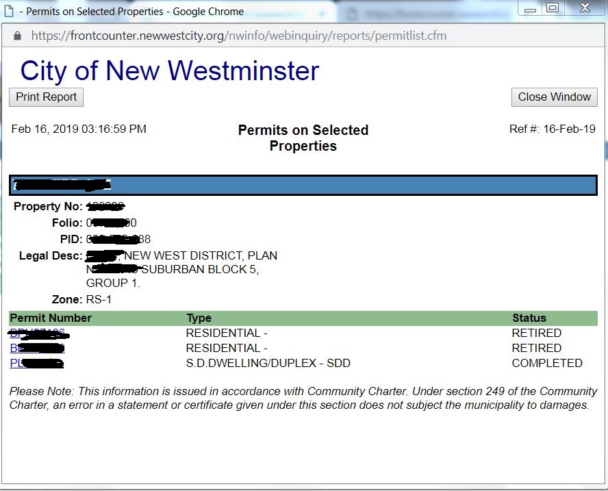
Here I can see three permit numbers: the original building permit was from 1940, my rear sundeck was built in 1987 with a valid permit, and I can see the permit I took out for my bathroom renovation project I did two years ago.

Of course, there are no permits there for the renovation of my basement that probably happened in the 1980s, or of the attic conversion that happened around the same time, or of the transition my house clearly went from knob-and-tube electrical to modern insulated wiring. It is possible that permits were not required, or the owner at the time didn’t get a permit, or the City has lost the records. This just to say that the City knows what the City knows, and you should not assume the data you get from these searches is a definitive record of the work done in your house.

Ask Pat: Protecting Trees

Someone asked—

I’m curious about the tree protection bylaw that was introduced a few years back. The amount of protection barriers around the city is quite high and frankly questionable. The city of New Westminster neither supplies the materials to build these barriers, nor do they facilitate the recycling of either wood or barrier fencing. In fact, the orange barrier fencing is not recyclable at any Metro Vancouver transfer stations. How have we come to having to contribute substantial, single use construction waste, both plastic and wood, to landfills in order to protect trees that in many cases are not in harms way. I challenge someone to accurately estimate the amount of waste we are creating. We are cutting down trees, so we can build a barrier around another tree and then throwing the wood away . It’s all a bit of a head scratcher imo.

Yep, that is a good point.

First off, let’s go over how we got here. New West adopted an Urban Forest Management Strategy back in 2016. At the time, the City’s tree canopy was measured to be about 18% of landcover and trending downwards. The City set a goal to increase this cover to the North American average of 27% over 20 years. To do that, we need to do two things: Stop cutting down so many trees (during a time when we are densifying our neighbourhoods!) and plant more trees. The Tree Protection Bylaw is primarily about the former, but if well administered will also help with the latter.

When the City introduced the Tree Protection Bylaw, we did so building on the existing Bylaws that exist around the region. Why re-invent the wheel when other nearby communities have already taken a test drive? This allowed us to get out of the gate quicker, but also resulted in a few parts of the Bylaw that didn’t really work so well in our local context, so we have been making some changes to the Bylaw as we go along, and have made some adjustments in how it is implemented. This happened in a context where (frankly) not all of Council was on board agreeing that a Bylaw was needed, or felt that the protection provisions were too strict. I don’t agree with that position, because I think trees are fundamentally important to the livability of our community – the more the better – and the cost of protecting them is easily offset by the cost benefit to the community.

One of the aspects common to most tree protection bylaws is tree protection fences at construction sites. The idea is that a fixed temporary fence line to protect the branches and critical root zones of protected trees when construction happens around them. This is to stop the occasional (usual accidental) bumping over of a tree by an excavator, or the excavation of tree roots required for the tree to remain healthy. Sometimes they are located away from any visible excavation work, however this is likely because they are located in a location identified as a likely laydown area for building supplies or fill or drive alleys for construction vehicles – loading critical root zones can be almost as damaging as excavating them.

These fences – staked-in lumber with polypropylene safety fencing – is pretty typical of these bylaws. It uses materials typical to construction sites (i.e. doesn’t introduce something builders aren’t used to) and are relatively durable and cheap to put together. They do, admittedly, look a little overkill in some applications, but they are definitely on the cheap & easy solution side of things.

However, you do point out rightly that they seem pretty wasteful. Most scrap lumber at construction sites is kept out of the standard waste stream, it is commonly “recycled” into wood products used to fire turbines and generate steam or electricity. The polypropylene, however, seems destined to the landfill. I’m not sure it is a substantial proportion of construction waste for a typical project, but there is no reason for us to add more.

I have had a preliminary discussion with city staff about this to understand the need a little more, but will follow up to see if there has been any effort to explore alternatives. I suspect temporary modular fencing might be much more expensive (so we will get backlash from builders already irritated by the need for tree protection), or if the City can suggest alternative materials, or even provide at a cost-recovery rate recyclable materials that meet the needs of the Bylaw, the industry, and homeowners. Thanks for the idea.

ASK PAT: a two-for-one

Bill asks—

I enjoyed the Bikes on the SFPR piece. Riding over the Alex Fraser is treacherous – the deck is slick in parts and the guard rail is not high enough to prevent you going over the edge if you fell off your bike – what can I do to influence change?

The Alex Fraser was a pretty cutting-edge piece of cycling infrastructure when it was built in the 1980s, now it is a sorry excuse for cycling access. With the Canada Line Bridge, the Port Mann, and the recently-refurbished Ironworkers Bridge, the remaining pieces of terrible infrastructure like the Pattullo, Knight, and Alex Fraser really stand out.

It was unique back in the 90s for having well-graded entrances and a uniquely grippy surface. It was almost enough to make us ignore the too-low barriers and narrowness, made worse by the occasional road sign pole in the middle of the path. Now the surface is worn so there are slippery parts, and the access paths at the Delta end are disconnected and disintegrating from neglect.

The bridge belongs to the BC Ministry of Transportation and Infrastructure, so that is the place to go to raise concern. I would start by contacting your MLAs office with a respectful letter. It is timely, as there is currently a $70 Million project to expand car capacity on the bridge, and the same ministry is currently touting their new Cycling Infrastructure Program. I think the work recently completed at the Ironworkers is a great example of how a smart intervention into existing infrastructure can make the bridge safer for all users.

However, one voice is never as powerful as collected voices. If you really want to help cycling infrastructure not just in your neighbourhood but across the region, you should think about connecting with the two “All-Powerful Bike Lobby” groups in the Lower Mainland. I am a member and regular donor to HUB, who are great on-the-ground cycling advocates, with local chapters in every community in the Lower Mainland. The BC Cycling Coalition is a more of a coalition of local groups (including HUB) that do more provincial-level lobbying. Both organizations do great work, and are excellent resources for cycling advocacy info. If you want to push the needle forward on cycling infrastructure in the region, join one of both, and help them raise our voices.

In the meantime, keep the rubber side down!


Nicholas asked—

Hey Pat, I was just wondering if you knew what was happening with the old Commercial/Occidental Hotel on Columbia, across from the Westminster Block. Hoping theres some rehabilitation in the works!

No idea. It is a 120-year-old registered heritage building that has been under renovation for as long as I can remember now. There seems to be some slow progress on restoration based on my anecdotal observations, but I do not recall anything coming to City Council regarding the property in my time on Council. There is nothing shown in the City’s “Projects on the Go” listing for that property, and there are no applications for the property that I can see on the City’s public GIS. So your guess is as good as mine.

Ask Pat: 660 Quayside

Back from vacation, refreshed and ready to rock 2019, and no better start than banging off a couple of Ask Pats!

Jeff asks—

How long will the Waterfront detour at 660 Quayside be in place? For the entire duration of the build or are they getting the Waterfront walkway done before the full project gets underway? More importantly, where could I find this information? I see a lot of info online regarding the 660 Quayside project, but nothing about the required closures / detours.

The project at 660 Quayside, known as Pier West, is going to be a big, disruptive construction project. There is no way around that. Everything I write below is based on my current understanding of the project plan, but need to add the caveat that any construction project at this scale will no doubt see some changes and adjustments as they go along. The reality is that there will be a variety of factors (ground conditions, the regional building market, unknown unknowns, etc.) that will impact any timelines being proposed so early in the process. And quite often a lone City Councillor is the last to find out about things like this.

What I do know is that the developer agreed to delay the start of the project and adjust their construction staging to better accommodate the needs of the community, both by delaying the closing of their existing parking lot until the River Sky project has an operating public parking lot, and by adjusting how they do their major dig so that the inevitable closure of the railway crossing at Begbie Street is as short as possible.

There is some good news here. When this project is complete, it is going to be transformative for our Riverfront. What is now a pretty scrubby parking lot will become a newly-designed and better working Quayside Drive, two residential buildings and a daycare/commercial building, a completed waterfront boardwalk/esplanade connecting Pier Park to the River Market, 2 acres of new public greenspace expanding Pier Park to the west, and a new accessible pedestrian/cyclist overpass from the Parkade at 6th Street over to the expanded park. There will be a few surface parking spots around the base of the new buildings, but the bulk of the parking will be below grade (including something like 80 public parking spots), assuring that views of the Riverfront from Front Street and the intersections at Columbia are improved over now – we have avoided a big above-ground parking pedestal that can overwhelm public spaces. I think the project is going to be a great addition to the City’s Riverfront.

Between then and now, however, the entire 3.5 acre site is going to need to be excavated. Dug up, fill and contaminated soil removed, shored and sealed, and underground parking and mechanical spaces built. There is no way around the need to build a “bathtub” to accommodate the new landscape and underground parking. To make the situation worse, a big section of Quayside Drive that connect the River Market area to Begbie Street does not belong to the City (it has belonged to the owners of 660 Quayside for as long as anyone can remember, with the City has operated the road on a right-of-way). That area is going to be dug up to re-align the streets and build access to underground public parking. There no way to do this that isn’t disruptive, but the disruption will result in a great Riverfront improvement.

With that background, we can get to the essence of your question. The agreement the City has with the developer is that access to the west end of the existing Pier Park needs to be maintained. Until the Sixth Street overpass is built, that means that some form of pedestrian walkway needs to be maintained from Begbie Street. As installing sheet piles secant piles along the waterfront is an early part of the project, the access is not likely to be along the waterfront, but through the parking lot as it is now. Once the overpass is built and the bigger dig begins, you will need to cross at the Begbie intersection, go along Front or Columbia Street to access the Pier Park via the new overpass. How long this type of diversion will be in place is not an answer I have for you right now, but expect it to be for more than a year.

Secant piles being installed today. These are going to keep the underground garage and the river from interacting.

I suspect as the project moves along I will be able to give some better answers to some of these questions. Right now, the buildings are approved as far as zoning, and they have a partial building permit for the shoring and piling work currently happening (you can track this kind of stuff on the City’s “Projects on the Go” page) but a lot of the other details around the construction are still being worked out. Any kind of work like this that includes the River will trigger a bunch of Federal and Provincial environmental hoops for the builders to get over, work on the overpass and intersection means the Railways are going to be involved, and of course there will be legal agreements around rights of way and access relating to the redesign of the Begbie Street and Quayside Drive intersection. The developer has, up to now, shown a great deal of patience and willingness to work with the community (including the River Market, who are being impacted the most here), and I think that, in recognition of the high level of disruption this project may cause, Council will have reason to be kept more aware of progress than with a typical building project.

I don’t have a site contact yet, but once the project begins in earnest, I expect that there will be a person at the construction company who will be able to answer inquiries from the public. In the meantime, best to send specific requests to our planning department at the City (follow this link for the contact info)

Ask Pat: Setbacks

“Jean-Luc” asks

I live in a new condo building that abuts right onto an older building. I’m not sure how the developer got away with building right to the property line. Needless to say, the owners of the other building were not happy with us, and really, it’s not what we envisioned either. What is the minimum distance requirement between two multi-family dwellings…if any?

It depends. And unfortunately, the better answer is buried in a complex and arcane document called the Zoning Bylaw. The Bylaw was originally adopted back in 2001, but has been significantly modified such that the latest version consolidated to include all changes up to July, 2018 are cobbled together into not a single pdf, but a website that links to a relatively well-organized list of several pdfs that you can access here:

https://www.newwestcity.ca/zoning-bylaw

In there you will find a 9-page list of amendments, in case you care to see the evolution of the Bylaw over 17 years. You will also find an introductory document that lays out the format of the Bylaw, including 22 pages of definitions and the names of the 75 “districts” into which the City is divided, each with their own specific rules. Telling, but not surprising if you have ever been to a Public Hearing about a rezoning, this launches off with then 22 pages of parking requirements, before a bunch of seemingly-random but no-doubt-logical-at-the-time rules about things like garbage and recycling storage facilities and satellite dishes… alas.

There is also a little bit in this section about setbacks – the required distance behind a property line where buildings can be constructed, but here it is a strange list of specific spots that were probably put in place for location-specific requirements like utility offsets or traffic sightlines. If you want to know how close you can build to your property line or how close your neighbour can build to it, you probably need to get into the specifics of the zoning district that applies.

To do that, you go to the Zoning Map (sorry, you probably need Silverlight to do that, because it is 2018), and see what zoning district applies to the spot of land you care about. Just open the map, zoom/scroll to your location and click the property, a table with zoning on it should pop up (I circled in red):

Then you need to go to the comprehensive list (7 documents, 400+ pages) of zoning districts to see what the specific rules are. All this to say, there is no single rule, but a set of rules and local exemptions apply, so everything I say here is general and the only relation it has to your specific case is that it almost certainly doesn’t apply to your specific case. Zoning is complicated.

In generality, for single family homes the “side setback” is 10% of the lot width or 5 feet, whichever is less, but never less than 4 feet, although it may be possible for some non-wall to “project” into this setback in special cases. That not clear, but about the clearest case you can have.

Condo buildings vary in their zoning type, depending on what type of building they are (townhouse or small apartment building or tower?). Some fit snugly in a Townhouse or Commercial District designation, others are “Comprehensive Development Districts”, which are stand-alone zoning rules developed to support a specific development at a specific site – and therefore have an address attached to them. The nearest one to where I am sitting now is the one I clicked on in the map above, which is CD-20: Comprehensive Development District (246 Sixth Street). This was put together in 2008 to permit a 16 storey residential tower with commercial “live-work units” at grade, now called 258 Sixth Street, just to complicate matters. It has no set-back requirement at grade, but setbacks above 9.14 metres (i.e. starting on the fourth floor) of 2.5m at the streetscape sides (to reduce the “mass” of the building as it appears from the street), 14.2m at the rear and 7.1m on the neighboring-building side (both to reduce the proximity to current and potential future residential buildings).

When you look at the building you can see that the lower part of the side was build, as most commercial buildings are, to butt up against a future adjacent building, while the upper parts are built to provide a bit of space between future residential areas:

The reality is that the fixed rules are more commonly treated as strong “guidelines” based on best practices. For example, the general practice for towers is to have more than 30m between the “towery” parts of towers, and in commercial areas the best practice is to have no space between buildings at grade in order to create a cohesive, attractive, and safe commercial frontage, where gaps don’t make any planning sense (like this spot I recognized recently in downtown Port Coquitlam but failed to take a photo of, so thanks Google Street View):

Every Comprehensive Development District has its own character, as does each neighbourhood. Its shape and form of any planned building is impacted by the buildings that are adjacent to it and by the future vision of the neighbourhood based on longer-term planning guidelines like the Official Community Plan. However, all of these guidelines can be overruled by bringing a Development Plan and appropriate Zoning Amendment to Council and convincing Council there is a good reason to vary from the guidelines. Sometimes this means placing a tower towards one side of the pedestal in order to reduce the viewscape conflict with an adjacent building, sometimes it means the increasing the size of a setback in order to provide some community benefit like improved pedestrian realm or emergency vehicle access. These are the complicated maths that often require months or years of negotiation between our planning staff, the landowner, stakeholders and the community.

Perhaps that is the part of the entire development-approving process that most of the public don’t understand when they see a project come to Council for a Public Hearing. They see Council approving or denying a specific building, but in actuality it is a large and complicated stack of compromises (by than landowner and the City) and potential benefits built up over those negotiations that Council eventually is asked to approve or not approve.

So your building may have allowed zero setback as part of its zoning, or a zero setback may have been something the City wanted as part of the development to create a more amiable streetscape in the long term, or a zero setback may have been something the developer of your building wanted to maximize the amount of square footage they could sell. Likely at least two of these are true, or else it would not have been built like that.

Ask Pat: Smoke and edibles.

DB asked—

The bylaw regarding Cannabis Regulations No. 8043, 2018 has a section saying retail shops cannot sell edible cannabis. I live in an apartment in New West that has a strict no smoking/vaping policy (which I am very happy about). Edible Cannabis is a work around for situations like mine – unless it will be legal to smoke on the streets (which I am assuming is not the case). I understand it has been adopted but, I still wanted to voice my opinion on it.

That was not strictly in the form of a question. But I’ll take a stab at it.

We are one day away from the legalization if cannabis in Canada, and all three levels of government have been scrambling to get a regulatory regime together. It is a challenge – this an unprecedented change in the regulation of a psychotropic drug. From a local government side, we needed to put together zoning and business bylaws to support the operation of the stores that coincide with the model that the province put together. We also have to think about the inevitable nuisance complaints we are going to receive around the legalization of what is, for all its alleged benefits or harms, a pretty stinky substance.

On edibles, our Bylaw is designed to parallel the federal regulations. There will be no legal edibles sold in Canada in 2018. I suspect this is related to a myriad of packaging and labeling concerns, and addressing the risk to children when sweets and drinks are made containing the psychoactive elements found in cannabis. There is some suggestion that they will address this in 2019, but until then, dried product intended for smoking is the only legal form of recreational cannabis.

Your point about Strata rules prohibiting the smoking of cannabis is definitely a concern. With the existing prohibitions around public smoking – no smoking in parks, in bus stops, 7.5m from the door to any public building, or inside any business or public building – you are right that there will be limited places where it is legal to smoke cannabis. Unlike alcohol, you will not be able to go to a business (like a pub or coffee shop) to smoke, but you will be able (as best I can tell) to smoke on the sidewalk or the street, as long as you are not within 7.5m of a door or air intake. Still, if you are restricted from smoking at home because of strata or rental rules, your opportunities are really limited. This creates a fundamental unfairness – this completely legal product will be inaccessible to some.

I honestly don’t know how to address this and remain compliant with the various laws at all three levels of government. If you have the skills, I suppose you could bake your own edibles using the dried product meant for smoking (I don’t think that would strictly be illegal, as long as you don’t sell the baked goods). Or you can wait until the federal government gets the edibles part figured out. The transition to this new regime is going to be challenging for several reasons.

As a city, we tried our best to put together a comprehensive set of regulations. We had a few workshops with Council and staff, and heard from the public and stakeholders in the industry. After some pretty challenging debates around what the limits should be, we settled on what will no doubt be an imperfect regime, but we will learn as we go along. We will be ready to accept applications for cannabis retailers as soon as legalization occurs on Wednesday, but as the process to get a store approved and operating may still take several months, don’t expect to be buying cannabis in New West until early in 2019.

Update: Time between the legalization of cannabis and the first e-mail complaint received by Mayor and Council abut having to smell the smoke in a public place: 16 hours.  

Ask Pat: Dark Fibre

Jenni asks—

Will the dark fibre network also be connected to older buildings or just new builds?

Short answer is yes, the BridgeNet fibre network can be connected to old buildings and to new builds.

The City of New Westminster is investing in a so-called “dark fibre” network. Hardly as ominous as it sounds, this means we are installing conduits in the ground under our roads, and are putting optical fibre in those conduits. We are not putting light through that fibre (hence the “dark” moniker), but are leasing the rights to light up the fibre to Internet Service Companies (ISPs). We invest in putting fibre in the ground, they pay us to use it. They then sell you (be you a resident or a business) the data connections that are made available. I wrote a little more about it a couple of years ago here. 

The end result for residents and businesses in New Westminster is that they can go to one of the (now 7) ISPs who are leasing BridgeNet fibre and get higher speed internet service than the Big Telecoms are willing to offer in New Westminster. This increase in competition also means your internet (and TV and phone) service may be offered by these ISPs at more competitive rates. Faster internet for less money: that is the goal.

Of course, there are devils in details. We are currently still installing fibre, and it will be a few years yet until all of the major development corridors throughout the city are connected. The “last yard” gap between the fibre and your computer mean that it is multi-unit buildings where the ISPs are concentrating their energy right now in getting hooked up. We have also been working with ISPs to provide specific boutique services to different business sectors, such as higher-cost service to tech businesses that need a really big pipe to move a lot of data, and are willing to pay for it.

There are currently no plans that I am aware of to bring fibre from the BridgeNet Network to single detached home neighbourhoods. The economics are just not there for the ISPs to make that service viable, though there are some interesting delivery models around line-of-sight over-the-air delivery that may make the datarate/cost calculations work out for tat type of service eventually. However, there is nothing preventing older multi-unit buildings from working with one or more of the ISPs to put a junction box in their telecom room, and making the service from that ISP available to their residents or business owners.

Again, the Cit’y role here is to provide the fibre to ISPs and charge them for its use, when it comes to providing retail service, you are best to contact the ISPs directly (or through your Strata Council or Building Management Company).

Ask Pat: Two projects

In the spirit of getting caught up, Here are two Ask Pats with similar answers: “I don’t know”.

mmmmm beer. asks—

I appreciate the transparency your blog offers. I just have a quick question. What ever happened to the Craft Beer Market that was supposed to go in at the New West Station. Is that still moving forward?

Shaji asks—

Firstly, thank you for getting back to me on my question about Frankie G’s ????
Secondly, there are many of us residents at the Peninsula and Port Royal in general wanting to inquire about the plans for the Eastern Neighbourhood Node. I know there were some extensive discussions and planning sessions between the City and Platform Properties. We also have noticed that some ground preparation work has started. Any updates that you can share on what work has started, what are the prospects and what are the timelines for this project. Thanks ????

Yes, the answer to both of these questions is “I don’t know”.

The Craft Beer Market was a proposal that came to Council for a Development Permit back in July of 2016, and was proposed for the empty lot across from the Anvil Centre at Eighth and Columbia. You can read the report starting on page 348 here. It was brought to Council as a Report for Information, and the next steps were to be Design Panel review and some public consultation, then staff would bring a Development Permit bylaw to us for approval or rejection. I remember the conversation about the proposal being generally positive (see the Minutes of that meeting, Page 13 here), but we have not, in my recollection, seen any further reports.

The Eastern Neighborhood Node that would connect Port Royal to the rest of Queensborough with a mix of residential and commercial property has been the subject of several meetings. The most exciting part of the proposal (and the part that led to some discussions around the layout of the site ans stage of development) was the allocation of some 50,000 square feet of neighbourhood-serving commercial. This would bring (it is hoped) a small grocery store a some basic services to the booming Port Royal community. There would be some land assembly required, as (again, to the best of my knowledge), the developer does not own all of the land required to make the development work, and some pretty significant utility and drainage engineering needs to be done to support the development.

Both of these speak to how complicated development can sometimes be, and to the fact that Council is not directly involved in some of what makes development happen or not happen in the community. We can, obviously, say “no” to a development proposal that requires variances or zoning changes, but once we say “yes” to a development we really can’t force the developer to build. Even the “yes” we give a developer does not typically contain a timeline to completion. As plans are developed, construction costs are calculated, compromises are negotiated, and market forces are navigated, sometimes the math ends up not working out for the proposal we see at Council, and it never happens. Commonly, those things occur in a way that Council would never see. If there is no decision for us to make, no plan or change of plans for us to approve, we are most likely in the dark about the details of what is holding the situation up.

Both of those proposals have some very public-facing companies involved. They may be able to answer your questions better than I can. As a general principle, I think getting retail happening on the eastern end of Queensborough and that empty lot at Eighth and Columbia activated would be great things for the City, and for our residents. I don’t know how I can make either happen faster than the landowner plans to invest. I can tell you that there is no action that I know of that Council has taken to slow down either proposal.

Ask Pat: Bent Court

I have been tardy on Ask Pats. I have this other project going on, and have taken the Ask Pat thing analogue a bit to reach more people. However, there are a few in the queue here, and I am going to spend a bit of my Thanksgiving weekend trying to get caught up. Enjoy!

Chris asked—

Hello,

In an archived memo back in 2016 you posted this regarding the future study of Bent Court.

Bent Court: This area is interesting, a mixed residential and commercial district that is zoned for high-rises, although it is unlikely that anyone would build to that scale here. Staff is recommending a special approach here that can incentivize the preservation of the heritage homes, whether they be used for residential or commercial.

Can you help clarify why it is unlikely that ” anyone would build to that scale here”

Bent Court is a bit of an anomaly. The comment you hearken back to was part of the OCP discussions, where we recognized a few areas in the city that didn’t fit into a bigger area-wide picture very well. The West End and Massey Victory Heights are pretty internally homogeneous, but areas like Lower Twelfth Street and Bent Court are not easily defined, nor is it clear what land use will be most successful there.

Bent Court is mostly a collection of heritage-aged houses, many of them converted to some sort of commercial use. They are immediately adjacent to the uptown commercial area, but also serve as a buffer to the residential areas of Brow of the Hill. There is currently one project being (slowly) built on this site where a heritage house is bring preserved and a 6-story residential building is being built. Even they project caused us some challenges, as determining what a full compliment of parking should be for an area like this that is walkable, but not that close to SkyTrain is a difficult estimate. Street parking can sometimes be at a premium, but many of the apartment buildings nearby have largely underutilized parking. Alas… parking…

My thought in that statement about building to full high-density at Bent Court (in C-3 Zoning, this means Floor Space Ratio of over 5, mixed-use commercial at grade, residential above) was my own feeling that the economics and difficulty of assembling land to make it happen make it unlikely in the current market. Each of the lots is worth more than $1 Million now, to build to the scale of the adjacent mixed-use towers, one would have to assemble a dozen properties. Some (or most) of these properties have some potential heritage value (which adds some uncertainty to the approval process), and are currently returning commercial lease rates that make them economically viable as they are.

That said, there is a lot of development going on right now across the region, and I am not a land economist, so I may not be reading the market well. Not long after I wrote that statement, a real estate company put signs up suggesting land assembly and high rise development are viable options. That doesn’t mean it is going to happen, nor has there been an application for any kind of rezoning or development permit arrive at Council, nor is it clear how staff, Council, or the community would approach such an application. A Bent Court Area Study is planned for 2019 as part of the ongoing OCP Implementation Plan, and this will provide a little more robust economic analysis than my speculations above. Stay tuned, because there will no doubt be opportunities for community input at that time.

I could imagine Bent Court as a pretty special place. Co-op ownership, preserve the heritage houses, convert them to live/work units where artists can set up studio space and live on their studios, add a few food and drink opportunities and some clever marketing, and it could become a unique mini-artisan village of regional importance. However, one doesn’t have to be a land economist to recognize at a million dollars a lot, it would be neigh impossible to make this work unless one had small fortune to dig into… any patrons out there?

ASK PAT: Small trees and Beg Buttons

neil21 asks—

Howdy. Two questions having just moved here from Vancouver’s West End.

1. Why are the street trees so short? Is it just time (but I thought this city was older) or the species? The streets are really hot without that shade.

2. At 6th and Carnarvon, pedestrians don’t get to cross without pressing the button. Even if pedestrians are crossing the same way on the other side.
2b. Also why aren’t your beg buttons those buttonless ones like you have for the bikes? Those are better.
2c. Also why does 6th and C have beg buttons at all? Just let peds cross with green cars always.

Welcome to New West. I would love to hear more about your decision to move here from our western suburb, and your experiences since making the shift. The theme of my answers to the above will be “A City is always a work in progress”. We are now headed the right direction, but have more work to do.

1: (caveat: I’m not an arbourist, but I have a couple of suppositions) First, the trees may be younger than you are used to. The City of New Westminster, with the exception of Queens Park (the neighbourhood) and a few parts of Glenbrooke North and Sapperton, really lost the plot on street trees a few decades ago. It may have been the fashion of the time, the cost of development, a mandate by the electrical utility, or just short-term thinking, but our urban forest was cut back in a devastating way. Our canopy cover City-wide is less than 18%, which is similar to Vancouver, but low compared to much of North America. It was only a few years ago when New Westminster introduced a new Urban Forest Management Strategy, and started to a) proactively protect the trees we have; and b) ramp up plans to plant trees and bring back more canopy cover. Unfortunately, the ultimate results of this will not be seen for another decade or two. That said, although the best time to plant a tree is 20 years ago, the second best time is today, and we are getting on it.

That said, it is also possible that trees are smaller above ground because they are smaller underground. Trees need healthy root systems to prosper, and our 150-year-old streets and sidewalks and utility corridors mean that the area of healthy nutrient-rich and porous soil around many of our newer trees is limited. This may mean staff decided to plant diminutive tree species to respect the available growing area, or it may be that the lack of soil is keeping the tree from meeting its ultimate size. There is a bunch of new engineering practice around creating “soil cells” as part of new street tree installations, but see last paragraph about 20 years.

2: (Mostly) because the City is old, doesn’t have endless money, and until recently, it wasn’t a priority.

Beg Buttons (the pejorative name given by pedestrian advocates to buttons that must be pushed by pedestrians in order for the red hand to become the white man at light-controlled intersections when the cars get a green light) were all the rage at one time, because everybody important drove, and pedestrians were just another thing that needed to be managed within car spaces to get traffic moving.

Our new Master Transportation Plan, however, prioritizes pedestrians for the first time, so we are working on changing these things. That said, Beg Buttons can still serve a purpose for system-wide traffic management in more pedestrian-oriented urban areas. They can assure that crossing times for wider roads are adequate for slower pedestrians when they are present, and not too long when they are not. They also make the audible crossing signal for the hearing impaired work better. As always, the devil is in the details.

In some places, we still have older Beg Buttons (even old-style small-button ones in place of the larger panel-type ones) in places where more modern treatments would be appropriate. These are being replaced as budgets allow on a priority basis. Every year, Transportation staff do a review of all  identified crossing improvement needs, place some draft priorities on them based on safety, potential to dovetail with bigger projects or adjacent development, and other factors. They pass that priority list through the Advisory Committee for Transit, Bicycles and Pedestrians, the Access Ability Advisory Committee, and the Neighbourhood Transportation Advisory Committee, then spend their budget making the changes. Sometimes that means curb bulges, marked cross walks, lighting changes or updating the signal operations. All of these things are ridiculously expensive, hence the need to set priorities.

In some places, the Beg Buttons will remain (although I hope we will eventually migrate all to the more accessible panel-type ones) because they are a useful tool. If well applied, they make crossing safer for pedestrians, especially in lower-pedestrian-traffic areas. However, when they are not well applied (as you point out a 6th and Carnarvon, and I can point out a few more in the City), they create an impression to pedestrians that are not a priority in our public spaces, and sometimes go so far as to create inconvenient barriers to pedestrians. Perhaps a good example is all of the crossings along Columbia Street in Downtown, where there is an almost constant east-west flow of pedestrians, and pedestrians should see the white walking guy every time cars get a green light.