I have a bunch of queued up ASK PATS. Sorry, folks, some have been here for quite a while. Things have been busy, and priorities at Council have been shifting so fast and furiously that I have let these linger. I am going to try to clear the queue here in the next little bit. So the answers may be shorter than usual. But probably not, because I like to go on about things…
Don asks—
NWSS safe biking routes need some help. One of those problems is the car traffic cutting through the gas station at 6th and 8th. Perhaps if barriers were installed on the double yellow lines on both those streets would improve safety and traffic flow. Is this possible?
Maybe. That is a pretty “operational” question, and I frankly don’t know the technical requirements when it comes to installing mid-road barriers. I suspect come of those flexi-posts would reduce the number of illegal turns here, but I have also seen drivers do some pretty bizarre things to get around them. Jerks gotta jerk. As this is a more technical operational question than a Council Policy one, you may want to enter it to SeeClickFix or drop a line to Engineering Ops and see what transportation staff say.
As for bike routes to NWSS, we are working on it. The building of the new High School has given us an opportunity to review how cycling and pedestrian connections to the High School work. With the “main entrance” for the School shifting form 8th Street to 6th Street, there will definitely be a shift in how students get to the school:
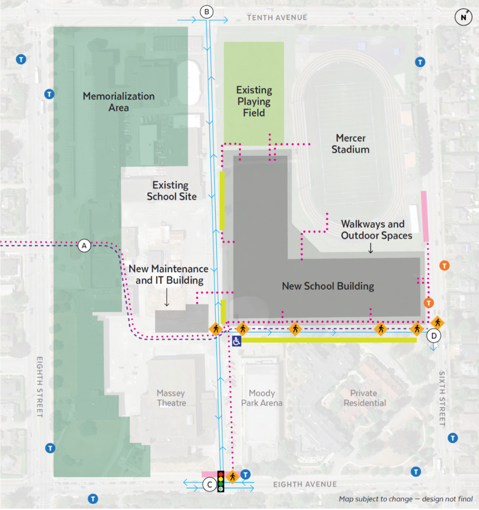
The City has worked with the School Board and project delivery team on this. The first priority is assuring safe and accessible pedestrian access a the two main “entry points”which will be mid-block on Eighth Ave (“C”) and mid-block on Sixth Street (“D”). The pathway across Eighth Street through the existing school site (“A”) is also identified as important, but will be addressed in the future as the demolition of the existing school and design of the memorialization area will delay works on that side. Light-controlled intersections, crosswalks, and sidewalk upgrades are planned at “C” and “D”.
The City is also committed to assuring there is a safe separated cycling route from Seventh Ave (part of the Crosstown Greenway) to the school. By the time the School opens, that will be a separated path along Eighth Street to Eighth Ave, a new intersection treatment at Eighth and Eighth, and improvements of the pathway past the Massey Theatre.
The Connection of the Crosstown Greenway to the Sixth Street entrance to the school property is going to be designed and implemented as part of the Uptown Streetscape Vision, which will redesign all of Sixth Street from Fourth Ave to Tenth Ave. This is currently going through some stakeholder engagement, but is a bigger road redesign project that will not be implemented by the time the School opens.
Thank you for the follow up. I really appreciate the information provided and the fact you and city hall have our safety in mind as we move ahead with street redesign and a new school to opening.
I’m curious what the route is from Massey Heights? Kids are having trouble with the bus but I can’t think of a safe bike route that doesn’t require a going a bit or quite a bit out of the way. My only suggestion is a bike route straight down 8th Ave. I can picture a bike path going in on 8th between Park creative and 5th Ave. I suggest eliminating parking on one side of the street to do this. It would also improve safety as many cars and buses cross the centre line on the section to avoid hitting cars parked on the street. Or they could just increase the bus service to every 15 minutes between 8-9 and 3-4