This isn’t exactly an Ask Pat, but I was asked a question on Facebook comments thread discussing the new Crosstown Greenway changes along 7th Ave, and I needed more than a Facebook post to answer:

I read two questions here, tied up into one. Paraphrased, the first is “How many cyclist injuries or deaths are there in the City to justify all of this money spent on bike lanes?”, and the second, perhaps more nuanced, is “What data justifies spending money on all these new bike lanes”.
I didn’t answer the first question, because I think it is a terrible question, but never got around to explaining why I feel that way. If we have a spike in deaths or injuries, it may be an indication that we have a problem that needs immediate attention, but we don’t wait for those spike if we can anticipate and prevent incidents. A raw count of deaths or injuries as the sole driver of infrastructure investment is not responsible governance.
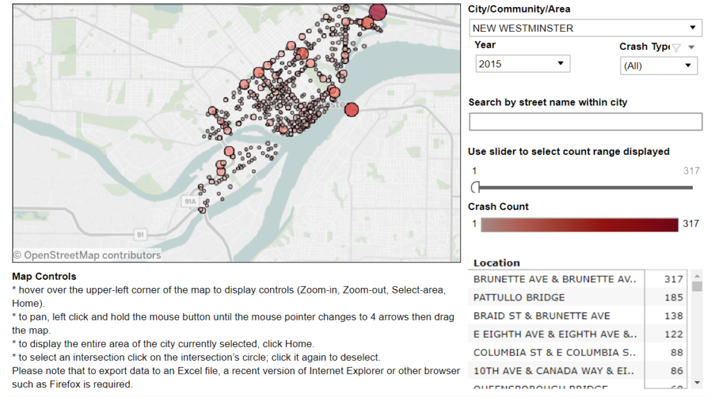
The actual data being asked for is hard to come by. Local governments do not (to the best of my knowledge) collect these stats in any kind of comprehensive way for public consumption. ICBC presumably still collects stats, but their reporting out has become pretty inconsistent, and their crash maps for New Westminster have not been updated since 2013 (for Pedestrians and cyclists) or 2015 (for cars) and cannot be filtered by injury/death/property damage: 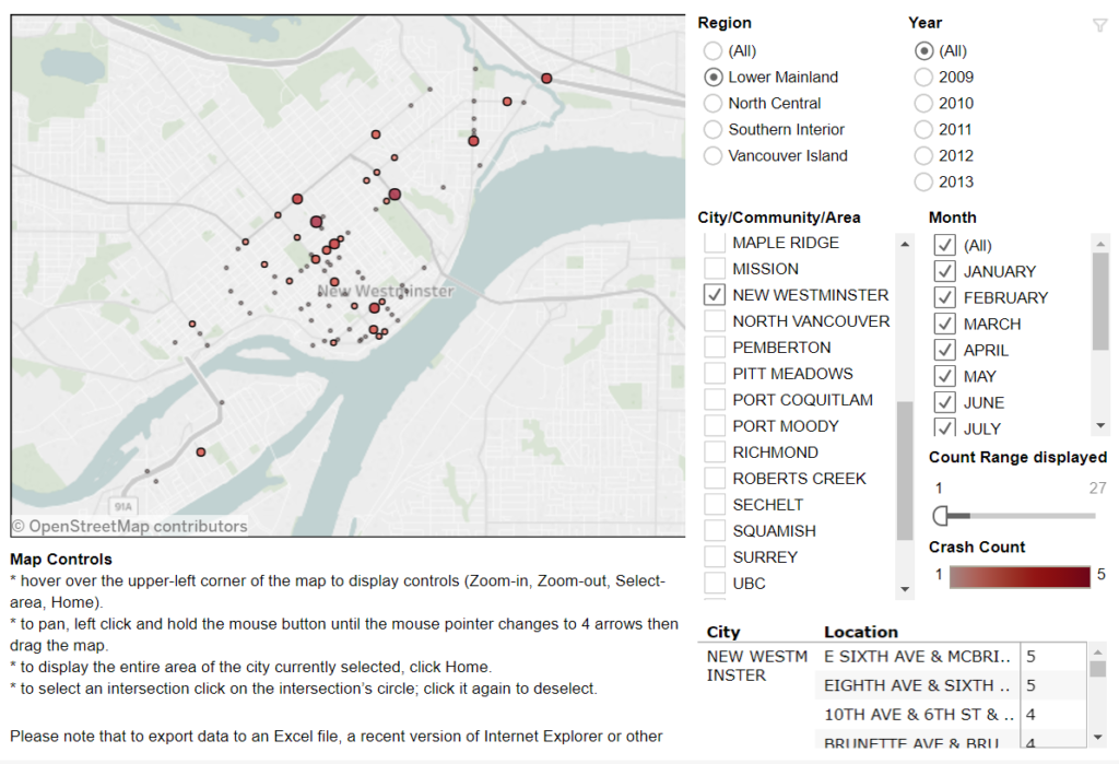
Anecdotally (and off the top of my head) I can think of two cyclist and three pedestrian deaths in New Westminster in the last few years (there have surely been more). One of them I am comfortable in calling an “accident”, a second was clearly an act of negligence on the part of a pedestrian. The rest were just as clearly acts of negligence on the part of the drivers of a vehicles, resulting in the death of 3 innocent road users. I have also spent the last year watching a good friend struggle through recovery from a near-fatal cycling crash where he was clearly a victim of a negligent driver. New West is not unique here, as across the region, there is news every day of cyclist endangered by the negligence of drivers.
Of course, I acknowledge the obvious point that cyclists and pedestrians also sometimes act negligently, and cause accidents. However studies have shown that accidents causing injury or death of pedestrians and cyclist are in the vast majority, caused by the actions of drivers, most notably not yielding right-of way while making turns.
That said, we are talking about infrastructure, and part of designing and investing in transportation infrastructure is in making it harder for people (drivers or vulnerable users) to be negligent, and to reduce the potential impacts of any negligence on vulnerable road users. We can do this through design that reduces conflict points, improves visibility, slows cars, or puts barriers between vulnerable users and the vehicles that endanger them. At some level, this should be the primary goal of all transportation engineering. But perhaps I am already digressing too far from the point, so let me answer more succinctly:
We don’t measure the need for a bridge by counting the number of people drowning in a river.
The second question seems to be more relevant to how governance works: What kind of data do we use to make transportation investment decisions?
The City passed a Master Transportation Plan back in early 2014, and it sets out priorities for the City’s transportation investments. It was developed in context of a bunch of other planning documents, including larger regional plans like the Metro Vancouver Regional Growth Strategy and the TransLink Transport 2040 regional transportation plan, both of which the City participated in. Internally, we have our own Official Community Plan (currently being updated), a relatively recent Sustainability Plan, and a variety of other strategies to make the City more equitable, safer, livable, and sustainable.
These plans all point to making active transportation modes (pedestrians, cycling, and transit) easier to access, safer, and more comfortable, as an important strategy towards the larger regional and local community development goals. This was reflected in our Master Transportation Plan with an established hierarchy for our transportation system: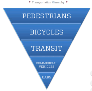
In an ideal world, our transportation spending would reflect that hierarchy, but we are not there yet. This year, we will spend something like $4 Million* on asphalt, mostly to make roads smoother for drivers. At the same time, we will spend about $500,000* on sidewalk improvements and maintenance (which represents a pretty significant proportional increase over previous years), and the Crosstown Greenway improvements that started this entire conversation will cost us less than $125,000*. By any measure, the hierarchy in the MTP is aspirational, as travelling by car is still the preferred mode for a little more than 60% of residents.
(* all budget estimates, very close to reality, but not exact numbers)
So the City has a well established and regionally-supported goal to encourage active modes, mostly by making them safer and more comfortable for all users. The only question left is what evidence do we have to suggest making active modes safer and more comfortable encourages their use, or provides the livability, sustainability, and inclusion goals the City is after?
I could start with Montreal, or Copenhagen, or Medellin, or even Vancouver. I can refer you to books by Jeanette Sadik-Khan or Charles Montgomery. We are not inventing a new wheel here (we are too small and too fiscally conservative a City to do that), but we are taking the best of what other jurisdictions have already demonstrated to work, and are warned by failures in other jurisdictions.
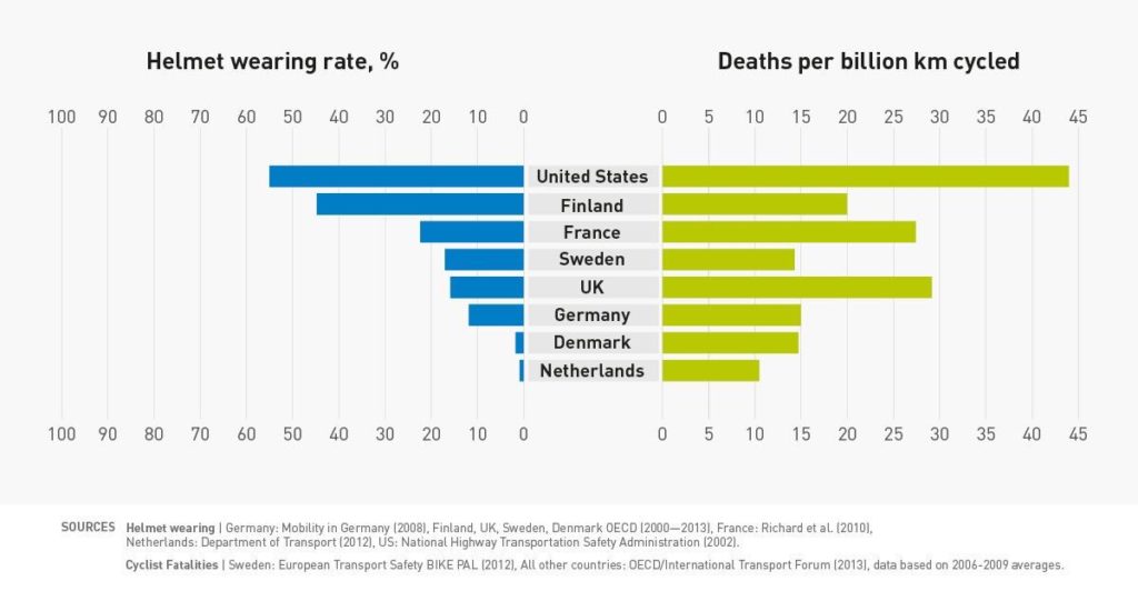
If you want to dig in to the academic underpinnings here, I can link you to resources about how protected bike lanes save lives and reduce injuries, and studies showing that communities where people are encouraged and supported in choosing active modes are happier, healthier, and more inclusive ones. Perhaps most importantly, I can show you the data that building proper infrastructure increases the number of cyclists, which actually correlates with cyclist safety much more than does helmet use (for example):
 The Crosstown Greenway improvements are very small part of our transportation budget (less than 3% of this year’s budget for road improvements), and has numerous potential benefits to the community at large. As the City’s first foray into modern separated bikeway design, it may have a few kinks to work out, and it may take a bit of time for drivers to get their head around the new layout, but it is based on well-established design principles, and is a big step towards creating a safe, effective, and all-ages cycling network in the City.
That said, they were done as a bit of a trial, and I encourage everyone to let the City know what you like and don’t about the design – and provide suggestions about how the City could improve upon the design.
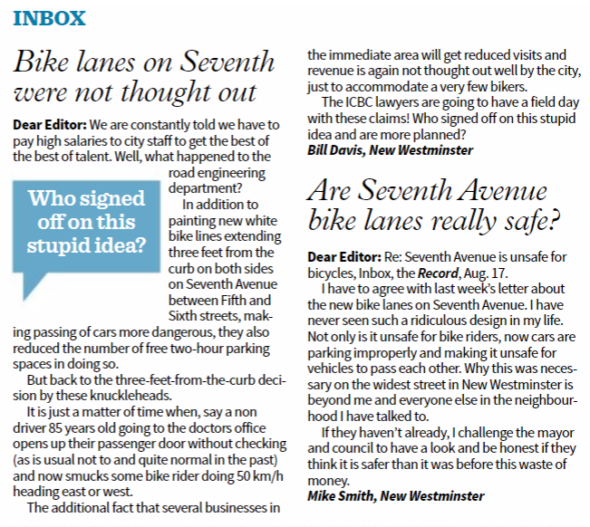
POST SCRIPT: I swear I did not read the New West Record that came out today before writing this post…
> and cannot be filtered by injury/death/property damage
Of the two ICBC crash maps, the pedestrian map is not filterable but the general “crashes” map is. The “Crash Type” dropdown allows you to filter by “casualty” or “property damage only”
Hi Patrick:
Good ;article! Keep up the good work!
Arno
I’ve ridden the crosstown a few times now (it’s occasionally on my commute) and have come to a mixed opinion on the changes. First, kudos on the city for trying! Keep trying new things to improve cycling infrastructure!
I see the changes are suitable for some groups, but not others. I think it’s a vast improvement for family type riding. You’re lower speed and more protected if you’re out with children.
If however you’re commuting at speed, I’ve found it to be a mildly uncomfortable route. I find myself feeling (note, only a feeling, no evidence that I’m correct) pinned and possibly unable to maneuver due to a lack of space if something unexpected happens. I also feel invisible to the traffic on the road and I’m not sure the buffers for the driveways are sufficient space if you’re at commuting speed. Lastly, and easily corrected, the surface on the sides is terrible. It makes for a very unpleasant ride at speed.
I have a simple solution though. When I ride with my kid, we ride in the new bike lanes and I feel she’s safer. When I’m commuting, I ride on the roadway and hit it as hard as I can so I minimize slowing down cars since there’s less space for them to get around me (but really, it’s a residential stretch, they shouldn’t be going that fast anyhow).
Good on the city for making a proactive investment and I hope they continue and get better.
One thing I’d like to see all planners doing is making it clear who the target audience are for the improvements. Unless you have ample space to play with, it’s hard to make one size fit all. But really, encouraging family rides is probably more important than encourage my rides. It’s probably better for the commuting.