Ask Pat: Q2Q Ferry

I am a little behind on my Ask Pats, I apologize. there are a few in the queue, but work, life, and an amazing array of community events have kept me away from the computer keyboard. I’ll try to catch up.

BoatRidesAreFun asks—

Hi Pat,

Any updates on the Q2Q ferry that was supposed to open July 1? I haven’t seen anything happening at either of the docks.

The ferry has been a challenge. This is one of those times I am glad I am an Elected Type setting unreasonable expectations for staff, and not City Staff trying to meet the unreasonable expectations of the elected types!

The good news is the the trial is ready to go, and will be starting this weekend. The Ferry will run on weekends and holiday Mondays in August and September from 9:00am to 7:00pm, and from 5:00pm to 9:00pm every Friday in August. It will run every 20 minutes, and will cost a Loonie or a Twoonie. The route will be from the Quay (near the Inn) to the public dock on the south side of Port Royal. The bad news is that the limitations of the project as a “pilot” will mean it falls short of some expectations, and that could benefit from some background explanation, so I am glad you asked.

Running a passenger ferry turns out to be a much more complicated process than you may think. You need a boat and operator, you need (at least) two places for it to dock, and you need permission from several different agencies responsible for keeping people from drowning as a result of poor planning.

The first issue was surprisingly hard to solve. The Fraser River is a dynamic, working waterway. There are tides reaching 9 feet in range, and tidal and river currents that flow in different directions up to 10 knots. These currents shift lots of hazardous debris like large logs. There are also tugs, barges, and large ships moving around the river. The little tubs used to shuffle tourists around the relatively safe tidewater of False Creek were not going to work on the Fraser. Something more skookum (to use the nautical term) was required. The more requirements the City put on a boat (number of passengers, weather protection, accessibility, room for bicycles, operating cost), the more limited the number of available boats just sitting round BC waiting for hire.

Then we need two places to dock the boat. Installing a new dock facility in tidewater in Canada is not a simple process, as it activates everyone from the local Port Authority to the Marine Carriers and environmental agencies including the Department of Fisheries and Oceans. For a short-term trial, the City really needed to find already-existing docks.

Ferry_Map(1)

The public dock at Port Royal was there and available, but designed for small pleasure craft, not to accommodate a passenger ferry. Significant changes would intrude into water lots owned by Port Metro Vancouver, who were helpful and accommodating, but had their own safety and operational concerns that had to be addressed. On the Quay side, the only functional docks are operated by the Inn at the Quay (where the paddlewheeler tours launch from) and the industrial dock operated my Smit. Again, both had challenges with accommodating their established operations with a new every-20-minutes group of passengers, many of whom are not that accustomed to walking around industrial marine operations, and who will create no end of hassles if they fall into the drink and get dragged downstream. Again, a deal was worked out and operational concerns managed.

At this point, City Staff need to be acknowledged for managing a significant number of potential game-stoppers here, but in the compromises required to make this work are the inherent flaws in the final plan. During this summer, we are going to have the trial ferry service that was possible, not necessarily the one we want.

When I think about connecting the Quay to Queensborough, I am not thinking of it as a tourist draw or a piece of recreation programming, I am thinking of it as a vital transportation link. To be such a link, it need to be reliable, available for daily users, and fully accessible. The trial ferry is going to fall short of this. The high tide range and reliance on existing dock infrastructure means it will not be fully accessible to those with some mobility challenges at all tide stages. Running the ferry only on weekends with limited hours means it will not be useful for work commuters wanting to get from Port Royal to Downtown or Skytrain. The limited hours will further cause people crossing the river for diner and a drink to look closely at their watches while waiting for the bill to arrive. The City recognizes these limitations, but also recognizes the value of getting this project running to see how the public reacts.

In the end, I hope people will appreciate this is a test-of-concept trial, and not the ultimate solution to connecting Queensborough to the Quay. Its successes may be limited, but there has already been a lot learned by the City just in setting up the service, and there will be much learned during its limited run, both in it’s success and where it falls short of expectations. I hope that people on both sides of the North Arm will come out to support this pilot, and provide your constructive feedback to the City, so that we have useful info to inform planning for a more permanent solution.

…on the Stairway

“A Stairway to Nowhere”. Literally the second paragraph of the story undermines the headline, but Global never lets a good lede go to waste, reality be damned.

The alleged “Stairway to Nowhere” is a fire exit, required by the building code because the ~100-year-old heritage buildings adjacent do not have internal staircases to facilitate fire egress in the event a fire or other emergency blocks the front entrance. The connections between the staircase and the building have not been completed yet, because the ~100-year-old heritage electrical connections to the ~100-year-old heritage buildings are going to be moved to make the Front Street Mews look and work better, and life will be better for everyone if the lines are moved before the fire escape connections are made.

The fire escape needed to be built because the Parkade was removed. The ~100-year-old heritage building used to have gangways that connected to the Parkade to facilitate fire egress. Those were part of the “railings, lights, stairs, wheelguards, and other ‘jewellery’ [that were] past their service life and [fell] far short of modern safety codes” that I talk about in that blog post from 2015. Until the new connections are made, there is a lighter-duty and even more temporary fire escape on Columbia Street which is (arguably) as intrusive as this one. The owner of the ~100-year-old heritage building, naturally, has some say in how these connections are made, and is apparently quite satisfied with the stairway on Front Street.

20170725_120448

The cost of installing this stairway or otherwise providing alternate egress for the ~100-year-old heritage building is not an unexpected expense, but part of the (budgeted) $11 Million cost of the Parkade half-repair, Parkade half-removal, Front Street re-engineering and general gussying-up project that was approved by Council a couple of years ago. At last report, this project is still on budget, although its finish was delayed for a bunch of reasons that were reasonably unanticipated. There were some changes to the design over the couple of years since first proposed, not the least being that all of the electrical services were undergrounded, which is a significant improvement to the aesthetic of the Mews, and will make the pedestrian realm more friendly.

All of this doesn’t mean I am happy with the staircase (**insert part where I say this is my opinion, not official position of the City, Council, or anyone else**). I was actually pretty (excuse me, Mom) pissed off when I first looked at this temporary solution for the fire escape and it was explained to me that “temporary” meant “for the foreseeable future”. Looking back at the many renderings for the Front Street Mews used for public consultation over the years, the stairs were never depicted, and to me the structure is oversized, obtrusive, and at odds with what vision we are trying to create on the Mews. With our Open Space planning staff doing so much good work to make Front Street a comfortable, human-scaled, and functional space, this looks like something designed by (I’m sorry) an engineer.

vision-2
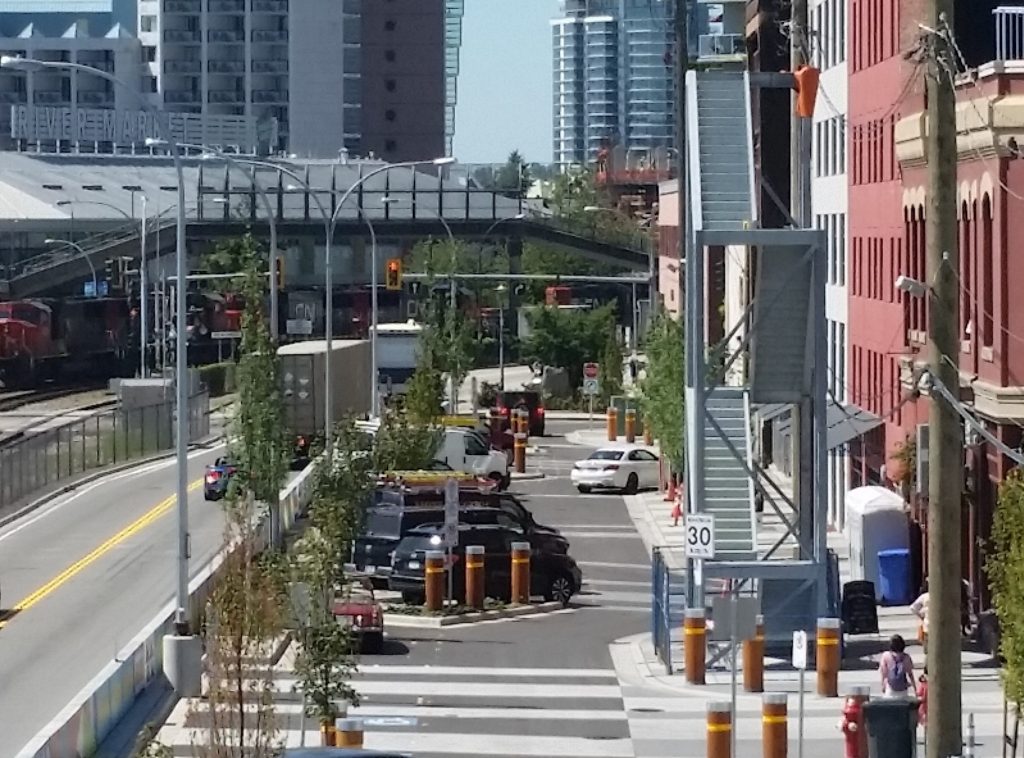
My first reaction was to think that a fire escape, by its very nature, would be used by a half-dozen people only once, if at all. This structure looks like it was engineered to facilitate the boarding of troops onto naval vessels. However, I am told that modern fire access standards for commercial buildings expect that well-equipped firefighters will use the stairs, and carry large things up and down them with some significant urgency. The stairs are also expected to remain standing after a seismic event that no ~100-year-old heritage building was built to sustain. So it is bigger, stronger, and with a much more substantial foundation than the stairs going (for example) up to the back deck in my house. It is also a modular design that can be picked up and moved, as it was recognized at the time as a “temporary” structure, which can be utilized elsewhere if ever major renovations to the ~100-year-old heritage building make the stairway’s presence on Front Street no longer necessary. Put these factors together, and the design, fabrication and installation costs are more than my aforementioned deck stairs.

Other options were explored by staff and the owner of the building. Maintaining access above Columbia Street was suboptimal, building an access on the McKenzie Street side simply didn’t work with the internal layout of the ~100-year-old heritage building. No-one was excited about the potential engineering challenges of hanging something that met modern standards off the side of a ~100-year-old heritage building. So in the end, they are ugly and look overbuilt, but represent the best of several bad options given the circumstances. I don’t like the way the stairway looks, but have no viable alternatives to offer.

Nor, I note, do the armchair engineers or outrage-mongers at Global.

Ottawa as a City

As I previously wrote, I attended FCM this year, which was held in Ottawa. I had not been to the Nation’s Capital for something like 25 years, so after the meeting, I stayed a few extra days to visit some family and look around the City, concentrating on the holy trinity of nouveau city-making: public spaces, transit, and cycling infrastructure.

Ottawa has numerous amazing public spaces. Everywhere we went, there were public parks, squares, and market areas. At first blush, it appears to be a model for use of public space. Problem is, it seemed these were mostly serving tourists. Perhaps it is a result of me being a tourist (and my resultant gravitating towards “tourist areas”) I found a general lack of outdoor activity and “street life” compared to Vancouver or other large cities in Canada. Ottawa seems to be City where folks pack up after work and go home, leaving some surprisingly empty public spaces on a warm summerish evening.

The most active street in downtown Ottawa at 10:00 on a Thursday  night.
The most active street in downtown Ottawa at 10:00 on a Thursday night.
The Market area has some nice Public Spaces,, though mostly for tourists, not denizens.
A cool use of public space in the Market area on a Friday night- Movies on the Street!

Of course, Ottawa is a lot of things: a political town where many of the workers get out of town on the weekends, a tourist town full of museums and important institutions, and a town where business gets done on a government schedule. Comparatively, the high-tech worker town is a new phenomena, so it still relies on expanding suburbs and exburbs, and shares a workforce with Hull / Gatenau (but has virtually no transit service across the river). When I arrived it was midnight, and I hopped on the bus to the hotel and arrived late in the evening to find downtown not just empty, but Zombie Apocalypse abandonment empty. It was eerie. There is virtually no mixed-use development downtown, but not too far away are leafy neighbourhoods of real mixed density, from single family homes to quadraplexes and townhomes. There were some interesting developments happening, and Sparks Street was trying really hard to be somewhere, but no matter where we went, it never felt like a vibrant City.

Much of downtown was being dug up to install new subway lines.

That said, much of downtown Ottawa is under construction, as a light rail system is being constructed to replace some of the dedicated “Transitway” routes, the “Bus Rapid Transit” system that has connected Ottawa to the burbs since the 80’s. This system is a model for what some other metro regions have considered as a “stopgap” between buses and light rail systems. It is fundamental to the transit in Mexico City, Bogota, and other cities, and some have even suggested this as the best way to get transit up the Fraser Valley along the Highway 1 route. As a people-mover, it worked great. However, it was notable that the limited stations didn’t appear to spawn development booms like we would expect to grow at a “real” rapid transit station that connects to downtown of a major City. Still, for $3.50 from the airport, dedicated road to avoid traffic congestion and super frequent service, the Transitway couldn’t be beat – maybe 75% of the service of SkyTrain at probably 25% of the cost.

Airport to downtown in less than 30 minutes for $3.50. and little traffic delay. Nice.

We also discovered that Ottawa (at least in the summer) is definitely a cycling city. There are bike racks throughout downtown, and they were full of bikes on business days. There is a comprehensive bike route network along the numerous waterways and canals that run through the City, and decent bike infrastructure in the more trafficked areas, though the map is not completely without gaps or terrible design choices.

Downtown had lots of bike racks, and they were all bulging with bikes.
Away from downtown, not as many bike racks, but bikes were still parked everywhere.
Although the bike routes along the Canal s were great, and a few separated routes existed in downtown, there were still some notable infrastructure gaps...
Although the bike routes along the Canal s were great, and a few separated routes existed in downtown, there were still some notable infrastructure gaps.

I took a couple of opportunities to use Ottawa’s bikeshare program, VeloGo. The system is very similar to Portland’s, in that the network and booking electronics are installed in the bike, and the bike’s location is tracked using GPS, allowing you to drop bikes everywhere, not just at the “stations”, although it is less expensive to drop them at the station, and it is generally hard to find one to pick up anywhere but at a station. The system is easy to use, and the durable, shaft-drive upright bikes worked great.

A quick spin between conference/lunch venues is where bike share shines.
The bike share bikes were typically Euro (upright and durable), but not sure I've ever seen a shaft-drive bike used this way before!
The bike share bikes were typically Euro (upright and durable), but not sure I’ve ever seen a shaft-drive bike used this way before!

Unfortunately, the station network and number of bikes is pretty limited, and concentrated along the aforementioned canal routes with no stations in the downtown, so the system was (are we sensing a theme here?) more useful for tourists than for the residents of the City. It was simply not a viable alternative for short cross-town trips, like my daily 15-minute walk to the conference centre, or for the 20-minute walk to the Museum of Canadian History where a reception was held. This was disappointing, because it was trip like that that are perfect for bike share, and will make the system a sustainable part of the transportation network instead of just a tourist curiosity. Compared to New York or Montreal, the system seems like a half-assed effort.

In short, Ottawa was a great City to visit, for the obvious reason: there is so much to see and so much history. Riding a bike along the Canal and through the ample green spaces was pleasant, but it curiously lacked the feeling of a vibrant City where residents enjoyed public space. It felt like too many US cities where the downtown is for business, and the burbs are where people live their lives. Which was in contrast with out next destination: Montreal.

Pattullo EA

With all of the excitement around elections, renewed commitments to transit funding somewhat confounded by unclear priorities around the application of road tolling, it is easy to forget the Pattullo Bridge is falling down and scheduled to be replaced very soon. At this point, it is unclear how the replacement will be funded, but it is clear right now that the existing structure is unlikely to be carrying traffic in 2023, so unless they get busy planning the replacement, we will be entering uncharted territory.

Translink is continuing to get busy with that planning, and is currently involved in the Environmental Assessment (“EA”) process. I write about this now, because you have until the middle of next week to provide your first round of input to that process.

The need for an EA is mandated by the province, and the EA itself is run by the Environmental Assessment Office, not by Translink. It is a fairly tightly regulated process, with a structure and firm timelines, so if you at all care about the Pattullo (and I think most people in New West fall under this category), you might want to take your chance to comment while they are open. I thought I might outline the process a bit here, not to tell you what to comment on, but to help you understand the process so your comments have the best chance of being heard.

The first stage of any EA is the pre-application stage when the terms of the EA are determined. The primary purpose of this stage is to evaluate what impacts (positive or negative) will be created by the project, and what are the potential targets of these impacts – so “sediment in the river” is a potential impact of construction work, and “fisheries habitat” is a potential recipient of that impact. The second stage is the actual “Assessment”, where these potential impacts are assessed to determine if they are real, and then to make adequate mitigation of these impacts a condition on moving forward with the project. To have a project (any project, be it a bridge, a mine, or a pipeline) refused an EA certificate would be very unusual. The more likely process for an EA to kill a project would be to create conditions that make the cost or hassle of mitigating an impact so high that the proponent will decide not to proceed. I don’t think that will be the case here.

By necessity, an EA has to have a project to review. So the proponent has to provide a project description to hang the assessment on. It appears, from the preliminary documentation provided by TransLink to the EAO, that project is “a new four-lane bridge funded primarily by user pricing” and “located north and upstream of the existing bridge, its approaches will connect to McBride Boulevard in New Westminster and the King George Boulevard in Surrey” , which is consistent with the public consultation work TransLink has done to date and with the MOU between TransLink, Surrey, and New Westminster. This is important to recognize, because comments like “they need to build 8 lanes for future capacity” or “they should build the bridge in a different location” are not relevant to the EA. Those arguments were made, and discussions had, over the last 5 years while the project was being developed, they are not the current plan, and the EA is not the process through which a radical change of plan will come about. In essence, the question in the EA is not “how best to connect Surrey to New West by roads”, it is “what impact will this 4-lane bridge proximal to the existing one have”. Comments addressing the first question are interesting, but not relevant to this process.

So the comments the EA needs right now are pretty limited, but foundational to the EA to come. Have TransLink and the EAO appropriately identified potential impacts? How do you think the proposed project will impact your life, the livability of your neighbourhood? What concerns you about the project as proposed? If you want TransLink (or other parties, such as the Ministry of Environment) to address something as part of this project, now is the time to ask, so it can get into the EA early, and the proponent has an opportunity to properly address it.

Picking a random example, I have talked in the past about how the Pattullo is an iconic structure. It has significant heritage value for the City of New Westminster. It is hard to finds a picture or photo of the City over the last 75 years that doesn’t feature the large orange arch defining the skyline. There is a value to that for our community. I don’t know how the EAO or TransLink can address that value, or what kind of mitigation can happen, but if we don’t raise that as an issue important to our community now, it will not get into the EA review, and an opportunity to discuss that aspect of the design of the bridge will be lost.

There is another issue that I hope will become clearer as the project EA proceeds, and this might be a bit wonkish. How valid are the traffic modelling assumptions baked into the assessment?

Transportation Planners and City Planners understand that traffic is impacted by induced demand. If we build a 4-lane bridge to replace an existing 4-lane bridge, there will be no more than a marginal increase in traffic counts (perhaps induced by a wider, safer, bridge configuration). That small increase in traffic is fundamental to a bunch of other impacts that will be measured – air quality impacts, noise and vibration, economic impacts, etc. However, if the traffic numbers coming out of this model are based on false assumptions about traffic, then all of the resultant data will be similarly flawed, and mitigation will not be appropriate. With all due respect to our regional transportation planners, the last two major bridges built in this region have completely failed to reach modelled traffic volumes – let’s not three-peat that mistake here.

So if this bridge is being built to accommodate future expansion to 6 lanes, how does that increase in traffic capacity (and concomitant induced demand) change those impacts, and (more importantly at this stage) is that being assessed as part of this project?

Then we have to raise the uncomfortable subject of tolls. The MOU and Project Definition both call for a tolled bridge, and the recent election seemed to indicate the province is now cold on the idea of bridge tolls. There is some time (this bridge will not be built until 2022 at the most ambitious rate) for the region’s Mayors to work up a regional road pricing scheme as envisioned in the 10-year plan, but that is something different than specific tolls on this bridge. As we have learned from recent experience, tolls significantly decrease demand for bridge infrastructure, so if this EA is based on traffic models based on toll aversion behavior of drivers, is that base assumption still valid? This is the type of thing we need clarity on right now.

Finally, there is an area of the EA where the cumulative impacts of multiple concurrent projects can enter into the assessment. The idea here is that one project may have a small, but acceptable impact on a valued part of the environment, but 10 similar projects on the same river will have a bigger impact. However, this is a transportation project, so cumulative impacts may be thought of in a different light. What impact will the (potential) cancelling of the Massey Bridge have on regional transportation (and the resultant traffic modelling?). Perhaps more important, what impact will SkyTrain/Light Rail in Surrey have on regional transportation patterns, and the assumptions feeding the transportation plan?

So that is long way of saying, if you care about the Pattullo Bridge and the impact its replacement will have on New Westminster, do a bit of reading here, and take the time to provide some comments to the EAO before the end of business on July 26. Then hold tight and wait until early 2018 when the full EA process starts.

paint

The Grand Prix

The New West Grand Prix happened last week. Our City joined Vancouver, White Rock, Delta, Port Coquitlam, and Burnaby in hosting a BC Superweek professional bike race. And what a show it was. You can read the good news stories here, here, and (especially) here. But this is my Blog, so I’m going to take my time to (space?) to thank the many people who need to be thanked for making this project work. At least, I will try to thank as many of them as I can think of. An event like this is a partnership between many groups, and I’m going to risk missing a few important people here…

1

First and foremost, we had an army of volunteers making this happen, some who gave a few hours on the day, some who spent month ahead of time putting vital pieces in place. Community member Ron Cann provided great leadership and savvy guidance as the Chair of our organizing committee, Diane Perry organized the kids’ races and events, Bill DeGroot shook the bushes of the community for volunteers, and he and Jennifer Wolowic made sure the volunteer efforts were as organized as could be. Jennifer was also a star on Race Day, bringing her knowledge of high-level cycle racing to do any of a thousand small tasks that needed to be done. Mario Bartel helped put the Grand Prix on the social- and traditional-media map, and did what he does best by capturing stories through his camera lens. Ross “Mr. Jen” Arbo helped find a bunch of places for visiting racers to billet here in New West. This was the command structure of a volunteer army.

Add to this core group more than 100 volunteers who did everything from set up and tear down fences to standing at crosswalks for hours keeping people safe and many other tasks you didn’t even see being done. Here is where the greater New West community stepped up. We had teams from the local HUB Cycling chapter, The Queens Park Running Club, and from the Fraser River Fuggitivi road riding group. We had corporate teams, Youth Ambassadors, and a team from Last Door who were particularly adept at large-fence-panel moving, and scores f individuals who just wanted to help out. I don’t know where Bill found all of these people, but the first time I felt confident about this event working was the day of the Volunteer Dinner, a week before the event, when more than 100 people showed up eager to help make race day work. Thank you to everyone!

I want to thank some City staff who really stood up, but I don’t want to name them (I am, in some weird sense, their employer, and privacy rights and all…) I think they know who they are, and I’ve tried to thank them personally. An event like this pushes them past what is normally “just their job” and takes a passion and effort that is out of scale with their everyday, and so much of this work occurs of the side of the desk along with their everyday busy schedules. Council put a little extra stress on our staff because we (frankly) started a little late on this project. This meant we had to rush some parts of the program, it also meant we weren’t able to do a few of the things that would have made the program bigger or more exciting (many learnings in the can for next year!). However, staff coordinated with the volunteers and those running the bigger BC Superweek program and answered a thousand phone calls and e-mails about every aspect of the event, then showed up on event day to do a thousand tasks, big and small. Kudos all around.

This event relies on sponsors to pay a huge portion of the bills. Again, we were a little late to get started in 2017, but it is incredible how many sponsors stepped up to contribute. Bosa Developments, Domus Homes, I4 Property Group, and Skyllen Pacific were all major partners with the City on this community-building adventure. Strongside Conditioning and Billard Architecture were two local businesses that had their front door access impacted by the event, but turned that into a reason to get involved as major sponsors.

Of course Gordon from Cap’s Original Bike Shop got involved, providing prizes for the kids race, a great draw prize for the volunteers, and the professional “pit services” for the race. Boston Pizza made sure VIPs and volunteers got fed, S&O partnered to keep folks otherwise refreshed, and the Record and Global BC helped get the word out. Champion Systems, Gateway Casinos and Alpine Credits also pitched in, and Old Crow Coffee hosted our volunteer corral. Next time you visit one of these sponsors, thank them for taking part and helping to bring this event to New West. We really couldn’t do it without them, and they are making your City more fun to live in.

Similarly, we got a lot of support from downtown New Westminster. Both the Downtown BIA and Tourism New West came on board with support, but the merchants and residents of downtown also made adjustments to their day to allow us to have one of the large road closures in recent New West history. Can’t have a road bike race without a road.

Finally*, the fans and racers. The show was great, a kicking of butt by the Woman’s winner, and a late break almost caught by the sprint in the Men’s race… there were no spills but many thrills, and a marriage proposal to cap it off. The crowd was above expectations for our first year, and seemed really enthused by the event. It was a good evening. So whether you volunteered, sponsored, raced, spectated, were inconvenienced by the traffic, or just wandered by and asked “What tha heck?”, then decided to watch for a bit – thanks! I love when this town shows up!

*postscript: Thanks to Councillor Trentadue for invoking Rule #5 at the best possible time. You were right.

Council – July 10, 2017

The final Council meeting before the summer break occurred on July 10. We don’t meet again until the end of August, which is a bit of a relief as there is so much going on in New West this summer, it will be nice to be able to enjoy my annual summer stay-cation. But first, the work. Our Agenda started with a presentation on progress on a big development project:

Sapperton Green (97 Braid Street): Master Plan Update
Sapperton Green is a big project. A 38-acre site sitting right on a Skytrain Station adjacent to Highway 1. The Official Community Plan for the property includes 3,700 homes for something like 7,500 residents, 150,000sq.ft. of retail commercial space, and up to 1,500,000sq.ft. of office commercial space. There will be a mix of building types, including about a dozen towers up to 35 stories.

A project this size (the first of this scale since Victoria Hill) takes a lot of planning and development work. The Official Community Plan Amendment, adopted in 2015, was the first high-level step, where the numbers above around square feet and land use types were determined. The next step is to perform a Master Planning process, which is where the project is now. This is the step where big decisions are made about the layout of the site, where buildings will be and where greenspace will be, what type of community amenity will be provided, and where those amenities will be located. This is also the stage where high-level details about how the ground level of the development will work, with transportation connections and parks.

There is a lot of work to do yet before we start seeing shovels in the ground here ,and there will be more public consultation, however today’s report was mostly for staff to get endorsement from Council on some of the “big principles” defining the shape and form of the development (listed in part 6 of the report).

This project differs from Victoria Hill in two ways: it is a mixed use community instead of a predominantly residential neighbourhood, and it needs to be a permeable site for pedestrians especially, because it will be located between Sapperton and a SkyTrain station, and will become a commercial centre and will have amenities servicing Sapperton as much as its own residents. In that sense, we need to think of how its connections integrate with the surrounding community in a different way than Victoria Hill.

There are some concerns about what this project means to the district’s school capital development plans, especially at the Elementary and Middle School stages, but there is some time for the School District and the Province to manage those long-term plans. The population growth anticipated here is completely consistent with the Official Community Plans back to the late 1990s, and with the Regional Growth Strategy, so it should be no surprise to anyone involved in long-term regional planning. The population is coming, what we need to provide now is some more certainty about timing and distribution of new residential development.


The following items were Moved on Consent:

Proposed Derwent Way Soil Transfer Facility
This project on Port Metro Vancouver land in Queensborough is going through a similar type of Port-driven environmental review as the Fraser Surrey Docks coal terminal project. As such, the City being asked to opine on the project as it will have impacts on City roads, drainage, and land use.

The basics of the project is that a company wants to use a piece of Port land adjacent to the Derwent bridge to transfer soils from trucks to barges so it can be shipped upriver to a storage/processing facility. These soils will include contaminated soils from development, but not soils deemed as “hazardous waste”. This is a bit technical (and within my area of professional practice) so maybe I will explore it a bit more in a future blog post.

The neighbourhood is going to have a reaction to contaminated soils being stored next door, but our staff have appropriately identified impacts we should be concerned about – how the increase in trucks impacts neighbourhood livability, how dust and vapours will be managed on site, and how site drainage will be managed. If you are a concerned citizen with opinions, you can take part in the review by following this link.

914 Thirteenth Street: Heritage Alteration Permit No. 106 for Work on Designated Heritage Property – Request for Issuance
This heritage house in the West End is Designated, meaning it is a protected heritage asset. The owners wish to make some changes to the house to improve livability, and because it is Designated, require a Heritage Alteration Permit to assure the heritage values of the house are protected. Council moved to approve this permit.

Walk New West Initiative – Update
This was an information report, following up on this spring’s walking advocacy initiative. It was a good program, and relied heavily on the support of a burgeoning Pedestrian Advocacy group that had formed in the City (The Walkers Caucus). The “challenge” part of the program was perhaps a little long and a little complicated, but most participants enjoyed it, and for a first year, it was a great launch. I look forward to 2018, and to more activity by the Walkers Caucus speaking up for the needs of pedestrians in our City and the region.

Latecomer Agreement for Extended Servicing Costs Related to the Subdivision of 1004 Salter Street
This may be a little too “inside baseball” for some, but let me try to summarize, because understanding this is a pathway to understanding how growing cities get developers to pay for utilities.

When a developer wants to build a neighbourhood that significantly increases density, it means the City’s utilities need to increase capacity by building new or larger water and sewer lines. The City gets the Developer (and, ultimately, the purchaser and user of the utilities) to pay for these, either by the developer building them, or by collecting Development Cost Charges which hare set aside by the City and are specifically and legally earmarked to pay for the cost of those capital works.

However, sometimes these density increases occur adjacent to other areas where future growth is planned, and the City wants the utilities to be upsized now not just for the current development, but for future development. Why build twice when you can build once? One way to make this happen is to get the developer to build bigger than they currently need, and then recover those extra costs from the next developer who comes along to develop that next adjacent property. To do this, the City sets up a “latecomer” agreement, allowing the City to collect money form that latter developer (when it happens) and give it to the current developer who is paying for the increased utility works installed now.

This report outlines the principles of a proposed Latecomer agreement for a development in Queensborough.

Street Closure Bylaw No. 7935, 2017 – Wood/Boyne Street Animal Services Facility
The City is building a new Animal Services Facility in Queensborough on land we already own, however part of that land is currently designated as a road (although it is forested, and the road doesn’t connect to anything). So by law, we need to officially close the road so it can be repurposed.

Temporary Relocation of Queen’s Park Arenex Gymnastics and Trampoline Programs Update
Our Parks and Recreation staff have been working hard to manage the various aspects of the post-Arenex-collapse plan. We are finalizing work on a short-term replacement structure and integration of some programming with the proposed Canada Games Pool replacement, but there has also been a lot of work finding solutions to the programs that have been displaced by the Arenex collapse so they can maintain continuity. This information report provides a bit of detail about the hardest-to-house programs, as the trampoline programs especially require pretty specific spaces. This is an ongoing work in progress, and will be until the temporary replacement is brought on line. Hopefully, there will be more news on that shortly.

800 Columbia Street (CPR Station Site): Rezoning to Allow Liquor Primary Licensed Premise – Preliminary Report
The cat is out of the bag about the restaurant operators who plan to open up this Fall in the old CP Station / Keg Building at the foot of Eighth Street. This rezoning application will allow the proponents to operate both a “food primary” restaurant and a “liquor Primary” pub in the same building. As this is a rezoning, it will go to public consultation, including a Public Hearing, so I’ll hold off my comments until then.


The following items were Removed form Consent for discussion:

232 Lawrence Street (Child Care Facility): Official Community Plan Amendment Section 475 and 476 – Consultation Report
232 Lawrence Street (Child Care Facility): Grant Funding Update
There are two things going on here, both related to the re-purposing a piece of City land in Queensborough to host a critically needed child care facility in that community. The first is a report on consultation for the required OCP amendment and zoning changes (local government sausage-making), and the second is about the City’s budget for this project.

There was quite a bit of discussion about the second point. The City is planning to tap into some Provincial Grants available to fund the capital investment required to build the space, and will use a not-for-profit to operate the facility. However, we need ot dedicate some capital budget to make both of these things happen. The extra money the City is putting up comes from the General Amenity Reserve – money collected from developers to increase density in order to provide exactly these kinds of amenities, and I am satisfied that this is an appropriate use of those finds, especially in light of the opportunity to leverage 4x the amount we invest from senior governments, and that child care is the #1 amenity priority for the Queensborough neighbourhood.

701 Sixth Street (Glenbrooke Daycare Society): Request for Financial Assistance
This is the other side of the coin. There are several child care facilities in the City struggling to pay the bills and keep services affordable, and capital costs for expansion are a challenge for them all. The City has a reserve fund for childcare, and a staff committee who determines the best use of these funds. It hurts to not be able to say Yes to every request, but I respect staff’s recommendation about how to best use limited funds to have the bidggest impact, and this application doesn’t seem to meet that test.

Construction Noise Bylaw: Proposed Changes to Permitted Hours and Pile Driving Technologies – For Consideration
This update to our construction Noise Bylaw will reducing pile driving hours on Saturdays, and look towards methods to encourage quieter and less disruptive pile technology. The first is something some other Lower Mainland communities do, and this brings us more in line with regional standards. The second is something other Cities don’t currently do, so New West is once again launching off into uncharted territory in the livability front.

The pile technology used for River Sky downtown was pretty traditional: diesel impact. It is also the noisiest. Essentially using an un-muffled diesel explosion to drive the hammer. Other technologies have strengths and weaknesses: vibratory hammers are much quieter, but may not be appropriate near heritage structures because there is some potential the vibrations can weaken older adjacent foundations. Drilled piles and rotary techniques are also quieter, but are more expensive, and may not work reliably depending on the type of geology you are drilling into.

The request to staff here was to bring back a more detailed report on strengths and weaknesses of the technologies, and to give us some guidance on what our abilities are as a local government to either demand a certain technology use (or, more likely, a desired outcome as far as noise and intrusion), or to incentivize less impactful techonology. Are we limited by building codes or higher government standards? What is our negotiating ability here with larger developments? Or do we need to rely on the neighbourliness of Developers (like the approach Bosa Developments have taken for the new development on the waterfront). More to come…

Passive Design Exclusions for Low-Rise Residential Zones
We want to encourage people to build more efficient homes, or upgrade the efficiency of their existing homes, but however unintentionally some zoning rules act against this. More efficient homes to the PassivHaus level often have much thicker walls, floors and ceilings. If we count square footage by the outside walls, then wall thickness comes at expense of floor space. Similarly when we limit the peak height of houses. Staff has some creative suggestions to fix this mixed message. Council agreed. Staff will work on the Bylaw amendments.

Public Water Station Installations
Public fountains are coming back into vogue as we build a more walkable city with more active public spaces. Can public bathrooms be far behind?

Centennial Lodge Renovations
Some suggested changes to the Centennial Lodge are being put on the back burner due to some shift in the operations on site resulting in less use conflict. Good news is we save a bit of money from our Capital budget. By the way, the Art Gallery at Centennial has a refreshed look – new floors and paint, and it looks nice. You should drop by an see what they have going on.

New Westminster Urban Solar Garden Pilot Project Update
This is a pretty cool program that New Westminster is uniquely able to operate, partly because we own our own electrical utility. Following the lead of equally-advantaged Nelson, BC, we are launching a Solar Garden program where you can purchase a share in a solar panel array, then receive the benefit of the electricity it produces.

A challenge to installing your own photovoltaics at home is beyond the cost of the panels, but the cost of installation engineering, electrical converters, meters, wiring, and maintenance of the above. If a bunch of panels are installed together, those costs are shared and the entire operation is more efficient. Through a Solar Garden, you can buy a panel at our Public Works Yard, and our electrical utility operates it. You pay a buy-in cost, then the power your panel produces is subtracted from your monthly electricity bill.

There will be a public Open House to outline the idea next week. Show up and see if a Solar Array is right for you!

Advisory Committee for Transit, Bicycles and Pedestrians (ACTBiPed): Implications of New Westminster Hosting a Walk21 Conference
I was unfortunately unable to attend the ACTBIPed meeting from which this arose, but am intrigued about the Walk21 Conference. It was held in Vancouver a few years ago and member of this Council and some other sustainable transportation advocates in the community attended and found it an inspiring and education experience.

I support this motion from ACTBiPed that we should explore hosting the conference in future year, but added to it that we ask staff to also consider partnering with an adjacent community in hosting. This may be an opportunity for New West and Burnaby or Surrey to work together on some of our common sustainable transportation goals.


These items were Late Additions, to the Agenda:

Arenex Facility Investigation Report
This report by independent structural engineers reviewed the likely causes of the Arenex roof collapse. It is an interesting read, but the short version is that there is no single cause that could be identified. The roof snow load was not as big as in some previous years, and there were no signs ahead of time of structural problems. Potentially, repeated stress cycles over 80 years exacerbated an undetected flaw in the ceiling beam that failed, and the final snow load was the straw that broke the camel’s back. Ultimately, it was unanticipated, and most likely impossible to predict until the night it started to creak and the building was evacuated.

Status of tree Bylaw Amendments
The Tree Bylaw introduced back in 2016 is not without its teething problems. In the year after adoption, there were 295 applications processed under the Bylaw, 466 trees authorized for removal and 653 replacement trees planted. 47 hazardous trees were removed by permit and more than 300 trees that may have been lost were retained (including 46 “specimen trees”). So as far as protection and increasing the number of trees in the City, the Bylaw is working. As far as smooth and timely execution of the permitting process, we still have a bit to go. At this point, there is a real process backlog which means we are not hitting reasonable standards for customer service.

That said, we did make a commitment to review the Bylaw within the first two years to look at improvements or necessary changes. Staff are working on bringing a full report to Council, and I hope we will see something in the Fall. In the meantime, we are working on staff resourcing to fix the backlog problem.


We then wrapped out meeting, as per usual, by rolling through our Bylaws:

Wood-Boyne Street Road Closure Bylaw No. 7935, 2017
As described above, this Bylaw that results in the official closure of a portion of Wood street in Queensborough so the Animal Shelter can be built upon was given three readings.

Cultural Services Fees and Charges Amendment Bylaw No. 7931, 2017
As discussed at the May 15 Meeting, this Bylaw that adjusts the rates for studio space at the Anvil Centre was adopted. It’s the law of the land, adjust your dance card appropriately.

Sign Bylaw No. 7867, 2017
Bylaw Notice Enforcement Amendment Bylaw No. 7921, 2017
As also discussed at the May 15 Meeting, this update to our Sign Bylaw was adopted by Council. Long-haired Freaky People need not apply.

Zoning Amendment (602 Ewen Avenue) No. 7840, 2016
This Bylaw amendment supporting the 16-unit townhouse development in Queensborough was Adopted by Council.

Zoning Amendment Bylaw (430 Duncan Street) No. 7796, 2015
The Bylaw that came to Public Hearing back in November of 2015 is finally ready to be adopted by Council, which we did.

And except for a few announcements, that was the end of the TV run for New Westminster Council. Have a good summer.

Friday on Front

Yikes. That was a crowd.

I had a slight sense that our little Grand Opening on the Front Street Mews was going to have a big turnout. It had all the elements – a new public space, nice weather, music, and a Beer Truck. Still, I think the turnout was about 5x planning estimates. Which is a good problem to have, I guess, although I was among those who spent a lot of time in the beer line up…

Fortunately, most people were happy to see the crowd and the space, the open liquor licence model didn’t seem to cause any problems, and the spill-over meant it was hard to find an empty restaurant or pub seat in Downtown. Which I guess is the ultimate goal.

Again, there are many people to thank for making this event happen – Kendra and her Downtown BIA team, City staff who helped organize, the Arts Council and NW Farmers Market for the boothy goodness, and all the Happy New Westies who showed, once again, that we can have fun outside, show up in numbers, and not create problems.

I cannot believe this used to be three levels of parking.

Music by the River

The City tried a bit of an experiment on Thursday Night. We permitted the Arts Council to offer a few hours of free music at the Pier Park, set up a few artisan booths, and (gasp) offer beer and wine for sale in an open-licence model that allows families to sit together and responsibly enjoy a drink without the hassles or unnecessary barriers of the traditional “Beer Garden” area.

Hanging out with three happy EDs who do so much to make New West the place to be!

And whattya know? Hundreds of people showed up. Several of them politely stood in lines a little longer than expected to buy a glass of beer or wine and waited longer than expected for a hotdog or burger while most just enjoyed the sunny weather, the cool vibe, and their community. The music was electronic and new pop, but the crowd was a remarkably diverse mix of young and old. Many thanks to Stephen and his Arts Council crew for putting this on, to Alex at Superb Real Estate Group for pitching in some sponsorship, and to New West for once again showing up to prove we are ready to enjoy our public space.

Music by the River will happen every Thursday in July.

Rent Bank Launch

It was a great day today for the official launch of the New Westminster Rent Bank.

Members of City Council met at the Purpose Society with the organizers and financial backers of this program. The City’s role was to help with logistics and provide a modest grant to help with administration costs, but the real leaders of this initiative are the 6 community Credit Unions in New Westminster who agreed to provide funding for loans, and the two women here who made it happen:
20170706_153512Judy Darcy saw the need for temporary support to prevent homelessness for a number of working poor in our community, and Nadine Nakagawa did so much of the work required to identify partners, get a team together, and push this project forward. Without their energy, and their passion for making New Westminster a more inclusive, sustainable community, this initiative wouldn’t have seen the light of day.

This is not *the* solution to homelessness, but it is one measure that can make a huge difference in preventing homelessness at a very low cost to the City and the funding partners. Kudos to everyone inolved.

53 Stories.

What is arguably the highest-profile development proposal in my time on Council was given a development variance by Council last week. Bosa Development (not to be confused with Bosa Properties who are building the nearby River Sky. These are two separate companies) plans to fill the parking lot between the Fraser River Discovery Centre and Westminster Pier Park with two residential towers and a 3-story commercial building, while dedicating a bunch of the space to expansion of public park space on the waterfront. The big news seems to be the 53-story height of the tallest building, but there is (as always) much more to the story. As there is a bit of uninformed chatter in the community about this development, it is worth me going through my impressions about this variance, and how I made my decision on which way to vote.

The background for this development pre-dates my time on Council. Back in the early 2000s , this site was zoned for 5 towers and 1,000 residential units to be built upon a multi-story parking pedestal. As the Downtown Community Plan changed and North Fraser Perimeter Road was shelved, this model of an elevated parking pedestal no longer met the vision of the City to connect the waterfront to Downtown and keep it public space. The previous Council worked with the owner of the time (Larco Properties) to re-imagine the space so that parking could be placed below grade, the number of towers could be reduced to three, and the number of residential units reduced to 820. After a Public Hearing on September 29, 2014, that rezoning was adopted by the City in November, 2014, just before the last Municipal elections.

The process that occurred over the last year was not a rezoning. The owner of the land has the right under existing zoning to build that 3-tower 820-unit development. However, for reasons that no doubt result from serious number-crunching at Bosa, they requested to change this project footprint from three towers to two, and to reduce the number of residential units to 665. They still committed to giving the City about two acres of public park and to build the full allotment of parking (mostly under grade except for 20 surface spots). They are now committed to meet and exceed the City’s Family Friendly Housing Policy by building mostly 2- and 3-bedroom units. To do this, they want to make the two towers larger than those proposed in 2014, and they re-designed the landscaping to move the towers out of direct line of existing towers on Columbia Street, and to better accommodate rail setbacks and traffic flow through the site, and to build a 9m-wide boardwalk across the riverfront. These changes did not require rezoning (the FSR has not increased, and the number of units has gone down), but variances of the development permits.

bosa4

It is important to emphasize that: the decision Council had before it was to grant the variances or not, we were not deciding whether buildings could be built on the site or not. The developer had their zoning in hand, and could have proceeded with the 2014 plan; Council had to decide if the 2017 plan was a better one for the City.

The public consultation and delegations to Council brought forward a few concerns, which create a good framework to answer that question:

Too much density: This general concern was that this project brought too many people or too much traffic to downtown. As previously described, the variance actually reduces the number of units in the development by 20%. If density is your concern, the variances are your friend. Building density within a 5-miunte walk of two SkyTrain stations is completely consistent with our City’s pending OCP, with the Regional Growth Strategy, and with our larger regional desire to manage automobile traffic by providing people better access to alternatives – the opportunity to live, work, play and learn within a short walk of major transit infrastructure.

What about our views?: Every building in downtown blocks someone else’s view of the river, and this is simply the easternmost development of a line of buildings stretching along the Quayside. However, this variance shifts from 3 towers 34m apart to two towers 50m apart, which opens up more view corridors and reduces the blockage of river views from existing buildings.

53 Stories is just too big: Indeed, this will be the tallest building in New Westminster (although similar-sized buildings are currently being planned or built in Burnaby, Vancouver, Coquitlam – essentially anywhere SkyTrain exists), however the variance only increases the height of the tallest building by 6 stories, from 47 to 53 stories. I have consistently said that the real impact of new buildings in the City is felt in the bottom three stories – how the building footprint improves the streetscape – and not at the elevation of the penthouse. One need look no further than Plaza 88 to see that the streetscape impacts are much more important than the ultimate height

bosa3

The FSR of this development is not increasing, and the buildings have relatively small footprints. By shifting the locations of these buildings on the lot (as done on the variance), there is better flow-through of the site and the vehicle access to the buildings is separated from the boardwalk. In my opinion, we get a better layout of the site for the public, in exchange for a relatively modest increase in height.

bosa1

What can the city get out of this?: We get two residential buildings bringing residents, customers for the local businesses, and a financially viable development on a piece of land that has sat empty for more than 20 years. The City will get 2 acres of public park space, a re-aligned Begbie Street intersection built to maintain whistle cessation, a second access to Pier Park spanning the rail tracks at the foot of 6th street, a 40-child day care space in the third commercial building, 80 public parking spaces underground, new restaurant spaces, and a re-aligned 9m-wide boardwalk along the waterfront. This will be a phenomenal addition to our Riverfront once it is built.

However, there is something else that came out of the public consultations around this variance that speaks positively towards the development. The construction was originally envisioned to start this fall and result in a closure of the Begbie St rail crossing for up to 18 months. This shocked and concerned local businesses, especially at the River Market, as they are already feeling the pressure of the River Sky construction. After meeting with River Market owners and the Downtown BIA, Bosa agreed to delay the start of construction until after the RiverSky development makes its public parking available to guests of the River Market and adjacent businesses. They also adjusted the construction plan so that the (absolutely necessary) closure of Begbie would only be for a few weeks. The willingness of the developer to delay and adjust their construction schedule like this cannot be emphasized enough – these are real costs the developer is bearing for the benefit of the businesses and citizens of downtown New West.

The use of secant piles instead of steel pile walls and a commitment to using vibratory hammer driving of building piles will reduce construction noise and vibration by about 50% compared to RiverSky. This is also an increased cost the developer is bearing to the benefit of the community.

In summary? Yes, 53 stories is tall, but the density is within the existing plan, and the ground level amenities (and demonstrated will of the developer to be a good neighbour to existing residents and businesses) made this variance easy for me to approve. In my opinion, the changes that made the variances necessary make this a better development overall.