Pedestrian asks—
What is the future of 8th Street? Reading through the Master Transportation Plan I believe that I’ve spotted some inconsistencies. For example, on page 90 8th St is noted as a Great Street and that with a consistent 30 metre right of way it could become four lanes from Downtown to the Burnaby border. There is also discussion of potential bus priority access. However I don’t see any other reference in the MTP to 8th Street being a Great Street. Further, 8th St is classified as a Local Collector. According to page 136 Local Collectors should only be two lanes.
Can you provide more information that would correct these inconsistencies? What does bus priority access mean anyhow?
For what it is worth my personal perspective is that the current width of 8th St creates an artificial barrier in the Brow of the Hill neighbourhood. Further, the absence of a boulevard on the East side of the street and no street trees make for a lacklustre pedestrian environment. I’d hate for the street to be widened, making the problem even worse. With Fraser River Middle School opening up this fall, and developments at 4th Ave wrapping up around the same time, now is the perfect time to clarify direction.
In the short term: not much. There is no capital plan or budget right now allocated to changing the streetscape of 8th Street. There will be a few crossing improvements (Dublin, 7th Ave) and some local improvements as development occurs (like in front of Fraser River Middle School), and these will be informed by the long term vision provided by the Master Transportation Plan.
There is a typo on the MTP that may be causing some confusion. The reference to 8th Street being a “Great Street” on page 90 is wrong, as the Great Streets map on Page 108 and the entirety of Section 4.4 make no reference to it. This makes sense, as aside from a few short stretches, there is little retail on 8th Street, and there is little chance of it becoming a primarily commercial corridor like 6th Street or the other identified “Great Streets”.
As you point out, 8th St. has some other characteristics that don’t necessarily match the designated use. In the MTP it is designated as a City Collector road, but it has many of the characteristics of an Arterial, although the street varies in use along its length. The disconnect between how the road is designated, how it is designed, and how it works, is shown on the following table (all info from the MTP):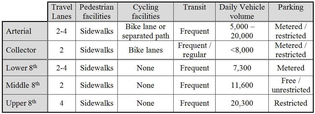
So outside of the MTP, recognizing there are no immediate capital plans changing the road, and to your point of it not being a very friendly road (dare I say “pre-Stroad”?) right now, what can we envision for the future of 8th St.?
The portion below Royal is exceptionally wide (more than 20m curb-to-curb in some spots), and is predominantly a pedestrian space, despite various attempts to corral and displace pedestrians to “get traffic moving”. This is the only part of 8th that has traffic volumes within the “City Collector” ideal – less than 8,000 vehicles per day. Everything about this tells me we should be reducing the driving width of this street, and improve the pedestrian realm. The massive daily flow of students between the New Westminster Station and Douglas College shouldn’t be crowded on a narrow sidewalk while waiting for pedestrian lights to change. The City should not have built the Anvil Centre (or allowed Plaza88 to be built) in such a way that parking garage entrances and loading bays disgorge into what should be a pedestrian-first place, but that ship has now sailed. This doesn’t mean we can’t think about re-allocating underused road space and shifting priorities to active users.
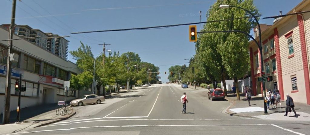
The portion between Royal and 6th Ave is essentially residential, although traffic counts here are higher. It operates as a true “collector” in the sense that the adjacent local roads dump traffic onto 8th as the route to the regional road system (be that Royal Ave, Canada Way, or wherever). The 15-m curb-to-curb width is still pretty wide for a two-lane road, and parking is both free and plentiful. A few curb extensions at important intersections (3rd Ave, 5th Ave) help improve pedestrian safety, but the open road feel definitely encourages travel speed greater than the regulated 50km/h, which combined with expansive asphalt and a general lack of trees, adds to the “barrier” feel you mention. There are some planned improvements around the new Middle School, but I doubt there would be any desire or political will to expand this road to 4 travelling lanes. The traffic doesn’t warrant it, and the impact on the livability of the community would be profound.
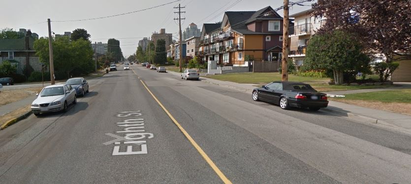
The portion between 6th and 10th is harder to peg. The lanes are a bit chaotic, parking intermittent, and at more than 20,000 vehicles per day, the traffic is pushing the upper limits of what an Arterial should be handling. This is one of the main connections from the Brow and Uptown to the regional road network (Canada Way), so I guess it isn’t surprising that the end of all the collectors is a logjam. At the same time, it has a High School, one of our most frequented parks, some high-density residential areas, and our largest commercial centre. It is crossed by two Greenways and is frequented by a large number of seniors. It is a mess, and likely the most Stroad-like road we have in New West, but solutions here are difficult to find. There will be re-writing of the interface with NWSS when the new school is built, but I don’t see much other relief any time soon, mostly due to vehicle load.
Finally, Bus Priority Lanes are just that: lanes where B-line type buses can have priority over traffic uses, although not specifically bus-only lanes, as they may share space with right-turning cars or general traffic in some locations. They come in several flavours, but are not common in urban areas of the Lower Mainland. Highway 99 has them approaching the tunnel, and East Hastings through Burnaby has a version of this. They might be considered in the future for 8th if traffic loads increase to the point where congestion seriously impacts bus operations, but I do not think we would consider installing more asphalt to make them happen.
And then there’s my favourite bug-bear: the ~90 second maximum activation delay (& 15 second crossing time) for the 7th Ave greenway crossing. ?
Thanks PJ, this post clears up a ton. This “Ask Pat” thing really works!
I think your analysis is spot on, especially regarding lower 8th Street. I hope that your views are widely shared at City Hall. It is unfortunate that budget isn’t allocated. I would at least hope that as re-development occurs sections of the street are improved to a standard that ultimately aligns with the MTP and what you’ve described here. A good example would road narrowing and street trees around FRMS, the Lotus development, and NWSS as all are developed. It would be a shame to re-build to current standards.
Perhaps something to look at is how street parking is designed. I’ve noticed that many municipalities group parking spots together into sections for roughly 5 vehicles and then intersperse green space for a few vehicle lengths, visually narrowing the road. I’d imagine that part of this is due to newer infrastructure being designed to modern standards. I have seen New West use this approach in newer developments like Victoria Hill and Port Royal. I’d love to see the same done in established areas. For 8th specifically this could work very well in the middle section. For the Upper section I’d wonder about getting rid of parking completely on the Moody Park side. I’m sure that there would be hell to pay but just think about the improved livability for those homes.
Related to this, I noticed that there are cycling improvements slated for Simcoe Park to better connect 9th Street to 8th and Royal. I’m interested to see how that would connect to lower 8th (what an awful grade though!).
Thanks again for the detailed reply.