Who pays for roads?

Once again, a casual conversation I had around a transportation issue led me to look for the data to support my long-held belief. I think I already had this data, as I like to convince myself that data is what most of my long-held beliefs are based on, but I’ve been wrong before, so it never hurts to check yourself, in case you are caught in the same conversation again. Run-on sentences are cool.

In this case, it was a version of the old “There is no need for road pricing, because I already pay for roads through gas taxes” or “Cyclists have no right to the road unless they register and pay a tax” narrative that I was arguing against. The central narrative is that gas-burners pay for roads, ostensibly through Gas Taxes or some other tax that non-drivers don’t pay. My long-held belief has been that gas taxes don’t pay for your roads, nor do ICBC rates or drivers licence renewal fees. The average cyclist likely pays just as much tax as the average car driver, they both pay for the roads (or, more likely, the average cyclist and the average driver are exactly the same person, as pretty much everyone I know who rides a bike also drives a car sometimes… but I digress). It did get me thinking – how much of what the average Lower Mainland driver pays for a car actually goes to maintain the road?

The first part of this is to determine just how much the average Lower Mainlander pays per year to drive the average car. Luckily CAA collects this data on an annual basis, so there is a single source for this number.

Click to make Bigger, borrowed from BCAA, probably illegally. 

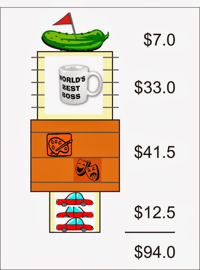
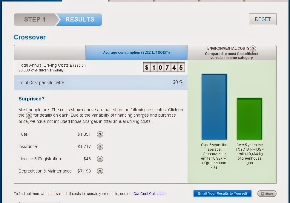
Let’s start setting assumptions, lots of people drive compact cars ($9,543 per year) and lots drive SUVs ($12,666 per year), most of the other categories are between these, so let’s pick the vehicle that is closest to the mid-point between these, which is a “Crossover” at $10,745 per year to operate. We have to also assume the average person drives an average amount, and their cost breakdowns are about average. You can see where I am going here, so I am going to try to reduce the use of the word “average” from here on in, and you are not going to use anomalous end-member data to criticize the following analysis. Deal?

Click to make Bigger, borrowed from BCAA, probably illegally. 

According to the Car-Knobbling Council BCAA, your Crossover will cost you about $1,831 a year in fuel, $1,760 in insurance and registration, and about $7,198 (!) in depreciation and maintenance. Neither Esso nor Canadian Tire build roads (excepting, of course, in that they pay taxes, and that goes to roads, but that is true no matter where you spend your money- at the Chevy dealership or the bike shop, so that argument goes nowhere), so we can assume that when we talk about paying for roads through our cars, we are talking about the paying tax for through using things that are part and parcel with using the road. The ICBC part is a special case I’ll have to hit on later, as this is already getting long.

Let’s figure out how much tax you pay to run your car.

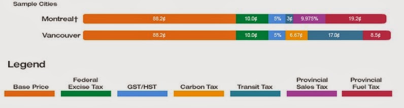
For that $1,831 you spend in a year for fuel, the calculator assumes your gas costs you $1.25 per litre, which works out to 1,465 Litres of fuel (I know gas is more expensive now, but I’d rather use numbers from an independent source than make shit up). According to the most independent source I can find, struggling gasoline retailers, $704.42 of this (just over 38%) is taxation at the retail level. This includes $146.50 in Federal excise tax, $97.15 in carbon tax, $249.05 in “transit tax”, $124.53 in Provincial gas tax, and $87.19 in GST.

Per-litre cost of fuel, according to Petro-Canada. Click to read.

These are each individual revenue streams, so I apologize in advance for the complicated stuff below.

The Federal excise tax goes into the Consolidated Revenue Fund – it all gets stuck in a big pile and mixed infinitely with all the other money the federal government collects, from the 16% duties on Ecuadorian wool socks to the income tax that came off your last paycheque. However, the Feds do pull $2 Billion a year out of that fund, (misleadingly) call it the “Gas Tax Fund” and transfer that directly to municipalities through a slightly convoluted allocation formula. Considering about 40 billion litres of gasoline are sold in Canada every year (not including diesel – which has an excise tax of $0.04/L on sales of 17 Billion litres annually), somewhat less than half of the Federal excise on gasoline is reinvested into this infrastructure fund (which makes the name misleading). Of that less-than-50% approximately 28% is spent on local roads and bridges.

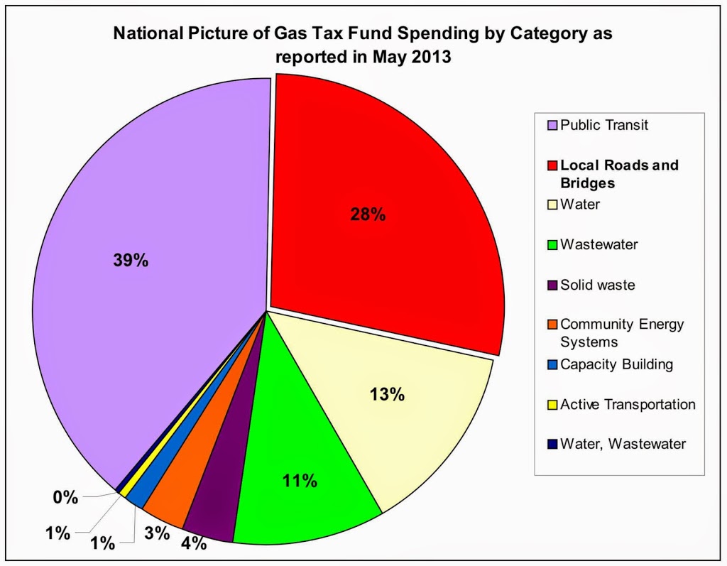
So crunching the numbers, the $146.50 of federal “gas tax” spent by the average person, about $20 goes towards roads.

The Carbon Tax is much simpler to work out. Exactly 0% of it goes to roads. The Province has been quick to point out and reinforce that the carbon tax is “revenue neutral” – it only goes to offsetting income and corporate taxes, and to providing a $200 cheque to rural British Columbians who own a house. All that just to kill a few jobs.

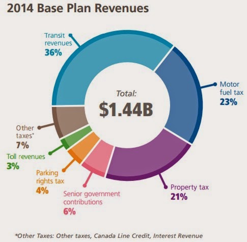
The “Transit Tax” is the TransLink gas levy, and some portion of that does directly go to maintaining roads and bridges. Looking at the TransLink Base Plan for 2014, we can see that TransLink collects $331 Million per year on its gas tax (on about 2 Billion litres of fuels sold in the TransLink area annually), which is 23% of its total revenue. Of this total revenue, about $119 Million (or about 8%) is spent on Roads, Bridges, and Cycling. So just as the federal money goes in to one big consolidated fund from which road money is drawn, the money TransLink gets is pooled and re-distributed (otherwise, their road spending would be decreasing as the gas tax revenues decrease, and that is not happening).

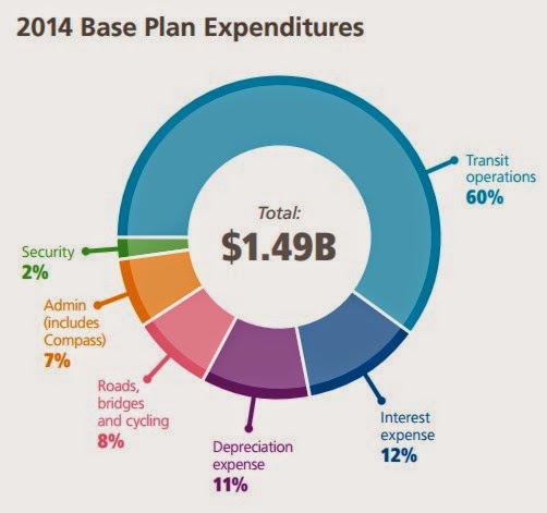
So of the $249.05 of Transit Tax, about $19.92 goes to the roads your drive that car upon.

The Provincial tax is much harder to estimate, as it all also goes to General Revenue, as does the GST hit, of which even a smaller proportion is transferred to the Province for roads spending. So let’s ignore the usual whinging about deadbeat have-not provinces and assume 100% of the GST comes back to the Province, and is pooled with the PST. How much does the Province spend on Roads? According to their recent financial plan, the annual Ministry of Transportation budget is about $800 Million, and a further $1.3 Billion on Infrastructure investment for transportation, meaning $2.1 Billion is spent on transportation. Of course that includes roads and bridges, along with cycling, transit, rail, Ferries (coastal and interior), gondolas, and the Mountain Pine Beetle Strategy (!?). This sounds like a lot, but it is only 4.7% of BC’s annual revenue. Given these very, very generous estimates, something like $10 of the average PST/GST cost of the annual gasoline bill goes to transportation.

That’s it: $50. That is the “toll” the average British Columbian pays every year for using the roads through gas taxes. Notably, this amounts to a “road tax” equal to one half of 1% of the annual cost of owning and operating a car.

There are, of course, major flaws with the above analysis, but none of them change the underlying premise.

First, most of the roads you use every day are paid for and maintained by your municipality, whose revenue sources do not include gas taxes (excepting the transfers from TransLink for the Major Road Network, and a portion of that Gas Tax Fund infrastructure money).

Thirdly, this analysis assumes that people who don’t buy gas do not pay even more for roads and bridges through their other expenditures. A daily driver gives $249 a year to TransLink in gas tax, but a daily 2-zone Transit Pass user gives $1,488 to TransLink in the same year. A daily SkyTrain user pays 6 times as much towards TransLink’s roads budget than someone who drives their car on a road every day. Of course, they both use the roads, just like pedestrians and cyclists and squirrels (who get off comparatively Scot free), but only the transit riders uses the Skytrain. Except that being on the SkyTrain gets her out of the way, “freeing up traffic”, which benefits the road driver.

The big exception is that people who don’t spend $1,831 a year on gas – or $7,000+ a year on a depreciating piece metal – don’t usually stick that extra money in the mattress. They usually spend it on other things. Like bicycle parts, or shoes, or peanut butter sandwiches (which is pedestrian fuel) or iPhone apps or pez dispensers or lottery tickets, beer and popcorn. Every dollar not spent on gas is likely spent in other ways, and when spending on things (be they car things or non-car things) they provide revenue in the form of sales taxes and in income taxes of the people who are selling stuff. That is the nature of our economy. Through the magic of “General Revenue”, just as much of those taxes go to funding roads and bridges as the sales taxes on gasoline does. In this sense, the more you use the roads, the less you likely pay for your share of their use.

As a bonus, that money is most likely not spent on things that destroy the atmosphere, as few things in our society have the same atmosphere-destroying capability on a dollar-by-dollar basis, than 1,400 Litres of gasoline.

Sustainable Spaces Dialogue

On Friday evening, more that 75 people showed up at Douglas College to talk about land use, sustainability, and the future or our public space in New Westminster. The event was the product of the remarkable young mind of New Westminster native Colin O’Neil and sponsored by the Rivershead Society of BC. I was honoured to be invited to provide one of the short talks that were intended to get the people in the room thinking about sustainable spaces.

I had 20 minutes, and wanted to talk about how New Westminster relates to the river (it being an event of the Rivershead Society) and about land use. These topics, during my research, kept pointing back at the history of the Port of New Westminster, and how its modern corollary Port Metro Vancouver impacts every part of our waterfront and the planning of our community.

As working on this talk took up much of my normal “blogging time” over the last little while, I figured I would repurpose my speaking notes into a blog post. So below are the notes I made, along with the photos that were projected during my talk. Note I tend to rift off on my notes during talks, but the framework is here. This is, more or less, what I meant to say, as opposed to what I actually said.


I want to talk about the pressures on land use on the riverfront, historically, and at present, and how that relates to sustainability of our community


The history of our City is tied to how we have used our waterfront, the geography of the waterfront, and the value we put on that place. In New Westminster, we are emerging from a long-term stagnation as the City waited for some form of renewal. That renewal only began with a re-imagining of how our waterfront is used. To understand how we address the Fraser River now, we need to look at some history.

The City is here because of the River. The Fraser has provided the City many things: water, food, transportation, a place to put our wastes. But mostly it gave us a reason to be here and a place to form our community.

Image source: New Westminster Archives Online

I became a geologist after studying geography, so when I look at land, I think about the physical forces that formed it, then about the human forces that shaped it. It was only 10,000 years ago that this place where we are today emerged from several millennia of ice cover, and the shoreline here was oceanfront. The Fraser River was choked with glacial sediments unlocked from melting ice, and the Fraser Delta grew westward from here. It was probably immediately after the ice left that the first people arrived here, no doubt using these shores for fishing, to hunt game, to gather food, to rest and gather. We don’t know who these first visitors were, but we know after several thousand years, their direct descendents, the Qayqayt had established villages here by the time that Europeans arrived by sea and down the river a mere 200 years ago.

Image source: New Westminster Archives Online

The European reasons for locating here was a simple military decision bred of ambitions of empire. Fort Langley was located in a swamp on the wrong side of the River, and when the inevitable American invasion came, the Brits would be overrun and driven in to the river. New Westminster had a steep shoreline on the correct side of the River to face down the invading hoards. It must have been a formidable position, as the hoards never actually arrived, and the invasion ended with the unfortunate death of one pig San Juan Island, but that is another story altogether.

The first boom for New Westminster came with the Fraser River, then Cariboo, gold rushes. Despite losing the status of Capital to politics a decade later, and the western terminus of the CPR two decades after that to more politics, New Westminster put some serious industrial roots down in those first decades… and it was all about the River.

Image source: New Westminster Archives Online

By 1887, Vancouver became the railhead, but New Westminster was home to Canada’s Pacific fishing fleet. There were already more than a dozen canneries on the Fraser River. There were also four sawmills, and ironworks and machine shops to support these primary resource industries. As the surrounding areas of Lulu Island and Southwestminster were cleared of trees and ploughed into farms, New Westminster became the centre for all agricultural trade in the new Province.

By the turn of the century (last one) a rail spur and the first bridge across the river were built – the same bridge that carries trains across the river today. The waterfront was remarkably diverse in its industrial function. As dredging increased and larger ships were permitted upriver, New Westminster became the most important Port on the west coast.

Image source: New Westminster Archives Online

It is hard for us younger folk here to envision how industrial New Westminster was around the time of World War 2. There were 15 lumber mills, a dozen fish canneries and places to can produce, a paper mill, a distillery, a brewery, meat packing, cold storage, fertilizer manufacturing, wood treatment, aircraft manufacturing and shipbuilding, and a huge machine shop, metalworking and woodworking industry to support it all. Almost the entire waterfront was taken up by one of the 120 or so manufacturing plants. And they used the River, for transport, water, raw materials, and a place to put their waste.

At the time of the cleanup-up to the Pier Park, they discovered large piles of metal shavings full of cutting fluids in the shore sediments. Apparently these old machine shops would cut a hole in the floor of the pier to dispose of their shavings, and when the pile built up to the base of the pier, they simply nailed down some planks to cover the hole, and cut another one 20 feet over. The River was a great place to put your waste!

Image source: New Westminster Archives Online

Shipping from the Port of New West peaked in 1956, and along with this peak came the peak of retail commercial business- the “Golden Mile” era of Columbia Street. Then things changed.

How many manufacturing plants do we have now?

The Port declined in the early 70s, and closed shop completely in 1980.

Why? Where did they go?

A large part of the answer is globalization. International competition and the emergence of Asian manufacturing made it cheaper to import the important service equipment these primary manufacturers required. The primary manufacturing industries (and the waterfront was dominated by sawmilling) were seeing consolidation, and a movement from local control to external control. When economic stresses of volatile global markets hit the single-resource industries, the old technology in these New West facilities was easy to shut down first in favour of newer or less labour intensive plants elsewhere.

At the same time, the Port declined as its original fortuitous location became untenable for the new ways of moving freight. The ships started to get too large for the Fraser River, but more importantly, those steep defensible slopes did not allow enough room on the shore side of the dock for roll-on-roll-off and containerization methods. The old warehouses of the New Westminster waterfront were decrepit, and no-one was interested in investing in their renewal.

Image source: New Westminster Archives Online

Part of the story of our City’s interaction with the River is told in the history of our Port Authority. The Port of New Westminster – the piers and buildings where the freight was stored and moved during the peak – belonged to the City. The New Westminster Harbour Commission was formed in 1913, and worked with City and the Board of Trade to promote the Port and fought off competition from Port of Vancouver. The Port had a global reach, trading to the USA, through the Panama Canal to Europe, and to the emerging Asian markets. The NWHC promoted connections to all of these places, advertised globally in a competitive market to get the most of the ongoing growth. And for a little while, that worked.

Eventually, the geographic constraints and change of technology through the 50s and 60s led to expansion of port facilities to Fraser Surrey Docks and Annacis Island, and the NWHC became the Fraser River Harbour Commission in 1965, covering the entire area upriver from Steveston to the Pitt River and Kanaka Creek in Maple Ridge.

The FRPC eventually became the Fraser River Port Authority, and that latter entity ceased to exist in 2008, when the Federal Government decided to amalgamate all Port operations between Horseshoe Bay and the US border into one authority – ”Port Metro Vancouver”.

I’m not going to get too deep into the reasons for this, but the impact obvious: a further reduction in local control of the waterfront. Especially as we look at the “mandate” and “vision” of this new regional authority:

Note the word “Gateway” always appears with a capital “G”, like most deities.

This is the part of the talk where I delve into subjectivity and opinion, but you need to get subjective here, because this speaks directly to how we value our river, our waterfront, and our community. What do we want our river to be? How do we want to use our waterfront? Do we want a say in how our community develops?

These statements don’t speak much to accountability to the local community, although the Port does seem interested in local benefits. But things actually get worse, because these statements changed in 2014  (which I write here over the old ones, to put the contrast in high relief):

Where they used to benefit us, they now wish to inspire us and fill us with national pride.

Maybe this is just a bit of Winter Olympic year hubris, we did, after all win a lot of gold metals this year, and everyone wants a piece of that…. but I’m having my doubts.

Here is visioning document put out by the Port a couple of years ago. This is meant to help the Port set plans for the coming decades – to envision the future they will need to plan towards. In this document, they set out 4 possible futures, and aside from the phallic symbolism, the colour scheme (green is good, red is bad) makes it clear what future the Port wants, and what it does not:

But look closely at how the Port, in their visioning, describes success:

Which in these uncertain times seems reasonable, I guess. The future is uncertain, the globe is headed to shit, but damn the torpedoes, full speed ahead!

Contrast this to the vision of failure, the fate we must avoid:

Local resiliency? Well being? The horror…

Again I ask, what do you want your port to provide to your community?


Maybe we don’t want to go back to having heavy industry on our waterfront, maybe we value the space differently. We now provide different values to the River: we want to look at it, be cooled by it, be provided ecosystem services from it. We still rely on it for work, we still want it to provide us fish, and these uses are ultimately compatible with using it for transportation.

This is not to say the Port doesn’t use our waterfront for industry. However, it uses it in very different ways, mostly to store things and move things on and off of trucks. Today, the Port wants to take more of our farmland to convert it into industrial space, not for moving goods on and off of boats, or even for adding value to goods or undertaking manufacturing – but to put things on and off of trucks.

Don’t worry about the ALR, they say, we need an “Industrial Land Reserve”, and we can just truck in all of our food.

Look at this piece of Port land, almost 40 hectares of industrial land belonging to the Port, rapidly being filled with warehouses. What’s missing?

The piers. There is no-where for a boat to tie up. How will they move things on and off of boats? There is one old one, rarely used for moving wood pulp onto boats as break bulk. Instead of building piers to move all of those containers you can see, or all the good in all of those massive warehouses, the Port is investing in building an overpass to connect this access road to the East-west Connector, and to expanding road access to the area, to more rapidly get the trucks to your neighbourhood streets.

This is the Captial-G “Gateway” in those mission statements. No wonder Councillor Harold Steves in Richmond gets all ornery about the Port buying the 10 hectares of active farm land just to the north of this picture.

Now, why am I hitting the Port so hard? Any why doesn’t councillor Steeves do something about it?

Because the Port is making these decisions that will decide what our waterfront (and our river, and our community) will look like over the coming decades, whether you like it or not. They are completely unaccountable to local concerns.

Will our waterfront become a larger export site for thermal coal, eking small profits from the exacerbation of the largest man-made global catastrophe of all time? The Port approves, despite community concerns.


Will we allow the Port to buy up more ALR land, convert it to industrial land by fiat, and lease it out for profit to trucking companies? At the same time they don’t pay living wages to those truckers? The Port argues this is important, and we cannot allow “local well-being” to slow their growth.


We live in New Westminster where the #1 livability issue is traffic: trucks and through-commuters. The region has spent $5 Billion building freeways for trucks, that Capital-G “Gateway Program”, the support of which the Port has made their mandate and vision. And they are not done. Another $3 or $4 Billion of your money will be spent replacing the Pattullo and the Deas Tunnel – the Gateway marches on. Meanwhile our livability suffers as we need to cut bus routes in our community for lack of investment. If we dream of expanding public transit, we will need to hold some sort of referendum at some point off in the future.

All of these issues and more have one thing at the core – the Port.

Remember how the industry of New Westminster changed, the forces that restructured out waterfront and caused decades of decline in our City: lack of local ownership, multinationals taking over the businesses, reliance on volatile foreign markets for resource goods instead of concentration on building local resiliency and well being.

I’m not saying I want to go back to cutting metal shavings into the river, but we have to recognize that the river can still be our connection to a bigger world and at the same time provide us a better community.

It is still why we are here. But now, more than ever, we have very little say about what happens to it. Remember those vision statements: Who does the Port answer to?

I, for one, don’t think local resiliency, sustainability, and livability should be feared.

What I’m working on

Wow, I haven’t posted anything in a few days, so I thought I should just update folks on what I’m doing these days, just so my dedicated reader (Hi Mom!) doesn’t worry.

You know, I have been busy. But I am consciously trying not to say “busy” when people ask me how I’ve been or what I am up to, because it seems a bit of a dodge that doesn’t really say anything. And everyone I know is really busy. Busy is our generation, it is our age, it is maybe our life stage. I’ll rest later, there are things to get done. Whatever, we’re all busy. I’ll just shut up about it now.

With what am I currently busy? Among other things, I have been working on research for this:

Link Here

I hope you can make it, it should be interesting.

on the Reasonable Approach.

This is a really good document.

I don’t want to go through the many reasons why I agree with the City of New Westminster’s position on the Pattullo Bridge, because I have said it all here before. For those new to my blog (Hi Tiffany!), there is a longish summary here.

If you really want the background from my viewpoint, you can read this, or this, or the two-part piece I did comparing the Pattullo to the Lion’s Gate that is here and here, or maybe look at this or this, or any of the other hundred posts about the transportation situation in our dear city I have slogged through over the last 5 years. But this is not about me, this is about the City of New Westminster finally laying their cards on the table, and in doing so, showing that they are holding a hell of a good hand.

New Westminster is clear that anything larger than a 4-lane bridge is undesirable. Surrey has stated that they prefer a 6-lane bridge. The difference, as explained in this 40-page volume put together by the City of New Westminster, is that the problem set which was agreed to by all parties (New Westminster, Surrey, and TransLink) more than a year ago does not support the building of a 5- or 6-lane bridge. Also, those larger options come with costs, both monetary costs that could be better invested in Transit South of the Fraser, and livability costs on New Westminster.

You can get the gist from reading the 4-page Executive Summary, and I think anyone interested in the topic of traffic in New Westminster and/or the future of the Pattullo Bridge really needs to read those 4 pages before commenting at length about New Westminster being “NIMBY” or “parochial” about this topic. I’m including you, Mayor Stewart. However, there are rewards for digging deeper into this position paper, because it actually provides data to back up its assertions.

After a review of the consultation and planning process to date (reminding TransLink once again that they don’t have a bridge-too-small problem, they have a bridge-too-old problem), the City lays out the case that there is no need for increased capacity as the problem is solved. To back this up, they demonstrate that the traffic volumes on the bridge were stable, or even declining until tolls arrived on the adjacent bridge, and the Ministry of Transportation started installing signs telling people to drive through New Westminster to save a few bucks.

All graphs here cribbed from the City report.

The City is also right to point out that the number of crossings of the river is increasing at such an (exponential?) rate that it is hard to rely on any modeling of actual or projected growth until new patterns establish themselves. I tracked the crossings back to 1900, they stuck to the more recent data:

I didn’t even ask permission to crib them from the report. 

Despite the rise in crossings, people still argue that more lanes are required to facilitate growth. I have heard Vancouver used as an example of growth not requiring more roads, but the City decided to look at the Richmond example, pointing out how it paradoxically grew by more than 50% since the last time there was any significant bridge construction (with the notable exception of the SkyTrain Bridge!)

but hey, i’m a taxpayer, so I paid for the report. 

In Sections 3.3 and 3.4 of the report, it is demonstrated that the building of a higher-capacity bridge is not supported by TransLink’s own Regional Transportation Strategy or the Regional Growth Strategy, and in fact counters those strategies by inducing development that is counter to the region’s goals. If any part of this report is weak, this is it, only because the City seems reluctant to toot its own horn. So I’ll do the tooting here.

New Westminster has the second-highest “alternative mode share” of any city in the Lower Mainland, second only to the City of Vancouver. This means that New Westminster residents are leading the region in finding alternatives to driving cars for their work commute, for shopping, or for school. New Westminster is building the compact, transit-oriented, pedestrian-friendly City that is outlined in the regional transportation and land use plans.

When Surrey says New Westminster is being intractable and a terrible regional partner, the point needs to be retorted, firmly, with bold print, underlined and in contrasting colour: How is doing exactly what our regional partners have agreed is the best course an example of being a bad partner!?! It is time Surrey started looking at their own choices: utterly failing to protect farmland; continuing to build unsustainable auto-oriented neighbourhoods; for continuing to threaten the livability of the entire region. When is the region going to start to question Surrey about the ways it is falling short in the “regional partner” relationships department?

This is why the City of New Westminster is taking the “Reasonable Approach” of asking TransLink and the Province to take the money that is being set aside for the Pattullo Bridge replacement, and invest it in helping Surrey meet its regional commitments.

I am also happy the City took a direct approach to the “Killer Bridge” stigma of the Pattullo. I have written about this meme and its accessory suggestion that the Pattullo must be replaced because it is so dangerous. The City effectively demonstrates this is not the case, and once again relies not on hearsay or platitudes, but the actual numerical data:

So I don’t feel bad having lifted them, at least I’m citing them.

The New Westminster report then goes through a comprehensive discussion of the preferred options, and touches on a number of aligned issues in the region and the City. This includes the current hot-button topic of truck impacts on New Westminster streets. On this topic, the report pulls out this provocative quote:

“It is of interest to note that on the other side of the Fraser River, the issues of truck traffic appear to have been substantially addressed. An article in BC Business reporting observations made by Jim Cox, then-CEO, Surrey development Corporation, noted ‘Cox gives full credit to Watts and her big-picture vision, such as changing the name of King George Highway to King George Boulevard, and creating South Fraser Perimeter Road to divert all that ugly truck traffic away from the heart of the city, making the streets walkable for the first time in Surrey’s car-loving history.‘ It is also worth noting that the costs of the South Fraser Perimeter Road have been covered by the Province.”

At the same time Surrey is touting the removal of trucks from it’s neighbourhood streets on the Province’s dime, it is advocating that the Province spend more money to put those same trucks on New Westminster’s neighbourhood streets.

I also liked that New Westminster included a statement on building a well-designed bridge, reflecting its importance as an icon in our skyline and a major piece of infrastructure in the middle of an urban neighbourhood:

“If a new structure is to be built, it should be the subject of an architectural design competition in which the cities of Surrey and New Westminster are full participants. If a rehabilitation option is chosen, attention should be paid in the design and maintenance processes to improve significantly the present appearance of the
bridge.”

And yes, the City of New Westminster has come down clearly and firmly in favour of tolling the Pattullo bridge, both as a revenue generator to pay for the replacement of refurbishment, and also as a “leveling of the playing field”, to end this unfortunate phase where our neighbourhood streets are deemed the cheap alternative to paying for road infrastructure through tolls.

Even better, with flat growth of traffic and tolls on a refurbished 4-lane or new 4-lane bridge, there will likely be no need for senior government money to build the project. As the Report summarizes:

“As the Pattullo Bridge Strategic Review indicated that the rehabilitated 4-lane option and the new 4-lane option can be self-funded through tolling, there is the question whether senior government funding is necessary if one of these options is selected. The reality is that public money that is spent on the bridge will restrict the ability to fund other much needed projects such as the Light Rail Transit (LRT) system within Surrey. The City is supportive of reallocating capital cost saving from a rehabilitated 4-lane bridge project or a new 4-lane bridge project to the much needed rapid transit system in the City of Surrey.”

So in summary: The City of New Westminster does not care if the Pattullo if refurbished or replaced, as long as it is tolled, has no more than 4 lanes, and is build in such a way that respects the urban character of the neighbourhoods and the importance of this structure to the region’s history. Not just because that is what the City wants, but because that solution fits the problem analysis best, saves senior governments money, meets regional goals, and reflects the values of our regional community in 2014. Compared to this well-assembled, well-supported, and comprehensive analysis, Surrey’s completely unsupported “More Bridge now!” argument is embarrassing.

Now to my major point: TransLink is stuck in neutral, Surrey is lobbying senior governments, and the Minister of Transportation sounds like he is listening. New Westminster has now presented a solid case, and will be taking this forward to those interested parties. The City needs your help. Get this report to your Residents’ Association meeting and get them to write a short letter of support to Mayor and Council. Are you active in the PAC in your local school? Ask then to also write a letter of support, and ask your school board to do the same. I hope the Downtown BIAs and the Chamber of Commerce, and even my friends at the NWEP can also get a letter together ASAP and show that this position is not that of a few people on Council, but is the position of a united, involved, informed, and proactive community.

TransLink cancelled the consultations that were supposed to be occurring right now in New Westminster to discuss the future of the Pattullo, but let’s make them hear from us anyway.

Tower Sold

At yesterday’s council meeting, the annual “State of the City” address by Mayor Wayne Wright and the 2013 Highlights and Accomplishments review by CAO Lisa Spitale were overshadowed by the announcement that the office tower on top of the Anvil Centre has been sold.

For people not paying attention, The Merchant Square office building is the 137,000 square feet of LEED Gold Class-A office space being built next to the New Westminster SkyTrain station. When the deal between the City and the UpTown Property Group (who were supposed to build and own the office tower) went south around last year’s election, the City made the bold choice to go ahead and build the tower itself. To the chagrin of some.

At the time, there was much speculative financial discussion on the internet about what the different aspects of the Anvil/Merchant Square cost, and where that money was coming from. Using the City’s info at the time, I drew these two sandwiches:

Where the $94 Million Budget was being spent. 
Where the $94 Million was coming from. 

As all of those were budget projections from three years ago, they can now be updated based on the new data released yesterday, (and please note, I have not had much time to look these over – so all the normal short work caveats apply) with a new calculation of the “shell cost” vs. the fit-out cost of the tower, and can include the cost of selling the tower:

Revised cost of the Anvil / Merchant Square project. 

The sale of the tower will cover the top bun of the sandwich. The deal put the cost for fit-out of the building on the purchaser, so the taxpayer is off the hook for that. The most important part of this is that all of the money the City borrowed from its Capital Reserves (budgeted at $33 Million, turned out to be $30 Million) to fund the construction of the tower will be returned to the reserves. The clear point made by City staff: No taxpayer money went into building the tower.

The Casino funds will still pay the $41.5 Million for the Anvil construction. The cost of listing and facilitating the sale is about $0.5 Million, and that will come out of the proceeds from the sale.

The parking structure cost $12.5 Million to build. This will be $1.5 Million from Casino funds, and $6 Million from the proceeds of the sale. The rest will need to be debt-funded from the Municipal Finance Authority. The short version is that the City is spending $5 Million to build a $12.5 Million parking structure. The Office Tower tenants will have first dibs on the parking, but will pay the City, at full market rates, to use it. That revenue will be used to pay for the parking structure. The new revenue sources look like this:

More importantly, the City will receive tax revenue from the 137,000 square feet of office space (estimated at $50 Million over 50 years), they will keep the revenue from the restaurant and coffee shop leases, and all of the spin-off economic benefits of having an office tower with 500+ workers downtown, and we got a spectacular Community Centre out of it all.

Sounds like a good deal to me.

Rethinking the Region 2014

I really need to get a life. I spent most of Saturday in a classroom at SFU Surrey. I was not taking a course for which I would receive credit, nor was I paying or being paid to be there. Instead, I was attending a workshop for planning geeks (which I may someday aspire to be) that was addressing some of the Big Questions about the future of Metro Vancouver.

It was actually interesting, inspiring, and fun. See my opening sentence.

The event was called “Rethinking the Region”, and despite it’s revolutionary-sounding title, it was actually a more nuanced discussion of the strengths and weaknesses of our current local and regional governance systems. The crowd was mostly SFU Urban Systems graduate students (a room full of young, fresh faced, excited, interested, smart and fashionable students only a slightly depressing reminder of how long ago I was a University Student!), with a fair amount of faculty, and a number of representatives from various local governments and other agencies.

There were many different aspects of the program that piqued my interest, I met some interesting people, and lots of fun discussion ensued. However, for this post I just want to run through my impressions of the opening addresses by the panel of experts that opened the program. I didn’t take extensive notes, so my apologies to the presenters if I mischaracterize their points here a bit – these are my impressions, not transcripts, so I will be careful with actual quotation marks.

The Program was opened by a former senior planner for New Westminster Ken Cameron, who set the tone by encouraging us to not think of Metro Vancouver as 22 border-sharing municipalities, but as a single entity- he used the term “organic” to describe this entity, and it was apt. It has defined boundaries (the sea, the mountains, the US Border), we can talk about it’s inputs (resources, goods, energy) and it’s outputs (resources, goods, wastes), and we can think about different components (roads, houses, businesses, schools) as interacting organs that process those through-puts.

His talk was broad-reaching but brought some interesting insights. One was that we are fortunate to live in a region with well defined and immutable limits, as this forces us to view our resources (including physical space) as finite, and therefore worthy of careful planning to allow us to manage them better.

A second point made by Cameron was that “governance always happens”. Whenever people get together, from the smallest hunter-gatherer tribe to the largest nations, humans assemble a governance system to allow us to work together. It doesn’t always work well, but it has always worked better if the governance has a coherent plan and everyone being governed is on the same page about the goals.

This last point sounds idealistic on the surface when it seems we are always arguing about every decision our governments make. It becomes more obvious when you think about the things our modern governance systems deliver: an economic system to trade goods, a system of laws to protect the security of the person, infrastructure to support our movements and our communication, etc. It is the details around the edges of these things that we argue about, as the essential structures and ideas have pretty much been worked out, or we wouldn’t be currently enjoying all of those things.

The second speaker was Anita Huberman from the Surrey Board of Trade. She was there to speak for the need of the region’s business communities to work together with a regional vision. She spoke of the need to get out of our municipal- and industry-specific silos, and start proactively sharing resources and infrastructure, while cutting politics out of the equation (that said, it was a Board of Trade speech, so totally non-political phrases like “cutting red tape” were common).The central message was a good one: we don’t have a single regional economic planning group working together, nor do we have a regional economic strategy. However, those much-coveted “global markets” are not interested developing relationships with individual cities as much as with economic regions.

There was room to develop this thought that we didn’t get into at the meeting. Did someone in Mapo-gu, Minami, or Abu Hamour really care if the person she was doing business in was in New Westminster or Surrey or Port Moody? They would, dollars for donuts, just call the area “Vancouver”, just as we would call the above areas just parts of Seoul, Yokohama, and Doha respectively. In this sense, Surrey probably benefits more from Vancouver’s international economic development efforts than vice versa…

Anthony Perl spoke next on the topic of the regional transportation system, obviously a topic close to my heart.

He started with an anecdote about Greater Toronto of the 1980’s, when it was described as “Vienna surrounded by Phoenix” – a region that had squared the circle of providing a compact, walkable and public-transit oriented downtown core based on smart growth principles surrounded by endless car-oriented suburban sprawl. This best-of-both-worlds scenario only hit its pre-Rob Ford crash when it became apparent that having two parallel and disparate transportation systems cost twice the money to move the same number of people. Arguably, it was this unaffordable path that led to the faux-taxpayer-revolt that is Ford Nation.

The object lesson is that Metro Vancouver appears to be, 30 years later, heading down this same economically perilous path. However, Perl outlined three potential ways we could design our regional transportation system, using symbolism from the 2010 Olympics (a time when, as he noted, Vancouver had the third highest transit mode share in North America, only after the two largest Cities: New York and Mexico City).

The “Gold Standard” is epitomized in Greater Zurich. They have a similar population and physical constraints as Metro Vancouver, and have a system where the automobile is secondary to a multi-mode and integrated transportation system. They share our limited top-down planning, and little senior government investment, and make many decisions via referenda (!). The two big differences are that they never ripped up the rail infrastructure they installed in the early 20th century, and they do not have a natural resource extraction economy that requires large-scale movement of bulk goods. “Going for Gold” in Greater Vancouver will require and organized regional coalition of stakeholders, not unlike the Gateway Council but with a broader mandate than the building of roads to move freight.

The “Silver Standard” would look like Lyon, France. This would require the following of strong global trends towards shifting to post-carbon mobility. Unlike Vancouver or Zurich, Lyon benefits from significant Federal investment in moving away from fossil fuels, and has a top-down approach that has brought high-speed rail between cities and Metro within them. They also have a carbon-tax like structure that provided incentives away from burning fuel, even if it isn’t called a carbon tax. This approach in Greater Vancouver would require significant investment by senior governments, not something that seems likely in today’s political climate.

The “Bronze Standard” is what we have seen work in New York City and London, England. In both cases, it was the actions of a single strong leader having the courage to make a bold change, though not breaking completely from traditional motor vehicles. Both Mayor Bloomberg and Mayor Livingston took concrete steps to end what Dr. Perl (tongue on slightly in cheek) calls “Road Socialism” – the idea that road use should be free, regardless of the cost to maintain those roads or greater costs to society. This Bronze approach, however, relies on a strong and visionary regional leader, something Greater Vancouver seems bereft of.

Dr. Tim Takaro then took the floor, ostensibly to talk about health policy in the region. Right from the start it was clear what he saw as our major public health issue: the “wicked problem” of climate change. He showed us a few familiar hockey-stick shaped graphs, and did a quick and extremely gloomy run-down of the storms, pestilence, drought and war that are in our future unless we leave 2/3 of our hydrocarbon reserves in the ground.

I loved this summary, and will talk more on this topic in an upcoming blog post:

The final panelist was the one who surprised me the most. Vicky Huntington is a two-term Independent MLA from South Delta, and she spoke frankly and compellingly about the struggles of regional governance, in the context of current threats to Democracy in out nation today. It was stunning.

She began by talking a bit about the struggle to get where we are today as a nation, and the importance of protecting our “strange, difficult, and messy democracy”. Not to put too fine a point on it, she made a case that this is the fight we must have right now in BC and in Canada, or we risk losing our voice, and our representation. There is a real and present risk of a “Plutocracy” developing through the slow and inexorable growth of influence on decision makers made by what can only be described as “wealth”. This is tipping the balance towards a certain economic point of view, and it may not be the one that serves our community or the globe best.

Our Democracy needs accountability, responsiveness, and clarity of purpose. Unfortunately, we are increasingly ruled by the needs of Corporations, who have no requirement to be accountable to the people. Although there is much current talk of “social licence” by Corporations who want to re-draw our region, that very licence is increasingly defined by them, not us.

They create these new consultation structures where they tell us what they are going to do, instead of having a conversation with us about what we will allow them to do. The conversation is narrowly defined and expertly directed by public relations professionals. We can see this with the recent Environmental Assessments (VAFFC, Northern Gateway, Kinder Morgan, Fraser Surrey Docks, etc.), with Port Metro Vancouver expansion plans, with the expansion of the Gateway and projects like the Pattullo Bridge. Quasi-government agencies (the Port, TransLink, BC Ferries, etc.) that ostensibly belong to us and work for us are leveraged by Corporate interests, and when the people try to speak up and challenge their intention, they have the power to shut that debate down. Through tightly-structured “consultations”, people cannot hear each others’ questions, cannot speak outside of the pre-designed debate. If they get too loud, they are marginalized and bullied.

Huntington spoke about the contrast between government and corporations, and how they impact environmental assessments, putting context into the “red tape” complaints of business. We live in a Confederation that is slow and methodical. Developing consensus and true consultation to assure the public interest is served is a deliberately cautious and organic process. That is the reality of a parliamentary system, and is an unfortunate (?) byproduct of our desire for “Peace, order, and good governance”. Corporations, in contrast, need to react quickly – this year, or preferably this quarter. They cannot afford to wait. They need their social licence, and they need it right now, because the anonymous shareholders demand it. Democracy just gets in the way. However, what Corporations see as the “inefficiency” of democracy is the only protection we have.

These were just the opening panel talks. They were followed by Q&A, and a long program of small-group dialogue and workshopping around the bigger themes, and maybe I will talk about those in future blog posts. Overall, it was a great program, and I learned a lot. Makes me want to go back to University…although I suspect I now lack the fresh face or vitality.